BlockBefore
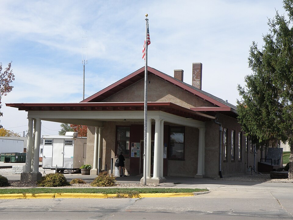
Photograph of Calmar Passenger Depot
Photograph by Karen Noecker, CC BY-SA 3.0. Via Wikimedia Commons.

Calmar Passenger Depot

Listed on the National Register of Historic Places in 2011.

From the record

“The Calmar Passenger Depot is a historic building located in Calmar, Iowa, United States. It was built by the Chicago, Milwaukee & St.”

Wikipedia article Calmar Passenger Depot, CC BY-SA 4.0.

One of 36 National Register listings published here for Winneshiek County · listed in 2011 · category: Building.

Sources: the Wikipedia article · the case file at the National Archives · the National Register database, National Park Service

The listing

  • What is counted as historic. The nomination lists 1 building as contributing to the listing.
  • Address. 201 N Maryville St, Calmar, 52132
  • When was it listed? March 2011
  • Category. building
  • Also known as. Advent & Development of Railroads in Iowa MPS
  • Township. Calmar township
  • Architectural style. Neoclassical architecture
  • Architect. Chicago, Milwaukee, St. Paul and Pacific Railroad
  • National Register reference number. 11000137 - the number the National Park Service assigned this property when it was listed, and the key its nomination file is catalogued under at the National Archives.

Fires near this property

14 since 2008

Regional context, not property-specific evidence. The federal wildfire occurrence database lists 14 fires within 5 miles of Calmar Passenger Depot between 2008 and 2020, burning about 414 acres in total. 1 started naturally. None was recorded as arson. Distance is straight-line from the map coordinates, so a fire counted here may appear on a neighbouring settlement's page as well.

Reported cause Fires
Missing data/not specified/undetermined7
Debris and open burning6
Natural1

The most recent of them, most recent first, with the day each was reported and the service that recorded it.

DateCause SizeReported by Name on the report
21 August 2008Missing data/not specified/undetermined30 acresIowa Department of Natural Resourcesnot named
4 July 2008Missing data/not specified/undetermined10 acresIowa Department of Natural Resourcesnot named
13 May 2014Debris and open burning15 acresIowa Department of Natural Resourcesnot named
26 April 2020Debris and open burning50 acresIowa Department of Natural Resourcesnot named
25 April 2020Debris and open burning10 acresIowa Department of Natural Resourcesnot named
21 April 2020Debris and open burningunder an acreIowa Department of Natural Resourcesnot named
19 April 2020Debris and open burning50 acresIowa Department of Natural Resourcesnot named
17 April 2015Debris and open burning2.0 acresIowa Department of Natural Resourcesnot named

Every fire recorded in Winneshiek County

Mines and quarries near this property

4 within 5 miles

Regional context, not property-specific evidence. The federal mineral resources record lists 4 workings within 5 miles of Calmar Passenger Depot: 3 past producers, 1 producer. 1 still produces. What was taken out: Stone, Crushed/Broken, Sand and Gravel, Construction. Distance is straight-line from the map coordinates, so a quarry counted here may appear on a neighbouring settlement's page as well.

Where SiteCommodity StatusRecorded
UnknownSand and Gravel, ConstructionPast Producer
Bullerman QuarryStone, Crushed/BrokenPast Producer
Ft Atkinson QuarryStone, Crushed/BrokenPast Producer
Horseshoe Bend QuarryStone, Crushed/BrokenProducer

Every working recorded in Winneshiek County

Storms near this property

55 since 1994

Regional context, not property-specific evidence. The National Weather Service names Calmar, the town this property stands in, in 55 storm reports between 1994 and 2025: 27 hail, 15 thunderstorm wind, 4 flash flood, 3 funnel cloud. No death or injury is recorded in these reports. Each account below is quoted exactly as the forecast office filed it, from the NOAA Storm Events Database, and each date opens the federal record of that event.

WhenEvent Place namedHarm What the report says
August 2016Flash FloodCalmar$1,800,000Runoff from heavy rains caused flooding to occur in and around Calmar, Fort Atkinson and Spillville. The flood waters caused the basement of one house to collapse in Calmar. Cars became stranded near U.S. Highway 52 around Calmar with one person having to stand on top of a car to get out of the flood waters. Rogers Creek near Fort Atkinson went out of its banks with water over several secondary roads. Flooding also occurred along Bohemian Creek in the western part of the county. Flood waters were knee deep in some residences and caused evacuations to occur near Ludwig County Park and County Highway B16 was closed due to the flood waters northwest of Spillville. Sandbagging efforts in Spillville had to be stopped because the water was rising too fast on Bohemian Creek and the Turkey River. The flood waters from the Turkey River isolated Spillville and prevented anyone from leaving or entering the town. One bridge near Spillville sustained damage from a tree swept up in the flood waters. Early estimates by the mayor of Spillville indicated 9 homes were seriously affected with water on the first floor and another 20 to 25 sustained less damage with water mainly in the basements.
July 2009HailCalmar$900,000Hail lasted approximately 10 minutes and broke windows and damaged siding.
July 2022Thunderstorm WindCalmar$840,000In and near Calmar, several buildings sustained wind damage and numerous trees were blown down. The roof was blown off a house, a business lost part of its roof, a system to move grain between storage silos was destroyed, a metal silo collapsed, the side of another silo was blown in, and a portion of the roof was removed from a large barn. At the community college, numerous buildings sustained roof and siding damage with doors blown in, windows broken, and a couple of vehicles were also blown over. The public schools sustained damage to their athletic fields. Metal bleachers at the softball field were blown over and pushed through a chain link fence. At the football field, the new press box was blown off the top of the stadium and two metal light poles were downed. Some rooftop air conditioning units were flipped over on the high school building.
July 2009HailCalmar$770,000This was the second round of large hail today.
July 1994Thunderstorm WindCalmar$50,000no account filed
June 1998Thunderstorm WindCalmar$45,000no account filed
September 2016LightningCalmar$30,000A house fire in Calmar was started by a lightning strike. The fire was contained to the attic with the house suffering moderate damage.
August 2025Flash FloodCalmar$20,000Emergency management reported basements flooded in Calmar.
July 2009Flash FloodCalmar$20,000Numerous small streams and drainage areas were flooded. A few roads south of Calmar had water over them.
July 2009HailCalmar$20,000Hail was 8 to 9 inches deep in places and crops were shredded.
May 2013Thunderstorm WindCalmar$15,000Some houses in Calmar had siding and shingles ripped off and numerous trees were snapped off.
June 2014Thunderstorm WindCalmar$10,000Several large trees were blown down in Calmar. One tree landed on a pickup truck.
June 2014HailCalmar$10,000Golf ball sized hail fell in Calmar.
August 2012HailCalmar$10,000Hail up to the size of quarters fell two miles northeast of Calmar. The hail stripped corn of its leaves and created drifts in road ditches.
July 2009HailCalmar$10,000Hail the size of golf balls was reported along Highway 52.
October 2006HailCalmar$10,000no account filed
May 2017Thunderstorm WindCalmar$8,000A wind gust to 82 mph occurred in Calmar. Several trees were blown down and one building suffered damage to the siding.
May 2000HailCalmar$6,000no account filed
July 2009Thunderstorm WindCalmar$5,000Trees were snapped, which were 12 to 18 inches in diameter.
August 2009Tornado (EF0)Calmar$5,000A tornado touch down one mile northeast of Calmar with sporadic tree and corn field damage.
October 2006HailCalmar$5,000no account filed
May 2017Tornado (EF0)Calmar$4,000A short-lived EF0 tornado occurred west of Calmar. The tornado started west of 265th Ave between 160th and 175th Streets and traveled southeast across Lake Meyer. A NWS Storm Survey Team found a broken line of tree damage along the path of the tornado.
June 2009HailCalmar$4,000no account filed
August 2021Thunderstorm WindCalmar$3,000Power lines were blown down in Calmar.
July 2009HailCalmar$3,000Some street flooding was reported as well.
July 2009HailCalmar$3,000no account filed
June 2000Thunderstorm WindCalmar$3,000no account filed
July 2020Thunderstorm WindCalmar$2,000A tree branch was blown down onto a garage in Calmar.
June 2014Thunderstorm WindCalmar$2,000A shed was blown over in Calmar.
July 2009HailCalmar$2,000Three inch diameter branches were also knocked down.
July 2004HailCalmar$1,500no account filed
June 2019Thunderstorm WindCalmar$1,000A large tree was snapped in Calmar.
June 2017Thunderstorm WindCalmar$1,000A tree was snapped off in Calmar.
August 2009Flash FloodCalmar$1,000A trained spotter reported torrential rainfall rates causing water to flow over sections of Highway 150 between Calmar and the Fayette County line.
June 2008HailCalmar$1,000A trained spotter reported penny to nickel size hail covering the ground. They also reported small branches down and extensive crop damage.
July 2009HailCalmar$1,000no account filed
August 2025HailCalmar-The public reported quarter sized hail near Calmar.
June 2024Thunderstorm WindCalmar-A few large tree limbs of up to 10 inch diameter were broken off near Calmar.
May 2017HailCalmar-Egg sized hail fell in Calmar.
June 2014Heavy RainCalmar-Near Spillville, 4 inches of rain fell.
June 2014Funnel CloudCalmar-A funnel cloud was sighted in Calmar.
May 2013Funnel CloudCalmar-Funnel clouds were sighted in Calmar.
June 2013Heavy RainCalmar-In Calmar, 3.5 inches of rain was reported.
September 2012HailCalmar-Quarter sized hail fell in Calmar.
September 2012HailCalmar-Hail the size of walnuts fell in Calmar.
August 2012Thunderstorm WindCalmar-An estimated a wind gust of 70 miles per hour occurred just outside of Calmar.
August 2009Heavy RainCalmar-An observer reported 2.32 inches of rain during the preceding 24-hours.
April 2014HailCalmar-no account filed
June 2011HailCalmar-no account filed
May 2003HailCalmar-no account filed
April 2002HailCalmar-no account filed
May 2000HailCalmar-no account filed
August 1999Funnel CloudCalmar-no account filed
May 1998HailCalmar-no account filed

Every storm recorded in Winneshiek County

Map coverage status

No historic map-sheet match is published for this property yet. That does not mean no map exists. This record needs a coordinate-quality review before it can be joined to a sheet boundary. Browse the county's mapped places while that work is pending.

Listed places nearby

6 within 8 miles

Other National Register properties close enough to walk or drive between, ordered by distance from this one. Both positions come from the same geocoding pass that matched these properties to their map sheets.

Photograph PropertyDistance Listed
Cooley-Whitney House3.8 miles1980
Fort Atkinson Bridge3.9 miles1998
Wenzil Taylor Building4.7 miles1979
Jacobson Farm5.0 miles1982
Ossian Opera House5.7 miles1979
Big Stone Mills5.9 miles

Sources for this property

National Archives recordThe nomination case file for reference 11000137 in Record Group 79.
Wikipedia articleCommunity-written account of this property, licensed CC BY-SA.
Winneshiek CountyAll 36 listed properties in this county.

Provenance

  • Listing record. National Park Service National Register of Historic Places, listed-properties dataset, current to 2026-05-22.
  • Map join. Address geocoded through the United States Census geocoder, then tested against the published boundary of every sheet in the USGS Historical Topographic Map Collection.
  • How this page is made. Listing fields come from federal records; map-sheet coverage is a labelled coordinate-to-boundary calculation, not a source-field claim.
  • Wildfire. Short, Karen C. 2022. Spatial wildfire occurrence data for the United States, 1992-2020 [FPA_FOD_20221014]. 6th Edition. Fort Collins, CO: Forest Service Research Data Archive. https://doi.org/10.2737/RDS-2013-0009.6 Collected with United States Government funding and usable without additional permissions or fees.
  • Mines and quarries. USGS Mineral Resources Data System (MRDS) https://mrdata.usgs.gov/mrds/ A work of the United States government, no copyright under 17 U.S.C. 105.
  • Storms. NOAA National Centers for Environmental Information, Storm Events Database https://www.ncei.noaa.gov/stormevents/ A work of the United States government, no copyright under 17 U.S.C. 105. Narratives are quoted verbatim from the National Weather Service report and are not edited or summarised.