BlockBefore
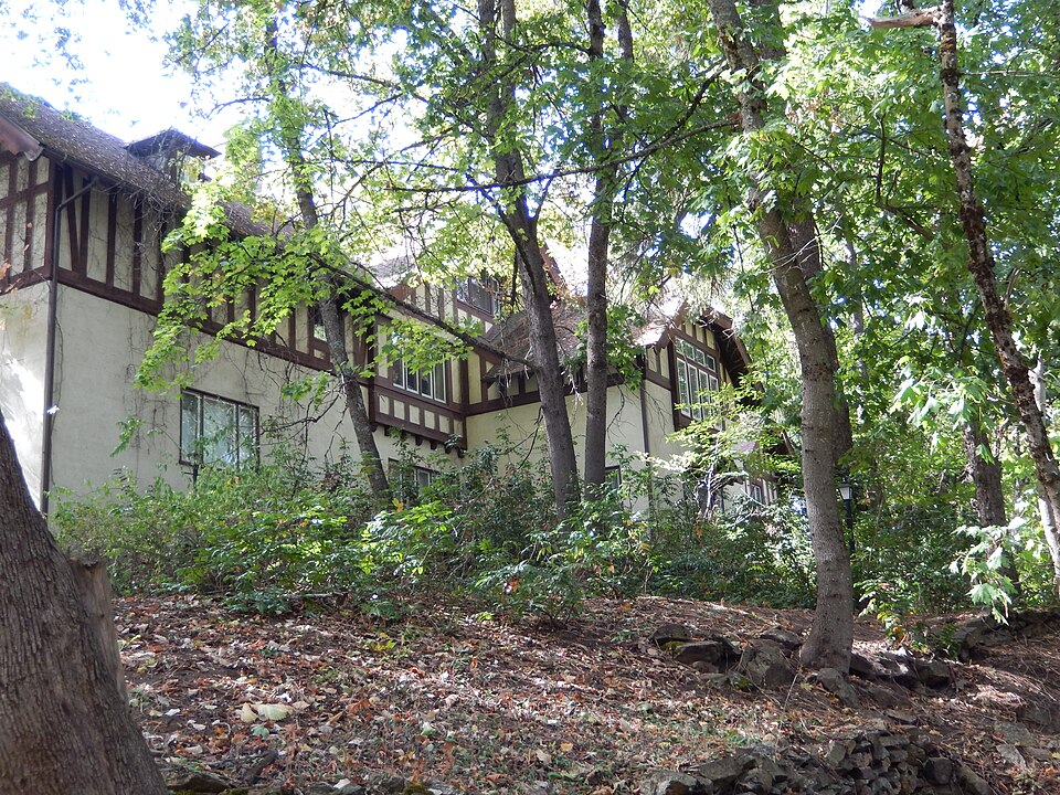
Photograph of John P. and Stella Gray House
Photograph by Nancy Reilly Young, CC BY-SA 3.0. Via Wikimedia Commons.

John P. and Stella Gray House

Built in 1913 (Tudor Revival architecture). Listed on the National Register of Historic Places in 1988.

From the record

“The John P. and Stella Gray House is a historic house in Coeur d'Alene, Idaho. It was built in 1910 for Boyd Hamilton, second mayor of Coeur d'Alene, Idaho and well known local banker.”

Wikipedia article John P. and Stella Gray House, CC BY-SA 4.0.

One of 45 National Register listings published here for Kootenai County · listed in 1988 · category: Building · built in 1913, Tudor Revival architecture, by Kirtland Kelsey Cutter.

Sources: the Wikipedia article · the case file at the National Archives · the National Register database, National Park Service

The listing

  • What is counted as historic. The nomination lists 2 buildingss as contributing to the listing.
  • Listed as. Gray, John P. and Stella, House - the National Register files a house under its owner's surname.
  • Address. 521 S. Thirteenth St., Coeur d'Alene, 83814
  • When was it listed? March 1988
  • Category. building
  • Census division. Coeur d'Alene
  • When was it built? 1913
  • Architectural style. Tudor Revival architecture
  • Architect. Kirtland Kelsey Cutter
  • National Register reference number. 88000272 - the number the National Park Service assigned this property when it was listed, and the key its nomination file is catalogued under at the National Archives.

Fires near this property

82 since 1992

Regional context, not property-specific evidence. The federal wildfire occurrence database lists 82 fires within 5 miles of John P. and Stella Gray House between 1992 and 2020, burning about 74 acres in total. 7 started naturally. 6 were recorded as arson. Distance is straight-line from the map coordinates, so a fire counted here may appear on a neighbouring settlement's page as well.

Reported cause Fires
Debris and open burning29
Missing data/not specified/undetermined14
Recreation and ceremony9
Misuse of fire by a minor8
Natural7
Arson/incendiarism6
Smoking5
Fireworks2
Equipment and vehicle use2

The most recent of them, most recent first, with the day each was reported and the service that recorded it.

DateCause SizeReported by Name on the report
8 September 2014Recreation and ceremonyunder an acreIdaho Department of LandsPRESLEY
7 September 2020Missing data/not specified/undeterminedunder an acreIdaho Panhandle National ForestBONNELL
4 September 2010Smokingunder an acreMica Area OfficeFERNAN HILL FIRE
3 September 1994Misuse of fire by a minor1.0 acresIdaho Department of LandsPUMPKIN PATCH
2 September 2003Smokingunder an acreIdaho Department of LandsSPORTSMAN
2 September 1996Debris and open burningunder an acreIdaho Department of LandsCOUGAR ESTATES
18 September 1994Misuse of fire by a minorunder an acreIdaho Department of LandsGARBAGE FIRE
16 September 2001Naturalunder an acreIdaho Department of LandsHIENE

Every fire recorded in Kootenai County

Mines and quarries near this property

10 of 14 shown

Regional context, not property-specific evidence. The federal mineral resources record lists 14 workings within 5 miles of John P. and Stella Gray House: 5 producers, 4 prospects, 2 occurrences, 2 past producers. 5 still produce. What was taken out: Sand and Gravel, Construction, Aluminum, Clay, Kaolin. Distance is straight-line from the map coordinates, so a quarry counted here may appear on a neighbouring settlement's page as well.

Where SiteCommodity StatusRecorded
QuarryStone, Crushed/BrokenProducer
Fernan Hill Clay DepositKaolinProspect
Kid Island Clay DepositClayOccurrence
Stanley Hill Clay DepositClay, AluminumProspectClay
Stockton Clay DepositKaolinProspect1920
Blue Creek Clay DepositAluminumOccurrence
Kid Island Clay DepositAluminumProspect
Couer D' Alene Pit and PlantSand and Gravel, ConstructionProducer
Couer D'Alene PitSand and Gravel, ConstructionUnknown
Gravel PitSand and Gravel, ConstructionProducer

Every working recorded in Kootenai County

Storms near this property

28 since 1997

Regional context, not property-specific evidence. The National Weather Service names Coeur d'Alene, the town this property stands in, in 28 storm reports between 1997 and 2024: 8 thunderstorm wind, 7 flood, 4 lightning, 3 flash flood. No death or injury is recorded in these reports. Each account below is quoted exactly as the forecast office filed it, from the NOAA Storm Events Database, and each date opens the federal record of that event.

WhenEvent Place namedHarm What the report says
June 2017LightningCoeur D Alene$50,000Lightning set fire to a home on Lake Coeur D'Alene during the evening of June 28th.
June 2007Thunderstorm WindCoeur D Alene$33,000no account filed
June 2007LightningCoeur D Alene$30,000no account filed
June 2007Thunderstorm WindCoeur D Alene$28,000no account filed
June 2022FloodCoeur D Alene$20,000Kootenai county sheriff reports 2 to 3 feet of water in the Coeur Dalene resort garage.
April 2012FloodCoeur D Alene$20,000Two homes in Fernan Village were flooded by Fernan Lake. Three other homes along the shores of the lake had their seawalls heightened with sandbags to prevent the lake from entering the homes.
March 2012FloodCoeur D Alene$20,000Two homes in Fernan Village were flooded by Fernan Lake. Three other homes along the shores of the lake had their seawalls heightened with sandbags to prevent the lake from entering their homes.
June 2007Thunderstorm WindCoeur D Alene$20,000no account filed
April 2000Flash FloodCoeur D Alene$15,000Due to heavy rain and snowmelt, rapid rises on the Wolf Lodge Creek caused several flooded basements and minor road damage.
July 2006LightningCoeur D Alene$15,000no account filed
January 2000FloodCoeur D Alene$15,000no account filed
August 1998WildfireCoeur D Alene$10,000Truck sparked a fire in a wheat field, damaging 15 acres of wheat and 1 acre of timber. Truck was also destroyed.
May 1997Thunderstorm WindCoeur D Alene$10,000tree in house from wind
July 1998Flash FloodCoeur D Alene$5,000heavy rains and local flooding in downtown Coeur d'Alene.
September 2024Thunderstorm WindCoeur D Alene$2,000The storm caused 1019 customers to lose power in Kootenai County. A gust of 54 MPH was recorded 2 miles South of Twin Lakes.
August 2007Thunderstorm WindCoeur D Alene$2,000no account filed
July 2012LightningCoeur D Alene$1,000Lightning struck and damaged the level sensor on the Tubbs Hill reservoir.
May 2023Flash FloodCoeur D Alene$500Heavy rainfall of near half an inch in an hour resulted standing water on several streets across Coeur D Alene. It included but was not limited to Government Way near I-90 and Appleway at 15th. Water depth ranged from 6 to 12 inches in spots. Radar estimated near 1 inch of rain. CWOP station G1914 recorded 0.77 of an inch of rain.
August 2019HailCoeur D Alene-A member of the public reported hail covering the ground to a depth of 2 inches with a maximum hail size of 1.5 inches.
March 2012FloodCoeur D Alene-Blue Creek Road washed out near Yellowstone Trail.
March 2012FloodCoeur D Alene-Flooding was reported along several low spots along Highway 97 between Cataldo and Harrison. While the exact location was unknown, some residents were forced to sandbag to avoid flooded creeks from seeping into their homes.
March 2012FloodCoeur D Alene-Excess runoff from heavy rain and snow melt resulted in sharp rises of Lake Coeur D Alene and minor flooding of its tributaries. Kid Island Bay Road which parallels the eastern shores of Kid Island Bay, a small outlet on the northwestern sections of Lake Coeur D Alene, had several inches of water over the roadway.
August 1999Heavy RainCoeur D Alene-4-6" inches of rain overnight. One boat sunk from accumulated rain water.
August 1999HailCoeur D Alene-3/4" hail
June 2010Heavy RainCoeur D Alene-no account filed
July 2007Thunderstorm WindCoeur D Alene-no account filed
March 2006Heavy RainCoeur D Alene-no account filed
May 2006Thunderstorm WindCoeur D Alene-no account filed

Every storm recorded in Kootenai County

Map coverage status

No historic map-sheet match is published for this property yet. That does not mean no map exists. This record needs a coordinate-quality review before it can be joined to a sheet boundary. Browse the county's mapped places while that work is pending.

Listed places nearby

6 within 8 miles

Other National Register properties close enough to walk or drive between, ordered by distance from this one. Both positions come from the same geocoding pass that matched these properties to their map sheets.

Sources for this property

National Archives recordThe nomination case file for reference 88000272 in Record Group 79.
Wikipedia articleCommunity-written account of this property, licensed CC BY-SA.
Kootenai CountyAll 45 listed properties in this county.

Provenance

  • Listing record. National Park Service National Register of Historic Places, listed-properties dataset, current to 2026-05-22.
  • Map join. Address geocoded through the United States Census geocoder, then tested against the published boundary of every sheet in the USGS Historical Topographic Map Collection.
  • How this page is made. Listing fields come from federal records; map-sheet coverage is a labelled coordinate-to-boundary calculation, not a source-field claim.
  • Wildfire. Short, Karen C. 2022. Spatial wildfire occurrence data for the United States, 1992-2020 [FPA_FOD_20221014]. 6th Edition. Fort Collins, CO: Forest Service Research Data Archive. https://doi.org/10.2737/RDS-2013-0009.6 Collected with United States Government funding and usable without additional permissions or fees.
  • Mines and quarries. USGS Mineral Resources Data System (MRDS) https://mrdata.usgs.gov/mrds/ A work of the United States government, no copyright under 17 U.S.C. 105.
  • Storms. NOAA National Centers for Environmental Information, Storm Events Database https://www.ncei.noaa.gov/stormevents/ A work of the United States government, no copyright under 17 U.S.C. 105. Narratives are quoted verbatim from the National Weather Service report and are not edited or summarised.