 Block
From the record
9 National Register listings published here.
Sources: the National Register database, National Park Service
53 topographic sheets cover 38 settlements here, and 9 properties are on the National Register of Historic Places.
9 National Register listings published here.
Sources: the National Register database, National Park Service
Every property in this county listed on the National Register of Historic Places, with the year it was listed and the federal nomination document.
| Photograph | Property | Type | Listed | Reference |
|---|---|---|---|---|
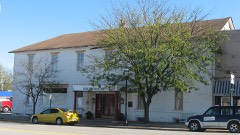 | Archer House Hotel | building | 1976 | 76000685 |
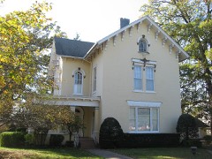 | Robert L. Dulaney House | building | 1997 | 97000382 |
 | First Congregational Church | building | 2003 | 02001753 |
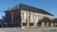 | Harlan Hall | building | 2001 | 01001309 |
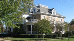 | John W. Lewis House | building | 1982 | 82002519 |
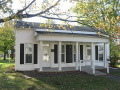 | Manly-McCann House | building | 1982 | 82002520 |
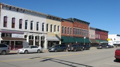 | Marshall Business Historic District | district | 2013 | 13000183 |
| Old Stone Arch Bridge | structure | 1978 | 78001117 | |
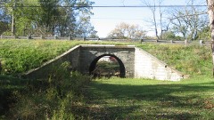 | Old Stone Arch, National Road | structure | 1975 | 75000643 |
Every wildfire the federal occurrence database records inside this county: 1 of them, burning under an acre. None started naturally and none was recorded as arson. Each settlement page carries the fires within five miles of it.
| Reported cause | Fires |
|---|---|
| Missing data/not specified/undetermined | 1 |
The five largest, by the area the report gives. None of them was recorded as arson.
| Date | Cause | Size | Reported by | Name on the report |
|---|---|---|---|---|
| 5 August 2007 | Missing data/not specified/undetermined | under an acre | Illinois Division of Forestry Resources | not named |
Every settlement page carries the fires within five miles of it - see the settlement index below.
The NOAA Storm Events Database holds 232 reports for this county, causing no deaths, no injuries and about $3,747,830 in recorded property damage. Each settlement page carries the reports that name it.
| Kind of event | Reports |
|---|---|
| Thunderstorm Wind | 116 |
| Hail | 64 |
| Flash Flood | 31 |
| Tornado | 13 |
| Flood | 7 |
| Lightning | 1 |
The most serious of them, by death, then injury, then recorded damage. The accounts are quoted exactly as the forecast office filed them.
| When | Event | Place named | Harm | What the report says |
|---|---|---|---|---|
| June 2013 | Flash Flood | Westfield | $2,000,000 | Periods of showers and thunderstorms which produced up to 4.00 inches of rain from June 25th into the morning of June 26th saturated the ground and swelled area creeks in northern Clark County. A round of thunderstorms during the afternoon of June 26th rapidly produced an additional 3.00 to 5.00 inches of rain resulting in widespread flash flooding. Most roads were flooded in the northern part of the county, and one road washed out about 5 miles north of Marshall. U.S. Highway 40 and State Route 1 were closed at times. Several homes and businesses in the city of Marshall suffered flood damage. The widespread flooding did not subside until late in the morning on June 27th. |
| June 2008 | Flood | Westfield | $500,000 | Copious amounts of rain, ranging from 9 to 11 inches fell across Clark County, mainly on June 6th. Nearly 100 homes were damaged by the flooding, and every county road was under water. Interstate 70 was closed from late in the evening on the 6th through much of the day on the 7th due to the flooding. Clark County was declared a disaster area due to the extensive flooding. |
| June 1999 | Tornado (F0) | Westfield | $350,000 | A tornado touched down 4 miles southeast of Westfield. It destroyed 3 machine sheds, a barn, and several trees. The nearby house did not sustain any damage. As it travelled to the northeast, another farm was hit. Two sheds, a brooder house, and half a barn were destroyed. The house sustained major damage with a large hole in the roof and almost every window was shattered. Debris was found up to two miles away. The house was shifted on its foundation which caused the concrete porch to split in half. A 2x4 flew through the house and was embedded into a wall. The tornado then lifted and dissipated 3 miles west of Clarksville. No injuries were reported and damage was estimated around $350,000. |
| June 2014 | Thunderstorm Wind | Casey | $100,000 | Numerous tree branches and power lines were blown down, causing a power outage to much of the town for several hours. A few 8 to 10-inch diameter trees were uprooted. |
| May 2017 | Thunderstorm Wind | Marshall | $75,000 | Numerous tree limbs and power lines were blown down across Marshall. An awning was damaged. |
| April 2020 | Thunderstorm Wind | Martinsville | $50,000 | Several utility poles were damaged on 1000th St between Highway 40 and 1200th Road. |
| May 2018 | Thunderstorm Wind | Westfield | $42,000 | Several power poles were blown down along IL-49 south of Westfield. |
| August 2012 | Thunderstorm Wind | Martinsville | $40,000 | Numerous trees were blown down, including a 20-inch diameter tree that fell onto power lines. Power was knocked out throughout Martinsville. |
| May 2018 | Thunderstorm Wind | Martinsville | $35,000 | Three semis were blown over on I-70 northeast of Martinsville. |
| June 2019 | Thunderstorm Wind | Marshall | $30,000 | A roof was partially ripped off a house and numerous tree branches were blown down. A fence was toppled on 8th street and the metal canopy at Lion's Den Pizza was partially destroyed. |
| April 2017 | Thunderstorm Wind | Marshall | $30,000 | Numerous trees were blown down. |
| April 2017 | Thunderstorm Wind | Martinsville | $25,000 | Numerous trees were blown down. |
| June 2016 | Thunderstorm Wind | Martinsville | $25,000 | Numerous tree branches and power lines were blown down causing a large power outage in Martinsville. |
| July 2015 | Thunderstorm Wind | Casey | $25,000 | Several trees and power lines were blown down in Casey. |
| June 1990 | Tornado (F1) | not stated | $25,000 | no account filed |
| March 1976 | Tornado (F1) | not stated | $25,000 | no account filed |
| April 2020 | Thunderstorm Wind | Martinsville | $20,000 | A gustnado on the leading edge of thunderstorms damaged power lines on the north side of Martinsville. |
| May 2018 | Thunderstorm Wind | York | $20,000 | Several large tree branches were blown down. |
| July 2017 | Lightning | Marshall | $20,000 | Lightning struck and damaged an Assisted Living Center in Marshall. |
| June 2016 | Thunderstorm Wind | Martinsville | $20,000 | Several trees were blown down just west of Martinsville. |
| June 2016 | Thunderstorm Wind | Marshall | $20,000 | Several power lines were blown down in Marshall. |
| July 2016 | Thunderstorm Wind | West Union | $20,000 | Several trees and tree branches were blown down in West Union. |
| February 2008 | Thunderstorm Wind | Martinsville | $20,000 | Numerous trees and power lines were blown down. |
| June 2008 | Thunderstorm Wind | Casey | $20,000 | Numerous trees, tree limbs, and power lines were blown down. |
| June 2019 | Thunderstorm Wind | Casey | $15,000 | Several large tree limbs were blown down and a roof was partially torn off a metal shed. |
| April 2017 | Thunderstorm Wind | West Union | $15,000 | Numerous trees were blown down. |
| November 2017 | Thunderstorm Wind | Casey | $15,000 | A few trees and several large tree branches were blown down across Casey. |
| June 2016 | Thunderstorm Wind | Casey | $15,000 | A few power lines were blown down. |
| August 2009 | Thunderstorm Wind | Marshall | $15,000 | Numerous 6-inch diameter tree limbs were blown down in Marshall. |
| June 2008 | Thunderstorm Wind | Westfield | $15,000 | Several tree limbs and power lines were blown down. |
| June 2019 | Thunderstorm Wind | Dennison | $12,000 | A large tree was blown onto a car. |
| May 2013 | Thunderstorm Wind | Clarksville | $12,000 | A few trees were blown down in Clarksville. |
| May 2009 | Thunderstorm Wind | Casey | $12,000 | A few trees were blown down in Casey. |
| March 2021 | Thunderstorm Wind | Clark Center | $10,000 | A semi truck was blown over on I-70 at mile marker 141. |
| July 2014 | Thunderstorm Wind | Marshall | $10,000 | Several tree branches were blown down in Marshall. |
| June 2010 | Thunderstorm Wind | Marshall | $8,000 | Several tree limbs were blown down. |
| April 1997 | Thunderstorm Wind | Westfield | $7,800 | Thunderstorm winds blew down numerous trees and power lines in Westfield. Two trees fell onto homes causing minor damage. Also, the winds damaged the roof of a mobile home. No injuries were reported but damage was estimated around $7,800. |
| May 2011 | Thunderstorm Wind | Casey | $7,000 | A tree was blown down onto a house in Casey. |
| May 2013 | Thunderstorm Wind | Marshall | $6,000 | A tree was blown down onto a house in Marshall. |
| May 2011 | Thunderstorm Wind | Marshall | $6,000 | A utility pole was blown down in Marshall. |
| August 2009 | Thunderstorm Wind | Martinsville | $5,000 | Three large trees were snapped just north of Martinsville. |
| October 2007 | Thunderstorm Wind | Martinsville | $5,000 | Several tree limbs were blown down. |
| July 2014 | Thunderstorm Wind | Martinsville | $3,000 | Two one-foot diameter poplar trees were blown down in Martinsville. |
| June 2011 | Thunderstorm Wind | Martinsville | $3,000 | A large tree was uprooted in Martinsville. |
| June 1985 | Tornado (F0) | not stated | $2,500 | no account filed |
| June 1970 | Tornado | not stated | $2,500 | no account filed |
| May 2013 | Thunderstorm Wind | Marshall | $2,000 | A traffic light was blown down in Marshall. |
| May 2013 | Thunderstorm Wind | Martinsville | $2,000 | A tree was blown down across a road in Martinsville. |
| April 2013 | Thunderstorm Wind | Martinsville | $2,000 | A tree was blown down onto Cumberland Road about 2 miles east-northeast of Martinsville. |
| July 2008 | Thunderstorm Wind | Marshall | $2,000 | A tree was blown down and blocked the westbound lane of Clarksville Road. |
| June 2008 | Thunderstorm Wind | West Union | $1,000 | A large tree was blown down. |
| July 1982 | Tornado (F0) | not stated | $30 | no account filed |
| May 2025 | Tornado (EF1) | York | - | This tornado crossed from Crawford County into southern Clark County about 0.5 miles west of West York at 6:48 PM CDT. It continued eastward, causing EF-1 damage to trees and a farm outbuilding on the west side of the town of York before crossing the Wabash River into the National Weather Service Indianapolis County Warning Area in Sullivan County, Indiana at 6:54 PM CDT. |
| April 2025 | Tornado (EF1) | Livingston | - | A tornado touched down in a field about 3 miles south of Marshall just south of I-70 at 7:02 PM CDT. The tornado crossed I-70 where it blew over 2 semi trucks, then continued northeastward and damaged 8 large buildings and several trees at a hog farm along East 1950th Road. It then snapped several trees and tree branches and caused minor damage to outbuildings before crossing into Edgar County near the intersection of North Fern Lake Road and East 2250th Road at 7:08 PM CDT. |
| April 2025 | Tornado (EF2) | Oilfield | - | This tornado crossed from Cumberland County into Clark County south of the intersection of County Road 000 East and County Road 1530 North at 6:48 PM CDT. It continued northeastward, damaging numerous trees and outbuildings and causing minor roof and siding damage in the community of Cleone and just north of Clarksville before passing into Edgar County just west of Flemington Creek at 7:02 PM CDT. |
| April 2025 | Thunderstorm Wind | Casey | - | Numerous tree limbs were blown down. |
| April 2025 | Thunderstorm Wind | Snyder | - | A carport was damaged. |
| April 2025 | Thunderstorm Wind | Clarksville | - | An outbuilding was destroyed and several power poles were broken. |
| June 2025 | Thunderstorm Wind | Oilfield | - | A large tree branch was blown down and fell through the roof of a home. |
| March 2024 | Hail | Marshall | - | Cars were dented by the hail. |
The Survey's mineral resources record lists 15 workings inside this county. 7 still produce and 8 are closed or unrecorded. Each settlement page carries the workings within five miles of it.
| Commodity | Workings |
|---|---|
| Sand and Gravel, Construction | 7 |
| Stone, Crushed/Broken | 7 |
| Clay | 1 |
The least common of them first, because a county's hundredth gravel pit says nothing its first ten did not.
| Where | Site | Commodity | Status | Recorded |
|---|---|---|---|---|
| Beacon Shale Exposure | Clay | Prospect | ||
| Casey | Stone, Crushed/Broken | Producer | ||
| Casey South Quarry | Stone, Crushed/Broken | Past Producer | ||
| Clark County Pit 1 | Sand and Gravel, Construction | Producer | ||
| Clark County Pit 2 | Sand and Gravel, Construction | Producer | ||
| Clark County Pit 3 | Stone, Crushed/Broken | Producer | ||
| Geisert Quarry & Mill | Stone, Crushed/Broken | Producer | ||
| Kuykendall Pit | Sand and Gravel, Construction | Past Producer | ||
| Lawrence East & West Dredge | Sand and Gravel, Construction | Producer | ||
| Lehigh Main Quarry | Stone, Crushed/Broken | Past Producer | ||
| Mengel Pit | Sand and Gravel, Construction | Past Producer | ||
| Rennels Pit | Sand and Gravel, Construction | Producer | ||
| Stanfield Pit | Sand and Gravel, Construction | Past Producer | ||
| Unnamed Limestone Quarry | Stone, Crushed/Broken | Past Producer | ||
| Unnamed Limestone Quarry | Stone, Crushed/Broken | Past Producer |
Named settlements recorded in the Geographic Names Information System, each with the topographic sheets covering it. Villages, hamlets and abandoned places alike. Each is shown with the nearest named watercourse or landform and the survey quadrangle it falls on.
Anderson township · 62441 · On Blackburn Branch · Snyder quadrangle
15 sheets, 1932 to 1986
Dolson township · 62441 · On Snakeden Branch · Clarksville quadrangle
17 sheets, 1936 to 1998
Parker township · 62442 · On McNary Branch · Westfield East quadrangle
17 sheets, 1936 to 1998
Wabash township · 62441 · On East Little Creek · Marshall quadrangle
15 sheets, 1932 to 1986
Wabash township · 62441 · Marshall quadrangle
15 sheets, 1932 to 1986
No longer a settlement
Wabash township · 62441 · On East Little Creek · Marshall quadrangle
15 sheets, 1932 to 1986
Martinsville township · 62442 · On Norman Branch · Casey quadrangle
17 sheets, 1936 to 1998
York township · 62477 · On Little Creek · West Union quadrangle
14 sheets, 1953 to 1998
Westfield township · 62474 · On Mill Creek · Westfield East quadrangle
17 sheets, 1936 to 1998
The vanished settlements of Clark County: the places named above that are no longer on the map.