BlockBefore
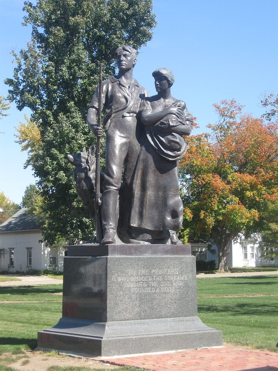
Photograph of The Pioneers
Photograph by LeeT, Public domain. Via Wikimedia Commons.

Pioneers, The

Listed on the National Register of Historic Places in 2001.

From the record

“The Pioneers , also known as Pioneers , is a bronze sculpture in Central Park in Elmwood, Illinois. The sculpture is one of several works by Lorado Taft in Elmwood, his birthplace.”

Wikipedia article The Pioneers (sculpture), CC BY-SA 4.0.

One of 35 National Register listings published here for Peoria County · listed in 2001 · category: Object.

Sources: the Wikipedia article · the case file at the National Archives · the National Register database, National Park Service

The listing

  • What is counted as historic. The nomination lists 1 object as contributing to the listing.
  • Address. Central Park, N,. Magnolia St., Elmwood, 61529
  • When was it listed? May 2001
  • Category. object
  • Township. Elmwood township
  • National Register reference number. 01000117 - the number the National Park Service assigned this property when it was listed, and the key its nomination file is catalogued under at the National Archives.

The ground it stands on

17,121 words

The chapter on Elmwood Township in The History of Peoria County, Illinois. Containing a History of the Northwest--history of Illinois--history of the County, Its Early Settlement, Growth, Development, Resources, Etc., Etc. .., published 1880 names Elmwood. This is what it says, exactly as the scans read.

Elmwood is in town nine noitli, range five east, and is one of the western tier of townships in Peoria county. It was originall}- about one half prairie and one half timber, and possesses a superior soil. The surface is gently undulating and well adapted to agriculture. Some parts are slightly broken by the branches of Kickapoo creek, along which are some of the finest coal mines in the county. The township is crossed by two branches of the C. B. & Q. railroad, wliich form a junction at Elmwood city. The Peoria branch connects it with that city, twenty-five miles distant. Elmwood city is located on sections seven and eight, was laid out in 1854, and is a flourishing place of 2,000 population ; is next to Peoria city the largest and most important commercial manufacturing town in Peoria county. Durino- the year ending June 1, 1879, 681 cars of produce, and 1010 of coal were shipped from Elmwood.

Passage source: The History of Peoria County, Illinois. Containing a History of the Northwest--history of Illinois--history of the County, Its Early Settlement, Growth, Development, Resources, Etc., Etc. .., published 1880.

First Settlers. - John Ewalt was the first settler in Elmwood township. He came from Sangamon county. Ills., on the 1st of May, 1831, located on section twenty-nine, and broke tlie first soil. Isaac Doyle was the next, settling on Section thirty. May 1, 1832. In the Fall of 1834, W. J. Phelps settled on section eighteen, where he now resides. During the Winter of the same year Fountain Watkins settled and made improvements on section twenty-nine. Avery Dalton settled on section nineteen in 1837, coming from Fulton count}-. The early pioneers went thirty-five miles to mill. One barrel of Kanawha salt cost them $20.58. Isaac Doyle was the first justice of the peace, elected in 1883. The first marriage was that of Abner Smith to Eliza Ann Doyle, in March, 1834. The first child born in the township was Rebecca Ewalt, February, 1834. Daniel Fast was the first school teacher. The post office was established in the township in 1847, at the residence of Hon. Wm. J. Phelps, which was first called Elmwood, before the name was given to the township. Mr. Phelps was the first postmaster.

Passage source: The History of Peoria County, Illinois. Containing a History of the Northwest--history of Illinois--history of the County, Its Early Settlement, Growth, Development, Resources, Etc., Etc. .., published 1880.

Machine-read from a century-old scan, so expect the errors a machine makes: misspelled names, dropped words, stray characters.

Read the whole chapter on Elmwood Township - 17,121 words on its settlement, mills, schools and churches.

Fires near this property

7 since 2002

Regional context, not property-specific evidence. The federal wildfire occurrence database lists 7 fires within 5 miles of Pioneers, The between 2002 and 2018, burning about 52 acres in total. None started naturally. 1 was recorded as arson. Distance is straight-line from the map coordinates, so a fire counted here may appear on a neighbouring settlement's page as well.

Reported cause Fires
Smoking2
Missing data/not specified/undetermined2
Debris and open burning2
Arson/incendiarism1

The most recent of them, most recent first, with the day each was reported and the service that recorded it.

DateCause SizeReported by Name on the report
26 March 2003Arson/incendiarism25 acresIllinois State Fire Marshal's Officenot named
23 March 2013Debris and open burning20 acresIllinois Division of Forestry Resources323133
23 March 2013Missing data/not specified/undeterminedunder an acreIllinois Division of Forestry Resources323132
23 March 2002Smokingunder an acreIllinois State Fire Marshal's Officenot named
22 March 2018Debris and open burning2.0 acresIllinois Division of Forestry Resources2018186
31 December 2002Smoking1.0 acresIllinois State Fire Marshal's Officenot named
4 October 2004Missing data/not specified/undetermined4.0 acresIllinois State Fire Marshal's Officenot named

Every fire recorded in Peoria County

Storms near this property

39 since 1995

Regional context, not property-specific evidence. The National Weather Service names Elmwood, the town this property stands in, in 39 storm reports between 1995 and 2024: 27 thunderstorm wind, 9 hail, 2 tornado, 1 flash flood. No death or injury is recorded in these reports. Each account below is quoted exactly as the forecast office filed it, from the NOAA Storm Events Database, and each date opens the federal record of that event.

WhenEvent Place namedHarm What the report says
June 2010Tornado (EF2)Elmwood$85,000,000A tornado crossed the Knox-Peoria County line 1.1 miles west of Elmwood, then continued southeastward through the town of Elmwood. Considerable structural damage occurred to 10 homes, 30 businesses and nearly two dozen vehicles in downtown Elmwood, amounting to approximately $85 million in damages. There was a total of about 80 people, some that were attending an outdoor festival in the downtown and some that were at a theater, that took shelter in the basement of the movie theater. As a result, there were no injuries. The tornado dissipated 1 mile east of Elmwood.
November 2016HailElmwood$2,000,000Wind-driven hail caused significant damage to the roofs and siding of 50 houses in Elmwood. One house suffered a broken window. Numerous cars were damaged as well.
June 2009Thunderstorm WindElmwood$1,100,000A grain bin was blown down. Numerous trees and power lines were knocked down as well. Most homes in the town of Elmwood experienced damage due to falling trees and limbs.
November 2020Thunderstorm WindElmwood$100,000The roof of an apartment building was blown off.
June 2014Thunderstorm WindElmwood$35,000Numerous trees up to 12 inches in diameter were blown over on the southeast side of Elmwood.
April 1997Tornado (F0)Elmwood$25,000no account filed
April 2014Thunderstorm WindElmwood$12,000Several tree limbs were blown down in Elmwood.
May 2013Thunderstorm WindElmwood$12,000Several large tree limbs were blown onto power lines at Illinois Route 78 and Schissler Road.
October 2017Thunderstorm WindElmwood$8,000Several 8 to 12-inch diameter tree branches were snapped.
July 2011Thunderstorm WindElmwood$8,000Trees were blown down across Route 8 in Elmwood.
July 2024Thunderstorm WindElmwood-A small outbuilding was destroyed. 71 mph winds were measured less than a mile away.
May 2023Thunderstorm WindElmwood-Tree limbs were blown onto powerlines on the west side of Elmwood.
August 2023Thunderstorm WindElmwood-Power lines were blown down. Additionally, a large tree was split and downed over a road in Elmwood.
July 2020Thunderstorm WindElmwood-Several trees were blown down.
August 2020Thunderstorm WindElmwood-A ten-inch diameter tree was blown across IL-78 near Graham Chapel Road.
June 2017Thunderstorm WindElmwood-An 18 to 24-inch diameter tree was blown down.
August 2014Thunderstorm WindElmwood-A 6 to 7-inch diameter branch was broken off a cedar tree.
June 2010Flash FloodElmwood-Around 2.50 of rain fell between 0630 and 0830 CST on top of already saturated ground. This produced rapid flash flooding in western and central Peoria County. Most rural roads were flooded, from Hanna City toward Farmington to Elmwood, as drainage ditches were overflowing.
April 2006Thunderstorm WindElmwood-Numerous trees, power poles and power lines were blown down.
May 2004Thunderstorm WindElmwood-A large tree was blown down.
July 2003Thunderstorm WindElmwood-Widespread wind damage to trees and power lines was reported in Elmwood, Princeville, Mossville, Chillicothe, Peoria and Bartonville. Some of the fallen trees landed on a couple of homes causing minor roof damage. A couple of sheds were destroyed and part of a roof on a business in Princeville was blown off. No injuries were reported.
August 2000Thunderstorm WindElmwood-Thunderstorm winds blew down several large trees. Also, numerous shingles were blown off of a garage 3 miles south of Laura.
September 2000Thunderstorm WindElmwood-A corn field was damaged in the area as a result of straight line winds.
June 2000Thunderstorm WindElmwood-Several large tree limbs and power lines were blown down.
April 1999Thunderstorm WindElmwood-As a line of severe storms moved into Peoria County, a power pole was snapped off at the ground near Elmwood and an awning at a gas station in Brimfield was damaged. No injuries were reported.
July 1999Thunderstorm WindElmwood-Several large tree limbs were blown down in Elmwood.
May 1998Thunderstorm WindElmwood-Thunderstorm winds blew down several large trees in Elmwood. No injuries or damage to property were reported.
June 1998Thunderstorm WindElmwood-Thunderstorm winds blew down numerous trees, tree limbs, and power lines in an area extending from Elmwood to Peoria. Some of the trees fell onto homes causing structural damage. No injuries were reported and no damage estimate was available.
March 1998Thunderstorm WindElmwood-As a line of severe thunderstorms moved through Peoria county, numerous reports of damage were received. Six miles south of Elmwood, several small greenhouses and a metal building were damaged. In Peoria, a 200 foot by 75 foot section of the post office garage roof was blown off and curled into a ball and the second story of an abandoned business collapsed due to the thunderstorm winds. No injuries were reported. Throughout the county numerous trees, tree limbs, power poles, and power lines were blown down. No damage estimate was available.
May 1995Thunderstorm WindElmwood-Thunderstorm winds blew down numerous trees. One tree fell onto a house and caused minor damage to the roof. Also, there was some damage to five outbuildings. No damage estimate was available.
July 2024Thunderstorm WindElmwood-no account filed
February 2017HailElmwood-no account filed
April 2015HailElmwood-no account filed
June 2014HailElmwood-no account filed
March 2006HailElmwood-no account filed
April 2006HailElmwood-no account filed
July 2003HailElmwood-no account filed
May 2002HailElmwood-no account filed
May 1998HailElmwood-no account filed

Every storm recorded in Peoria County

Map coverage status

No historic map-sheet match is published for this property yet. That does not mean no map exists. This record needs a coordinate-quality review before it can be joined to a sheet boundary. Browse the county's mapped places while that work is pending.

Listed places nearby

1 within 8 miles

Other National Register properties close enough to walk or drive between, ordered by distance from this one. Both positions come from the same geocoding pass that matched these properties to their map sheets.

Photograph PropertyDistance Listed
Zion Episcopal Church6.2 miles2024

Sources for this property

National Archives recordThe nomination case file for reference 01000117 in Record Group 79.
Wikipedia articleCommunity-written account of this property, licensed CC BY-SA.
Peoria CountyAll 35 listed properties in this county.

Provenance

  • Listing record. National Park Service National Register of Historic Places, listed-properties dataset, current to 2026-05-22.
  • Map join. Address geocoded through the United States Census geocoder, then tested against the published boundary of every sheet in the USGS Historical Topographic Map Collection.
  • How this page is made. Listing fields come from federal records; map-sheet coverage is a labelled coordinate-to-boundary calculation, not a source-field claim.
  • Wildfire. Short, Karen C. 2022. Spatial wildfire occurrence data for the United States, 1992-2020 [FPA_FOD_20221014]. 6th Edition. Fort Collins, CO: Forest Service Research Data Archive. https://doi.org/10.2737/RDS-2013-0009.6 Collected with United States Government funding and usable without additional permissions or fees.
  • Storms. NOAA National Centers for Environmental Information, Storm Events Database https://www.ncei.noaa.gov/stormevents/ A work of the United States government, no copyright under 17 U.S.C. 105. Narratives are quoted verbatim from the National Weather Service report and are not edited or summarised.