BlockBefore
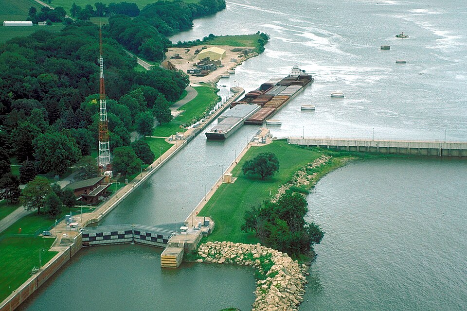
Photograph of Starved Rock Lock and Dam
Photograph by U.S. Army Corps of Engineers, photographer not specified or unknown, Public domain. Via Wikimedia Commons.

Starved Rock Lock and Dam Historic District

Built in 1933. Listed on the National Register of Historic Places in 2004.

From the record

“Starved Rock Lock and Dam, also known as Lock and Dam No. 6, is a lock and dam facility managed by the U.S. Army Corps of Engineers along the Illinois River, near Starved Rock.”

Wikipedia article Starved Rock Lock and Dam, CC BY-SA 4.0.

One of 29 National Register listings published here for LaSalle County · listed in 2004 · category: District · built in 1933, by Walter Mickle Smith.

Sources: the Wikipedia article · the case file at the National Archives · the National Register database, National Park Service

The listing

  • Address. 950 N 27th Rd., Ottawa, 61350
  • When was it listed? March 2004
  • Category. district
  • Also known as. Illinois Waterway Navigation System Facilities MPS
  • Township. Utica township
  • When was it built? 1933
  • Architect. Walter Mickle Smith
  • National Register reference number. 04000166 - the number the National Park Service assigned this property when it was listed, and the key its nomination file is catalogued under at the National Archives.

The ground it stands on

1,633 words

The chapter on Utica Township in History of LaSalle County, Illinois : Its Topography, Geology, Botany, Natural History, History of the Mound Builders, Indian Tribes, French Explorations, and a Sketch of the Pioneer Settlers of Each Town to 1840, with an Appendix, Giving the Present Status of the County, Its Population, Resources, Manufactures and Institutions, published 1877 names Ottawa. This is what it says, exactly as the scans read.

This bottom land was the favorite resort of the Tilinois Indians, who occupied it in great numbers, and both savage and civilized men have ever regarded it as a point of attraction, for its beautiful scenery, its rich soil, and mineral wealth. Old Utica was a town on the river first occupied by Simon Crosiar, and when the business was all done by river boats, was 2 commercial point of some importance, the boats arriving and departing with ¢onsiderable regularity. It was regarded as the head of navigation, except at very high water when the boats ascended to Ottawa. 'But the building of the canal and the Rock Island Railroad, both along the foot of the bluff, on the opposite side of the valley, a mile distant, and the river boats all discharging at the basin at La Salle, dried up its sources of business, and it now stands like Goldsmith's deserted village. Instead of the panting of the river boat, its shrill note of arrival and departure, and the busy hum of the cheerful denizens of the embryo town on shore, Mong Its glades a solitary guest, 'The hollow sounding bittern guards its nest ; Sunk are its bowers in shapeless ruin all, And the rank woods o'ertop the crumbling wall."

Passage source: History of LaSalle County, Illinois : Its Topography, Geology, Botany, Natural History, History of the Mound Builders, Indian Tribes, French Explorations, and a Sketch of the Pioneer Settlers of Each Town to 1840, with an Appendix, Giving the Present Status of the County, Its Population, Resources, Manufactures and Institutions, published 1877.

Ohio. He left Pennsylvania In 1815, and went to Ohio, and was married in 1817 ; removed to Tlinois and settled at Cap au Gray, in 1819, and removed to Calhoun Oounty, where he remained until 1824, then to Peoria, and to Ottawa in 1826, where he put up a log cabin on the ravine near where 8S. W. Cheever now lives ; resided there one year and then removed to the south side near the Bassrocks, where heremained about two years ; removed to Shippingport in the fall of 1829; built a mill on Cedar creek, and removed there in 1831. He was Postmaster, and carried the mail to and from Peoria once a month. Sold the mill to Mr. Myers; built a saw-mill and carding machine on the Pereomsoggin; started the saw-mill in the spring of 1888 and the carding machine in the fall after. Removed to Old Utica, on the north bank of the [linols in 1834, kept a store and warehouse for storage and commission business, and for a time was Captain of a steamboat ontheriver. He died in November, 1846; his widow died in 1871.

Passage source: History of LaSalle County, Illinois : Its Topography, Geology, Botany, Natural History, History of the Mound Builders, Indian Tribes, French Explorations, and a Sketch of the Pioneer Settlers of Each Town to 1840, with an Appendix, Giving the Present Status of the County, Its Population, Resources, Manufactures and Institutions, published 1877.

Machine-read from a century-old scan, so expect the errors a machine makes: misspelled names, dropped words, stray characters.

Read the whole chapter on Utica Township - 1,633 words on its settlement, mills, schools and churches.

Fires near this property

35 since 2008

Regional context, not property-specific evidence. The federal wildfire occurrence database lists 35 fires within 5 miles of Starved Rock Lock and Dam Historic District between 2008 and 2019, burning about 306 acres in total. 3 started naturally. 3 were recorded as arson. Distance is straight-line from the map coordinates, so a fire counted here may appear on a neighbouring settlement's page as well.

Reported cause Fires
Missing data/not specified/undetermined15
Debris and open burning11
Natural3
Arson/incendiarism3
Smoking2
Power generation/transmission/distribution1

The most recent of them, most recent first, with the day each was reported and the service that recorded it.

DateCause SizeReported by Name on the report
11 September 2012Debris and open burning210 acresIllinois Division of Forestry ResourcesI&M
28 August 2010Missing data/not specified/undeterminedunder an acreIllinois Division of Forestry Resources1063
25 August 2010Missing data/not specified/undeterminedunder an acreIllinois Division of Forestry Resources10118
2 August 2010Missing data/not specified/undeterminedunder an acreIllinois Division of Forestry Resources1060
28 July 2019Missing data/not specified/undetermined1.0 acresIllinois Division of Forestry Resources19-00089
2 June 2017Debris and open burning2.0 acresIllinois Division of Forestry Resources17-142
5 May 2014Debris and open burningunder an acreIllinois Division of Forestry Resources14-0000062
4 May 2010Debris and open burningunder an acreIllinois Division of Forestry Resources1067

Every fire recorded in LaSalle County

Mines and quarries near this property

10 of 18 shown

Regional context, not property-specific evidence. The federal mineral resources record lists 18 workings within 5 miles of Starved Rock Lock and Dam Historic District: 10 past producers, 7 producers, 1 plant. 8 still produce. What was taken out: Stone, Crushed/Broken, Sand and Gravel, Construction, Clay, Silica. Distance is straight-line from the map coordinates, so a quarry counted here may appear on a neighbouring settlement's page as well.

Where SiteCommodity StatusRecorded
Unimin Utica Plant & PitSilicaPlant
Boehm No. 1 PitClayProducer
Boehm No. 2 PitClayProducer
Ill.Valley Min.Co.Clay Shale PitClayPast Producer
Alpha Portland QuarryStone, Crushed/BrokenPast Producer
Bailey Falls PitSand and Gravel, ConstructionPast Producer
C. Locke PitSand and Gravel, ConstructionPast Producer
Donovan PitSand and Gravel, ConstructionPast Producer
Lasalle Quarry & MillStone, Crushed/BrokenProducer
Lehigh Portland QuarryStone, Crushed/BrokenPast Producer

Storms near this property

60 of 82 shown

Regional context, not property-specific evidence. The National Weather Service names Ottawa, the town this property stands in, in 82 storm reports between 1996 and 2026: 49 thunderstorm wind, 19 hail, 6 flood, 4 lightning. The reports record 2 injuries. Each account below is quoted exactly as the forecast office filed it, from the NOAA Storm Events Database, and each date opens the federal record of that event.

WhenEvent Place namedHarm What the report says
August 2011LightningOttawa1 hurtA man working near a window in his basement felt a big jolt, as lightning struck near his house. He later found a natural gas line damaged by the lightning and while on the way to buy replacement parts, his right arm became numb. He stopped at fire station, who then transported him to a local hospital. He was not expected to have any long lasting injuries.
July 2003HailOttawa1 hurtno account filed
August 2007Flash FloodOttawa$250,000Several inches of flowing water over Route 23 in and north of Ottawa. Flash flooding occurred in Utica as Clark Run Creek overflowed its banks sending floodwaters down the main part of town. According to reports, about 45 residents responded to a request for evacuation. Widespread basement flooding was reported in the Peru-La Salle areas. Many streets and county roads flooded within La Salle County. Flash flooding was also reported in Triumph, Naplate, and Grand Ridge in La Salle County. Dee Bennet Road near Buffalo Rock State park was closed due to flooding. Portions of Route 178 were also closed.
October 2000Thunderstorm WindOttawa$100,000no account filed
August 2011LightningOttawa$50,000A house in Ottawa was struck by lightning.
July 2010Thunderstorm WindOttawa$30,000Numerous trees, tree limbs and power lines were blown down across Ottawa. Two homes were damaged by falling tree limbs. Route 23 was closed due power lines that fell across the road.
July 2011LightningOttawa$20,000Lightning damaged the chimney of the historic Reddick Building, which was built in the 1850s. Falling bricks damaged an air conditioner and broke a window.
July 2010Thunderstorm WindOttawa$5,000Trees, tree limbs and power lines were blown down. A large tree limb fell on a pickup truck.
August 2007Thunderstorm WindOttawa$5,000Tree limbs and power lines were blown down on Hillside Avenue in northern Ottawa.
May 2006Thunderstorm WindOttawa$5,000Several trees, utility poles and power lines were blown down across parts of Southern Ottawa.
August 2008Thunderstorm WindOttawa$3,000Trees, tree limbs and power lines were blown down in Ottawa.
December 2007Thunderstorm WindOttawa$2,000A utility pole was snapped off. Part of the pole went through the roof of a building.
September 2006Thunderstorm WindOttawa$2,000A tree limb was blown down on York Street which took down power lines.
March 2017Thunderstorm WindOttawa$1,000Law enforcement relayed reports of power poles and power lines down just south of Ottawa. A large tree was also blown down onto Illinois Route 71.
April 2026Thunderstorm WindOttawa-A photo was shared of a tree down across Columbus St just north of E Jackson St in Ottawa.
March 2025Thunderstorm WindOttawa-Power poles were leaning in Ottawa.
January 2024FloodOttawa-An ice jam occurred along the Fox River at the Route 6 bridge which caused some water and ice chunks to spill out of the river banks near a medical center.
July 2024Thunderstorm WindOttawa-A large tree was uprooted in the 700 block of Guthrie Street, which also brought down power lines and snapped a utility pole.
August 2024Thunderstorm WindOttawa-Power outages, downed trees, and a flipped picnic table were reported on the north side of Ottawa. A semi truck was also rolled on I-80 near Ottawa.
August 2022Thunderstorm WindOttawa-Tree limbs were blown down in Ottawa. One tree was snapped and a utility pole was bent.
August 2021Thunderstorm WindOttawa-Tree limbs 6 to 8 inches in diameter were blown down.
May 2020Thunderstorm WindOttawa-Trees were blown down on the east side of Ottawa.
August 2020Thunderstorm WindOttawa-Trees, tree limbs and power lines were blown down in Ottawa. A shed was destroyed. Multiple signs in downtown Ottawa were blown down.
August 2020Tornado (EF1)Ottawa-A tornado with peak winds of 100 mph touched down south of Marquette Street west of La Salle Street. The tornado impacted several businesses ripping off well anchored roofing material and snapping a utility pole at its base. The roof of a flooring business was blown off and hit a nearby building. It was here the tornado reached peak intensity. The tornado continued east ripping shingles off of roofs of buildings and houses and shredding trees. One tree was shredded badly near Canal Street and a large tree limb fell onto a new pickup truck causing significant damage. Fallen trees and tree limbs covered most areas along the path to the Fox River. The tornado is believed to have lifted in an inaccessible forested area east of the Fox River. Eye witnesses indicated the tornado may have had multiple vortices with clear rising and rotating motion of debris.
February 2017Thunderstorm WindOttawa-Wind gusts were estimated to 70 mph.
July 2017FloodOttawa-Up to five inches of standing water was reported covering Route 6 west of the Fox River.
February 2017HailOttawa-Hail was estimated to be the size of baseballs in Ottawa.
July 2016Thunderstorm WindOttawa-Measured by U.S. Army Corp of Engineers sensor.
July 2016Thunderstorm WindOttawa-Several large trees down along Oaklane Drive. Relayed via Facebook.
July 2016HailOttawa-Intersection of Boyce Memorial Drive and Ottawa Avenue.
July 2015HailOttawa-Golf ball size hail fell just north of Route 6.
June 2014Thunderstorm WindOttawa-Tree branches to around 12 inches in diameter were blown down.
June 2013Thunderstorm WindOttawa-Winds were measured to 62 mph at a mesonet site approximately a mile south-southwest of Ottawa. Large trees were uprooted on the south side of Ottawa.
September 2013Thunderstorm WindOttawa-A large tree was blown down onto power lines near the intersection of Route 6 and Route 23.
August 2010Thunderstorm WindOttawa-A large tree was blown down near Marcy and Guthrie Streets.
June 2009Thunderstorm WindOttawa-Tree limbs were blown down.
July 2008Thunderstorm WindOttawa-Wind gusts were estimated to 65 mph.
June 2007FloodOttawa-One to two feet of standing water in Madison Street, 2.07 inches of rain measured in on hour from 130 pm CST to 230 pm CST.
May 2007Thunderstorm WindOttawa-On Interstate 80, near mile marker 85, a car was picked up and turned around.
March 2007HailOttawa-Penny size hail was reported on Route 23, just south of Interstate 80.
August 2007FloodOttawa-Covel Creek affecting homes near Route 23 south of Ottawa. Water on roadways throughout the county, 4.51 inches of rain since 10 am on August 23rd.
August 2007Thunderstorm WindOttawa-Several large trees blown down on the north side of Ottawa.
August 2007Thunderstorm WindOttawa-Measured gust to 70 mph.
August 2007Thunderstorm WindOttawa-Measured gust to 63 mph.
August 2007FloodOttawa-Four inches of water over Route 23.
August 2006Thunderstorm WindOttawa-Trees blown down along Jack Dougherty Road.
August 2006FloodOttawa-Three to four inches of water was reported covering streets in Ottawa, where 1.49 inches of rain was measured.
August 2006Thunderstorm WindOttawa-Wind gusts were estimated to 60 mph.
March 2005HailOttawa-Nickel sized hail was reported south of Rt. 80 on E. 16th rd. in the Autumnwood subdivision, 1830-1840 CST.The ground was reported to be covered with 2 to 3 inches of quarter sized hail, 1842-1847 CST.
June 2005Thunderstorm WindOttawa-Several large trees were blown down on the west side of Ottawa.
July 2005Thunderstorm WindOttawa-A gust to 60 mph was reported in Ottawa with some tree damage.
May 2004Thunderstorm WindOttawa-Trees were blown down at the water tower.
May 2004Thunderstorm WindOttawa-Many tree limbs were blown down on the south side of town.
June 2000Thunderstorm WindOttawa-Trees were down on Highway 71 near Ottawa. A spotter reported 60 to 65 mph winds near Streator.
June 1997Tornado (F0)Ottawa-State police reported a tornado over an open field. There were no damages.
April 2026Thunderstorm WindOttawa-no account filed
May 2020HailOttawa-no account filed
May 2020Funnel CloudOttawa-no account filed
September 2010HailOttawa-no account filed

Every storm recorded in LaSalle County

Map coverage status

No historic map-sheet match is published for this property yet. That does not mean no map exists. This record needs a coordinate-quality review before it can be joined to a sheet boundary. Browse the county's mapped places while that work is pending.

Listed places nearby

6 within 8 miles

Other National Register properties close enough to walk or drive between, ordered by distance from this one. Both positions come from the same geocoding pass that matched these properties to their map sheets.

Photograph PropertyDistance Listed
Starved Rock0.3 miles1966
Starved Rock Lodge and Cabins0.5 miles1985
Spring Valley House-Sulfur Springs Hotel1.2 miles1987
Julius W. Hegeler I House5.3 miles2009
Hegeler-Carus Mansion5.3 miles1995
LaSalle City Building5.7 miles1985

Sources for this property

National Archives recordThe nomination case file for reference 04000166 in Record Group 79.
Wikipedia articleCommunity-written account of this property, licensed CC BY-SA.
LaSalle CountyAll 29 listed properties in this county.

Provenance

  • Listing record. National Park Service National Register of Historic Places, listed-properties dataset, current to 2026-05-22.
  • Map join. Address geocoded through the United States Census geocoder, then tested against the published boundary of every sheet in the USGS Historical Topographic Map Collection.
  • How this page is made. Listing fields come from federal records; map-sheet coverage is a labelled coordinate-to-boundary calculation, not a source-field claim.
  • Wildfire. Short, Karen C. 2022. Spatial wildfire occurrence data for the United States, 1992-2020 [FPA_FOD_20221014]. 6th Edition. Fort Collins, CO: Forest Service Research Data Archive. https://doi.org/10.2737/RDS-2013-0009.6 Collected with United States Government funding and usable without additional permissions or fees.
  • Mines and quarries. USGS Mineral Resources Data System (MRDS) https://mrdata.usgs.gov/mrds/ A work of the United States government, no copyright under 17 U.S.C. 105.
  • Storms. NOAA National Centers for Environmental Information, Storm Events Database https://www.ncei.noaa.gov/stormevents/ A work of the United States government, no copyright under 17 U.S.C. 105. Narratives are quoted verbatim from the National Weather Service report and are not edited or summarised.