BlockBefore
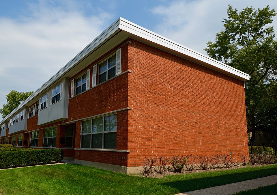
Photograph of Pacesetter Gardens Historic District
Photograph by Boscophotos, CC BY-SA 3.0. Via Wikimedia Commons.

Pacesetter Gardens Historic District

Listed on the National Register of Historic Places in 2005.

From the record

One of 621 National Register listings published here for Cook County · listed in 2005 · category: District.

Sources: the case file at the National Archives · the National Register database, National Park Service · the Wikipedia article
The listing

  • Address. 13604-13736 S. Lowe Ave., Riverdale, 60827
  • When was it listed? November 2005
  • Category. district
  • Township. Calumet township
  • National Register reference number. 05001252 - the number the National Park Service assigned this property when it was listed, and the key its nomination file is catalogued under at the National Archives.

The ground it stands on

104,760 words

The chapter on Calumet Township in History of Cook County, Illinois. From the Earliest Period to the Present Time, published 1884 names Riverdale. This is what it says, exactly as the scans read.

In 1867, the school district was divided, and a Khool built at Kiverdaleby Mr. Kricgcr. of Mine Island; the school directors then 'were F. A. Reich, Jr., Nicklaus Van Heest and Christian Hoeffelman ;' the first teacher was a Mr. Jud<l and the number of pupils about ten. This frame building, of primitive stvle. stood upon the site of the present building. The subject of erecting the present school-house was agitated in 1871, but was opposed, because it was thought tl lat the scholastic necessities of the district did not require so extensive an edifice. It was built, however, in 1S74. The pres. ent directors are Charles E. Relun. F. August Reich and Theodor Hessetnwn j the principal of the school is Andrew S. Hickman ; first assistant, Miss Nellie Matthews; second assistant, Miss L, Haumgartncr ; the number of pupils ahout one hundred and thirty-eight. I he population of Riverdale, according to the' school census, is about six hundred.

Passage source: History of Cook County, Illinois. From the Earliest Period to the Present Time, published 1884.

The lumber interest is represented by the Calumet Lumber Company, whose vard is on the river just east of the bridge : and by Reich \ Williams These latter gentlemen arc the successors of the Riverdale Lumber Company, formed in 1870. with F. A. Reich. Jr.. president ; August Aulich, secretary, and John Anderson, treasurer. In 1881. the company built a planing mill, and in 1883 sold the interest to F. A. Reich, Jr., and Walter S. Williams. The firm own the two-masted schooner "Anna Tomine," whose appearance at the wharf recall* in the minds of old settlers the aspirations tbey indulged in in 1858 ; when the arrival of Peter BattM'l schooner at Riverdale. en route to the prospective city of Portland, now lilue Island, was an event : and filial them with golden visions of being an important adjunct to Portland. The three railroad bridges and the highway bridge are all swing-bridges, so that navigation «s not impeded by them ; the tortuous and short windings of the river are the most serious bar to successful and compensative navigation. Three railroads enter the hamlet - the Illinois Central, the Pittsburg, Chicago &- Si. Louis, and Chicago \ Eastern Illinois.

Passage source: History of Cook County, Illinois. From the Earliest Period to the Present Time, published 1884.

Machine-read from a century-old scan, so expect the errors a machine makes: misspelled names, dropped words, stray characters.

Read the whole chapter on Calumet Township - 104,760 words on its settlement, mills, schools and churches.

Mines and quarries near this property

3 within 5 miles

Regional context, not property-specific evidence. The federal mineral resources record lists 3 workings within 5 miles of Pacesetter Gardens Historic District: 2 past producers, 1 producer. 1 still produces. What was taken out: Clay, Stone, Crushed/Broken. Distance is straight-line from the map coordinates, so a quarry counted here may appear on a neighbouring settlement's page as well.

Where SiteCommodity StatusRecorded
Markham City Dept. of Public WorksStone, Crushed/BrokenPast Producer
Yard No. 22 Clay PitClayPast Producer
Yard R Clay PitClayProducer

Every working recorded in Cook County

Storms near this property

2 since 2013

Regional context, not property-specific evidence. The National Weather Service names Riverdale, the town this property stands in, in 2 storm reports between 2013 and 2026: 1 hail, 1 thunderstorm wind. No death or injury is recorded in these reports. Each account below is quoted exactly as the forecast office filed it, from the NOAA Storm Events Database, and each date opens the federal record of that event.

WhenEvent Place namedHarm What the report says
March 2026Thunderstorm WindRiverdale-Trees were blown down.
January 2013HailRiverdale-no account filed

Every storm recorded in Cook County

Map coverage status

No historic map-sheet match is published for this property yet. That does not mean no map exists. This record needs a coordinate-quality review before it can be joined to a sheet boundary. Browse the county's mapped places while that work is pending.

Listed places nearby

6 within 8 miles

Other National Register properties close enough to walk or drive between, ordered by distance from this one. Both positions come from the same geocoding pass that matched these properties to their map sheets.

Photograph PropertyDistance Listed
Altgeld Gardens-Philip Murray Homes Historic District2.0 miles2022
Joshua P. Young House2.0 miles1982
West Pullman Elementary School2.1 miles2018
Our Lady of the Holy Rosary Church/Holy Rosary Church3.1 miles2024
Palmer Park3.2 miles2007
AVR 6613.4 miles1980

Sources for this property

National Archives recordThe nomination case file for reference 05001252 in Record Group 79.
Wikipedia articleCommunity-written account of this property, licensed CC BY-SA.
Cook CountyAll 621 listed properties in this county.

Provenance

  • Listing record. National Park Service National Register of Historic Places, listed-properties dataset, current to 2026-05-22.
  • Map join. Address geocoded through the United States Census geocoder, then tested against the published boundary of every sheet in the USGS Historical Topographic Map Collection.
  • How this page is made. Listing fields come from federal records; map-sheet coverage is a labelled coordinate-to-boundary calculation, not a source-field claim.
  • Mines and quarries. USGS Mineral Resources Data System (MRDS) https://mrdata.usgs.gov/mrds/ A work of the United States government, no copyright under 17 U.S.C. 105.
  • Storms. NOAA National Centers for Environmental Information, Storm Events Database https://www.ncei.noaa.gov/stormevents/ A work of the United States government, no copyright under 17 U.S.C. 105. Narratives are quoted verbatim from the National Weather Service report and are not edited or summarised.