BlockBefore
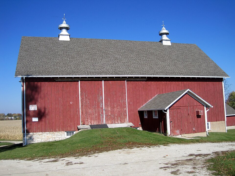
Photograph of McGovney-Yunker Farmstead
Photograph by Teemu08, CC BY-SA 3.0. Via Wikimedia Commons.

McGovney-Yunker Farmstead

Listed on the National Register of Historic Places in 2006.

From the record

One of 38 National Register listings published here for Will County · listed in 2006 · category: District.

Sources: the case file at the National Archives · the National Register database, National Park Service · the Wikipedia article

The listing

  • Listed as. McGovney--Yunker Farmstead - the National Register files a house under its owner's surname.
  • Address. 10824 LaPorte Rd., Mokena, 60448
  • When was it listed? May 2006
  • Category. district
  • Township. Frankfort township
  • National Register reference number. 06000448 - the number the National Park Service assigned this property when it was listed, and the key its nomination file is catalogued under at the National Archives.

Storms near this property

26 since 1994

Regional context, not property-specific evidence. The National Weather Service names Mokena, the town this property stands in, in 26 storm reports between 1994 and 2024: 14 hail, 6 thunderstorm wind, 2 tornado, 1 flash flood. The reports record 2 injuries. Each account below is quoted exactly as the forecast office filed it, from the NOAA Storm Events Database, and each date opens the federal record of that event.

WhenEvent Place namedHarm What the report says
July 1997Tornado (F1)Mokena2 hurtA tornado was observed along a 2-mile path in a northwest to southeast track from about I-80 at 104th Avenue across 191st Street, across Rt 45 into the Arbury Hills Subdivision east of Mokena. The greatest damage occurred on I-80; where a semi was blown off the road and two people were injured in the truck. Just south of I-80, a horse barn was destroyed and another lifted off of the ground. Extensive damage was observed at an RV dealership on 191st street where a 7000 lb. trailer was lifted off of the ground and piled atop two other trailers. Also, along one block of Catalpa Street in the Arbury Hill Subdivision where two houses sustained enough roof damage to be declared unhabitable. There was also extensive tree damage in the subdivision.
May 2024HailMokena-A photo shared on social media showed mostly quarter size hail with the largest hail stones approximately 1.5 inches in diameter.
July 2024Tornado (EF0)Mokena-A tornado with estimated peak winds of 85 mph touched down near Francis Road just west of Front Street, then roughly paralleled Front Street and the railroad tracks through downtown Mokena. Damage along the path consisted of numerous trees, tree limbs and fences blown down, as well as a few instances of structural damage, mainly to roofs of a few buildings. Utility poles and power lines were also damaged. The tornado crossed Route 45 and ended near 96th Avenue.
September 2024Heavy RainMokena-A private weather station reported a storm total rainfall of 2.91 inches.
June 2023Thunderstorm WindMokena-A photo shared on social media showed a tree 12 to 18 inches in diameter snapped.
July 2023Thunderstorm WindMokena-Photos shared via social media showed trees uprooted and large tree limbs snapped at a campground in the Hickory Creek Preserve. Time was estimated using radar.
August 2022Thunderstorm WindMokena-Large tree limbs and debris were blown down near 187th Street.
August 2020Thunderstorm WindMokena-Wind gusts to 65 mph were measured with small tree limbs blown down.
January 2008FloodMokena-Street and field flooding was reported in Mokena with storm total rainfall of 2.53 inches.
August 2007Thunderstorm WindMokena-One tree blown down at Route 30 and Wolf Road.
August 2007Thunderstorm WindMokena-Estimated gust to 60 mph.
July 2006LightningMokena-Lightning struck a house on Forrest Dale Road.
April 2004Flash FloodMokena-Deep standing water at Wolf and LaPorte Rds.
June 1994HailMokena-Winds damaged trees, fences, storage barns. There was minor roof and gutter damage to homes.
February 2017HailMokena-no account filed
August 2017HailMokena-no account filed
August 2014HailMokena-no account filed
May 2013HailMokena-no account filed
June 2013HailMokena-no account filed
June 2012HailMokena-no account filed
April 2006HailMokena-no account filed
June 2006HailMokena-no account filed
May 2003HailMokena-no account filed
April 1996HailMokena-no account filed
February 1996HailMokena-no account filed
April 1994HailMokena-no account filed

Every storm recorded in Will County

Map coverage status

No historic map-sheet match is published for this property yet. That does not mean no map exists. This record needs a coordinate-quality review before it can be joined to a sheet boundary. Browse the county's mapped places while that work is pending.

Listed places nearby

1 within 8 miles

Other National Register properties close enough to walk or drive between, ordered by distance from this one. Both positions come from the same geocoding pass that matched these properties to their map sheets.

Photograph PropertyDistance Listed
Stone Manor4.3 miles1980

Sources for this property

National Archives recordThe nomination case file for reference 06000448 in Record Group 79.
Wikipedia articleCommunity-written account of this property, licensed CC BY-SA.
Will CountyAll 38 listed properties in this county.

Provenance

  • Listing record. National Park Service National Register of Historic Places, listed-properties dataset, current to 2026-05-22.
  • Map join. Address geocoded through the United States Census geocoder, then tested against the published boundary of every sheet in the USGS Historical Topographic Map Collection.
  • How this page is made. Listing fields come from federal records; map-sheet coverage is a labelled coordinate-to-boundary calculation, not a source-field claim.
  • Storms. NOAA National Centers for Environmental Information, Storm Events Database https://www.ncei.noaa.gov/stormevents/ A work of the United States government, no copyright under 17 U.S.C. 105. Narratives are quoted verbatim from the National Weather Service report and are not edited or summarised.