Listed on the National Register of Historic Places in 2018.
From the record
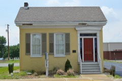
“Glen Carbon Village Hall and Firehouse is a historic building at 180 Summit Avenue in Glen Carbon, Illinois. It was built in 1910 to serve as Glen Carbon's first village hall.”
Wikipedia article Glen Carbon Village Hall and Firehouse, CC BY-SA 4.0.
One of 40 National Register listings published here for Madison County · listed in 2018 · category: Building.
National Register reference number. 100002326 - assigned by the National Park Service when the property was listed.
Mines and
quarries near this property
4 within 5 miles
Regional context, not property-specific
evidence. The federal mineral resources record lists
4 workings within 5 miles of Glen Carbon Village Hall and Firehouse: 1 occurrence, 1 prospect, 1 plant, 1 past producer.
1 still produces. What was taken out: Fire Clay (Refractory), Aluminum, Iron, Silica, Titanium, Sand and Gravel, Construction, Stone. Distance is straight-line from the
map coordinates, so a quarry counted here may appear on a neighbouring
settlement's page as well.
Regional context, not property-specific
evidence. The National Weather Service names
Glen Carbon, the town this property stands in, in 22 storm reports between 1998 and 2025: 15 hail, 5 thunderstorm wind, 1 lightning, 1 tornado.
No death or injury is recorded in these reports. Each account below is quoted exactly as the forecast office
filed it, from the NOAA Storm Events Database, and each date
opens the federal record of that event.
The tornado touched down between Edwardsville and Glen Carbon near the intersection of Ginger Creek Drive and Illinois Route 157. There were several cedar trees uprooted at this location. The tornado continued east-northeast through the Ginger Creek Subdivision to the intersection of Center Grove Road and Illinois Route 159. This is where a metal industrial building sustained roof and siding damage. The tornado also crossed the intersection of Center Grove Road and Troy Road where a few signs of local businesses were damaged and a Home Depot sustained some damage to small preconstructed sheds sitting outside. The tornado continued east-northeast to near the intersection of Gerber Road and Governors Parkway where several houses sustained minor roof and siding damage. The tornado dissipated just beyond this location. The path length of this tornado was 2.4 miles long. Most of the damage along the path was rated EF0 with the maximum intensity rated EF1 for some tree damage and the industrial building damage. The maximum path width was 150 yards.
Thunderstorm winds blew down a twelve inch diameter tree on Clay Street in Troy. Also, numerous large tree limbs were blown down in Glen Carbon and Edwardsville.
No historic map-sheet match is published
for this property yet. That does not mean no map exists. This record needs
a coordinate-quality review before it can be joined to a sheet boundary.
Browse the county's mapped places while that work is
pending.
Listed places nearby
6 within 8 miles
Other National Register properties close
enough to walk or drive between, ordered by distance from this one. Both
positions come from the same geocoding pass that matched these properties
to their map sheets.
Listing record. National Park Service National Register of Historic Places, listed-properties dataset, current to 2026-05-22.
Map join. Address geocoded through the United States Census geocoder, then tested against the published boundary of every sheet in the USGS Historical Topographic Map Collection.
How this page is made. Listing fields come from federal records; map-sheet coverage is a labelled coordinate-to-boundary calculation, not a source-field claim.
Mines and quarries. USGS Mineral Resources Data System (MRDS) https://mrdata.usgs.gov/mrds/ A work of the United States government, no copyright under 17 U.S.C. 105.
Storms. NOAA National Centers for Environmental Information, Storm Events Database https://www.ncei.noaa.gov/stormevents/ A work of the United States government, no copyright under 17 U.S.C. 105. Narratives are quoted verbatim from the National Weather Service report and are not edited or summarised.
 Block