BlockBefore
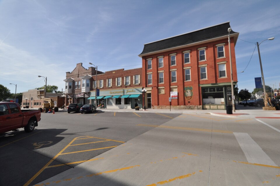
Photograph of Downtown Aledo Historic District
Photograph by Magicpiano, CC BY-SA 4.0. Via Wikimedia Commons.

Downtown Aledo Historic District

Listed on the National Register of Historic Places in 2016.

From the record

“The Downtown Aledo Historic District is a national historic district located in downtown Aledo, Illinois. The district includes 75 contributing buildings and a park.”

Wikipedia article Downtown Aledo Historic District, CC BY-SA 4.0.

One of 12 National Register listings published here for Mercer County · listed in 2016 · category: District.

Sources: the Wikipedia article · the National Register database, National Park Service

The listing

The ground it stands on

53,031 words

The chapter on Mercer Township in History of Mercer County : Together with Biographical Matter, Statistics, Etc., Gathered from Mattter Furnished by the Mercer County Historical Society, Interviews with Old Settlers, County, Township and Other Records, and Extracts from Files of Papers, Pamphlets, and Such Other Sources As Have Been Available : Containing Also a Short History of Henderson County, published 1882 names Aledo. This is what it says, exactly as the scans read.

Much of the township is underlaid with coal of a good quality, but there have, as yet, been but few banks opened, as it generally lies too deep to work with profit. Banks in the northeast part of the township have been run for many years, but seldom at a great profit. Within a few years mines have been opened near Aledo and are still run on a small scale.

Passage source: History of Mercer County : Together with Biographical Matter, Statistics, Etc., Gathered from Mattter Furnished by the Mercer County Historical Society, Interviews with Old Settlers, County, Township and Other Records, and Extracts from Files of Papers, Pamphlets, and Such Other Sources As Have Been Available : Containing Also a Short History of Henderson County, published 1882.

In pursuance of the authority granted by this vote, bonds were issued for the above amount, March 23, 1869, in sums of $100 each, payable ten years after date, and bearing ten per cent interest, payable annually ; the bonds "to be delivered to the company wlien the iron was laid from Galva to Aledo, provided said iron was laid on or before July 1, 1869."

Passage source: History of Mercer County : Together with Biographical Matter, Statistics, Etc., Gathered from Mattter Furnished by the Mercer County Historical Society, Interviews with Old Settlers, County, Township and Other Records, and Extracts from Files of Papers, Pamphlets, and Such Other Sources As Have Been Available : Containing Also a Short History of Henderson County, published 1882.

Machine-read from a century-old scan, so expect the errors a machine makes: misspelled names, dropped words, stray characters.

Read the whole chapter on Mercer Township - 53,031 words on its settlement, mills, schools and churches.

Mines and quarries near this property

1 within 5 miles

Regional context, not property-specific evidence. The federal mineral resources record lists 1 working within 5 miles of Downtown Aledo Historic District: 1 past producer. None of them still produces. What was taken out: Stone. Distance is straight-line from the map coordinates, so a quarry counted here may appear on a neighbouring settlement's page as well.

Where SiteCommodity StatusRecorded
Mercer County PitStonePast Producer

Every working recorded in Mercer County

Storms near this property

40 since 1993

Regional context, not property-specific evidence. The National Weather Service names Aledo, the town this property stands in, in 40 storm reports between 1993 and 2025: 24 thunderstorm wind, 8 hail, 4 tornado, 1 lightning. The reports record 1 death. Each account below is quoted exactly as the forecast office filed it, from the NOAA Storm Events Database, and each date opens the federal record of that event.

WhenEvent Place namedHarm What the report says
June 1997LightningAledo1 killedno account filed
April 2003Tornado (F1)Aledo$500,000Damaged farm buildings
June 2010Flash FloodAledo$50,000Heavy rains resulted in flash flooding in Aledo, IL during the evening of June 18. Several streets were flooded and Highway 17 had water covering it.
April 2003Tornado (F0)Aledo$50,000traveled through open country
May 2003Tornado (F0)Aledo$50,000no account filed
April 2006HailAledo$20,000Window cracked with hole the size of a half dollar; pea to half dollar size hail during the storm.
April 2006Thunderstorm WindAledo$10,000Trees/limbs and power lines down across the city.
March 2006Thunderstorm WindAledo$5,000Trees and power lines down
June 2000Thunderstorm WindAledo$1,000no account filed
August 2025Thunderstorm WindAledo-Trees and power lines were blown down in town.
February 2024HailAledo-The hail was half dollar to silver dollar size.
February 2024HailAledo-Photo received through social media.
April 2024Thunderstorm WindAledo-A public report of power poles down near Highway 17and 200th Street. The time of the event was estimated using radar.
April 2024Thunderstorm WindAledo-An NWS Storm Survey found that a portion of the roof was torn off the Community Bible Fellowship Church.
August 2023HailAledo-Broadcast media relayed a report of a mix of quarter to half dollar size hail.
March 2022Thunderstorm WindAledo-A trained spotter reported a thunderstorm wind gust of 60 MPH.
August 2022Tornado (EFU)Aledo-Eyewitness reports along with video and photographic evidence from storm chasers support an intermittent tornado path of nearly 3 miles. There are also reports of minor crop damage associated with tornado. Times were based on detailed information from chasers. With no observable damage to assess, this tornado is rated an EF-U.
April 2021Thunderstorm WindAledo-A trained spotter reported thunderstorm wind damage to a farm outbuilding south of Aledo. Pictures via social media show part of a wall blown out, but the barn was open to one side and the other wall is partially covered. Time of the event was estimated using radar.
July 2020Thunderstorm WindAledo-Downed power pole reported.
July 2020Thunderstorm WindAledo-A large pine tree was uprooted along Highway 94 south of Aledo.
August 2018Thunderstorm WindAledo-Law enforcement relayed a report of trees down in Aledo.
September 2018Thunderstorm WindAledo-Local law enforcement reported a few trees and power lines down.
July 2017Thunderstorm WindAledo-The county emergency manager reported a couple of trees were down.
July 2017Thunderstorm WindAledo-Local law enforcement reported a tree was down.
July 2016Thunderstorm WindAledo-The emergency manager reported furniture blown around and a semi trailer was blown over at the Mercer County Fair in Aledo. Some trees were also blown down in town. Winds were estimated around 60 MPH.
June 2008HailAledo-Penny to nickel-sized hail fell just northeast of Aledo, IL around 6:45 pm June 14.
March 2007Thunderstorm WindAledo-Sheriffs department reported at least one power pole blown down just north of Aledo, and numerous small branches down around the Aledo area.
March 2002Thunderstorm WindAledo-A homestead in rural Aledo suffered heavy damage. High winds shattered windows and destroyed a barn, three empty grain storage bins, a fence, several dog houses and a children's swing set.
June 2002Thunderstorm WindAledo-A wooden swingset was blown over, and a trampoline was picked up and blown into a field.
May 2002FloodAledo-Minor flooding reported on some secondary roads.
June 1999Thunderstorm WindAledo-Several tree limbs downed. A large tree was blown down onto a baseball field.
March 1998Thunderstorm WindAledo-Numerous trees and power lines were downed.
July 1997Thunderstorm WindAledo-Trees and power lines down.
June 1997Thunderstorm WindAledo-Trees down across route 94.
August 1993Thunderstorm WindAledo-Winds knocked out windows and damaged a gutter at a house. Eight trees were uprooted, farm buildings were damaged.
April 2024HailAledo-no account filed
August 2023HailAledo-no account filed
April 2003Funnel CloudAledo-no account filed
June 2002HailAledo-no account filed
April 1997Thunderstorm WindAledo-no account filed

Every storm recorded in Mercer County

Map coverage status

No historic map-sheet match is published for this property yet. That does not mean no map exists. This record needs a coordinate-quality review before it can be joined to a sheet boundary. Browse the county's mapped places while that work is pending.

Listed places nearby

3 within 8 miles

Other National Register properties close enough to walk or drive between, ordered by distance from this one. Both positions come from the same geocoding pass that matched these properties to their map sheets.

Photograph PropertyDistance Listed
Mercer County Courthouse0.1 miles1982
Mercer County Jail0.1 miles1997
Mercer County Fairgrounds1.1 miles1997

Sources for this property

National Archives recordThe nomination case file for reference 16000328 in Record Group 79.
Wikipedia articleCommunity-written account of this property, licensed CC BY-SA.
Mercer CountyAll 12 listed properties in this county.

Provenance

  • Listing record. National Park Service National Register of Historic Places, listed-properties dataset, current to 2026-05-22.
  • Map join. Address geocoded through the United States Census geocoder, then tested against the published boundary of every sheet in the USGS Historical Topographic Map Collection.
  • How this page is made. Listing fields come from federal records; map-sheet coverage is a labelled coordinate-to-boundary calculation, not a source-field claim.
  • Mines and quarries. USGS Mineral Resources Data System (MRDS) https://mrdata.usgs.gov/mrds/ A work of the United States government, no copyright under 17 U.S.C. 105.
  • Storms. NOAA National Centers for Environmental Information, Storm Events Database https://www.ncei.noaa.gov/stormevents/ A work of the United States government, no copyright under 17 U.S.C. 105. Narratives are quoted verbatim from the National Weather Service report and are not edited or summarised.