BlockBefore
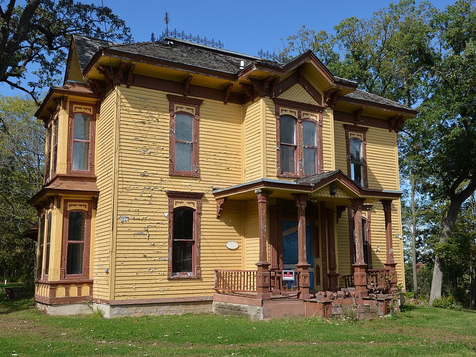
Photograph of Rockton Historic District
Photograph by Boscophotos, CC BY-SA 3.0. Via Wikimedia Commons.

Rockton Historic District

Listed on the National Register of Historic Places in 1978.

From the record

“The Rockton Historic District is a national historic district which encompasses much of the village of Rockton, Illinois. The district includes 208 buildings, most of which are residential.”

Wikipedia article Rockton Historic District, CC BY-SA 4.0.

One of 43 National Register listings published here for Winnebago County · listed in 1978 · category: District.

Sources: the Wikipedia article · the case file at the National Archives · the National Register database, National Park Service

The listing

The ground it stands on

22,442 words

The chapter on Rockton Township in The History of Winnebago County, Illinois : Its Past and Present, Containing ... a Biographical Directory of Its Citizens, War Record of Its Volunteers in the Late Rebellion, General and Local Statistics ... History of the Northwest, History of Illinois ... Etc, published 1877 names Rockton. This is what it says, exactly as the scans read.

Thatcher Blake, Ephraim Sumner, Charles "Works, Phineas Churchill, Thomas Lake, and Ephraim Wjmian are living in Kockford, or its immediate vicinity. Thomas B. Talcott, Isaac Adams of Rockton, and A. C. Gleason live at Cherry Yalley; Simon P. Doty, at Belvidere; Harlyn Sliattuck, at Shattuck's Grove, Boone County (P. O. Belvidere); H. M. Wattles (at last authentic account, one year ago), in Minnesota; W. R. Wheeler, Colorado Springs, Colorado; P. M. Waller, Charles City, Iowa; Israel Morrill, Minnesota; David Caswell, Iowa.

Passage source: The History of Winnebago County, Illinois : Its Past and Present, Containing ... a Biographical Directory of Its Citizens, War Record of Its Volunteers in the Late Rebellion, General and Local Statistics ... History of the Northwest, History of Illinois ... Etc, published 1877.

Machine-read from a century-old scan, so expect the errors a machine makes: misspelled names, dropped words, stray characters.

Read the whole chapter on Rockton Township - 22,442 words on its settlement, mills, schools and churches.

Fires near this property

17 since 2018

Regional context, not property-specific evidence. The federal wildfire occurrence database lists 17 fires within 5 miles of Rockton Historic District between 2018 and 2020, burning about 12 acres in total. 1 started naturally. 1 was recorded as arson. Distance is straight-line from the map coordinates, so a fire counted here may appear on a neighbouring settlement's page as well.

Reported cause Fires
Missing data/not specified/undetermined10
Smoking5
Arson/incendiarism1
Natural1

The most recent of them, most recent first, with the day each was reported and the service that recorded it.

DateCause SizeReported by Name on the report
5 July 2020Missing data/not specified/undetermined1.0 acresWisconsin Department of Natural Resources201883
26 July 2018Smoking1.0 acresWisconsin Department of Natural Resources183149
4 June 2018Smokingunder an acreWisconsin Department of Natural Resources182327
20 June 2020Missing data/not specified/undetermined1.0 acresWisconsin Department of Natural Resources201732
18 June 2018Missing data/not specified/undeterminedunder an acreWisconsin Department of Natural Resources182542
28 May 2018Smokingunder an acreWisconsin Department of Natural Resources182208
18 May 2018Smokingunder an acreWisconsin Department of Natural Resources182040
5 April 2018Arson/incendiarism1.0 acresWisconsin Department of Natural Resources181387

Every fire recorded in Winnebago County

Mines and quarries near this property

10 of 18 shown

Regional context, not property-specific evidence. The federal mineral resources record lists 18 workings within 5 miles of Rockton Historic District: 14 past producers, 3 producers, 1 plant. 4 still produce. What was taken out: Stone, Crushed/Broken, Sand and Gravel, Construction. Distance is straight-line from the map coordinates, so a quarry counted here may appear on a neighbouring settlement's page as well.

Where SiteCommodity StatusRecorded
Can-Tex Industries Aggregate PitSand and Gravel, ConstructionPast Producer
Durgon PitSand and Gravel, ConstructionPast Producer
Ellis PitSand and Gravel, ConstructionPast Producer
General Dynamics PitSand and Gravel, ConstructionPast Producer
Illinois Wisconsin Sand & GravelSand and Gravel, ConstructionProducer
Kelley Pit & MillSand and Gravel, ConstructionPlant
Manley PitSand and Gravel, ConstructionPast Producer
Turtle PitSand and Gravel, ConstructionPast Producer
Black QuarryStone, Crushed/BrokenProducer
E. Sharp QuarryStone, Crushed/BrokenPast Producer

Every working recorded in Winnebago County

Storms near this property

25 since 1996

Regional context, not property-specific evidence. The National Weather Service names Rockton, the town this property stands in, in 25 storm reports between 1996 and 2026: 13 thunderstorm wind, 7 hail, 2 flash flood, 2 funnel cloud. No death or injury is recorded in these reports. Each account below is quoted exactly as the forecast office filed it, from the NOAA Storm Events Database, and each date opens the federal record of that event.

WhenEvent Place namedHarm What the report says
June 2014Thunderstorm WindRockton$25,000A garage collapsed due to severe winds.
June 2007Thunderstorm WindRockton$20,000Trees and power lines were blown down. Siding blown off a house. A deck was damaged from a grill that was blown over and a hard top cover was blown off a pool.
July 2008Thunderstorm WindRockton$5,000Patio furniture and a barbeque grill were blown around and damaged. Wind damage was reported to siding and gutters of a few houses.
May 2013Thunderstorm WindRockton$1,000Power lines were blown down and utility poles were leaning over. Shredded tree branches were reported near Hononegah Road.
June 2007Thunderstorm WindRockton$1,000Tree limbs and powerlines were blown down at North Main Street and Route 2 and at 35th Street and Old Gate Road.
July 2025Funnel CloudRockton-A funnel cloud was reported near Rockton moving to the northeast.
August 2025Flash FloodRockton-Flash flooding impacted portions of far northeast Winnebago County, specifically in the vicinity of Rockton. Street flooding was reported near Rockton Rd and Dorr Rd with floodwater reaching into yards. Street flooding was also reported via mPing along I-39 south of McCurry Rd. A private weather station on the east side of Rockton recorded 4.5 of rainfall. Two others nearby recorded closer to 3.5.
May 2024Thunderstorm WindRockton-Tree damage was reported west of Rockton.
August 2021Thunderstorm WindRockton-A photo shared on social media showed a large tree limb blown down.
July 2021Funnel CloudRockton-Several high based funnel clouds were observed from Route 2 near Rockton.
November 2020HailRockton-A photo of vinyl siding of a home showed damaged by wind driven hail. The hail size was estimated.
November 2020Thunderstorm WindRockton-Wind gusts were estimated to 70 mph.
April 2011HailRockton-Penny to nickel size hail was reported in Rockton.
August 2011Thunderstorm WindRockton-Several trees were blown down.
June 2007Flash FloodRockton-Several roads closed with up to 3 feet of standing water.
May 2005HailRockton-Hail ranging from the size of nickels to golfballs fell across far northeast Winnebago County.
May 2003Tornado (F0)Rockton-A tornado touched down west of Rockton near the bend in the Rock River and continued southeast, and lifted northwest of Roscoe. A gas station near 151 and Elevator Road had damage to glass and a wall. No other damage was reported.
September 2001Thunderstorm WindRockton-One tree blown down.
July 1999Thunderstorm WindRockton-Trees and utility poles were blown down by 60mph wind gusts. A mobile home was blown across Illinois Route 251.
April 2026HailRockton-no account filed
April 2023HailRockton-no account filed
March 2006HailRockton-no account filed
July 2003HailRockton-no account filed
July 2003Thunderstorm WindRockton-no account filed
April 1996Thunderstorm WindRockton-no account filed

Every storm recorded in Winnebago County

Map coverage status

No historic map-sheet match is published for this property yet. That does not mean no map exists. This record needs a coordinate-quality review before it can be joined to a sheet boundary. Browse the county's mapped places while that work is pending.

Listed places nearby

3 within 8 miles

Other National Register properties close enough to walk or drive between, ordered by distance from this one. Both positions come from the same geocoding pass that matched these properties to their map sheets.

Photograph PropertyDistance Listed
H.D. Jameson House0.6 miles2003
Macktown Historic District0.8 miles1978
Chicago & North Western Railway Stone Arch Bridge4.7 miles1993

Sources for this property

National Archives recordThe nomination case file for reference 78001202 in Record Group 79.
Wikipedia articleCommunity-written account of this property, licensed CC BY-SA.
Winnebago CountyAll 43 listed properties in this county.

Provenance

  • Listing record. National Park Service National Register of Historic Places, listed-properties dataset, current to 2026-05-22.
  • Map join. Address geocoded through the United States Census geocoder, then tested against the published boundary of every sheet in the USGS Historical Topographic Map Collection.
  • How this page is made. Listing fields come from federal records; map-sheet coverage is a labelled coordinate-to-boundary calculation, not a source-field claim.
  • Wildfire. Short, Karen C. 2022. Spatial wildfire occurrence data for the United States, 1992-2020 [FPA_FOD_20221014]. 6th Edition. Fort Collins, CO: Forest Service Research Data Archive. https://doi.org/10.2737/RDS-2013-0009.6 Collected with United States Government funding and usable without additional permissions or fees.
  • Mines and quarries. USGS Mineral Resources Data System (MRDS) https://mrdata.usgs.gov/mrds/ A work of the United States government, no copyright under 17 U.S.C. 105.
  • Storms. NOAA National Centers for Environmental Information, Storm Events Database https://www.ncei.noaa.gov/stormevents/ A work of the United States government, no copyright under 17 U.S.C. 105. Narratives are quoted verbatim from the National Weather Service report and are not edited or summarised.