BlockBefore
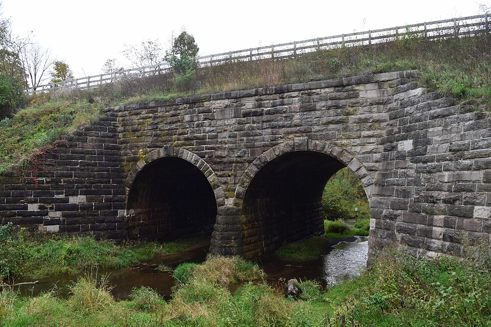
Photograph of Chicago & North Western Railway Stone Arch Bridge
Photograph by TheCatalyst31, CC0 1.0. Via Wikimedia Commons.

Chicago & North Western Railway Stone Arch Bridge

Listed on the National Register of Historic Places in 1993.

From the record

“The Chicago & North Western Railway Stone Arch Bridge, also known as the Kinnikinnick Creek Railway Bridge, is a historic Chicago and North Western Railway bridge that crosses South Kinnikinnick Creek east of Roscoe, Illinois. The bridge was built in 1882 to replace a wooden bridge; the line it was on opened in 1853 as part of the Galena and Chicago Union Railroad and originally connected Belvidere, Illinois and Beloit, Wisconsin.”

Wikipedia article Chicago & North Western Railway Stone Arch Bridge, CC BY-SA 4.0.

One of 43 National Register listings published here for Winnebago County · listed in 1993 · category: Structure.

Sources: the Wikipedia article · the case file at the National Archives · the National Register database, National Park Service
The listing

  • What is counted as historic. The nomination lists 1 structure as contributing to the listing.
  • Address. 0.6 mi. E of IL 251, 0.6 mi. W of I-90 and 0.2 mi. S of Burr Oak Rd., Roscoe, 61073
  • When was it listed? August 1993
  • Category. structure
  • Township. Roscoe township
  • National Register reference number. 93000840 - the number the National Park Service assigned this property when it was listed, and the key its nomination file is catalogued under at the National Archives.

The ground it stands on

2,611 words

The chapter on Roscoe Township in The History of Winnebago County, Illinois : Its Past and Present, Containing ... a Biographical Directory of Its Citizens, War Record of Its Volunteers in the Late Rebellion, General and Local Statistics ... History of the Northwest, History of Illinois ... Etc, published 1877 names Roscoe. This is what it says, exactly as the scans read.

Roscoe is the northeast township of the county, bounded on the north by the Wisconsin State line. The first permanent settlement was made in the fall of 1835, but some Indian traders had previously erected and occupied cabins in the grove on Section 32. The remains of the cabins and the track made by the wagon train that accompanied General Atkins in his campaign against the Black Hawk Indians in June, 1832, were still clearly defined when the first settlers came. The maple trees also showed that the Indians had tapped them for sugar- making purposes. August 3, 1835, R. J. Cross, of Coldwater, Mich., and Colonel Yon Hovenburg, with a Pottawatomie Indian for a guide, came into the township from Milwaukee. Col. Yon Hovenburg returned to Michigan; Mr. Cross bought a claim of Lavec, an employee of Stephen Mack, upon which he subsequently settled. This claim was covered by the grove in the southwest quarter of Section 32.

Passage source: The History of Winnebago County, Illinois : Its Past and Present, Containing ... a Biographical Directory of Its Citizens, War Record of Its Volunteers in the Late Rebellion, General and Local Statistics ... History of the Northwest, History of Illinois ... Etc, published 1877.

In September of the same year, Elijah H. Brown, James B. Lee and Wilham Mead came in from La Porte County, Indiana, and selected clainas. Brown built a house on the left bank of Rock river, a little above the mouth of the north branch of the Kinikinick, on the northeast quarter of Section 32, which was the first house built in what subsequently became Koscoe township. In the winter of 1835-6, Messrs. Brown, Lee, Cross and Logan were the only settlers in that part of the county. Mr. Cross had the only horse team in the settlement, and it was kept on the road nearly all the time when the roads were passable, hauling flour and groceries from Chicago. Mr. Reynolds, of Rolling Prairie, La Porte Count}'^, Indiana, bought Lee's claim, and was the first blacksmith to forge and hammer in that precinct, and in the winter of 1836-7 there were only eight families. Until a postoffice was established at Beloit, the settlers got their mail matter at Chicago; but in the spring of 1837, a post-office was established at Ruscoe, and R. M. P. Abell was appointed post-master. In 1887, Henry Abell and his son, Franklin, built a saw-mill, the first in the neighborhood. This mill was built at the mouth of the north branch of the Kinikinick, where they proposed to build a village, which they named Roscoe, in honor of Roscoe, aji eminent English historian, and when the names of townships were established in 1850, the name was given to the municipality. Under the new order, the first town meeting was held at the house of James K. Knowland, April 1, 1850. J. G. Prentiss was chosen Moderator; John J. Rhodes was elected Supervisor, and Nathaniel Howland, Town Clerk. Mr. Rhodes was continued in office for seven years, and until his death. At the first town meeting or election, 180 votes were polled.

Passage source: The History of Winnebago County, Illinois : Its Past and Present, Containing ... a Biographical Directory of Its Citizens, War Record of Its Volunteers in the Late Rebellion, General and Local Statistics ... History of the Northwest, History of Illinois ... Etc, published 1877.

Machine-read from a century-old scan, so expect the errors a machine makes: misspelled names, dropped words, stray characters.

Read the whole chapter on Roscoe Township - 2,611 words on its settlement, mills, schools and churches.

Mines and quarries near this property

10 of 25 shown

Regional context, not property-specific evidence. The federal mineral resources record lists 25 workings within 5 miles of Chicago & North Western Railway Stone Arch Bridge: 19 past producers, 5 producers, 1 plant. 6 still produce. What was taken out: Sand and Gravel, Construction, Stone, Crushed/Broken. Distance is straight-line from the map coordinates, so a quarry counted here may appear on a neighbouring settlement's page as well.

Where SiteCommodity StatusRecorded
Black QuarryStone, Crushed/BrokenProducer
Cooling QuarryStone, Crushed/BrokenProducer
Foss QuarryStone, Crushed/BrokenPast Producer
Genestra QuarryStone, Crushed/BrokenPast Producer
H. Webster QuarryStone, Crushed/BrokenPast Producer
Kelley Quarry Porter & SonsStone, Crushed/BrokenPast Producer
Peterson QuarryStone, Crushed/BrokenPast Producer
Porter Bros. Swanson Road QuarryStone, Crushed/BrokenProducer
R. Black QuarryStone, Crushed/BrokenPast Producer
Swanson QuarryStone, Crushed/BrokenPast Producer

Every working recorded in Winnebago County

Storms near this property

24 since 2003

Regional context, not property-specific evidence. The National Weather Service names Roscoe, the town this property stands in, in 24 storm reports between 2003 and 2024: 10 thunderstorm wind, 6 hail, 4 flood, 2 heavy rain. No death or injury is recorded in these reports. Each account below is quoted exactly as the forecast office filed it, from the NOAA Storm Events Database, and each date opens the federal record of that event.

WhenEvent Place namedHarm What the report says
June 2008FloodRoscoe$6,000,000no account filed
July 2010LightningRoscoe$50,000Lightning struck an underground gas line on Wild Deer Trail and a second underground gas line on Huntsboro Lane. Lightning also struck a home on Pin Oak causing a fire to start in the garage.
March 2009Thunderstorm WindRoscoe$50,000Extensive tree damage was reported in Roscoe. The roof of one home was damaged, as well as a fence. A second home sustained roof and siding damage. Power lines were also blown down.
June 2014Thunderstorm WindRoscoe$10,000A few trees were uprooted and a branch fell through a home.
May 2011Thunderstorm WindRoscoe$5,000Estimated 60 mph wind gusts in the town of Roscoe downed tree branches, bent a Dairy Queen flagpole in half, and caused damage at the Roscoe Fire Department including their training facility.
July 2024Thunderstorm WindRoscoe-Tree damage was reported near Roscoe.
July 2022Heavy RainRoscoe-A private weather station measured 3.01 inches of rain in just over one and half hours.
August 2021Thunderstorm WindRoscoe-A large tree was uprooted.
November 2020Thunderstorm WindRoscoe-Wind gusts were estimated to 70 mph. Numerous large tree limbs were blown down.
November 2020HailRoscoe-Multiple reports of quarter size hail were received from the Roscoe area.
September 2018FloodRoscoe-A park was reported flooded in Roscoe.
June 2018Heavy RainRoscoe-Rainfall of 1.50 inches was measured in one hour.
May 2017Thunderstorm WindRoscoe-Multiple large trees were uprooted.
August 2009Thunderstorm WindRoscoe-Several trees were blown down in Roscoe.
April 2008FloodRoscoe-One to two feet of standing water was reported at Edgemere Terrace.
July 2007Flash FloodRoscoe-East Rock Road closed due to flooding.
July 2006Thunderstorm WindRoscoe-Large tree limb blown down.
April 2023HailRoscoe-no account filed
April 2013HailRoscoe-no account filed
November 2013HailRoscoe-no account filed
January 2008HailRoscoe-no account filed
July 2008FloodRoscoe-no account filed
June 2004HailRoscoe-no account filed
July 2003Thunderstorm WindRoscoe-no account filed

Every storm recorded in Winnebago County

Map coverage status

No historic map-sheet match is published for this property yet. That does not mean no map exists. This record needs a coordinate-quality review before it can be joined to a sheet boundary. Browse the county's mapped places while that work is pending.

Listed places nearby

4 within 8 miles

Other National Register properties close enough to walk or drive between, ordered by distance from this one. Both positions come from the same geocoding pass that matched these properties to their map sheets.

Photograph PropertyDistance Listed
Rockton Historic District4.7 miles1978
H.D. Jameson House5.1 miles2003
Macktown Historic District5.2 miles1978
Kenneth and Phyllis Laurent House8.0 miles2012

Sources for this property

National Archives recordThe nomination case file for reference 93000840 in Record Group 79.
Wikipedia articleCommunity-written account of this property, licensed CC BY-SA.
Winnebago CountyAll 43 listed properties in this county.

Provenance

  • Listing record. National Park Service National Register of Historic Places, listed-properties dataset, current to 2026-05-22.
  • Map join. Address geocoded through the United States Census geocoder, then tested against the published boundary of every sheet in the USGS Historical Topographic Map Collection.
  • How this page is made. Listing fields come from federal records; map-sheet coverage is a labelled coordinate-to-boundary calculation, not a source-field claim.
  • Mines and quarries. USGS Mineral Resources Data System (MRDS) https://mrdata.usgs.gov/mrds/ A work of the United States government, no copyright under 17 U.S.C. 105.
  • Storms. NOAA National Centers for Environmental Information, Storm Events Database https://www.ncei.noaa.gov/stormevents/ A work of the United States government, no copyright under 17 U.S.C. 105. Narratives are quoted verbatim from the National Weather Service report and are not edited or summarised.