
BlockBefore
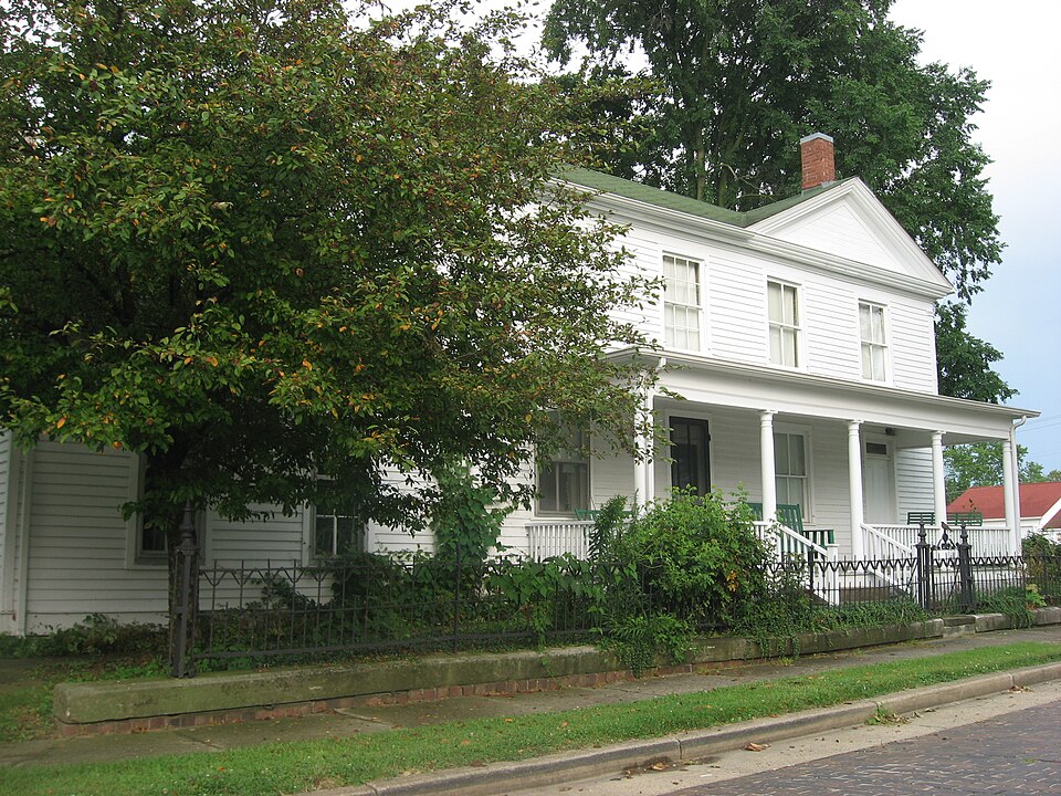
Photograph of Dr. Hiram Rutherford House and Office
Photograph by Nyttend, Public domain. Via Wikimedia Commons.

Dr. Hiram Rutherford House and Office

Listed on the National Register of Historic Places in 1982.

From the record

“Hiram Rutherford House and Office is a historic house located at 14 S. Hiram Rutherford, a doctor who settled in Oakland in 1840.”

Wikipedia article Dr. Hiram Rutherford House and Office, CC BY-SA 4.0.

One of 24 National Register listings published here for Coles County · listed in 1982 · category: Building.

Sources: the Wikipedia article · the case file at the National Archives · the National Register database, National Park Service
The listing

  • What is counted as historic. The nomination lists 2 buildingss, 1 structure as contributing to the listing.
  • Listed as. Rutherford, Dr. Hiram, House and Office - the National Register files a house under its owner's surname.
  • Address. 14 S. Pike St., Oakland, 61943
  • When was it listed? June 1982
  • Category. building
  • Township. East Oakland township
  • National Register reference number. 82002523 - the number the National Park Service assigned this property when it was listed, and the key its nomination file is catalogued under at the National Archives.

The ground it stands on

2,133 words

The chapter on East Oakland Township in The History of Coles County, Illinois ... Map of Coles County; History of Illinois ... History of Northwest ... Constitution of the United States, Miscellaneous Matters, &c., &c, published 1879 names Oakland. This is what it says, exactly as the scans read.

This enterprising little village is situated on the Illinois Midland Railroad, about twenty miles northwest from Paris. It was surveyed and laid out by Reubin Canterbury, County Surveyor, for Madison Ashmore, on the 12th of May, 1835. James Ashmore built the first residence in the village. McCord built a residence soon after the one built by Ashmore. Some say that McCord's was built before the village was laid out, while others hold to the fact as given above. The first store was kept by a man named McCleland Another was opened very soon after McCleland's, by a Mr. Trembly, but neither lasted long, and both "broke" in the business. Says the ^eraM reminiscence : "For the next four years, no goods of any kind, save what a peddler might bring in, were sold in Oakland. Our trading had to be done in Charleston or Paris. Not a spool nor a thread, nor even a pin, was to be had short of these towns. There was nothing here to buy goods with. Four-year-old steers went at $10 per head, and the only good horse we ever owned we bought for $50. Corn for many years never rated above 10 cents per bushel, and then was not considered a merchantable article."

Passage source: The History of Coles County, Illinois ... Map of Coles County; History of Illinois ... History of Northwest ... Constitution of the United States, Miscellaneous Matters, &c., &c, published 1879.

The first tavern in Oakland was kept by Daniel Payne, soon after the laying-out of the village, and the next, perhaps, was kept by 'Squire Pemberton. The village at present has two first-rate hotels - the Oakland House, kept by H. A. Frederick, and the Union Hotel, by Mrs. Jones. The first post office was kept by McCleland, elsewhere mentioned as the first merchant. The present Postmaster is L. C. Thornton. The first blacksmith in the village was a man named Maxon, and his shop was a counterpart of that described by Longfellow, except that instead of the "spreading chestnut-tree" it stood under a spreading oak-tree. We are informed that it consisted mainly of a bellows and anvil, rigged up under an oak tree, and that there was no building belonging to it. The first doctor to practice in this section was of the name of Montague, but of him we learned but little. The next was perhaps Dr. H. Rutherford, who came here in 1840, and practiced the healing profession until he amassed quite a snug fortune, and physicians became so plenty that he could retire from a long life of laborious work.

Passage source: The History of Coles County, Illinois ... Map of Coles County; History of Illinois ... History of Northwest ... Constitution of the United States, Miscellaneous Matters, &c., &c, published 1879.

Machine-read from a century-old scan, so expect the errors a machine makes: misspelled names, dropped words, stray characters.

Read the whole chapter on East Oakland Township - 2,133 words on its settlement, mills, schools and churches.

Storms near this property

18 since 1998

Regional context, not property-specific evidence. The National Weather Service names Oakland, the town this property stands in, in 18 storm reports between 1998 and 2025: 9 thunderstorm wind, 6 hail, 3 flash flood. No death or injury is recorded in these reports. Each account below is quoted exactly as the forecast office filed it, from the NOAA Storm Events Database, and each date opens the federal record of that event.

WhenEvent Place namedHarm What the report says
April 2020Thunderstorm WindOakland$75,000Several small tree branches were blown down and shingles were blown off roofs.
May 2013Thunderstorm WindOakland$60,000A pole barn was damaged and shingles were torn off homes nearby.
May 2008Thunderstorm WindOakland$30,000Numerous trees and tree limbs were blown down. The roof was blown off an outbuilding.
June 2008Thunderstorm WindOakland$30,000Numerous trees, tree limbs, and power lines were blown down.
July 2008Thunderstorm WindOakland$25,000Numerous trees were blown down in Oakland, causing power outages from Oakland to Ashmore.
June 2025Thunderstorm WindOakland-A large tree was uprooted and blown onto a house, resulting in structural damage. A photo of the damage was shared via social media.
June 2023Thunderstorm WindOakland-A grain bin was destroyed.
August 2016Flash FloodOakland-Heavy downpours flooded several roads in northeast Coles County, including the main county highway between Oakland and Ashmore which was impassable due to flowing water. A small part of Illinois Route 133 east of Oakland was also flooded. Several small creeks and streams feeding into the Little Embarras River also flooded very quickly.
July 2010Flash FloodOakland-Thunderstorms with heavy rainfall rates of 1.50 per hour for at least two hours produced flash flooding in much of northeast Coles County. Many rural roads had six inches or more of flowing water during the early evening hours.
June 2007Thunderstorm WindOakland-A few trees and tree limbs were blown down.
July 2001Flash FloodOakland-Roads were reported flooded in Oakland, with a local resident reporting over 8 inches of new rainfall.
July 1998Thunderstorm WindOakland-Trees, tree limbs, and power lines were blown down in Oakland as a severe thunderstorm moved through the area. On one building a portion of the tin roof was blown off and one tree fell against a home causing little damage. No injuries were reported and no damage estimate was available.
July 2023HailOakland-no account filed
May 2016HailOakland-no account filed
October 2007HailOakland-no account filed
August 2000HailOakland-no account filed

Every storm recorded in Coles County

Map coverage status

No historic map-sheet match is published for this property yet. That does not mean no map exists. This record needs a coordinate-quality review before it can be joined to a sheet boundary. Browse the county's mapped places while that work is pending.

Listed places nearby

1 within 8 miles

Other National Register properties close enough to walk or drive between, ordered by distance from this one. Both positions come from the same geocoding pass that matched these properties to their map sheets.

Photograph PropertyDistance Listed
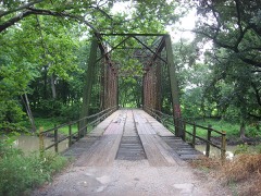
Airtight Bridge7.5 miles1981

Sources for this property

National Archives recordThe nomination case file for reference 82002523 in Record Group 79.
Wikipedia articleCommunity-written account of this property, licensed CC BY-SA.
Coles CountyAll 24 listed properties in this county.

Provenance

  • Listing record. National Park Service National Register of Historic Places, listed-properties dataset, current to 2026-05-22.
  • Map join. Address geocoded through the United States Census geocoder, then tested against the published boundary of every sheet in the USGS Historical Topographic Map Collection.
  • How this page is made. Listing fields come from federal records; map-sheet coverage is a labelled coordinate-to-boundary calculation, not a source-field claim.
  • Storms. NOAA National Centers for Environmental Information, Storm Events Database https://www.ncei.noaa.gov/stormevents/ A work of the United States government, no copyright under 17 U.S.C. 105. Narratives are quoted verbatim from the National Weather Service report and are not edited or summarised.