BlockBefore
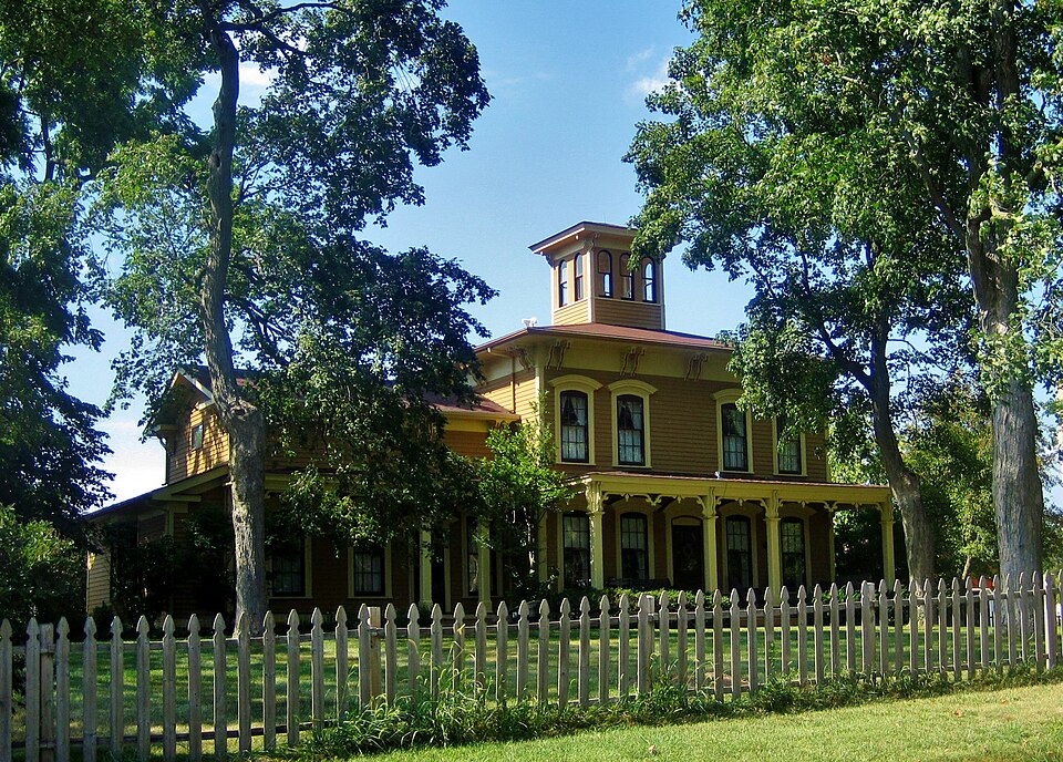
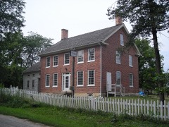
Photograph of Stearns-Wadsworth House
Photograph by Teemu08, CC BY-SA 3.0. Via Wikimedia Commons.

Stearns-Wadsworth House

Listed on the National Register of Historic Places in 1982.

From the record

“The Stearns-Wadsworth House is a historic Italianate residence in Bald Mound, Blackberry Township, an unincorporated settlement near Batavia, Illinois. Stearns, a farmer who owned the most land in the township.”

Wikipedia article Stearns-Wadsworth House, CC BY-SA 4.0.

One of 86 National Register listings published here for Kane County · listed in 1982 · category: Building.

Sources: the Wikipedia article · the case file at the National Archives · the National Register database, National Park Service
The listing

  • What is counted as historic. The nomination lists 1 building as contributing to the listing.
  • Address. 1 S. 570 Bliss Rd., Batavia, 60510
  • When was it listed? March 1982
  • Category. building
  • Township. Blackberry township
  • Architectural style. Italianate architecture
  • National Register reference number. 82002547 - the number the National Park Service assigned this property when it was listed, and the key its nomination file is catalogued under at the National Archives.

The ground it stands on

1,749 words

The chapter on Blackberry Township in History of Kane County, Ill., published 1908 names Batavia. This is what it says, exactly as the scans read.

In the "305 the pioneers had to go to Naperville for a mill, but in time Mr. Boardman put up his mill near Batavia. The first road was the one leading to Naperville. which was opened by John Griggs and the Lees in driving back and forth to the mill. John Griggs. Sr., was elected the first justice of the peace in what was then Washington precinct, of which Plato was a part. In 1840 J. S. Lee was elected justice of the peace. In 1836 Dr. L. S. Tyler staked a claim upon the land which afterward became the \illage and postoffice of Udina. He was from Orange county, Vermont. John Ranstead, father of J. W. Ranstead, of Elgin, took up a claim here. A family named Merrill, afterward prominent at McQueen Station, came at the same time. Dr. Daniel Pingree came from New Hampshire in 1838. He was actively in practice for some years in California, but returned to Plato about i860 and devoted much attention to the raising of Norman horses. The next year, 1839, William Hanson came and located just south of Plato Center.

Passage source: History of Kane County, Ill., published 1908.

Machine-read from a century-old scan, so expect the errors a machine makes: misspelled names, dropped words, stray characters.

Read the whole chapter on Blackberry Township - 1,749 words on its settlement, mills, schools and churches.

Fires near this property

2 since 2014

Regional context, not property-specific evidence. The federal wildfire occurrence database lists 2 fires within 5 miles of Stearns-Wadsworth House in 2014, burning about 6 acres in total. None started naturally. None was recorded as arson. Distance is straight-line from the map coordinates, so a fire counted here may appear on a neighbouring settlement's page as well.

Reported cause Fires
Missing data/not specified/undetermined2

The most recent of them, most recent first, with the day each was reported and the service that recorded it.

DateCause SizeReported by Name on the report
28 May 2014Missing data/not specified/undetermined5.0 acresIllinois Division of Forestry Resources2014-536
6 April 2014Missing data/not specified/undetermined1.0 acresIllinois Division of Forestry Resources2014-332

Every fire recorded in Kane County

Mines and quarries near this property

10 of 11 shown

Regional context, not property-specific evidence. The federal mineral resources record lists 11 workings within 5 miles of Stearns-Wadsworth House: 7 past producers, 3 producers, 1 plant. 4 still produce. What was taken out: Sand and Gravel, Construction, Stone, Crushed/Broken. Distance is straight-line from the map coordinates, so a quarry counted here may appear on a neighbouring settlement's page as well.

Where SiteCommodity StatusRecorded
Riverbank Stone and Lime Quarry No2Stone, Crushed/BrokenPast Producer
Bald Mound Pit, Site #5Sand and Gravel, ConstructionProducer
Elburn Pit & MillSand and Gravel, ConstructionPlant
Elburn PlantSand and Gravel, ConstructionProducer
Feltes Plant No. 7 & PitSand and Gravel, ConstructionPast Producer
Harker PitSand and Gravel, ConstructionPast Producer
Kane County Hwy. Dept. PitSand and Gravel, ConstructionPast Producer
Kane Sand & GravelSand and Gravel, ConstructionProducer
Kuglee PitSand and Gravel, ConstructionPast Producer
Nichols PitSand and Gravel, ConstructionPast Producer

Every working recorded in Kane County

Storms near this property

60 of 63 shown

Regional context, not property-specific evidence. The National Weather Service names Batavia, the town this property stands in, in 63 storm reports between 1996 and 2025: 31 hail, 27 thunderstorm wind, 2 heavy rain, 1 lightning. No death or injury is recorded in these reports. Each account below is quoted exactly as the forecast office filed it, from the NOAA Storm Events Database, and each date opens the federal record of that event.

WhenEvent Place namedHarm What the report says
July 2003LightningBatavia$10,000no account filed
June 2008Thunderstorm WindBatavia$5,000A large tree limb fell onto the roof of a house causing minor damage.
June 2025Thunderstorm WindBatavia-Multiple trees were reported down in Batavia.
June 2025Thunderstorm WindBatavia-Large trees were snapped at Harrison St and Carlisle Rd in Batavia.
June 2025Thunderstorm WindBatavia-A power pole was snapped along Wilson St near River St in Batavia.
June 2025Thunderstorm WindBatavia-An emergency manager reported around a half dozen 911 calls for trees down in Batavia.
July 2025Funnel CloudBatavia-A photo showed a funnel cloud between Geneva and Batavia.
June 2024Thunderstorm WindBatavia-Numerous trees and large branches were downed near Batavia, including one large oak tree that had been uprooted. One tree had fallen onto power lines.
June 2024Thunderstorm WindBatavia-A lot of tree branches in addition to one full grown tree were down on the northeast side of Batavia.
June 2024Thunderstorm WindBatavia-Large tree branches were reported down on Fabyan Pkwy in Batavia.
February 2023Thunderstorm WindBatavia-Wind gusts were estimated between 50 and 60 mph.
April 2023Thunderstorm WindBatavia-Wind gusts were estimated to 60 mph.
July 2023Thunderstorm WindBatavia-A fallen one foot diameter tree limb took out three power poles on N Van Buren and Spring Streets in Batavia.
March 2023Tornado (EF0)Batavia-This tornado began in an open field south of Engstrom Family Park and tracked east northeast towards downtown Batavia before lifting shortly after it crossed the Fox River near Wilson St. Damage along the tornado's path consisted of several uprooted and damaged trees, downed fences, downed power lines, roof shingles peeled off of houses, and a toppled chimney.
July 2023Thunderstorm WindBatavia-Numerous 6 inch diameter branches and limbs were down all over the area, particularly between McKee and Fabyan Parkways east towards Route 31.
July 2021Thunderstorm WindBatavia-A six inch diameter tree limb was blown down near the intersection of Millview Drive and Town Avenue.
June 2021HailBatavia-A photo of half dollar size hail was shared on social media.
August 2021Thunderstorm WindBatavia-Tree limbs 8 inches in diameter and power lines were blown down.
August 2021Thunderstorm WindBatavia-A large tree limb was blown down.
August 2020Thunderstorm WindBatavia-Multiple trees and power lines were blown down throughout Batavia.
August 2018Heavy RainBatavia-Rainfall of 0.64 inches was measured in ten minutes.
May 2014HailBatavia-Several reports of hail up to the size of half dollars came in from around Batavia.
July 2013Thunderstorm WindBatavia-Winds were estimated to 60 mph in Batavia.
August 2013HailBatavia-Penny to nickel size hail was reported near Pine Street and Raddant Road.
November 2012HailBatavia-Pea to dime size hail fell.
May 2011HailBatavia-Quarter size hail was reported near Route 31 and Wilson Road.
June 2010Thunderstorm WindBatavia-Large trees were uprooted in Batavia. One of the trees fell onto a house.
August 2009Heavy RainBatavia-One inch of rain fell in 30 minutes in Batavia.
March 2007Thunderstorm WindBatavia-Tree limbs blown down.
August 2007Thunderstorm WindBatavia-Significant tree damage across Batavia and Fabyan Park Preserve.
August 2007Thunderstorm WindBatavia-Measured gust to 62 mph.
May 2006HailBatavia-Golfball size hail was reported near Main Street and Randall Road.
May 2006HailBatavia-Nickel size hail was reported at Fabyan and Kirk Roads.
September 2006Thunderstorm WindBatavia-Six inch diameter tree limbs blown down.
May 2004Thunderstorm WindBatavia-Trees were blown down.
July 2003HailBatavia-Quarter size hail was reported at Route 38 and Randall Road. Tennis Ball size hail was also reported in Batavia. The hail dented a few steel roofs and also cracked some car windshields.
July 2003HailBatavia-Reported near intersection of Butterfield and Randant Roads.
June 2025HailBatavia-no account filed
April 2023HailBatavia-no account filed
November 2020Thunderstorm WindBatavia-no account filed
May 2019HailBatavia-no account filed
May 2014HailBatavia-no account filed
November 2012HailBatavia-no account filed
August 2011Thunderstorm WindBatavia-no account filed
April 2011HailBatavia-no account filed
April 2010HailBatavia-no account filed
May 2003HailBatavia-no account filed

Every storm recorded in Kane County

Map coverage status

No historic map-sheet match is published for this property yet. That does not mean no map exists. This record needs a coordinate-quality review before it can be joined to a sheet boundary. Browse the county's mapped places while that work is pending.

Listed places nearby

6 within 8 miles

Other National Register properties close enough to walk or drive between, ordered by distance from this one. Both positions come from the same geocoding pass that matched these properties to their map sheets.

Photograph PropertyDistance Listed
Potter and Barker Grain Elevator2.9 miles2016
George M. Crego Farm4.2 miles2022
Garfield Farm and Tavern4.6 miles1978
Batavia Institute4.7 miles1976
First Methodist Church of Batavia4.8 miles1982
Campana Factory (Boundary Decrease)4.9 miles1979

Sources for this property

National Archives recordThe nomination case file for reference 82002547 in Record Group 79.
Wikipedia articleCommunity-written account of this property, licensed CC BY-SA.
Kane CountyAll 86 listed properties in this county.

Provenance

  • Listing record. National Park Service National Register of Historic Places, listed-properties dataset, current to 2026-05-22.
  • Map join. Address geocoded through the United States Census geocoder, then tested against the published boundary of every sheet in the USGS Historical Topographic Map Collection.
  • How this page is made. Listing fields come from federal records; map-sheet coverage is a labelled coordinate-to-boundary calculation, not a source-field claim.
  • Wildfire. Short, Karen C. 2022. Spatial wildfire occurrence data for the United States, 1992-2020 [FPA_FOD_20221014]. 6th Edition. Fort Collins, CO: Forest Service Research Data Archive. https://doi.org/10.2737/RDS-2013-0009.6 Collected with United States Government funding and usable without additional permissions or fees.
  • Mines and quarries. USGS Mineral Resources Data System (MRDS) https://mrdata.usgs.gov/mrds/ A work of the United States government, no copyright under 17 U.S.C. 105.
  • Storms. NOAA National Centers for Environmental Information, Storm Events Database https://www.ncei.noaa.gov/stormevents/ A work of the United States government, no copyright under 17 U.S.C. 105. Narratives are quoted verbatim from the National Weather Service report and are not edited or summarised.