BlockBefore
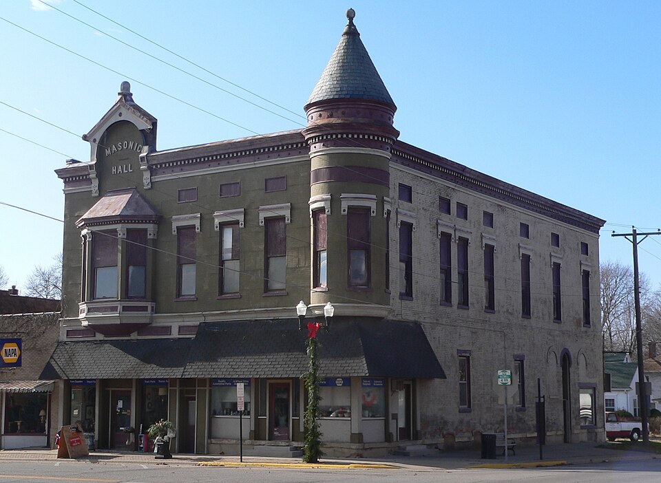
Photograph of Delavan Commercial Historic District
Photograph by Ammodramus, CC0 1.0. Via Wikimedia Commons.

Delavan Commercial Historic District

Listed on the National Register of Historic Places in 1991.

From the record

“The Delavan Commercial Historic District is a historic district in downtown Delavan, Illinois. The district includes 26 buildings along two blocks of Locust Street, 20 of which are contributing buildings.”

Wikipedia article Delavan Commercial Historic District, CC BY-SA 4.0.

One of 16 National Register listings published here for Tazewell County · listed in 1991 · category: District.

Sources: the Wikipedia article · the case file at the National Archives · the National Register database, National Park Service
The listing

The ground it stands on

8,602 words

The chapter on Delavan Township in History of Tazewell County, Illinois ; Together with Sketches of Its Cities, Villages and Townships, Educational, Religious, Civil, Military, and Political History; Portraits of Prominent Persons and Biographies of Representative Citizens. History of Illinois ... Digest of State Laws, published 1879 names Delavan. This is what it says, exactly as the scans read.

The history of Delavan is peculiar to itself. It began with the Western trip of Deacon Jonas E.. Gale, which was made in 1836. Having met Mr. Wright, of Dillon, in the East, the latter invited him, in case he came West, to be sure and make him a visit. Deacon Gale, after making arrangements to settle at Alton, started for home, with the intention of visiting Tazewell county on the way. He was struck with the beautiful prairie land, which then abounded in all kinds of game, and he conceived the idea of having a colony, from Providence, R. I., settle on these lands. At Tremont he fell in with Mr. Edward C. Delavan, of Albany, N. Y., who took great interest in the proposed colony. The result was, that an organization was formed, with a capital of over $20,000, and 20,000 or 22,000 acres of land were entered. Over fifty heads of families agreed to come West and settle upon these lands, or to send a substitute to do so. Accordingly the land was laid off in 160-acre farms. A town lot of 300 square feet went with each farm, as it was thought the people would want to live in town in winter. The farms were bid off at auction, at Providence, so much being paid as choice money, independently of the regular price of the land ; the amount, in some cases, ran up to $1,000. Henry R. Green, Deacon gentleman named was the financial agent. Two rules of the association were, that the place should be called Delavan, and that it should be a temperance town. In 1837, the company sent out carpenters and material to erect the Delavan House, which was to be divided into compartments suitable for family house-keeping, for the accommodation of the settlers, till they should be able to build upon their own places. Part of the material for this building was shipped from Providence, via New Orleans and Pekin, part from Pittsburgh, Pa., and part came from the Mackinaw. The material for a few dwellings was brought from the East. W. W. Grossman, with his family, accompanied the carpenters, and his wife saw no white woman for three months. She lived until the winter of 1874, and was therefore a witness of the entire growth of the community. Mr. Grossman still lives, and enjoys pretty fair health in his old age. Gomparatively few of those who enrolled themselves as actual settlers came West, and the growth cf the colony was not as vigorous as had been expected. The Deacon left Alton about 18 months after the first settlement, and has lived in Delavan ever since. Himself and Mr. Grossman are the only surviving members of the original colony, James Phillips, another member, was closely identified with the place, died not long ago. In 1840, Ira B. Hall came to Delavan and opened the Delavan House as a hotel, though some slight accommodations had been offered there previous to this. The stage line from Ghicago via Peoria to Springfield, passed about one-half mile west of the village, and about four months after Mr. Hall opened the hotel, Delavan was made a stage stand. The telegraph line was put up in 1850, and Delavan became an important point. But a little later, before the G. & A. railroad was built, the poles were taken down, the stage withdrawn, and the place became shut out from the world. Atlanta was the nearest railroad point, and thither the people carried their produce, and made many of their purchases. This continued till 1868, when the branch of the G. & A. road was completed, and from this time the place began to grow with great rapidity. The first store was kept by a man named West, who was also the first postmaster, and who was succeeded by Ira B. Hall. It seems that James Phillips bought out West and kept a small stock of goods for a time. Geo. Straut and Putnam came along one day with a one horse peddlers' wagon, and they traded the horse and wagon with Phillips for the goods. Putnam kept the store, and Mr. Straut, who was a blacksmith by trade, went back to St. Louis to work. After a time he returned to Delavan, worked a while at blacksmithing, increased his stock of goods, and was soon doing a prosperous business. Mr. Straut became interested in Mason City and amassed considerable property, and now has an influential voice in the affairs of the C. & A. railroad.

Passage source: History of Tazewell County, Illinois ; Together with Sketches of Its Cities, Villages and Townships, Educational, Religious, Civil, Military, and Political History; Portraits of Prominent Persons and Biographies of Representative Citizens. History of Illinois ... Digest of State Laws, published 1879.

In 1858 the village of Delavan was incorporated, but opposition to the movement was so strong that the Trustees elected did not qualify, and the incorporation seems to have fallen through. It was organized Oct. 2, 1865, when it was voted to establish the corporaporation to include the old town proper, and its platted additions. The following were the first officials : Trustees - E. O. Jones, president ; L. P. Flynt, clerk ; J. C. Appleton, Stephen C. Hobart, Wm. B. Orrell, and P. Clark ; city marshal, J. H. Upham ; collector, Wm. Vaughn ; treasurer, D. L. Whittemore. The village was incorporated under the new State law in July, of 1872, with the following Trustees : Theo. Van Hague, president ; Wm. H. Phillips, clerk ; P. D. Stockwell, Henry Kingman, John Carr, Andrew Stubbs and John Warne. In 1874 the subject of license or no license came up, and the board stood four to two against the granting of license ; in '75, '76 and '77 licenses were granted ; but in '78 the board was again four to two against, and in '79 unanimous against authorizing the sale of liquor.

Passage source: History of Tazewell County, Illinois ; Together with Sketches of Its Cities, Villages and Townships, Educational, Religious, Civil, Military, and Political History; Portraits of Prominent Persons and Biographies of Representative Citizens. History of Illinois ... Digest of State Laws, published 1879.

Machine-read from a century-old scan, so expect the errors a machine makes: misspelled names, dropped words, stray characters.

Read the whole chapter on Delavan Township - 8,602 words on its settlement, mills, schools and churches.

Fires near this property

1 since 2018

Regional context, not property-specific evidence. The federal wildfire occurrence database lists 1 fire within 5 miles of Delavan Commercial Historic District in 2018, burning about 2 acres in total. None started naturally. None was recorded as arson. Distance is straight-line from the map coordinates, so a fire counted here may appear on a neighbouring settlement's page as well.

Reported cause Fires
Power generation/transmission/distribution1

The most recent of them, most recent first, with the day each was reported and the service that recorded it.

DateCause SizeReported by Name on the report
5 September 2018Power generation/transmission/distribution2.0 acresIllinois Division of Forestry Resources087-18

Every fire recorded in Tazewell County

Mines and quarries near this property

1 within 5 miles

Regional context, not property-specific evidence. The federal mineral resources record lists 1 working within 5 miles of Delavan Commercial Historic District: 1 past producer. None of them still produces. What was taken out: Sand and Gravel, Construction. Distance is straight-line from the map coordinates, so a quarry counted here may appear on a neighbouring settlement's page as well.

Where SiteCommodity StatusRecorded
Woods Sand PitSand and Gravel, ConstructionPast Producer

Every working recorded in Tazewell County

Storms near this property

38 since 1994

Regional context, not property-specific evidence. The National Weather Service names Delavan, the town this property stands in, in 38 storm reports between 1994 and 2026: 21 thunderstorm wind, 14 hail, 3 tornado. The reports record 7 injuries. Each account below is quoted exactly as the forecast office filed it, from the NOAA Storm Events Database, and each date opens the federal record of that event.

WhenEvent Place namedHarm What the report says
February 1999Thunderstorm WindDelavan6 hurt, $40,000Widespread damage occurred in Tazewell County. As the severe thunderstorm moved northeast across the county, it took the roof off of a corn crib and flipped over an irrigation rig 3 miles southwest of Delavan then blew the roof off of a house in Delavan. In South Pekin, around a dozen power poles were blown down and six miles south of Tremont the tops of numerous trees were torn off and a swing set was blown over. Two miles northeast of Morton, 6 semis were blown over on I-74 causing 6 minor injuries. Also, in Tremont a semi was blown over on Route 9 near the interchange with I-155. No injuries occurred with this incident. Countywide numerous trees were blown over and several sheds, barns, and outbuildings were either damaged or destroyed. Damage to two of the semis that were blown over is estimated around $40,000.
July 2015Tornado (EF2)Delavan1 hurt, $1,200,000A tornado touched down 0.6 miles south of Delavan at 11:39 PM CDT. The tornado then moved east-northeast across the south side of Delavan, damaging 51 homes. 15 of the homes sustained severe damage, including either the roofs being completely torn off or the majority of the roof deck being lifted off. Numerous garages, outbuildings, and trees were damaged. The tornado also crossed through the Prairie Rest Cemetery, damaging grave markers and several trees before dissipating in a cornfield 2.2 miles east-northeast of Delavan at 11:46 PM CDT.
March 2017Tornado (EF2)Delavan$120,000A tornado touched down in an open field 1.4 miles north-northeast of Delavan at 12:09 CST. The tornado quickly tracked northeastward and widened to 200 yards, causing EF-2 damage to one outbuilding and EF-1 damage to several other outbuildings and trees. It continued northeastward before dissipating 4.1 miles northeast of Delavan at 12:13 AM CST.
May 2011Thunderstorm WindDelavan$60,000Part of the roof was blown off the high school. Power was knocked out to the south side of Delavan.
May 2011Thunderstorm WindDelavan$35,000Windows were broken at a house and a metal shed was blown onto a road about 1 mile east of Delavan.
September 2019Thunderstorm WindDelavan$20,000Numerous trees and tree branches were blown down in Delavan.
June 2018Thunderstorm WindDelavan$6,000Several pine trees were snapped.
March 2023Thunderstorm WindDelavan-Power pole and lines were blown down.
May 2019Thunderstorm WindDelavan-A 12-inch diameter tree was blown over.
May 2019Thunderstorm WindDelavan-An 18-inch diameter tree was blown over.
May 2019Thunderstorm WindDelavan-A utility pole was blown down in Delavan.
July 2008Thunderstorm WindDelavan-A portion of a large tree fell across a road.
May 2004Thunderstorm WindDelavan-Thunderstorm winds blew down several telephone poles as well as large tree limbs.
April 2003Thunderstorm WindDelavan-Numerous large tree limbs were blown down.
May 2002Thunderstorm WindDelavan-Several power lines were blown down around town.
June 1999Tornado (F1)Delavan-A tornado touched down on the northwest side of Delavan. It uprooted several large trees. The only structural damage in this area was due to tree branches. As it travelled to the east southeast, it blew a small outdoor amphitheater into a nearby creek. As the tornado moved into the northeast side of town, it knocked down numerous trees. One tree fell onto an unoccupied truck, another one fell onto the roof of a house, and still another one fell onto a mobile home. Several other homes sustained minor damage to their roofs and siding on a few homes was ripped off. As the tornado moved east southeast out of town it weakened somewhat. It uprooted several more trees, knocked down more branches, and destroyed a small shed 2 miles east southeast of Delavan before lifting and dissipating. No injuries were reported.
June 1999Thunderstorm WindDelavan-A semi was blown over on I-155 east of Delavan. The driver was uninjured. Several trees were blown down nearby.
August 1999Thunderstorm WindDelavan-Several large tree limbs blown down.
June 1995Thunderstorm WindDelavan-Severe thunderstorms downed 6- to 12-inch-diameter tree limbs throughout the county.
June 1994HailDelavan-A television crew taped a brief tornado touchdown at Spring Street in East Peoria. Near Washington, a two mile wide path of crop damage was caused by thunderstorm winds and several houses had siding damaged. At Creve Coeur, three inch diameter limbs were blown down and a vent stack was blown off the roof of Wesleyan Church. At Pekin, large tree limbs were blown down and trees were blown down along Highway 98. Marble- to golf ball-size hail covered the ground at Tremont. Crops were damaged by high winds. Large trees were blown down at Townline and Schrader Roads. Winds also damaged siding on several houses.
March 2026HailDelavan-no account filed
August 2023Thunderstorm WindDelavan-no account filed
June 2013HailDelavan-no account filed
April 2011HailDelavan-no account filed
June 2008HailDelavan-no account filed
March 2006HailDelavan-no account filed
March 2005HailDelavan-no account filed
June 2005Thunderstorm WindDelavan-no account filed
April 2004Thunderstorm WindDelavan-no account filed
May 2004HailDelavan-no account filed
August 2001HailDelavan-no account filed
October 2001Thunderstorm WindDelavan-no account filed
May 2000HailDelavan-no account filed
June 1998HailDelavan-no account filed
June 1996Thunderstorm WindDelavan-no account filed
April 1996HailDelavan-no account filed
June 1995HailDelavan-no account filed

Every storm recorded in Tazewell County

Map coverage status

No historic map-sheet match is published for this property yet. That does not mean no map exists. This record needs a coordinate-quality review before it can be joined to a sheet boundary. Browse the county's mapped places while that work is pending.

Listed places nearby

3 within 8 miles

Other National Register properties close enough to walk or drive between, ordered by distance from this one. Both positions come from the same geocoding pass that matched these properties to their map sheets.

Photograph PropertyDistance Listed
Ayer Public Library0.1 miles1998
Third St. Bridge0.2 miles1999
Waltmire Bridge5.9 miles1999

Sources for this property

National Archives recordThe nomination case file for reference 91001687 in Record Group 79.
Wikipedia articleCommunity-written account of this property, licensed CC BY-SA.
Tazewell CountyAll 16 listed properties in this county.

Provenance

  • Listing record. National Park Service National Register of Historic Places, listed-properties dataset, current to 2026-05-22.
  • Map join. Address geocoded through the United States Census geocoder, then tested against the published boundary of every sheet in the USGS Historical Topographic Map Collection.
  • How this page is made. Listing fields come from federal records; map-sheet coverage is a labelled coordinate-to-boundary calculation, not a source-field claim.
  • Wildfire. Short, Karen C. 2022. Spatial wildfire occurrence data for the United States, 1992-2020 [FPA_FOD_20221014]. 6th Edition. Fort Collins, CO: Forest Service Research Data Archive. https://doi.org/10.2737/RDS-2013-0009.6 Collected with United States Government funding and usable without additional permissions or fees.
  • Mines and quarries. USGS Mineral Resources Data System (MRDS) https://mrdata.usgs.gov/mrds/ A work of the United States government, no copyright under 17 U.S.C. 105.
  • Storms. NOAA National Centers for Environmental Information, Storm Events Database https://www.ncei.noaa.gov/stormevents/ A work of the United States government, no copyright under 17 U.S.C. 105. Narratives are quoted verbatim from the National Weather Service report and are not edited or summarised.