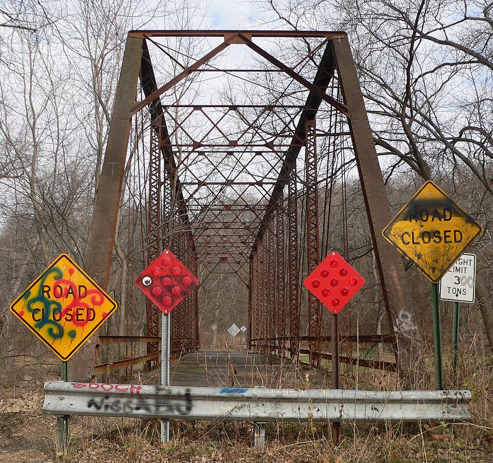
Listed on the National Register of Historic Places in 1999.
From the record
“The Waltmire Bridge is a historic bridge which carried Locust Road across the Mackinaw River 4.9 miles (7.9 km) south of Tremont, Illinois. The bridge was built in 1910 by contractor Edward Cooney at the site of Waltmire's Ford, a shallow point in the river that could only be easily crossed when water levels were low.”
Wikipedia article Waltmire Bridge, CC BY-SA 4.0.
One of 16 National Register listings published here for Tazewell County · listed in 1999 · category: Structure.
National Register reference number.99000112- the number the National Park Service assigned this property when it was listed, and the key its nomination file is catalogued under at the National Archives.
What happened here
An account from the chapter on Dillon township. The inset identifies its exact
source book and publication year.
Matthias Mount came in 1833, Feb. 20. He served in the Black Hawk war, as Second Lieutenant in Co. C, 1st regt. He was at the battles of Wisconsin and Bad Axe, and attended the treaty at Rock Island, and says our portrait of Black Hawk is an excellent one. He had a horse shot from under him.
Regional context, not property-specific
evidence. The federal mineral resources record lists
11 workings within 5 miles of Waltmire Bridge: 6 past producers, 5 producers.
5 still produce. What was taken out: Sand and Gravel, Construction. Distance is straight-line from the
map coordinates, so a quarry counted here may appear on a neighbouring
settlement's page as well.
Regional context, not property-specific
evidence. The National Weather Service names
Tremont, the town this property stands in, in 25 storm reports between 1994 and 2026: 12 thunderstorm wind, 11 hail, 2 tornado.
The reports record 25 injuries. Each account below is quoted exactly as the forecast office
filed it, from the NOAA Storm Events Database, and each date
opens the federal record of that event.
A tornado touched down along the Illinois River (3 NE of Goofy Ridge) and traveled to the northeast for 25 miles before lifting and dissipating in Tremont (Tazwell County). The tornado damaged or destroyed over 36 homes and mobile homes in Mason County and injured 23 people. Numerous trees were blown down, especially in the Sand Ridge State Forest, as well as, numerous power poles. In Tazwell County, 25 homes were either damaged or destroyed (seven homes were destroyed in a subdivision 1 S of South Pekin were two people suffered minor injuries). Numerous silos and machine sheds were destroyed. Damage was estimated around $4 million.
A tornado touched down just southwest of the intersection of Red Shale Hill Road and Locust Road about 2 miles south of Tremont at 8:49 PM CDT. It tracked northeastward through mainly rural areas, damaging numerous trees and a couple power poles. The most intense part of the tornado occurred when it uprooted a 3-foot diameter tree, snapped a power pole, and peeled the top off a grain bin. It continued northeastward, then dissipated in a field northeast of the intersection of Dee Mack Road and Cooper Road about 2 miles north of Deer Creek at 9:05 PM CDT.
A television crew taped a brief tornado touchdown at Spring Street in East Peoria. Near Washington, a two mile wide path of crop damage was caused by thunderstorm winds and several houses had siding damaged. At Creve Coeur, three inch diameter limbs were blown down and a vent stack was blown off the roof of Wesleyan Church. At Pekin, large tree limbs were blown down and trees were blown down along Highway 98. Marble- to golf ball-size hail covered the ground at Tremont. Crops were damaged by high winds. Large trees were blown down at Townline and Schrader Roads. Winds also damaged siding on several houses.
No historic map-sheet match is published
for this property yet. That does not mean no map exists. This record needs
a coordinate-quality review before it can be joined to a sheet boundary.
Browse the county's mapped places while that work is
pending.
Listed places nearby
3 within 8 miles
Other National Register properties close
enough to walk or drive between, ordered by distance from this one. Both
positions come from the same geocoding pass that matched these properties
to their map sheets.
Listing record. National Park Service National Register of Historic Places, listed-properties dataset, current to 2026-05-22.
Map join. Address geocoded through the United States Census geocoder, then tested against the published boundary of every sheet in the USGS Historical Topographic Map Collection.
How this page is made. Listing fields come from federal records; map-sheet coverage is a labelled coordinate-to-boundary calculation, not a source-field claim.
Mines and quarries. USGS Mineral Resources Data System (MRDS) https://mrdata.usgs.gov/mrds/ A work of the United States government, no copyright under 17 U.S.C. 105.
Storms. NOAA National Centers for Environmental Information, Storm Events Database https://www.ncei.noaa.gov/stormevents/ A work of the United States government, no copyright under 17 U.S.C. 105. Narratives are quoted verbatim from the National Weather Service report and are not edited or summarised.
 Block