BlockBefore
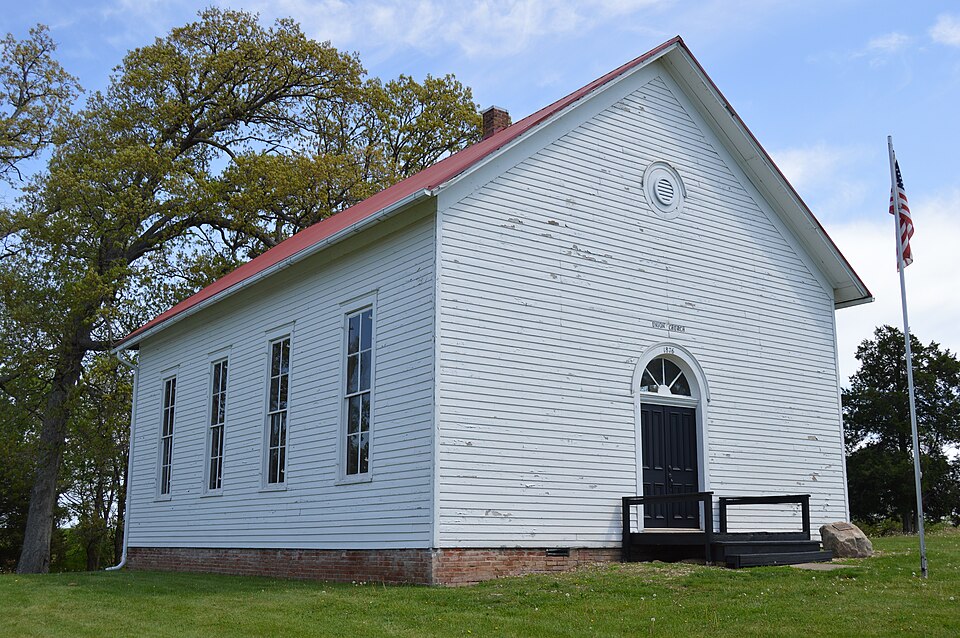
Photograph of Union Church
Photograph by Nyttend, Public domain. Via Wikimedia Commons.

Union Church

Listed on the National Register of Historic Places in 1999.

From the record

“Union Church is a historic non-denominational church located 2.5 miles (4.0 km) southeast of Oreana in Macon County, Illinois. The white frame church was built in 1876; its design incorporates elements of the Greek Revival and Italianate styles.”

Wikipedia article Union Church (Oreana, Illinois), CC BY-SA 4.0.

One of 11 National Register listings published here for Macon County · listed in 1999 · category: Building.

Sources: the Wikipedia article · the case file at the National Archives · the National Register database, National Park Service · the Wikipedia article


The listing

  • What is counted as historic. The nomination lists 1 building, 1 site as contributing to the listing.
  • Address. 2.5 mi. SE of Oreana, on Kirby Rd., Oreana, 62554
  • When was it listed? September 1999
  • Category. building
  • Township. Whitmore township
  • Architectural style. Greek Revival architecture, Renaissance Revival architecture
  • National Register reference number. 99000588 - the number the National Park Service assigned this property when it was listed, and the key its nomination file is catalogued under at the National Archives.

The ground it stands on

1,784 words

The chapter on Whitmore Township in History of Macon County, Illinois : with Illustrations Descriptive of Its Scenery, and Biographical Sketches of Some of Its Prominent Men and Pioneers, published 1880 names Oreana. This is what it says, exactly as the scans read.

Mr. Henry Rhodes, a very pleasant and intelligent old gentleman, who is still living a short distance west of Oreana, has the honor of being the first justice of the peace. The first blacksmith shop was opened and occupied by George Eicholtz, who was ably qualified to attend to the wants of the settlers in that line of business. We also find S. T. Miller on section 21, Town 17, Range 3 East, with a blacksmith shop able to do all kinds of work in that line.

Passage source: History of Macon County, Illinois : with Illustrations Descriptive of Its Scenery, and Biographical Sketches of Some of Its Prominent Men and Pioneers, published 1880.

Oreana is a village located on section 9, Tp. 17, R. 3 East. It is situated on the beautiful prairie, and is the only village or town in this township. It lies on each side of the Champaign, Havana and Western Railroad, which traverses this township. The first house erected in Oreana was a dwelling, built by Henry Morrisson, in the year 18 - . In the same year S. G. Coale opened the first store of general merchandize, which business he followed for a number of years. Another important event in the history of Oreana was the establishment of a post-office, with S. G. Crocker as post-master. In 1874 the Baptist Congregation had so increased in numbers as to be able to build a church, thereby being entitled to the honor of erecting the first church edifice in the village. The Rev. Mr. Ingmeyer was the first minister to locate in Oreana. Dr. Cheneworth was the first physician to practice medicine in this village. Oreana is a live business point, and commands the trade of quite a large territory. It is about seven miles north-east from Decatur. The following is a list of the present business houses in this place: General Stores - Frank M. Pratt; Ruddock & Kirby. Grain

Passage source: History of Macon County, Illinois : with Illustrations Descriptive of Its Scenery, and Biographical Sketches of Some of Its Prominent Men and Pioneers, published 1880.

Machine-read from a century-old scan, so expect the errors a machine makes: misspelled names, dropped words, stray characters.

Read the whole chapter on Whitmore Township - 1,784 words on its settlement, mills, schools and churches.

Mines and quarries near this property

1 within 5 miles

Regional context, not property-specific evidence. The federal mineral resources record lists 1 working within 5 miles of Union Church: 1 past producer. None of them still produces. What was taken out: Sand and Gravel, Construction. Distance is straight-line from the map coordinates, so a quarry counted here may appear on a neighbouring settlement's page as well.

Where SiteCommodity StatusRecorded
Chastain Construction Co. PitSand and Gravel, ConstructionPast Producer

Every working recorded in Macon County

Storms near this property

15 since 1997

Regional context, not property-specific evidence. The National Weather Service names Oreana, the town this property stands in, in 15 storm reports between 1997 and 2024: 7 thunderstorm wind, 5 hail, 3 tornado. No death or injury is recorded in these reports. Each account below is quoted exactly as the forecast office filed it, from the NOAA Storm Events Database, and each date opens the federal record of that event.

WhenEvent Place namedHarm What the report says
August 2015Thunderstorm WindOreana$1,000A tree was blown down in Oreana.
June 2023Thunderstorm WindOreana-Several large tree branches were blown down along Christmas Tree Road.
August 2022Thunderstorm WindOreana-A large tree was broken on East Mound Road near Highway 48.
August 2022Thunderstorm WindOreana-Several large tree branches and power lines were blown down.
May 2019Thunderstorm WindOreana-A vehicle was hit by a falling tree on Kirby Road. No injuries were reported.
May 2019Thunderstorm WindOreana-A 30 by 50-foot Quonest hut was destroyed.
May 2019Thunderstorm WindOreana-A large 16-inch diameter tree was split in half on Rayjon Dr. Power poles and numerous tree limbs were blown down across town.
July 2006Tornado (F0)Oreana-A tornado briefly touched down in a field causing crop damage.
April 2000Tornado (F1)Oreana-The tornado touched down 1.8 miles northeast of Oreana, just east of Route 48. It moved to the northeast along Route 48, entering Argenta. The most severe damage was in two areas. The first was about 2 miles northeast of Oreana where the roof of a two story house was lifted off. The second was on the southwest side of Argenta, where part of the roof of a two story brick building was lifted off and placed on top of a lower building roof. Also, numerous trees, power poles, and power lines were blown down. A garage was destroyed in Argenta. No injuries were reported.
April 1997Tornado (F0)Oreana-A tornado briefly touched down in Oreana, destroying a mobile home and a barn. No injuries were reported and no damage estimate was available.
March 2024HailOreana-no account filed
April 2006HailOreana-no account filed
May 2004HailOreana-no account filed
May 2003HailOreana-no account filed
May 1998HailOreana-no account filed

Every storm recorded in Macon County

Map coverage status

No historic map-sheet match is published for this property yet. That does not mean no map exists. This record needs a coordinate-quality review before it can be joined to a sheet boundary. Browse the county's mapped places while that work is pending.

Listed places nearby

4 within 8 miles

Other National Register properties close enough to walk or drive between, ordered by distance from this one. Both positions come from the same geocoding pass that matched these properties to their map sheets.

Photograph PropertyDistance Listed
Wabash Railroad Station and Railway Express Agency7.3 miles1994
Roosevelt Junior High School7.6 miles2002
Transfer House7.7 miles2002
Decatur Downtown Historic District7.8 miles1985

Sources for this property

National Archives recordThe nomination case file for reference 99000588 in Record Group 79.
Wikipedia articleCommunity-written account of this property, licensed CC BY-SA.
Macon CountyAll 11 listed properties in this county.

Provenance

  • Listing record. National Park Service National Register of Historic Places, listed-properties dataset, current to 2026-05-22.
  • Map join. Address geocoded through the United States Census geocoder, then tested against the published boundary of every sheet in the USGS Historical Topographic Map Collection.
  • How this page is made. Listing fields come from federal records; map-sheet coverage is a labelled coordinate-to-boundary calculation, not a source-field claim.
  • Mines and quarries. USGS Mineral Resources Data System (MRDS) https://mrdata.usgs.gov/mrds/ A work of the United States government, no copyright under 17 U.S.C. 105.
  • Storms. NOAA National Centers for Environmental Information, Storm Events Database https://www.ncei.noaa.gov/stormevents/ A work of the United States government, no copyright under 17 U.S.C. 105. Narratives are quoted verbatim from the National Weather Service report and are not edited or summarised.