 Block
From the record
17 National Register listings published here.
Sources: the National Register database, National Park Service
79 topographic sheets cover 39 settlements here, and 17 properties are on the National Register of Historic Places.
17 National Register listings published here.
Sources: the National Register database, National Park Service
Every property in this county listed on the National Register of Historic Places, with the year it was listed and the federal nomination document.
| Photograph | Property | Type | Listed | Reference |
|---|---|---|---|---|
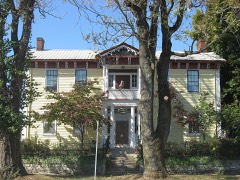 | Allison-Robinson House | building | 1993 | 93000468 |
 | David Enoch Beem House | building | 1989 | 89000771 |
 | CCC Recreation Building-Nature Museum | building | 1993 | 93000176 |
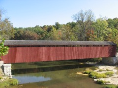 | Cataract Covered Bridge | structure | 2005 | 05000339 |
 | Gosport Historic District | district | 2013 | 13000425 |
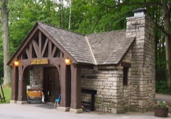 | McCormick's Creek State Park Entrance and Gatehouse | building | 1993 | 93000175 |
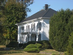 | Moffett-Ralston House | building | 1975 | 75000010 |
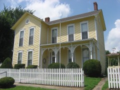 | Dr. H. G. Osgood House | building | 1999 | 99001075 |
 | Owen County Courthouse | building | 1994 | 94001351 |
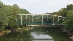 | Secrest Ferry Bridge | structure | 1996 | 96000603 |
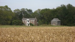 | Secrest-Wampler House | building | 2002 | 02000199 |
| Spencer Courthouse Square Historic District | district | 2020 | 100005510 | |
| Spencer Presbyterian Church and Manse | building | 2020 | 100005511 | |
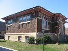 | Spencer Public Library | building | 2007 | 07000980 |
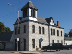 | Spencer Town Hall and Fire Station | building | 1982 | 82000027 |
 | Stone Arch Bridge over McCormick's Creek | structure | 1993 | 93000177 |
| Vandalia Methodist Episcopal Church and Vandalia School | building | 2019 | 100004045 |
Owen County has 1 covered bridge on the National Register. Each is a listed structure with a federal nomination on file.
| Cataract Covered Bridge | Listed 2005 |
The NOAA Storm Events Database holds 262 reports for this county, causing 3 deaths, 9 injuries and about $78,163,800 in recorded property damage. Each settlement page carries the reports that name it.
| Kind of event | Reports |
|---|---|
| Thunderstorm Wind | 127 |
| Hail | 56 |
| Flash Flood | 28 |
| Flood | 25 |
| Tornado | 15 |
| Heavy Rain | 8 |
| Funnel Cloud | 2 |
| Lightning | 1 |
The most serious of them, by death, then injury, then recorded damage. The accounts are quoted exactly as the forecast office filed them.
| When | Event | Place named | Harm | What the report says |
|---|---|---|---|---|
| March 2023 | Tornado (EF3) | Spencer | 2 killed, 2 hurt, $1,566,000 | The rotating supercell thunderstorm tracked over the town of Spencer before spawning a second, violent EF3 tornado, that first tracked through extreme northeastern Owen County. The tornado touched down in the McCormick's Creek State Park Campground Loop B, where EF2-intensity winds produced extensive tree damage. About 400 yards east the tornado impacted many campers at Campground Loop A, where two campers were killed and two others were injured. About 1.25 miles to the east-northeast further EF2-intensity damage occurred at Concord Road where large sections of a home's roof were removed while cars where crushed, rolled and thrown; here along the circulation's southern side the roof was blown off of a mobile home as it slid off its block piers, yet remained upright, consistent with high-end EF1 intensity winds.||The tornado intensified to EF3 strength as it neared the Owen-Monroe County line, with two barns 300-500 feet west of North County Line Road completely gone as their debris was lofted a quarter mile into Monroe County; a new farm combine weighing about 12 tons and other tractor implements were lofted and thrown 50 yards; debarking of trees also began near County Line Road, with only stubs of largest branches remaining, from the tornado's strongest winds of 153 mph. Less intense damage was again observed south of the path's center near the county line where unanchored outbuildings were destroyed by collapsed walls; and single-family homes experienced minor loss of roofing and broken glass, consistent with EF1-intense winds. The tornado maintained EF3 intensity while crossing into Monroe County. |
| December 2013 | Flash Flood | Adel | 1 killed, $5,000 | An Owen County woman was killed Christmas Eve when her car hit flooded waters on her way to a Christmas family gathering. According to a release, emergency crews responded to the area around 8:00 p.m. Tuesday for a call that a car landed in flooded water. When they got to the vehicle, they say there wasn't anyone inside. After a brief search, including a door-to-door search, they found the driver, 86, partially submerged in the water a short distance from the car. She was pronounced dead at the scene. |
| July 2003 | Thunderstorm Wind | Spencer | 5 hurt | Over 100 trees were toppled at McCormick Creek State Park injuring 5. |
| April 1975 | Tornado (F2) | not stated | 1 hurt, $250,000 | no account filed |
| September 2000 | Thunderstorm Wind | Southport | 1 hurt, $20,000 | no account filed |
| June 2008 | Flood | Spencer | $50,000,000 | Flooding occurred along the White River in Owen County, including near Spencer, due to heavy rain. |
| June 2021 | Flash Flood | Freedom | $20,000,000 | Numerous local and county roads closed due to high water. A couple were rescued by boat from the roof of their vehicle on State Road 43. Additional water rescues were done across Owen and Monroe counties. 1500 Fish Creek road was completely flooded with water rapidly flowing across the road. White Road along Raccoon Creek was destroyed by flood waters. Across the county roads have suffered severe damage, 23 culverts have been washed out and 2 bridges have significant damage. In all, over 30 Owen County roads are closed. A local emergency disaster declaration was created later in the day. |
| June 1998 | Flash Flood | Central Portion | $4,000,000 | Six to 12 inch rains in about four hours between Freedom and Spencer resulted in extreme flash flooding. Flood waters washed out 9 bridges, 8 culverts, one road, and several houses. |
| May 2004 | Tornado (F1) | Freedom | $300,000 | An F1 tornado skipped along for almost 8 and a half miles from near Freedom to Spencer. A few homes received significant damage about midway along the path of the tornado. |
| June 2024 | Thunderstorm Wind | Spencer | $250,000 | Numerous trees downed by thunderstorm wind gusts in Spencer and across the southern portions of the county. |
| June 1976 | Tornado (F2) | not stated | $250,000 | no account filed |
| June 2008 | Flash Flood | Spencer | $200,000 | Spencer had multiple flood damaged homes. State Roads 43, 46, and 67 were all closed. United States 231 was also closed. Roads and bridges were washed out. Water was over railroad tracks near Gosport. Cars and golf carts were under water. Over 60 roads were washed out. Campers were stranded. |
| June 2021 | Thunderstorm Wind | Southport | $100,000 | A house at the 1500 block of Freeman Road had structural damage from thunderstorm wind gusts when a tree fell on the house. Trees were downed all along Freeman road from the 1000 block of Freeman Road to State Road 43. There was also some tree damage on Hardscrabble Road from State Road 43 to the 2800 block of Hardscrabble Road where a pole barn had the door blown in and south wall blown out. |
| June 2019 | Tornado (EF1) | Freedom | $100,000 | The EF-1 rated tornado, with max wind speeds of 110 mph, began just southwest of downtown Freedom before moving into the town shearing numerous trees around town. The tornado continued to the northeast leaving a very clear path of sheared and uprooted trees in a path about 200 yards wide. The storm crossed the White River several times over its lifetime and followed the river line to south of Spencer. This is where a large building had its roof uplifted and walls collapsed. The building was part of a business that was set to open for the first time on Monday. The damage ended shortly after and the storm recycled into the next tornado. |
| July 2000 | Lightning | Quincy | $100,000 | A house was burned to the ground after getting struck by lightning. |
| March 2006 | Flood | Spencer | $100,000 | no account filed |
| May 2025 | Hail | Adel | $50,000 | Reports of vehicle dents with broken windows to houses and vehicles. |
| May 2022 | Thunderstorm Wind | Arney | $50,000 | Grain bin blown on top of house by thunderstorm wind gusts. Report relayed from twitter by broadcast media. |
| July 2010 | Thunderstorm Wind | Coal City | $50,000 | A roof was reportedly blown off a house due to thunderstorm wind gusts and a barn was blown into a house. |
| April 1994 | Tornado (F1) | Whitehall | $50,000 | Small tornado briefly touched down at Whitehall destroying one mobile home, damaging one church roof, and downing several trees. |
| May 2002 | Flash Flood | Countywide | $50,000 | no account filed |
| August 2000 | Thunderstorm Wind | Cataract | $50,000 | no account filed |
| April 2007 | Thunderstorm Wind | Jordan | $30,000 | Law enforcement reported a roof off a mobile home and a barn. |
| April 2025 | Flash Flood | Southport | $25,000 | Water from Lake Hollybrook is flooding onto road. Numerous roads closed. Total rainfall ranged from 3.4 to 4.1 inches. |
| July 2025 | Flash Flood | Freeman | $25,000 | Flash flooding in the area of the intersection of Bakers School Road and Franklin Road from area creeks and streams. |
| May 2011 | Thunderstorm Wind | Coal City | $25,000 | A barn was destroyed and blown across the road. Power lines and trees were reported down as well. |
| May 2002 | Flash Flood | New Hope | $25,000 | no account filed |
| May 1989 | Tornado (F1) | not stated | $25,000 | no account filed |
| July 2023 | Thunderstorm Wind | Vandalia | $20,000 | Thunderstorm winds downed a tree on Fish Creek Road. Power lines were also downed on Country Club Road. |
| May 2022 | Thunderstorm Wind | Gosport | $20,000 | Thunderstorm wind downed large trees into power lines. Reported via twitter with video. |
| June 2008 | Tornado (EF0) | Gosport | $20,000 | This tornado formed near Marley Road and Old Boundary Line Road in Owen County. The tornado tracked 3.02 miles to the northeast while in Owen County and passed through Gosport. The tornado moved into Morgan County while moving through an open field. The field is located 3,500 feet east of Drunkards Pike, 1,000 feet north of South Lingle Road, and 1,300 feet south of State Road 67. The tornado continued to the northeast for 1.05 miles in Morgan County before lifting 1,000 feet east of South Vickery Road between State Road 67 and South Lingle Road. This made the total path of the tornado 4.07 miles. The tornado was rated EF-0 while in both counties with wind speeds around 80 miles per hour. The tornado lasted from 1912 to 1916 EST while in Owen County and from 1916 to 1917 EST while in Morgan County. Overall, the tornado was on the ground from 1912 to 1917. The width of the tornado at its peak in both counties was approximately 175 yards. While in Owen County minor damage was sustained to trees, a gas station, a fire station, and residences. While in Morgan County trees, barns, and residences were affected by the tornado. Two young girls were caught outside on property that received the most extensive damage in Morgan County from this tornado. They received minor cuts, scrapes, and bruises from flying debris. |
| March 2023 | Thunderstorm Wind | Gosport | $17,000 | Supercell thunderstorm straight line winds gusted to 58-83 mph for 8 minutes from 2202 to 2210 EST, downing at least 3 trees amid dime-sized hail and horizontal rain. Also, a nearby large tree was downed into a barn. |
| June 2025 | Thunderstorm Wind | Gosport | $15,000 | Trained spotter measured a 71 mph thunderstorm wind gust. Trees and power lines reported down from thunderstorm wind gusts as well. |
| May 2013 | Thunderstorm Wind | Freedom | $15,000 | Trees were reported down, along with some structural roof damage, due to damaging thunderstorm wind gusts. Power outages were also noted, along with dime sized hail. |
| July 2009 | Thunderstorm Wind | Spencer | $15,000 | Trees were reported down across much of the county due to thunderstorm wind gusts. |
| February 2008 | Flood | Southport | $15,000 | Flooding occurred along the White River in Owen County, including near Spencer, due to heavy rain and snow melt. |
| March 2008 | Flood | Spencer | $15,000 | Flooding occurred along the White River in Owen County, including near Spencer, due to heavy rain. Multiple roads were closed due to high water. |
| March 2008 | Flood | Spencer | $15,000 | Flooding occurred along the White River in Owen County, including near Spencer, due to heavy rain and snow melt. |
| June 2014 | Tornado (EF0) | Quincy | $12,000 | The first tornado from the thunderstorm touched down at approximately 1:15 PM EDT, 5.4 miles northwest of the town of Gosport along Truesdel Road, just east of McFarren Road, in Owen County. This tornado was rated EF-0 with winds estimated at 85 mph uprooting trees and causing minor damage to several buildings. This tornado lifted at 1:16 PM EDT after traveling one half mile. |
| June 2007 | Flood | Spencer | $11,000 | Rainfall of 2.23 inches fell in 1 hour causing streets, including West Morgan Street and Vandalia Avenue, to flood in Spencer. Flooding also caused water damage to two businesses. |
| April 2023 | Thunderstorm Wind | Gosport | $10,000 | Several large trees and power lines downed by thunderstorm wind gusts. |
| April 2018 | Flash Flood | Carp | $10,000 | Bush Road was reported to be washed out due to heavy thunderstorm rainfall. Locust Lake Drive near this same location was flooded as well. Also, portions of Highway 231 North and Atkinsonville Road were reported to be flooded. |
| July 2012 | Thunderstorm Wind | Freedom | $10,000 | Trees were reported down on Gloryville Road, one mile southwest of Freedom, due to damaging thunderstorm wind gusts. Trees were also down on Parrish Road and Harrington Road near Freedom. |
| January 2008 | Flood | Spencer | $10,000 | Flooding occurred along the White River in Owen County, including near Spencer, due to heavy rain and snow melt. |
| June 2008 | Thunderstorm Wind | Spencer | $10,000 | Several reports of damage were received in and around Spencer. A power line fell onto a moving vehicle. The driver reportedly drove on and was not injured. A tree was down near Hidden Valley Estates. A tree fell on top of a 1997 Ford Expedition on North Montgomery Street. |
| June 2008 | Flash Flood | Spencer | $10,000 | Law enforcement reporting much of the town of Spencer under water with other areas of the county also experiencing flash flooding due to heavy rainfall. |
| January 2007 | Flood | Spencer | $10,000 | The White River in Owen County flooded for much of January. Crests were as high as 8.1 feet above flood stage. |
| March 2007 | Flood | Spencer | $10,000 | The White River flooded in Owen County. Crests were nearly 4.5 feet above flood stage. |
| March 2007 | Flood | Spencer | $10,000 | The White River flooded in Owen County. Crests were over 4 feet above flood stage. |
| March 2007 | Flood | Spencer | $10,000 | The White River flooded in Owen County. Crests were nearly 7 feet above flood stage. |
| March 2006 | Flood | Spencer | $10,000 | A car was caught in water on State Road 46 at Rattlesnake Creek. |
| December 2006 | Flood | Spencer | $10,000 | The White River flooded in Owen County. The river crested at over 5 feet above flood stage. |
| July 2004 | Thunderstorm Wind | Spencer | $10,000 | no account filed |
| June 1999 | Thunderstorm Wind | Carp | $10,000 | no account filed |
| December 1998 | Thunderstorm Wind | Coal City | $10,000 | no account filed |
| July 2023 | Thunderstorm Wind | Carp | $7,000 | Thunderstorm winds downed several trees in northern Owen County. |
| September 2014 | Thunderstorm Wind | Gosport | $7,000 | Numerous trees were downed or snapped off above the ground near State Route 67 just north of Gosport due to damaging thunderstorm wind gusts. |
| October 2013 | Thunderstorm Wind | Atkinsonville | $7,000 | A roof was partially blown off a barn due to damaging thunderstorm wind gusts. A few trees were down as well. |
| January 2012 | Thunderstorm Wind | Gosport | $6,000 | A garage door was blown in due to damaging thunderstorm wind gusts. |
| July 2024 | Thunderstorm Wind | Spencer | $5,000 | Thunderstorm winds downed several trees in Spencer. |
The Survey's mineral resources record lists 6 workings inside this county. 4 still produce and 2 are closed or unrecorded. Each settlement page carries the workings within five miles of it.
| Commodity | Workings |
|---|---|
| Limestone, General | 2 |
| Stone, Crushed/Broken | 2 |
| Sand and Gravel, Construction | 1 |
| Stone | 1 |
The least common of them first, because a county's hundredth gravel pit says nothing its first ten did not.
| Where | Site | Commodity | Status | Recorded |
|---|---|---|---|---|
| Owens Co. Hwy. Dept | Stone | Producer | ||
| Spencer Dredge | Sand and Gravel, Construction | Producer | ||
| Dunn Limestone Quarry | Limestone, General | Past Producer | ||
| Spencer 520 Quarry | Stone, Crushed/Broken | Producer | ||
| Spencer Quarry | Stone, Crushed/Broken | Producer | ||
| Winders & Sons Limestone Quarry | Limestone, General | Past Producer |
Named settlements recorded in the Geographic Names Information System, each with the topographic sheets covering it. Villages, hamlets and abandoned places alike. Each is shown with the nearest named watercourse or landform and the survey quadrangle it falls on.
Morgan township · 47868 · Near Cooksey Hill · Cataract quadrangle
17 sheets, 1953 to 1986
Jackson township · 46120 · Near Ernie Pyle Island · Cataract quadrangle
17 sheets, 1953 to 1986
Clay township · 47460 · On Little Raccoon Creek · Whitehall quadrangle
24 sheets, 1908 to 1998
Washington township · 47460 · Near Taylor Hill · Spencer quadrangle
16 sheets, 1953 to 1986
Franklin township · 47460 · On Mills Creek · Freedom quadrangle
17 sheets, 1908 to 1986
Washington township · 47460 · On Elliston Creek · Spencer quadrangle
16 sheets, 1953 to 1986
Washington township · 47460 · On Elliston Creek · Spencer quadrangle
16 sheets, 1953 to 1986
Jefferson township · 47427 · On Hauser Creek · Coal City quadrangle
18 sheets, 1938 to 1986
Taylor township · 47456 · On Brush Creek · Quincy quadrangle
15 sheets, 1949 to 1986