 Block
From the record
7 National Register listings published here, 1 of them a National Historic Landmark.
Sources: the county history on the Internet Archive · the National Register database, National Park Service
88 topographic sheets cover 34 settlements here, and 7 properties are on the National Register of Historic Places.
7 National Register listings published here, 1 of them a National Historic Landmark.
Sources: the county history on the Internet Archive · the National Register database, National Park Service
Every property in this county listed on the National Register of Historic Places, with the year it was listed and the federal nomination document.
| Photograph | Property | Type | Listed | Reference |
|---|---|---|---|---|
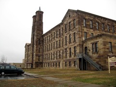 | Cannelton Cotton Mills | building | 1975 | 75000011 |
 | Cannelton Historic District | district | 1987 | 87000108 |
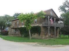 | Nester House | building | 1990 | 90001486 |
 | Old Perry County Courthouse | building | 1981 | 81000006 |
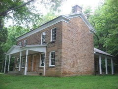 | Rickenbaugh House | building | 1984 | 84001215 |
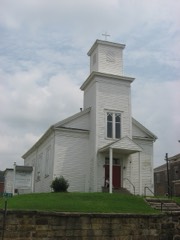 | St. Luke's Episcopal Church | building | 1983 | 83000144 |
| Tell City Carnegie Library | building | 2023 | 100008664 |
Every wildfire the federal occurrence database records inside this county: 133 of them, burning about 537 acres. 3 started naturally and 5 were recorded as arson. Each settlement page carries the fires within five miles of it.
| Reported cause | Fires |
|---|---|
| Debris and open burning | 71 |
| Missing data/not specified/undetermined | 17 |
| Equipment and vehicle use | 14 |
| Recreation and ceremony | 11 |
| Smoking | 9 |
| Arson/incendiarism | 5 |
| Natural | 3 |
| Power generation/transmission/distribution | 2 |
| Railroad operations and maintenance | 1 |
The five largest, by the area the report gives. One of them was set deliberately.
| Date | Cause | Size | Reported by | Name on the report |
|---|---|---|---|---|
| 18 March 2006 | Missing data/not specified/undetermined | 100 acres | Hoosier National Forest | LOST FIRE |
| 19 March 1995 | Recreation and ceremony | 75 acres | Hoosier National Forest | MT. SINAI |
| 10 April 2001 | Debris and open burning | 30 acres | Hoosier National Forest | KITTERMAN |
| 11 April 1993 | Recreation and ceremony | 25 acres | Hoosier National Forest | not named |
| 6 November 2007 | Missing data/not specified/undetermined | 15 acres | Hoosier National Forest | FULL RUT |
| 25 February 2004 | Debris and open burning | 15 acres | Hoosier National Forest | ASTER |
| 21 September 1999 | Arson/incendiarism | 15 acres | Hoosier National Forest | HASKINS |
| 10 March 2004 | Power generation/transmission/distribution | 14 acres | Hoosier National Forest | BEARD CEMETERY FIRE |
Every settlement page carries the fires within five miles of it - see the settlement index below.
The NOAA Storm Events Database holds 229 reports for this county, causing 5 deaths, 20 injuries and about $252,557,000 in recorded property damage. Each settlement page carries the reports that name it.
| Kind of event | Reports |
|---|---|
| Thunderstorm Wind | 105 |
| Hail | 47 |
| Flood | 36 |
| Flash Flood | 26 |
| Tornado | 15 |
The most serious of them, by death, then injury, then recorded damage. The accounts are quoted exactly as the forecast office filed them.
| When | Event | Place named | Harm | What the report says |
|---|---|---|---|---|
| May 2006 | Flash Flood | Leopold | 3 killed, $10,000 | Three were killed when a pickup truck was washed away by flood waters while attempting to cross a normally dry creek bed. One child was able to swim away from the truck and was uninjured. |
| April 1974 | Tornado (F5) | not stated | 2 killed, 6 hurt, $250,000,000 | no account filed |
| April 2002 | Tornado (F2) | Tobinsport | 12 hurt, $800,000 | Five homes were destroyed. Five mobile homes were destroyed. Four other homes had damage. The roof was torn off a church. Numerous trees were uprooted and many outbuildings were destroyed. |
| November 1970 | Tornado (F3) | not stated | 2 hurt, $25,000 | no account filed |
| April 1997 | Tornado (F1) | Bristow | $300,000 | An F1 tornado cut a 15 mile path across north central Perry county. The hardest hit areas were Apalona and Branchville. 2 mobile homes were destroyed in Apalona, and numerous roofs were lifted off houses in Branchville. Also, numerous trees were blown down with twisting evident on photographs sent by local DES. |
| December 1952 | Tornado (F3) | not stated | $250,000 | no account filed |
| June 2013 | Tornado (EF1) | Troy | $200,000 | A circulation embedded within a strong line of storms spawned an EF-1 tornado that touched down to the northwest of Tell City, in Perry County, Indiana. It moved southeast for just over 5 miles across Tell City, lifting just south of the intersection of State Highway 237 and Scotch Pine Road. Several large trees were felled along the entire tornado's path, and several homes in Tell City received damage to their roofs. Numerous outbuildings were destroyed. A carnival site at the intersection of 10th and Watt Streets was damaged. A few rides were displaced and a semi-trailer was overturned. Many tree branches were snapped southeast of Tell City before the tornado lifted. |
| January 2008 | Thunderstorm Wind | Bristow | $200,000 | Thunderstorm winds blew the roof off a home in Leopold. In the Ashland Road area, winds destroyed a farm building housing several tractors and other farm equipment. Winds also downed numerous trees. |
| May 2004 | Thunderstorm Wind | Tell City | $200,000 | Thunderstorm winds caused extensive roof damage to two multi story warehouses. Flying debris caused additional damage to nearby buildings. Trees were blown on to homes and other buildings. Numerous trees were downed in the city. About 800 city residents were without power for up to four hours. |
| May 2003 | Tornado (F1) | Gerald | $120,000 | Numerous adult trees were uprooted in the Hoosier National Forest. A large tree fell on top of a mobile home which had been knocked over. There was extensive damage to a large homestead, and several outbuildings were leveled. Part of a large barn was demolished. The tin roof of another large barn was blown into some nearby trees. A piece of the porch from a large solid foundation house was thrown one quarter mile into a pond. The seam between the roof and walls of a cement foundation barn was separated. |
| September 2018 | Tornado (EF0) | Tell City | $80,000 | The tornado touched down on Main Street in Tell City, midway between Steuben and Winkeireid Streets, doing minor damage to one roof and bending an amateur radio antenna tower. Moving east-northeast, the tornado damaged roofs and snapped several large tree limbs, as well as toppling a large but rotting tree that crushed the roof of a garage. A small shed was lofted out of its yard and became entangled in utility lines 30 yards to the northeast. As it crossed Winkeireid Street between 10th and 11th Streets, it buckled in a large overhead door and caused minor damage to the roof of the Indiana Southern Power building. Continuing to the northeast, a large metal carport was lifted and blown 50 feet north into neighboring trees, and more tree limbs were snapped, while a vinyl fence was blown northwest, as was a large trampoline and a patio umbrella, which was entangled in utility lines northwest of its origin.||The tornado continued to cause tree damage as it moved east of 14th street into a more rural area. On Brushy Fork Rd, the tornado snapped the trunks of three large trees, then continued northeast into a wooded area. The last evidence of the tornado was at the north end of Quaker Rd, where small branches were broken. |
| October 2001 | Thunderstorm Wind | Tell City | $75,000 | no account filed |
| January 2008 | Thunderstorm Wind | Leopold | $50,000 | Thunderstorm winds did roof damage to two houses just outside of Leopold on County Rd 140. |
| April 1994 | Hail | Cannelton | $50,000 | Golf ball-size hail fell in Cannelton and broke windows in homes and automobiles. |
| July 2004 | Thunderstorm Wind | Tell City | $30,000 | The roof was blown off a house on Highway 145. |
| March 2006 | Thunderstorm Wind | Tell City | $25,000 | A thunderstorm wind gust blew a tree on to the roof of a home. |
| April 2006 | Thunderstorm Wind | Countywide | $25,000 | Unspecified structural damage was reported, along with downed trees and power lines. |
| May 2020 | Flood | Tell City | $20,000 | Starlight Road, near Tell City, was down to one lane due to a partial culvert washout. |
| June 2015 | Hail | Uniontown | $20,000 | An employee with Winzerwald Winery reported golf ball sized hail. Patio furniture on the property also was blown around due to severe thunderstorm winds. |
| January 2013 | Thunderstorm Wind | Perry Co Arpt | $20,000 | The Perry county emergency manager relayed a report of structural damage to a house. Damage included several walls down on a garage. Some field tanks were also overturned. Several trees were toppled. |
| July 1995 | Thunderstorm Wind | Countywide | $15,000 | Numerous trees were blown down across the county. |
| April 2016 | Thunderstorm Wind | Gatchel | $10,000 | Perry County officials reported multiple trees down and power outages across the county. |
| July 2014 | Hail | Bristow | $10,000 | A portion of a line of storms brought quarter sized hail and winds that toppled a large tree onto a house. |
| June 1998 | Thunderstorm Wind | Leopold | $10,000 | no account filed |
| April 2015 | Tornado (EF1) | Branchville | $5,000 | The tornado first touched down just east of Lake Celina where one tree was uprooted and others were snapped. The tornado then continued east across IN-37 where it uprooted and snapped several dozen trees along Old IN-37. The damage continued east towards Ottoman Road where a carport was destroyed, along with additional trees that were snapped and uprooted. From there, the tornado took a jog to the northeast across Orchid and St. Croix Roads where it caused substantial tree damage, uprooting and/or snapping trunks 15-20 feet high on approximately 100 trees. The tornado then lifted just east of Saint Croix Road. |
| June 2011 | Thunderstorm Wind | Troy | $4,000 | Numerous trees were uprooted and snapped over a broad area just north of the Ohio River from west to east of Troy. Roof damage occurred to a 2-story building in Troy. |
| May 1998 | Thunderstorm Wind | Tell City | $2,000 | no account filed |
| January 2012 | Thunderstorm Wind | Tell City | $1,000 | Local law enforcement reported a roof blown off a building and onto an adjacent road. Several power outages occurred countywide. |
| April 2025 | Thunderstorm Wind | Tell City | - | There were trees down in Tell City. |
| May 2024 | Thunderstorm Wind | Tell City | - | Several trees were uprooted with branches snapped on the southeast side of Tell City. |
| May 2024 | Thunderstorm Wind | Cannelton | - | A tree fell on a house. |
| May 2024 | Thunderstorm Wind | Cannelton | - | A tree was reported down over Chestnut Grove Road. |
| May 2024 | Thunderstorm Wind | Tell City | - | A tree blew down on State Road 237, just south of Mozart Street. |
| July 2024 | Thunderstorm Wind | Perry Co Arpt | - | Several trees were blown down across southern Perry County. |
| April 2024 | Thunderstorm Wind | Apalona | - | There was a tree down on State Road 37 near Branchville. |
| August 2024 | Thunderstorm Wind | Tell City | - | There were several trees down, including along Troy Ridge Road and Brushy Fork Road. |
| August 2024 | Thunderstorm Wind | Dodd | - | There were trees down on Deer Creek Road near Cannelton. |
| March 2023 | Hail | Tell City | - | Quarter-sized hail fell in Tell City. |
| April 2023 | Tornado (EF1) | Leopold | - | The National Weather Service Louisville confirmed an EF1 tornado|in Eastern Perry County Indiana, near Leopold, from severe storms|on Wednesday afternoon, April 5. The tornado touched down in a|hilly forested area, along Leopold Oriole Road, 0.2 miles north|of the Leopold town square. The twister started off as an EF0 80 |mph in the forested area with a few snapped and uprooted trees. |The tornado rapidly increased to a 95 mph EF1 striking a very well |built 45 by 125 barn with extra hurricane clips, nails and bolts. |The foundation of the barn through the roof bracing was one of the |best new built barns this survey team has ever seen. ||A large portion of the roof was thrown over 100 yards to the north |northeast to a easterly direction. There were numerous boards impaled |into the ground and some of the metal sheeting was thrown 200 yards, |wrapping around a large maple tree. NWS drone footage showed a few |more pieces of the roof were thrown into the neighbor's pond, which |is about 350 yards away. Residents at the home felt their house shake |for about 15 seconds and their ears were popping. ||Adjacent to the barn was a tractor tire that was moved 25 yards to the |northwest with no noticeable skid marks with the tire. The foundation |of the barn was pulled northeastward slightly, and a large pick up |trailer fully loaded with supplies in the barn moved about 6 inches. ||The drone showed a large area of snapped and uprooted trees just |northeast of the home in a forested area. The drone showed no damage |beyond that tree damage across a farmers field. |
| July 2023 | Thunderstorm Wind | Oriole | - | Trees were blown down near Oriole. |
| July 2023 | Thunderstorm Wind | Mt Pleasant | - | Trees were blown down near Mt. Pleasant. |
| July 2023 | Thunderstorm Wind | Derby | - | Trees were blown down in Derby. |
| July 2023 | Thunderstorm Wind | Rome | - | Trees were blown down along German Ridge Road. |
| May 2022 | Hail | Siberia | - | There was quarter size hail on Interstate 64 near Mile Marker 70. |
| June 2021 | Thunderstorm Wind | Tell City | - | Trees were down in the Tell City area. One tree fell on a car in Tell City. No injuries were reported. |
| May 2020 | Flood | Tell City | - | Water rose from Windy Creek and caused part of State Road 37 to close. |
| May 2020 | Thunderstorm Wind | Perry Co Arpt | - | A tree was reported down on State Road 145. |
| May 2020 | Flood | Perry Co Arpt | - | A vehicle was stuck in high water on State Road 145, but it was able to get out on its own. |
| June 2020 | Flash Flood | Tell City | - | Several roads in Tell City were reported to have high water flowing over them. |
| July 2020 | Thunderstorm Wind | Perry Co Arpt | - | There was damage to several trees along Shiloh Road near State Road 37. |
| September 2020 | Flash Flood | Tell City | - | Water was over State Road 37 just north of Tell City. |
| March 2019 | Thunderstorm Wind | Perry Co Arpt | - | Multiple trees were reported down across the county, including in Tell City and Bristow. |
| June 2019 | Thunderstorm Wind | Terry | - | Numerous trees were reported down across Perry County. |
| June 2019 | Thunderstorm Wind | Troy | - | A tree was reported down on State Road 66. |
| June 2019 | Thunderstorm Wind | Tell City | - | A tree was reported down on Boyd Road near State Road 237. |
| March 2018 | Flood | Troy | - | The Ohio River at Tell City continued to be above flood stage. The river crested in late February but didn't drop below flood stage until March 7. |
| March 2018 | Flood | Cannelton | - | The Ohio River at Cannelton remained above flood stage during early March. The river crested in late February but didn't drop below flood stage until March 5. |
| May 2018 | Thunderstorm Wind | Derby | - | A tree was reported down on a road in Derby, Indiana. |
| February 2018 | Flood | Cannelton | - | The Ohio River at Cannelton Lock went above Flood Stage (42') on February 19, and exceeded Major Flood Stage (46') from 0330 CST February 23 into March. The river crested at 50.68' at 2045 CST on February 26, which was the highest level since 1997, and the 7th highest stage on record. |
| February 2018 | Flood | Tell City | - | The Ohio River at Tell City went into moderate flood stage. The river crested at 49.3 feet which is 11.30 feet above flood stage. The river remained above flood stage at the end of the month. |
The Survey's mineral resources record lists 5 workings inside this county. 2 still produce and 3 are closed or unrecorded. Each settlement page carries the workings within five miles of it.
| Commodity | Workings |
|---|---|
| Stone, Crushed/Broken | 3 |
| Sand and Gravel, Construction | 1 |
| Stone | 1 |
The least common of them first, because a county's hundredth gravel pit says nothing its first ten did not.
| Where | Site | Commodity | Status | Recorded |
|---|---|---|---|---|
| Perry Co. Hwy. Dept. | Stone | Producer | ||
| Tell City Dredge | Sand and Gravel, Construction | Past Producer | ||
| Derby Quarry | Stone, Crushed/Broken | Producer | ||
| Derby Slope Mine | Stone, Crushed/Broken | Past Producer | ||
| Derby Underground Mine | Stone, Crushed/Broken | Past Producer |
One book written about this county, cut here where the book itself is cut, at its printed chapters: 38 chapters in all. Every chapter is public domain, machine-read from the scan and reproduced complete. A chapter already given under one of the county's towns is not repeated in this list.
Named settlements recorded in the Geographic Names Information System, each with the topographic sheets covering it. Villages, hamlets and abandoned places alike. Each is shown with the nearest named watercourse or landform and the survey quadrangle it falls on.
Troy township · 47520 · Near Sulphur Springs Hollow · Cannelton quadrangle
17 sheets, 1934 to 1993
Clark township · 47513 · On Sigler Creek · Bristow quadrangle
14 sheets, 1956 to 1994
Anderson township · 47586 · Near Bolin Hollow · Gatchel quadrangle
14 sheets, 1956 to 1994
Union township · 47520 · Near Shircliff Hollow · Derby quadrangle
16 sheets, 1954 to 1994
Anderson township · 47586 · On Little Sulphur Creek · Gatchel quadrangle
14 sheets, 1956 to 1994
Troy township · 47586 · On Little Windy Creek · Tell City quadrangle
22 sheets, 1903 to 1991