 Block
From the record
9 National Register listings published here, 1 of them a National Historic Landmark.
Sources: the National Register database, National Park Service
87 topographic sheets cover 45 settlements here, and 9 properties are on the National Register of Historic Places.
9 National Register listings published here, 1 of them a National Historic Landmark.
Sources: the National Register database, National Park Service
Every property in this county listed on the National Register of Historic Places, with the year it was listed and the federal nomination document.
| Photograph | Property | Type | Listed | Reference |
|---|---|---|---|---|
| Hardy-Baumgaertner House | building | 2019 | 100004718 | |
 | Huffman Mill Covered Bridge | structure | 1998 | 98000299 |
 | Col. William Jones House | building | 1975 | 75000050 |
 | Lincoln Boyhood National Memorial | district | 1966 | 66000012 |
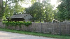 | Lincoln Pioneer Village | district | 1998 | 98000305 |
| Rockport Historic District | district | 2019 | 100004359 | |
 | Mathias Sharp House | building | 1983 | 83000148 |
 | Spencer County Courthouse | building | 1999 | 99000304 |
 | St. Boniface Church | building | 1980 | 80000065 |
Spencer County has 1 covered bridge on the National Register. Each is a listed structure with a federal nomination on file.
| Huffman Mill Covered Bridge | Listed 1998 |
Every wildfire the federal occurrence database records inside this county: 3 of them, burning about 96 acres. 1 started naturally and none was recorded as arson. Each settlement page carries the fires within five miles of it.
| Reported cause | Fires |
|---|---|
| Debris and open burning | 2 |
| Natural | 1 |
The five largest, by the area the report gives. None of them was recorded as arson.
| Date | Cause | Size | Reported by | Name on the report |
|---|---|---|---|---|
| 6 April 2001 | Debris and open burning | 95 acres | Hoosier National Forest | NEWTONVILLE |
| 17 July 2002 | Debris and open burning | 1.0 acres | Indiana State Fire Marshal's Office | not named |
| 13 April 2018 | Natural | under an acre | Lincoln Boyhood National Memorial | DRACH |
Every settlement page carries the fires within five miles of it - see the settlement index below.
The NOAA Storm Events Database holds 335 reports for this county, causing no deaths, 3 injuries and about $4,015,250 in recorded property damage. Each settlement page carries the reports that name it.
| Kind of event | Reports |
|---|---|
| Thunderstorm Wind | 154 |
| Hail | 75 |
| Flash Flood | 32 |
| Flood | 30 |
| Heavy Rain | 19 |
| Tornado | 18 |
| Funnel Cloud | 6 |
| Lightning | 1 |
The most serious of them, by death, then injury, then recorded damage. The accounts are quoted exactly as the forecast office filed them.
| When | Event | Place named | Harm | What the report says |
|---|---|---|---|---|
| April 1985 | Thunderstorm Wind | not stated | 2 hurt | no account filed |
| February 2007 | Lightning | Newtonville | 1 hurt, $5,000 | A stray bolt of lightning from an isolated storm entered a house through the telephone line. A 64-year-old man was knocked across his living room. Almost every window was shattered. The television set exploded. The man received a concussion and a damaged eardrum. |
| May 2004 | Flash Flood | Dale | $1,100,000 | no account filed |
| March 2008 | Flood | Richland | $250,000 | Three young boys were rescued unhurt when their boat capsized in Anderson River backwaters just southeast of New Boston. Several stranded motorists were rescued. At least one family was rescued from a flooded home in St. Meinrad. A home near the Anderson River was sandbagged. Schools were closed. Numerous roads were closed, including roads that don't normally flood. Major roads that were closed included portions of U.S. Highway 231, Indiana 62, and Indiana 161. Some damage occurred to county roads. Some water entered the Spencer County courthouse and other structures around the county. Residents of a house on Indiana 66 could access their house only by boat. |
| March 2018 | Flood | Pueblo | $200,000 | Moderate flooding continued along the Ohio River from late February. The flood crest in neighboring Warrick County was the highest since the March, 1997 flood. Numerous roads were closed for days at a time, including at least 50 county roads. U.S. Route 231 north of Rockport was affected by high water, along with a few other state highways. The town of Grandview in Spencer County was hardest hit, where some residents evacuated. |
| April 1996 | Thunderstorm Wind | Dale | $200,000 | no account filed |
| July 2018 | Thunderstorm Wind | Hatfield | $100,000 | A damaging downburst crossed into Spencer County from southeast Warrick County. Hundreds of trees, some very large, were uprooted, snapped, or had large broken limbs. A half dozen homes or garages sustained mostly minor damage, with loss of siding, shingles, or other damage. One barn was destroyed east of Hatfield due to fallen trees. A tree fell on a mobile home. Peak winds in this downburst were estimated near 95 mph. The damage area was about eight miles long and two miles wide, and nearly all of it occurred in Spencer County. |
| June 2011 | Thunderstorm Wind | Eureka | $100,000 | A heat burst occurred in the wake of a line of thunderstorms. About two miles east of Hatfield on Route 66, a large fertilizer auger leg was blown down off a fertilizer storage building. The building sustained minor structural damage to a section of the roof, as well as some limited loss of shingles. Five empty fertilizer wagons were blown up to 100 feet. Several tree limbs were blown down. Peak winds were estimated near 90 mph. The damage area was only about one-quarter mile long and one-quarter mile wide. A heat burst is defined as a localized, sudden increase in surface temperature associated with a thunderstorm, shower, or mesoscale convective system. This heat burst occurred approximately an hour or less following an intense area of thunderstorms that moved through the area. Two witnesses outside during the heat burst experienced temperatures which they believed to be around 100 degrees. The extreme temperatures were said to have only lasted seconds before quickly falling. Heat bursts almost invariably form on the trailing edge of thunderstorm systems. Heat bursts are extremely rare, and this one was especially rare because most heat bursts occur at night. About three miles southeast of Eureka, a trained spotter observed debris in the air above a bending tree line to the south. The wind was accompanied by a roaring sound. This was likely the same heat burst or closely associated with the one near Hatfield. |
| January 2008 | Thunderstorm Wind | Rockport | $100,000 | Countywide, trees and power lines were down. Minor structural damage occurred, with damage to roofs and outbuildings. |
| February 2018 | Flood | Pueblo | $80,000 | Moderate flooding occurred along the Ohio River. The flood crest in neighboring Warrick County was the highest since the March, 1997 flood. Numerous roads were closed for days at a time, including at least 50 county roads. U.S. Route 231 north of Rockport was affected by high water, along with a few other state highways. The town of Grandview in Spencer County was hardest hit, where some residents evacuated. |
| November 2017 | Tornado (EF1) | Lake Mill | $70,000 | The tornado touched down about one-half mile north of Indiana Route 66, on the north side of Reo. The tornado lifted about 2.5 miles northeast of Reo. A dozen trees were uprooted or snapped. A detached garage was blown down. Around a half dozen barns and sheds experienced loss of metal roofing. At least a half dozen homes sustained shingle or fascia damage. Maximum winds were estimated near 90 mph. |
| June 2011 | Thunderstorm Wind | Grandview | $70,000 | A two-mile wide swath of damaging winds occurred in extreme southeast Spencer County. There was evidence of embedded areas of brief rotation or gustnadoes, where wind speeds increased to around 80 mph, snapping large limbs and uprooting trees. A gustnado is a ground-based rotating column of air that is not rooted in the storm cloud. In Grandview, wind damage was mostly to trees and power lines. Some roof damage occurred. A fire station door was damaged. The damage path continued into Perry County. |
| June 2018 | Flash Flood | Chrisney | $60,000 | Multiple vehicle water rescues were conducted. Numerous roads were covered by water, including Highway 70, Highway 62 near 75W, County Road 1400N, and County Road 1600N just east of Santa Claus. Some flooded roads were closed through the morning hours. Radar rainfall estimates were from 3 to 4.5 inches across much of Spencer County. |
| April 2011 | Thunderstorm Wind | Hatfield | $60,000 | A roof was blown off near Hatfield. Significant damage was reported to a house between Chrisney and Hatfield. The occupants were trapped but not injured. A water rescue team was called to the house due to three to four feet of water surrounding it. State Route 161 was blocked by downed trees. |
| June 2011 | Thunderstorm Wind | Dale | $60,000 | A utility pole was broken. Road signs were blown away at the intersection of Highway 62 and U.S. Highway 231. A temporary mobile cable transmission tower was blown over. |
| June 2011 | Tornado (EF1) | St Meinrad | $60,000 | The tornado touched down on the southern end of the St. Meinrad Seminary grounds, destroying a cinder block outbuilding and taking 100 feet of roofing off a large metal outbuilding. The tornado also uprooted numerous trees and ripped sections of roofing off several other buildings before moving off to the east-northeast. Peak winds were estimated between 95 and 100 mph. The tornado continued into Perry County. |
| May 2004 | Thunderstorm Wind | Countywide | $60,000 | no account filed |
| March 2023 | Tornado (EF1) | Dale | $50,000 | An EF-1 tornado began just northeast of the community of Dale, IN, in northern Spencer County. Near the intersection of Spencer County Roads 2100 North and 500 East, a large barn had about half of its roof removed. A nearby house had its west facing windows blown in, suffered shingle and fascia damage, and an adjacent TV antenna was bent at its base parallel to the ground. Crossing Interstate 64, the tornado overturned a semitrailer about one mile east of the interchange with US 231. Along the Spencer-Dubois County line, several large trees were snapped at the base or uprooted. Additionally, a couple of homes received minor roof and fascia damage. Peak winds were estimated near 95 mph. The tornado continued moving into Dubois County. |
| December 2018 | Tornado (EF1) | Mariah Hill | $50,000 | At least three homes sustained minor damage. The damage was mostly to roofs and fascia. One garage door and a window were blown in. A detached garage was destroyed, with the debris thrown at least 300 yards. An outdoor storage shed was pushed several feet off its foundation. Minor roof damage occurred to at least three metal farm buildings. At least two dozen trees and limbs were snapped or uprooted. Peak winds were estimated near 105 mph. |
| April 2015 | Thunderstorm Wind | New Boston | $50,000 | Trees were down on a house. |
| May 2011 | Thunderstorm Wind | Rockport | $50,000 | Trees and power lines were blown down in Rockport. Roofs were damaged in Grandview, and fire station doors were damaged. |
| May 1996 | Tornado (F1) | Dale | $50,000 | no account filed |
| November 1993 | Thunderstorm Wind | Dale | $50,000 | no account filed |
| October 2021 | Tornado (EF1) | Gentryville | $45,000 | Where the initial damage was observed, several trees were snapped on County Road 1250N at a railroad crossing about a mile west of Highway 231. The tornado tracked about a mile northeast and impacted a residence on County Road 275E. At this residence, a large barn was pushed back about 20 feet off its foundation. At the property next to this barn, a large tree was snapped at its base and fell onto the house. The corn field next to this house had some swirls in the flattened corn. Peak winds were estimated near 90 mph. |
| July 2016 | Thunderstorm Wind | Richland | $40,000 | Trees were blown down in and near Richland. Two miles west of Rockport along State Route 66, there was roof and siding damage to homes, and a large playhouse was turned on its side. |
| May 2006 | Thunderstorm Wind | Dale | $40,000 | The roof was blown off a home, and its walls were damaged. A barn was destroyed. The damage area was 150 feet by 200 feet. The damage was located about one quarter mile south of the Interstate 64 junction with U.S. 231. |
| February 1999 | Thunderstorm Wind | Richland | $40,000 | Two barns were destroyed, one in Richland City and the other 3 miles northeast of Richland City. A grain auger was destroyed, and there was sign damage at a co-op in town. A small block building was blown apart. The roof was blown 50 to 75 feet away. Numerous trees were snapped or uprooted. All debris was blown in a northeast direction. |
| June 1998 | Thunderstorm Wind | Dale | $40,000 | Numerous trees and tree limbs were downed across northern Spencer County. Homes and buildings were damaged by toppled tree limbs near Dale and Santa Claus. A roof was torn off a home near St. Meinrad. |
| March 2023 | Thunderstorm Wind | Rockport | $35,000 | Trees were blown down in Rockport. Three power poles were down along with trees down on Highway 161 just north of Owensboro. |
| June 2023 | Thunderstorm Wind | Grandview | $35,000 | Semis were blown over on U.S. Highway 231 in Rockport. Numerous trees were snapped or uprooted in Grandview. |
| June 2023 | Thunderstorm Wind | Pigeon | $30,000 | A horse barn was destroyed just inside the Spencer County line east of Tennyson. |
| July 2019 | Thunderstorm Wind | Richland | $30,000 | An emergency manager reported a microburst north of the community of Reo. The damage path was about a mile and a half long. The damage started at the intersection of County Roads 450W and 400N. Many trees and five power poles were snapped. A peach crop was destroyed. |
| February 2014 | Thunderstorm Wind | Santa Claus | $30,000 | A fence and an outdoor building were blown over. Several trees and power lines were down. |
| May 2011 | Flood | Africa | $30,000 | no account filed |
| June 2024 | Thunderstorm Wind | Santa Claus Muni Arp | $25,000 | A localized enhanced thunderstorm downburst resulted in a barn roof being blown off and several trees downed near E County Rd 1200 N. |
| April 2024 | Thunderstorm Wind | Chrisney | $25,000 | A storm line moving eastward across the county snapped utility poles in Chrisney. |
| April 2023 | Tornado (EF0) | Centerville | $25,000 | An EF-0 tornado impacted portions of rural Spencer County southwest of Chrisney. The primary damage caused by the tornado was downing several large tree limbs, as well as snapping or uprooting a few trees. The tornado knocked down the walls of a barn near the intersection of County Road 700 North and Old US Highway 231. Peak winds were estimated near 85 mph. |
| March 2022 | Thunderstorm Wind | Chrisney | $25,000 | Three utility poles were snapped near County Road 900 North. |
| May 2014 | Thunderstorm Wind | Buffaloville | $25,000 | Very high straight-line winds estimated near 95 mph carved a west to east corridor of damage through northern Spencer County. This corridor passed through the Santa Claus area. The affected area was very rural. Metal roofing was peeled off a portion of a large barn. Numerous large trees were uprooted and snapped. |
| April 2011 | Thunderstorm Wind | New Boston | $25,000 | Near New Boston, a barn was destroyed, and trees were down. |
| May 1982 | Tornado (F0) | not stated | $25,000 | no account filed |
| June 2023 | Thunderstorm Wind | Dale | $20,000 | Shingles were blown off a home. A tree was down on a truck. |
| September 2018 | Flash Flood | Dale | $20,000 | State Highway 66 was flooded west of Rockport. Water was over Highway 245 south of Santa Claus. Numerous county roads were flooded across the county. High water was over County Road 1600N near Santa Claus. Several water rescues were conducted due to stranded vehicles. |
| July 2017 | Thunderstorm Wind | Chrisney | $20,000 | Numerous trees were down across northwestern parts of the county. Interstate 64 was blocked for a time. |
| June 2013 | Thunderstorm Wind | Grandview | $20,000 | A wind gust to 62 mph was measured in Rockport. Trees and power lines were blown down in Grandview and Rockport. |
| March 2008 | Flood | Rockport | $20,000 | Minor flooding of the Ohio River occurred. At the Owensboro, KY gage, the river crested at 43.3 feet on March 23. Flood stage there is 40 feet. Floodwaters entered the basements of houses along the river's edge below the Rockport bluff. Water covered the parking lot and park road in Grandview. Low-lying fields near the river were flooded. |
| April 1996 | Flash Flood | Rockport | $20,000 | no account filed |
| July 2019 | Thunderstorm Wind | Dale | $15,000 | Minor structural damage occurred to farm outbuildings. |
| January 2013 | Thunderstorm Wind | Rockport | $15,000 | A concrete garage was destroyed. |
| July 2002 | Thunderstorm Wind | Dale | $15,000 | A thunderstorm microburst, containing winds estimated near 90 MPH, destroyed a two-story barn just off Highway 245 between Dale and Santa Claus. Three cattle were killed and 11 others injured. About five miles to the northwest, another barn was reportedly destroyed. |
| May 1999 | Thunderstorm Wind | Countywide | $15,000 | A utility company reported trees and power lines down at locations scattered around the county. Steel siding was blown off a building at Rockport. |
| July 1995 | Thunderstorm Wind | Countywide | $15,000 | Numerous trees and power lines were blown down across the county. |
| July 2025 | Flash Flood | Rockport | $10,000 | Significant flash flooding occurred in Rockport due to hourly rainfall totals reaching radar estimated amounts of 2-2.5 in and around Rockport. The report was relayed on social media. |
| June 2023 | Thunderstorm Wind | Grandview | $10,000 | In Rockport, a garage roof was damaged by a tree falling onto it. Multiple trees were down in the Grandview area. |
| August 2022 | Flash Flood | Santa Claus | $10,000 | Several inches of water flowed through a campground in Santa Claus. Roads were flooded in the northern part of the county, including County Road 1600 North near Santa Claus and Monte Casino Road north of St. Meinrad. |
| June 2019 | Thunderstorm Wind | Rockport | $10,000 | Trees and power lines were down. |
| May 2018 | Thunderstorm Wind | Santa Claus | $10,000 | Tree damage was reported between Santa Claus and Dale. |
| December 2018 | Thunderstorm Wind | Mariah Hill | $10,000 | A small number of shingles were blown off a well-constructed house. A few farm outbuildings suffered varying degrees of roof damage, mainly sheets of tin blown off. Several trees were uprooted. This wind damage occurred just prior to the start of a tornado path. The beginning of the tornado path was only 500 yards from the closest damage from this downburst. |
| November 2017 | Thunderstorm Wind | Rockport | $10,000 | A tractor-trailer rig was blown over on U.S. Highway 231. |
| July 2017 | Thunderstorm Wind | Newtonville | $10,000 | Several trees were blown down on Highway 70 east of Newtonville. At least one tree was down near Grandview. Power outages were reported in the area. |
The Survey's mineral resources record lists 2 workings inside this county. All of them still produce. Each settlement page carries the workings within five miles of it.
| Commodity | Workings |
|---|---|
| Sand and Gravel, Construction | 1 |
| Stone | 1 |
The least common of them first, because a county's hundredth gravel pit says nothing its first ten did not.
| Where | Site | Commodity | Status | Recorded |
|---|---|---|---|---|
| Rockport Plant | Sand and Gravel, Construction | Producer | ||
| Spencer Co. Hwy. Dept. | Stone | Producer |
Named settlements recorded in the Geographic Names Information System, each with the topographic sheets covering it. Villages, hamlets and abandoned places alike. Each is shown with the nearest named watercourse or landform and the survey quadrangle it falls on.
Grass township · 47635 · Near Fisher Knobs · Rockport quadrangle
17 sheets, 1901 to 1991
Huff township · 47531 · On Middle Fork Crooked Creek · Fulda quadrangle
15 sheets, 1900 to 1994
Luce township · 47634 · On Hatfield Drain · Richland City quadrangle
16 sheets, 1901 to 1991
Ohio township · 47635 · On Garrett Creek · Rockport quadrangle
17 sheets, 1901 to 1991
Harrison township · 47532 · On Abbey Run · Saint Meinrad quadrangle
16 sheets, 1900 to 1994
Ohio township · 47635 · On Hurricane Creek · Owensboro East quadrangle
18 sheets, 1901 to 1991
Jackson township · 47637 · On Little Pigeon Creek · Chrisney quadrangle
18 sheets, 1900 to 1986
Harrison township · 47577 · On Abbey Run · Saint Meinrad quadrangle
16 sheets, 1900 to 1994
Ohio township · 47635 · On Hurricane Creek · Owensboro East quadrangle
18 sheets, 1901 to 1991