 Block
Brick Chapel, Indiana
14 topographic sheets cover this place, the earliest surveyed in 1953 and the latest in 1986. It stands in Monroe Township. It lies in ZIP code area 46135. The Survey maps it on the Greencastle quadrangle.
On record in Brick Chapel
Buildings and businesses the archive holds for this place. Each opens its own page, with the source record it came from.
On the National Register 1 record
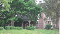 James Edington Montgomery O'Hair Houselisted 1992
Topographic sheets covering this place
7 surveys from 14 printed sheetsMatched by testing this settlement's coordinate against the published boundary of every sheet in the United States Geological Survey's historical collection. Each opens the scanned sheet at the Survey.
- 1953 USGS Indianapolis quadrangle1:250000, 4 printings
- 1956 USGS Indianapolis quadrangle1:250000
- 1957 USGS Indianapolis quadrangle1:250000, 2 printings
- 1958 USGS Greencastle quadrangle1:24000
- 1962 USGS Indianapolis quadrangle1:250000
- 1970 USGS Greencastle quadrangle1:24000, 3 printings
- 1986 USGS Indianapolis quadrangle1:100000, 2 printings





In the county-history sources
741 words on this townshipBiographical and Historical Record of Putnam County, Indiana .., published 1887 names this settlement in its chapter on Monroe Township. These are the passages that mention it, exactly as the scans read.
The first settlers were Jesse and Rollin James, Elias Gibson and John Powell, who built their cabins in 1821,m the- west part of the township, not far from where Brick Chapel now stands. In 1822 came Isaiah Vermillion, Thomas Head}-, Barnabas Frakes, George W. Hewlett and Philip Ford. During the next two years Levi Stewart, .John, Abner and O. Goodwin and George Pearcy became citizens. Within the years 1825 and 1820 they were joined by William Randall, James W. Hillis, Joseph Logan, Mr. McCorkle, William II. Thornburg, Andy Sigler, Captain Tumbrick, Jonathan, Aaron and Henry Myers, Mr. Glover, John and George Jackson, Mr. Baileys, Thomas Benge, "William Moss, Reuben Slavens, Edward Parish, Andrew Byerly, Joseph Heath, Philip Slater, Hudson and Eli Brackney, Robert N. Allen, Thomas Starks, Mr. Busey, John Allen, Mr. Penny, Abraham Leatherinan and Luke Gardner. The years 1827 and 1828 mark the arrival of Robert C. Brown, Addison and Josiah Lane, Samuel Job, Elswick Risk, George Gibson, John F rakes, J. and P. Clement and W. Hansel. There was a large increase of population in the following two years, among whom were James Montgomery, Daniel Chadd, James Fisk, Phelan and Corbin Priest, dames O'Hair, John Brown, Henry Foster, Alexander Tolin, PeterGraves, John Gilkey, Hiram B. Slavens,
Passage source: Biographical and Historical Record of Putnam County, Indiana .., published 1887.
Alexander Farrow, Thomas Tinsley, William Garrett, Sharp Spencer, Mrs. Brother* and her: son Robert lb-others ami Mr. Dale. Among those who came soon afterward may be named the Darnal'ls, 'the Starrs, the Thorntons and the Fyffes.
Passage source: Biographical and Historical Record of Putnam County, Indiana .., published 1887.
The marriage of George Jackson and Susannah Tomlinson was the first in the township. The first blacksmith was John Jackson, who built a shop on section 32. Thomas Heady Was the first justice of the peace. Then came Reuben Slavens and Alexander Tolin as his successors in office. The first who died in the township was a man named Lane. He was buried on the farm of George W. Hewlett. The Brick Chapel graveyard is one of the oldest in the township, and has a beautiful 'location. The first school was taught by George Pearcy on section 1, north of Bainbridge. About the year 1826 Addison 'Lane taught a school near the site of Brick Chapel, which was the first in that neighborhood. He was followed by Joseph Farley, Hiram B. Slavens and John Slavens. The Christians held the first meetings in the township at the house of George W. Hewlett in 18^3. Gilbert llaniey preached and conducted the services. This house was used as a place of worship for several years by different denominations. Rev. Benjamin Jones, a Methodist minister, held services also at the house of Mr. Hewlett, shortly after the Christian meetings at the same place, and here the Methodist church was organized by Daniel Anderson and Benjamin C. Stevenson. This must have taken place in the conference year 1820-'27, as Anderson and Stevenson were then pastors of the Eel River Circuit. Meetings were also held in a log schoolhouse that stood where Brick Chapel now stands. The first church-building was erected by the Methodists on the present site of the Montgomery Chapel. It was a small brick
Passage source: Biographical and Historical Record of Putnam County, Indiana .., published 1887.
Machine-read from a century-old scan, so expect the errors a machine makes: misspelled names, dropped words, stray characters.
Mines and quarries near this place
4 within 5 milesRegional context, not property-specific evidence. The federal mineral resources record lists 4 workings within 5 miles of Brick Chapel: 3 producers, 1 past producer. 3 still produce. What was taken out: Stone, Crushed/Broken, Stone, Sand and Gravel, Construction. Distance is straight-line from the map coordinates, so a quarry counted here may appear on a neighbouring settlement's page as well.
| Where | Site | Commodity | Status | Recorded |
|---|---|---|---|---|
| Bainbridge Sand and Gravel Pit | Sand and Gravel, Construction | Past Producer | ||
| Putnam Co. Hwy. Dept. | Stone | Producer | ||
| Harris Stone Service Inc | Stone, Crushed/Broken | Producer | ||
| Lone Star Greencastle Quarry | Stone, Crushed/Broken | Producer |
Storms near this place
12 since 2008Regional context, not property-specific evidence. The National Weather Service names Brick Chapel in 12 storm reports between 2008 and 2025: 9 thunderstorm wind, 1 flood, 1 hail, 1 flash flood. No death or injury is recorded in these reports. Each account below is quoted exactly as the forecast office filed it, from the NOAA Storm Events Database, and each date opens the federal record of that event.
| When | Event | Place named | Harm | What the report says |
|---|---|---|---|---|
| February 2008 | Thunderstorm Wind | Brick Chapel | $30,000 | Severe thunderstorm winds blew the roof off of a historic barn. The barn was a total loss. |
| June 2011 | Thunderstorm Wind | Brick Chapel | $20,000 | A tree was downed on a car on State Route 231, three miles south of Highway 36, due to damaging thunderstorm wind gusts. Multiple power lines were downed in the northern part of the county. Multiple trees were down as well. |
| February 2008 | Thunderstorm Wind | Brick Chapel | $20,000 | Three miles north of Greencastle on Route 231 a structure sustained significant damage due to damaging thunderstorm winds. Debris was spread across Route 231 and due to this debris the road was closed. |
| March 2025 | Thunderstorm Wind | Brick Chapel | $10,000 | Thunderstorm winds downed roof and siding material off of a barn on US 231 in Brick Chapel. |
| May 2018 | Thunderstorm Wind | Brick Chapel | $10,000 | Power lines were knocked down by downed trees that were blocking the road due to damaging thunderstorm wind gusts. |
| May 2018 | Thunderstorm Wind | Brick Chapel | $4,000 | A road was blocked by downed trees due to damaging thunderstorm wind gusts. |
| May 2018 | Thunderstorm Wind | Brick Chapel | $1,000 | Tree limbs of 1 to 2 inches in diameter were snapped with some roof shingles stripped from houses due to strong thunderstorm wind gusts. |
| June 2015 | Flash Flood | Brick Chapel | $1,000 | Water was reported to be over the roadway near County Roads 200 West and 450 North from nearby Falls Branch Creek. This event occurred due to heavy thunderstorm rainfall. |
| May 2018 | Thunderstorm Wind | Brick Chapel | - | A thunderstorm wind gust was measured at 59 mph by an instrument on a vehicle. This observation came while the vehicle was on County Road 350 North. |
| May 2009 | Flood | Brick Chapel | - | Six inches of rain water was reported on County Road 350 North near the intersection of County Road 225 West. |
| July 2008 | Thunderstorm Wind | Brick Chapel | - | Thunderstorm winds blew down a tree onto United States Highway 231, fully blocking the road. Nearby, Shortcut Road was said to have been almost impassible right after the storm. |
| March 2012 | Hail | Brick Chapel | - | no account filed |
Nearest settlements
The eight closest, with where each one stands in the county. Distances are straight-line, computed from the Geographic Names Information System coordinates.
| Map | Place | Distance | Sheets |
|---|---|---|---|
| Cary | 2.5 miles | 14 | |
| Van Bibber Lake | 3.3 miles | 14 | |
| Bainbridge | 4.6 miles | 11 | |
| Greencastle | 4.6 miles | 14 | |
| Morton | 5.0 miles | 13 | |
| Clinton Falls | 5.0 miles | 14 | |
| Fox Ridge | 5.6 miles | 14 | |
| Edgewood Lake | 6.2 miles | 14 |
Provenance
This settlement is recorded in the Geographic Names Information System as feature 449622. The sheet list is computed by point-in-boundary test against the United States Geological Survey's historical topographic inventory. Both are works of the United States government and carry no copyright under 17 U.S.C. 105.
Mines and quarries. USGS Mineral Resources Data System (MRDS) https://mrdata.usgs.gov/mrds/ A work of the United States government, no copyright under 17 U.S.C. 105.
Storms. NOAA National Centers for Environmental Information, Storm Events Database https://www.ncei.noaa.gov/stormevents/ A work of the United States government, no copyright under 17 U.S.C. 105. Narratives are quoted verbatim from the National Weather Service report and are not edited or summarised.