 Block
Elkhart, Indiana
13 topographic sheets cover this place, the earliest surveyed in 1953 and the latest in 1985. It stands in Concord Township. It lies in ZIP code area 46516. It stands on Christiana Creek. The Survey maps it on the Elkhart quadrangle. 53,923 people lived here at the 2020 count. It stands 748 feet above sea level.
On record in Elkhart
Buildings and businesses the archive holds for this place. Each opens its own page, with the source record it came from.
On the National Register 12 of 17 shown
 Baugo Township Gymnasiumlisted 2016
 Beardsley Avenue Historic Districtlisted 2003
 Albert R. Beardsley Houselisted 1978
 Dr. Havilah Beardsley Houselisted 2000
 Emmanuel C. Bickel Houselisted 1979
 Bridge Street Bridgelisted 2009
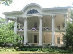 Charles Gerard Conn Mansionlisted 2007
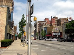 Elkhart Downtown Commercial Historic Districtlisted 1997
 Green Blocklisted 1980
 William and Helen Koerting Houselisted 2009
 Lerner Theatrelisted 1980
 Mark L. and Harriet E. Monteith Houselisted 1985
Population over time
2 figuresElkhart grew from 50,949 to 53,923 between 2010 and 2020. These are the recorded population figures Wikidata holds for this place, reached through the Geographic Names Information System number this page is keyed on rather than by name, so they belong to this place and not to another of the same name. Most are census counts, but not all are: an early figure may be a founding or settlement estimate, and an estimate published within five years of a census is left out. The change column is computed, and is left blank where more than 20 years separate a figure from the one before it, because a gap that long is not a change between two counts.
| Year | People | Change |
|---|---|---|
| 2010 | 50,949 | |
| 2020 | 53,923 | +2,974 (+6%) |
Topographic sheets covering this place
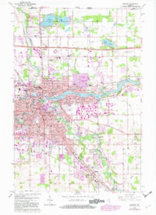
4 surveys from 13 printed sheetsMatched by testing this settlement's coordinate against the published boundary of every sheet in the United States Geological Survey's historical collection. Each opens the scanned sheet at the Survey.
- 1953 USGS Fort Wayne quadrangle1:250000, 4 printings
- 1956 USGS Fort Wayne quadrangle1:250000, 2 printings
- 1961 USGS Elkhart quadrangle1:24000, 5 printings
- 1985 USGS Elkhart quadrangle1:100000, 2 printings


Mines and quarries near this place
3 within 5 milesRegional context, not property-specific evidence. The federal mineral resources record lists 3 workings within 5 miles of Elkhart: 2 unknowns, 1 producer. 1 still produces. What was taken out: Sand and Gravel, Construction. Distance is straight-line from the map coordinates, so a quarry counted here may appear on a neighbouring settlement's page as well.
| Where | Site | Commodity | Status | Recorded |
|---|---|---|---|---|
| Hunterlake Pit | Sand and Gravel, Construction | Unknown | ||
| Pit No. 3 | Sand and Gravel, Construction | Producer | ||
| Riegsecker Pit | Sand and Gravel, Construction | Unknown |
Storms near this place
60 of 105 shownRegional context, not property-specific evidence. The National Weather Service names Elkhart in 105 storm reports between 1994 and 2025: 68 thunderstorm wind, 29 hail, 3 lightning, 2 tornado. The reports record 5 injuries. Each account below is quoted exactly as the forecast office filed it, from the NOAA Storm Events Database, and each date opens the federal record of that event.
| When | Event | Place named | Harm | What the report says |
|---|---|---|---|---|
| October 2001 | Tornado (F0) | Elkhart | 3 hurt, $936,000 | Tornado touched down southeast of Mishawaka and traveled northeast through the west side of Osceola before moving into Elkhart county northeast of Osceola. F2 damage occurred between Mishawaka and Osceola. The tornado then skipped as it went into Elkhart county causing F0 damage in the Cobus Green mobile home park before lifting. |
| June 2017 | Lightning | Elkhart | 1 hurt | Local media reported lightning struck a tree, injuring a person standing next to it. |
| August 2001 | Lightning | Elkhart | 1 hurt | A 24-year old male was struck by lightning at Flexco Products at 2415 Bryant Street in Elkhart. |
| July 2024 | Tornado (EF1) | Elkhart | $500,000 | A survey of damage confirmed a brief tornado, embedded within an area of straight line wind damage. The tornado touched down southeast of Hawthorne Elementary School and proceeded quickly east-southeast. Numerous trees were uprooted, partially due to the wet ground conditions, as well as several snapped tree limbs and trunks. The greatest damage occurred in the area of Mather Ave, between Carlton Ave and Naomi St. |
| March 2025 | Thunderstorm Wind | Elkhart | $300,000 | There were 30 homes with trees down on them around the city of Elkhart. |
| August 1998 | Thunderstorm Wind | Elkhart | $250,000 | EXTENSIVE TREE AND POWER LINE DAMAGE OCCURRED ACROSS THE ENTIRE COUNTY. SEVERAL BUILDINGS AND CARS IN DOWNTOWN GOSHEN SUSTAINED MINOR TO MODERATE STRUCTURAL DAMAGE DUE TO LARGE TREES AND LIMBS CRASHING DOWN. BUSINESSES ON THE EAST SIDE OF GOSHEN ALONG HIGHWAY 33 SUSTAINED DAMAGE. THE HOLIDAY INN HAD PART OF ITS ROOF BLOWN OFF. LOCAL BANK HAD ITS STEEL BANK SIGN FLATTENED. |
| March 2006 | Thunderstorm Wind | Elkhart | $25,000 | Trees and power lines were reported down throughout the county. |
| July 2011 | Thunderstorm Wind | Elkhart | $15,000 | A local newspaper reported a large tree fell into the center of a home in Penton Court. Damage is estimated at $15,000. |
| August 2007 | Thunderstorm Wind | Elkhart | $15,000 | Newspaper reported a large tree fell onto a SUV occupied by a mother and son, near the intersection of Johnson St and Sunset Ave. The driver's side of the vehicle was damaged but no serious injuries were reported. Damage is estimated at $15,000. |
| June 2024 | Thunderstorm Wind | Elkhart | $10,000 | Numerous reports of trees down and large limbs down in and around Elkhart. One tree was reportedly struck by lightning. |
| July 2022 | Thunderstorm Wind | Elkhart | $10,000 | A very large tree uprooted onto a house. |
| July 2011 | Thunderstorm Wind | Elkhart | $10,000 | A local newspaper reported that at least 10 trees were snapped or uprooted at a residence. One of these fell onto a home causing some roof damage, estimated at $10,000. |
| July 2004 | Thunderstorm Wind | Elkhart | $7,500 | Damage to roof of city of Elkhart street department building. |
| March 2025 | Thunderstorm Wind | Elkhart | $5,000 | Estimated 70 mph wind gusts at the corner of Wolf St and Frances Ave. Uprooted trees and broken branches in the area. |
| May 2000 | Thunderstorm Wind | Elkhart | $5,000 | Roof damage. Tree fell on car. Many trees and power lines down. |
| May 1999 | Thunderstorm Wind | Elkhart | $5,000 | Power lines down on Beardsley Rd. between Main and Cassopolis. Several trees blown down in Sturdy Oaks subdivision. |
| August 2021 | Thunderstorm Wind | Elkhart | $3,000 | The public reports numerous trees and large branches down. |
| August 2004 | Thunderstorm Wind | Elkhart | $3,000 | Amateur radio reported some windows blown out and power lines down in Elkhart. |
| March 2023 | Hail | Elkhart | $2,000 | Half dollar size hail reported. |
| March 2023 | Hail | Elkhart | $2,000 | Quarter sized hail reported. |
| August 2021 | Thunderstorm Wind | Elkhart | $2,000 | The public reports trees and powerlines down. |
| July 2023 | Hail | Elkhart | $1,000 | no account filed |
| July 2023 | Hail | Elkhart | $1,000 | no account filed |
| June 2022 | Hail | Elkhart | - | Report of quarter size hail through social media. |
| June 2021 | Thunderstorm Wind | Elkhart | - | Large trees have fallen down blocking east Blvd from Lexington. Blocking traffic to Elkhart General ER. |
| June 2021 | Flood | Elkhart | - | Heavy rain reported from MPing. |
| August 2021 | Thunderstorm Wind | Elkhart | - | The media reports a large tree down, and estimated 60 mph wind. |
| August 2021 | Thunderstorm Wind | Elkhart | - | Tree limb downed. |
| July 2019 | Thunderstorm Wind | Elkhart | - | The public reported large tree limbs and power lines down south of the intersection of Goshen Ave and Toledo Rd. |
| August 2018 | Thunderstorm Wind | Elkhart | - | A trained spotter reported several smaller tree branches down. |
| May 2018 | Thunderstorm Wind | Elkhart | - | The public estimated wind gusts to 60 mph as well as dime size hail. |
| March 2017 | Thunderstorm Wind | Elkhart | - | A trained spotter estimated wind gusts to 60 mph. |
| July 2017 | Thunderstorm Wind | Elkhart | - | The public reported a tree was blown down onto a house. |
| June 2016 | Thunderstorm Wind | Elkhart | - | County dispatch reported trees down in the city. |
| June 2015 | Flood | Elkhart | - | Street flooding of 6 to 8 inches in Elkhart. |
| June 2015 | Hail | Elkhart | - | Dime to penny sized hail. |
| June 2015 | Hail | Elkhart | - | Pea to penny sized hail with winds estimated at 35 mph. |
| July 2015 | Thunderstorm Wind | Elkhart | - | Eighteen inch diameter tree down at the intersection of Bristol Street and Osolo Road. |
| July 2015 | Thunderstorm Wind | Elkhart | - | Tree limbs and power lines downed. |
| June 2014 | Thunderstorm Wind | Elkhart | - | The public reported a tree was blown down onto a home. |
| June 2014 | Thunderstorm Wind | Elkhart | - | Local newspapers reported trees and power lines were blown down across Elkhart. |
| July 2014 | Thunderstorm Wind | Elkhart | - | Reports of estimated wind gusts to 60 mph were received. |
| June 2013 | Thunderstorm Wind | Elkhart | - | Multiple power lines, some arcing, were reported down near Francis and Blaine Street. |
| November 2013 | Thunderstorm Wind | Elkhart | - | The public reported multiple trees down in the city. |
| August 2012 | Thunderstorm Wind | Elkhart | - | The public reported large branches down near County Road 1. |
| August 2012 | Thunderstorm Wind | Elkhart | - | A trained spotter estimated a wind gust to 65 mph. |
| June 2012 | Thunderstorm Wind | Elkhart | - | A trained spotter reported numerous four inch diameter tree limbs down in the area of State Route 15 and U.S. 20. |
| May 2011 | Thunderstorm Wind | Elkhart | - | Law enforcement officials reported widespread tree and power line damage across the county. |
| June 2011 | Thunderstorm Wind | Elkhart | - | Law enforcement officials reported trees and power lines down throughout the northwestern part of the county, including portion of the city of Elkhart. |
| July 2010 | Thunderstorm Wind | Elkhart | - | A trained spotter recorded a 72 mph wind gust on the west side of Elkhart. |
| June 2010 | Thunderstorm Wind | Elkhart | - | Amateur radio operator estimates wind gusts of up to 60 mph. |
| June 2010 | Thunderstorm Wind | Elkhart | - | A 24 inch diameter tree was down on 1700 block of S Main Street. |
| April 2008 | Thunderstorm Wind | Elkhart | - | Local law enforcement reported a tree down blocking the road near the intersections of County Roads 9 and 32. |
| June 2008 | Hail | Elkhart | - | Amateur radio operators reported quarter size hail on the north side of town. |
| July 2008 | Thunderstorm Wind | Elkhart | - | Law enforcement officials reported several trees down in Elkhart. |
| May 2006 | Hail | Elkhart | - | The Great Lakes RV Center had several trailers that were struck by hail up the size of quarters. Many of them had reinforced metal on the sides, which kept damage very limited. However, 3 of the RV's has thinner metal, resulting is damage along the sides where the hail struck. |
| May 2006 | Hail | Elkhart | - | Golf ball size hail reported on the southside of Elkhart. |
| June 2004 | Thunderstorm Wind | Elkhart | - | Law enforcement reported several trees down in Elkhart. |
| May 2004 | Thunderstorm Wind | Elkhart | - | Amateur radio reported an estimated wind gust to around 70 MPH north of Elkhart. |
| August 2004 | Thunderstorm Wind | Elkhart | - | Amateur radio reported trees down northwest of Elkhart. |
Nearest settlements
The eight closest, with where each one stands in the county. Distances are straight-line, computed from the Geographic Names Information System coordinates.
| Map | Place | Distance | Sheets |
|---|---|---|---|
| Greenleaf Manor | 2.4 miles | 13 | |
| East Lake Estates | 2.7 miles | 13 | |
| De Camp Gardens | 3.3 miles | 13 | |
| Garden Village | 3.4 miles | 13 | |
| Jamestown | 4.0 miles | 13 | |
| Dunlap | 4.2 miles | 13 | |
| Simonton Lake | 5.0 miles | 16 | |
| Midway | 6.3 miles | 12 |
Elsewhere
Matched on this settlement's Geographic Names Information System number rather than its name, so it cannot be a different place of the same name in another state.
| Wikipedia article on Elkhart | An encyclopaedic summary. Its text is share-alike, so it is linked here rather than copied. |
| Wikidata item Q2008706 | The structured record the population and elevation above come from. Public domain (CC0). |
Provenance
This settlement is recorded in the Geographic Names Information System as feature 434079. The sheet list is computed by point-in-boundary test against the United States Geological Survey's historical topographic inventory. Both are works of the United States government and carry no copyright under 17 U.S.C. 105.
Mines and quarries. USGS Mineral Resources Data System (MRDS) https://mrdata.usgs.gov/mrds/ A work of the United States government, no copyright under 17 U.S.C. 105.
Storms. NOAA National Centers for Environmental Information, Storm Events Database https://www.ncei.noaa.gov/stormevents/ A work of the United States government, no copyright under 17 U.S.C. 105. Narratives are quoted verbatim from the National Weather Service report and are not edited or summarised.