 Block
Mays, Indiana
9 topographic sheets cover this place, the earliest surveyed in 1953 and the latest in 1986. It stands in Center Township. It lies in ZIP code area 46155. The Survey maps it on the Mays quadrangle. It stands 1,010 feet above sea level.
On record in Mays
Buildings and businesses the archive holds for this place. Each opens its own page, with the source record it came from.
On the National Register 1 record
 Center Township Grade and High Schoollisted 2004
Topographic sheets covering this place
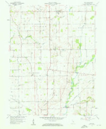
4 surveys from 9 printed sheetsMatched by testing this settlement's coordinate against the published boundary of every sheet in the United States Geological Survey's historical collection. Each opens the scanned sheet at the Survey.
- 1953 USGS Cincinnati quadrangle1:250000, 3 printings
- 1957 USGS Cincinnati quadrangle1:250000
- 1959 USGS Mays quadrangle1:24000, 3 printings
- 1986 USGS New Castle quadrangle1:100000, 2 printings



In the county-history sources
12,146 words on this townshipHistory of Rush County, Indiana, from the Earliest Time to the Present : with Biographical Sketches, Notes, Etc., Together with a Short History of the Northwest, the Indiana Territory, and the State of Indiana, published 1888 names this settlement in its chapter on Center Township. These are the passages that mention it, exactly as the scans read.
John W. Martin, merchant and grocer of Mays, was born in Chester County, Pa., February 16, 1837. He was the son of Major Benjamin L. and Sarah (Christmanj Martin, who were also natives of Chester Count}-, Pa. His father served as a Major during the late war. He was the son of John and Ruth Ann (Stevenson) Martin, who also were natives of Pennsylvania. When he was two years old his parents settled in Wavne County, this State, Avhere our subject was reared and where his parents still reside. The father, B. L. Martin, served as Auditor of Wayne County, from 1S53 to 1S61, and during the greater part of that time our subject was his deputy. In the meantime he had provided himself with a collegiate education, having spent six years in Whitewater College of Centerville. In 1861 he resigned the deputy auditorship to accept the position as deputy Secretary of State under Judge William A. Peelle. At the end of two years he entered the service of the Union Army and served in a creditable manner until the close of the war. On retiring from the service, he returned home and he was married in Aurora, this State, to Jennie J. Jones in the fall of 1866. She was born in Aurora, Ind., being the daughter of Jonathan and Sophia Jones. Shortlv after his marriage Air. Martin went to Grenada, Miss., where he was engaged in merchandising two years. He then returned to Wa^-ne County; Ind., and two 3'ears later he engaged in mercantile pursuits in Chester and Bethel, both of Wayne County. In about 1S76 he entered the employ of the Maddux Bros, of Cincinnati as traveling salesman, in which capacity he continued three }-ears. He then came to Rush County and engaged in merchandising in Raleigh, and also farming in the vicinity of that place. He continued in this way six years. By this time his health was serious!}- impaired and he retired from business and spent one 3-ear recruiting it. February i, 1887, he opened a general store in Ma}-s, this county, to which his attention is now directed. He is the father of four children, Stella A., Inez S., Alice Blanche and Jessie, all living. Mrs. Martin is a member of the Church. Mr. Martin is a member of the Masonic fraternitv and a Republican in politics. While a resident of Wayne County he served as Justice of the Peace one term. He is an intelligent man with good business qualifications and a first class citizen. His father is also an ardent Republican and has represented Wajme County, this State, two terms in the State Legislature.
Passage source: History of Rush County, Indiana, from the Earliest Time to the Present : with Biographical Sketches, Notes, Etc., Together with a Short History of the Northwest, the Indiana Territory, and the State of Indiana, published 1888.
Bedford County, Pa. Mr. and Mrs. Rhodes entered upon their married hfe upon the farm they now occupy and there they have ever since continued to reside. The hfe occupation of Mr. Rhodes has been farming, and in this connection his efforts have been hberally rewarded. They have been the foster parents of three children: The lirst was WilHam A. Schaffer, who remained with them from the age of thirteen to the age of twenty-one, when Mr. Rhodes gave him a horse, saddle and bridle, suit of clothes and $300 in money. The second child was Ettie Eagle who remained with Mr. and Mrs. Rhodes, from the time she was five years old until she became of age. The third child was Elmer Roberts, who is a nephew of Mr. Rhodes. He has now reached the age of fifteen and his home has been made with Mr. and Mrs. Rhodes ever since he was seven months old. Mr. Rhodes and wife are members of the Christian Church. In politics, Mr. Rhodes is a Democrat. He has a farm of eightj^ acres which is in a good state of improvement and cultivation.
Passage source: History of Rush County, Indiana, from the Earliest Time to the Present : with Biographical Sketches, Notes, Etc., Together with a Short History of the Northwest, the Indiana Territory, and the State of Indiana, published 1888.
Machine-read from a century-old scan, so expect the errors a machine makes: misspelled names, dropped words, stray characters.
Read the whole chapter on Center Township - it names this place 1 more 1 time.
Mines and quarries near this place
1 within 5 milesRegional context, not property-specific evidence. The federal mineral resources record lists 1 working within 5 miles of Mays: 1 producer. All of them still produce. What was taken out: Sand and Gravel, Construction. Distance is straight-line from the map coordinates, so a quarry counted here may appear on a neighbouring settlement's page as well.
| Where | Site | Commodity | Status | Recorded |
|---|---|---|---|---|
| Bells Gravel Pit | Sand and Gravel, Construction | Producer |
Storms near this place
6 since 1996Regional context, not property-specific evidence. The National Weather Service names Mays in 6 storm reports between 1996 and 2021: 4 thunderstorm wind, 1 tornado, 1 hail. No death or injury is recorded in these reports. Each account below is quoted exactly as the forecast office filed it, from the NOAA Storm Events Database, and each date opens the federal record of that event.
| When | Event | Place named | Harm | What the report says |
|---|---|---|---|---|
| August 2006 | Tornado (F0) | Mays | $50,000 | A weak tornado touched down in Rush County on the evening of 28 August 2006. The tornado was observed by the representatives of the county emergency management agency and sheriff's department. Two homes sustained minor roof damage and several small outbuildings were damaged or destroyed. Some corn was destroyed as well. |
| June 2018 | Thunderstorm Wind | Mays | $13,000 | Several trees and power lines were downed, as well as damage to a barn, east of County Road 150 East on County Road 900 North due to damaging thunderstorm wind gusts. The damage appeared to be from straight-line winds and was relayed by law enforcement. |
| December 2021 | Thunderstorm Wind | Mays | $1,000 | Tree blown by thunderstorm wind gusts onto Indiana Route 9 near East County Road 900 North. |
| August 2021 | Thunderstorm Wind | Mays | $1,000 | One or two trees blown down. |
| May 1996 | Thunderstorm Wind | Mays | $500 | no account filed |
| April 2015 | Hail | Mays | - | Hail sizes ranged from one quarter of an inch to one inch. |
Nearest settlements
The eight closest, with where each one stands in the county. Distances are straight-line, computed from the Geographic Names Information System coordinates.
Elsewhere
Matched on this settlement's Geographic Names Information System number rather than its name, so it cannot be a different place of the same name in another state.
| Wikipedia article on Mays | An encyclopaedic summary. Its text is share-alike, so it is linked here rather than copied. |
| Wikidata item Q6797948 | The structured record the population and elevation above come from. Public domain (CC0). |
Provenance
This settlement is recorded in the Geographic Names Information System as feature 438765. The sheet list is computed by point-in-boundary test against the United States Geological Survey's historical topographic inventory. Both are works of the United States government and carry no copyright under 17 U.S.C. 105.
Mines and quarries. USGS Mineral Resources Data System (MRDS) https://mrdata.usgs.gov/mrds/ A work of the United States government, no copyright under 17 U.S.C. 105.
Storms. NOAA National Centers for Environmental Information, Storm Events Database https://www.ncei.noaa.gov/stormevents/ A work of the United States government, no copyright under 17 U.S.C. 105. Narratives are quoted verbatim from the National Weather Service report and are not edited or summarised.