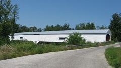
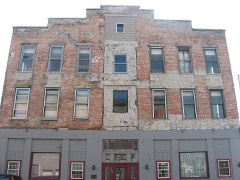
Listed on the National Register of Historic Places in 2000.
From the record
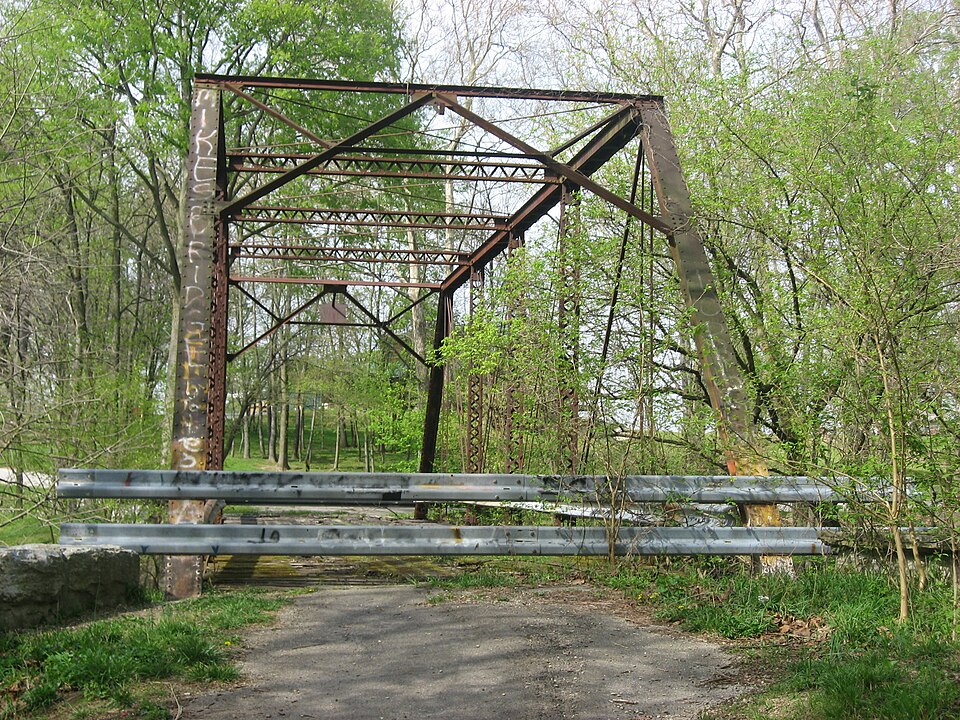
“Rush County Bridge No. 188 is a historic Pratt through Truss bridge located in Anderson Township, Rush County, Indiana. It was built in 1901 by the New Castle Bridge Company and spans the Little Flatrock River.”
Wikipedia article Rush County Bridge No. 188, CC BY-SA 4.0.
One of 28 National Register listings published here for Rush County · listed in 2000 · category: Structure.
National Register reference number.00001542- the number the National Park Service assigned this property when it was listed, and the key its nomination file is catalogued under at the National Archives.
James A. Barton, a native of Bourbon County, Ky., was born April 12, 1823, son of William and Ehzabeth (Summers) Barton, and is of English descent. The father of our subject was born in 1800 and died September 13, 1830. His mother was born in 1795 and lived to a good age. The Barton family came to Rush County in 1847, and our subject settled near Milroy, where he remained until 1856, when he removed to his parents' place of residence. Our subject began farming in early life and now owns 138 acres of well improved land in the western part of Anderson Township. Mr. Barton was married in 1851, to Miss Lucinda Amos, who was born in this count}^ August 8, 1832, and died here August 23, 1874. '^o ^^^ above marriage are these children, viz.: William L., born December 9, 1853; Lura, born July 29, 1S55, and Ella I., born July 28, 1857. Politically, Mr. Barton is a Republican, and has been a resident of Anderson Township for more ihan forty years and is an honored and respected citizen. His son William L., was made a Mason in 1875, ^^^ i^ now W. M., of Milroy Lodge No. 139, F. & A. M. The family is extensively known and respected.
William A. Blair, Trustee of Anderson Township, was born in Adams County, Ohio, April iSth, 1832, being the eldest in a family of twelve children, born to William L., and Catharine E. (Steen) Blair, the former a native of Middle Tennessee, born in 1803, and died in 1870; the latter born in Ohio in 1811, and died in 1877. They were members of the Presb3^terian Church and were true Christian people. Our subject received a limited education and remained under the parental roof until twentj-'-three years of age, working at the carpenter trade in connection with farming. In August, 1S62, he enlisted in Company E, Ninety-first Regiment, Ohio Volunteer Infantrj-, and was in active service until the following winter, when his health failed and he was sent to the hospital at Gallipohs, where he remained five months. He was honorably discharged in October, 1S63, and the same j-ear located in Delaware County, Ind., where he engaged in the undertaking business and later, worked in the school furniture factory at Richmond, Ind. In June, 18S3, he came to Milroy, where he engaged in the hardware business, and has won the respect and confidence of all who know him. Mr. Blair is an ardent Republican, and in 1886, was elected Township Trustee by that part}-. The marriage of Mr. Blair was solemnized April 12th, 1854, to Miss Mary E. Bloom, a native of Adams Countv, Ind., and daughter of John and Jane Bloom, natives of Ohio. Mrs. Blair died in 1855, and our subject was again married. Miss Sarah M. Freeman being the bride. Mrs. Blair was a native of Adams Count}-, Ohio, born in 1823, and died in 1878, leaving- three daughters, viz.: Dora E., Austa E. and Ora Maud. Mr. Blair married his present wife January 27th, 1879, she being Miss Jennie McKee, a native of Adams County, Ohio, born November 15th, 1857- To this union three children were born, viz. : Edith B., Ethel C. and Frank P. Mr. and Mrs. Blair are members of the United Presbyterian Church. He is a member of the G. A. R. Post, No. 456.
Regional context, not property-specific
evidence. The federal mineral resources record lists
2 workings within 5 miles of Rush County Bridge No. 188: 2 producers.
All of them still produce. What was taken out: Stone, Crushed/Broken, Limestone, Dimension. Distance is straight-line from the
map coordinates, so a quarry counted here may appear on a neighbouring
settlement's page as well.
Regional context, not property-specific
evidence. The National Weather Service names
Milroy, the town this property stands in, in 10 storm reports between 1995 and 2023: 8 thunderstorm wind, 2 hail.
No death or injury is recorded in these reports. Each account below is quoted exactly as the forecast office
filed it, from the NOAA Storm Events Database, and each date
opens the federal record of that event.
Several trees and utility lines were down around County Road 600 South and State Road 3 in Southern Rush County due to damaging thunderstorm wind gusts. This report was relayed by the county emergency manager.
No historic map-sheet match is published
for this property yet. That does not mean no map exists. This record needs
a coordinate-quality review before it can be joined to a sheet boundary.
Browse the county's mapped places while that work is
pending.
Listed places nearby
6 within 8 miles
Other National Register properties close
enough to walk or drive between, ordered by distance from this one. Both
positions come from the same geocoding pass that matched these properties
to their map sheets.
Listing record. National Park Service National Register of Historic Places, listed-properties dataset, current to 2026-05-22.
Map join. Address geocoded through the United States Census geocoder, then tested against the published boundary of every sheet in the USGS Historical Topographic Map Collection.
How this page is made. Listing fields come from federal records; map-sheet coverage is a labelled coordinate-to-boundary calculation, not a source-field claim.
Mines and quarries. USGS Mineral Resources Data System (MRDS) https://mrdata.usgs.gov/mrds/ A work of the United States government, no copyright under 17 U.S.C. 105.
Storms. NOAA National Centers for Environmental Information, Storm Events Database https://www.ncei.noaa.gov/stormevents/ A work of the United States government, no copyright under 17 U.S.C. 105. Narratives are quoted verbatim from the National Weather Service report and are not edited or summarised.
 Block