BlockBefore
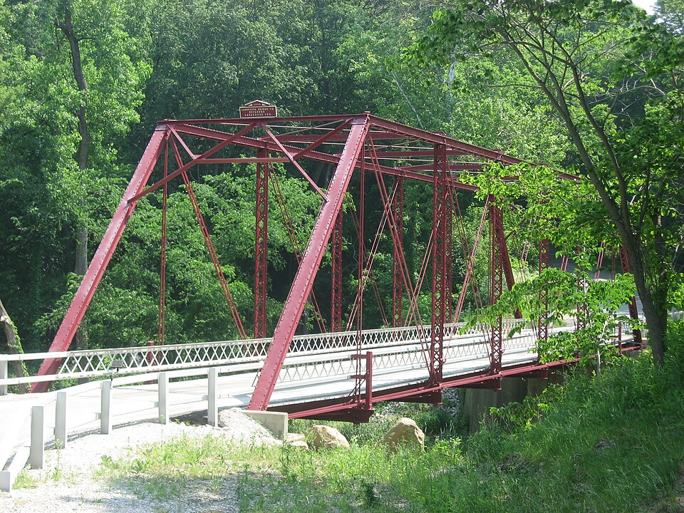
Photograph of Wilson Bridge
Photograph by Nyttend, Public domain. Via Wikimedia Commons.

Wilson Bridge

Listed on the National Register of Historic Places in 2001.

From the record

“Wilson Bridge, also known as Old Royster Ford and Carroll County Bridge No. 121, is a historic Pratt through truss bridge that spans Deer Creek and is located in Deer Creek Township, Carroll County, Indiana. It was built by the Lafayette Bridge Company in 1897-1898.”

Wikipedia article Wilson Bridge (Delphi, Indiana), CC BY-SA 4.0.

One of 37 National Register listings published here for Carroll County · listed in 2001 · category: Structure.

Sources: the Wikipedia article · the case file at the National Archives · the National Register database, National Park Service · the Wikipedia article
The listing

  • What is counted as historic. The nomination lists 1 structure as contributing to the listing.
  • Address. 0.6 mi. W of Cty Rd. 450W on Cty Rd. 300N over Deer Creek, Delphi, 46923
  • When was it listed? June 2001
  • Category. structure
  • Township. Deer Creek township
  • National Register reference number. 01000623 - the number the National Park Service assigned this property when it was listed, and the key its nomination file is catalogued under at the National Archives.

The ground it stands on

11,192 words

The chapter on Deer Creek Township in History of Carroll County, Indiana : With Illustrations and Biographical Sketches of Some of Its Prominent Men and Pioneers ..., published 1882 names Delphi. This is what it says, exactly as the scans read.

While Mr. Crawford was the Pastor of this church, he piu' chased a lot and built thereon a log house, one of the first dwellings erected in Delphi, which was then a general hazel thicket. This humble dwelling was torn down many years ago, and the site occupied by the more stately mansion of S. D. Mcintosh. For several years, the meetings of the congregation were held in the old log schoolhouse built by Deer Creek Township in the winter of 1828-29, which served the pm-pose of a meeting-place in its time for not only the religious organizations, but for all congi'egations, whether for secular or other piu'poses.

Passage source: History of Carroll County, Indiana : With Illustrations and Biographical Sketches of Some of Its Prominent Men and Pioneers ..., published 1882.

TN the latter part of July, 1829, a number of persons, members -*- of the Regular Baptist Chiu-ch in other jiu'isdietions, who, having become residents of CaiToll County and vicinity, had prociu-ed letters of recommendation to those of like faith in this jui'isdiction to the end that they might unite with such in the formation of a chiu-ch here, and thus eujoy the privileges of public worship in their own neighborhood, made application to the proper authority for consent to foim a chiu'ch in this county, requesting the necessaiy attendance of church officers and delegates for the purpose. The consent was obtained accordingly, and ou the 8th of August following a council of delegates was held, composed of the representatives named, to wit: Jacob Kester, A. B. Martin and James Duncan, from Sugar Creek Chiu'ch. in Boone County; Elder R. Stapleton, David Kuth and Michael Donahoe, from Bethel Chiu'ch; and J. F. Martin, Newbeny Stockton and Elder Samuel Ai-thiu-, from the First Baptist Chiu'ch in Wea, Tippecanoe County. The council was organized by electing Elder Stapleton, Moderator, and A. B. Martin. Clerk. The covenant of faith which had been signed by the applicants Ijeing read, with their letters of recommendation, in open council, the following persons, with their foimer affiliation - John Knight. Abigail Knight. Elsa Green. Hannah Green and Sarah Hance, from the Baptist Church of Staunton. Ohio; William Hance and Isabel Cox, from Lick Creek Chm-ch, Marion County. Ohio, were accepted, and, in compliance with their re quest, constituted a Regular Baptist Chiu'ch in Delphi.

Passage source: History of Carroll County, Indiana : With Illustrations and Biographical Sketches of Some of Its Prominent Men and Pioneers ..., published 1882.

Machine-read from a century-old scan, so expect the errors a machine makes: misspelled names, dropped words, stray characters.

Read the whole chapter on Deer Creek Township - 11,192 words on its settlement, mills, schools and churches.

Fires near this property

4 since 2007

Regional context, not property-specific evidence. The federal wildfire occurrence database lists 4 fires within 5 miles of Wilson Bridge between 2007 and 2008, burning about 1 acre in total. None started naturally. None was recorded as arson. Distance is straight-line from the map coordinates, so a fire counted here may appear on a neighbouring settlement's page as well.

Reported cause Fires
Missing data/not specified/undetermined3
Debris and open burning1

The most recent of them, most recent first, with the day each was reported and the service that recorded it.

DateCause SizeReported by Name on the report
13 September 2007Missing data/not specified/undeterminedunder an acreIndiana State Fire Marshal's Officenot named
8 August 2007Debris and open burningunder an acreIndiana State Fire Marshal's Officenot named
22 May 2007Missing data/not specified/undeterminedunder an acreIndiana State Fire Marshal's Officenot named
5 February 2008Missing data/not specified/undeterminedunder an acreIndiana State Fire Marshal's Officenot named

Every fire recorded in Carroll County

Mines and quarries near this property

5 within 5 miles

Regional context, not property-specific evidence. The federal mineral resources record lists 5 workings within 5 miles of Wilson Bridge: 3 producers, 1 past producer, 1 occurrence. 3 still produce. What was taken out: Sand and Gravel, Construction, Stone, Crushed/Broken, Lead, Zinc, Sulfur. Distance is straight-line from the map coordinates, so a quarry counted here may appear on a neighbouring settlement's page as well.

Where SiteCommodity StatusRecorded
Delphi Limestone QuarryStone, Crushed/BrokenProducer
Sphalerite Occurrence Z55Lead, Zinc, SulfurOccurrenceSphalerite
Munson PitSand and Gravel, ConstructionProducer
Vianco PitSand and Gravel, ConstructionPast Producer
Wallace PitSand and Gravel, ConstructionProducer

Every working recorded in Carroll County

Storms near this property

42 since 1994

Regional context, not property-specific evidence. The National Weather Service names Delphi, the town this property stands in, in 42 storm reports between 1994 and 2025: 26 thunderstorm wind, 10 hail, 4 flash flood, 1 lightning. No death or injury is recorded in these reports. Each account below is quoted exactly as the forecast office filed it, from the NOAA Storm Events Database, and each date opens the federal record of that event.

WhenEvent Place namedHarm What the report says
April 2020Thunderstorm WindDelphi$50,000Emergency manager reports numerous power lines were knocked down due to thunderstorm wind gusts. Trees and tree limbs of unknown size were also snapped.
June 1996LightningDelphi$30,000no account filed
March 2025Thunderstorm WindDelphi$25,000A few structures sustained minor damage caused by thunderstorm winds across the county with a centralized location near Delphi.
March 2025Thunderstorm WindDelphi$20,000Dozens of trees downed by thunderstorm wind gusts near Delphi and points to the northeast.
July 2011Flash FloodNorth Delphi$20,000Several culverts were washed out on County Roads between Delphi and the Tippecanoe River due to over 5 inches of thunderstorm rainfall.
June 2011Thunderstorm WindDelphi$9,000Numerous power lines and trees were downed on roadways due to damaging thunderstorm wind gusts.
July 2012Thunderstorm WindDelphi$5,000Trees were downed in Delphi due to damaging thunderstorm wind gusts.
July 2011Thunderstorm WindNorth Delphi$5,000Trees were downed in this location due to damaging thunderstorm wind gusts.
June 2010Thunderstorm WindDelphi$5,000Trees were reported down in Delphi due to damaging thunderstorm wind gusts.
August 2014Thunderstorm WindDelphi$3,000A tree fell on top of a shop building due to damaging thunderstorm wind gusts.
May 2010Thunderstorm WindDelphi$3,000Numerous trees of unknown size were reported down in Delphi.
August 2020Thunderstorm WindNorth Delphi$2,000Trees of unknown size downed due to thunderstorm wind gusts across Old Indiana 25 going into Delphi at the Carroll and Tippecanoe county border going down the hill.
June 2015Thunderstorm WindNorth Delphi$1,000A tree was blown down on the west side of Delphi, blocking Bicycle Bridge Road, due to damaging thunderstorm wind gusts.
August 2014FloodDelphi$500Four to five inches of water was over the road due to heavy thunderstorm rainfall. Wind gusts of 45 mph were also observed.
May 2010HailDelphi-Nickel sized hail was reported at the intersection of Highway 450 W and 375 N.
August 2007Thunderstorm WindDelphi-Trees were down on Franklin Street in Delphi due to damaging thunderstorm winds.
May 2007HailDelphi-Hail lasted three minutes at State Road 29 and 900 North.
April 2006HailDelphi-No damage estimates were available.
April 2006Flash FloodDelphi-Roads were flooded in Delphi. No property damage was reported.
April 2006HailDelphi-No property damage estimates were available.
August 2006Thunderstorm WindDelphi-Nine trees were downed.
May 2005Thunderstorm WindDelphi-Trees were blown down near Delphi.
September 2005Thunderstorm WindDelphi-A large tree was downed.
July 2003Thunderstorm WindDelphi-Trees and power lines down
June 2013HailDelphi-no account filed
May 2007HailDelphi-no account filed
June 2006Thunderstorm WindDelphi-no account filed
May 2004Thunderstorm WindDelphi-no account filed
July 2003Flash FloodDelphi-no account filed
July 2003Thunderstorm WindDelphi-no account filed
May 2001Thunderstorm WindDelphi-no account filed
June 2001Thunderstorm WindDelphi-no account filed
August 2001Thunderstorm WindDelphi-no account filed
October 2001Thunderstorm WindDelphi-no account filed
April 2000HailDelphi-no account filed
June 2000Thunderstorm WindDelphi-no account filed
June 1996Flash FloodDelphi-no account filed
July 1996Thunderstorm WindDelphi-no account filed
July 1994HailDelphi-no account filed

Every storm recorded in Carroll County

Map coverage status

No historic map-sheet match is published for this property yet. That does not mean no map exists. This record needs a coordinate-quality review before it can be joined to a sheet boundary. Browse the county's mapped places while that work is pending.

Listed places nearby

6 within 8 miles

Other National Register properties close enough to walk or drive between, ordered by distance from this one. Both positions come from the same geocoding pass that matched these properties to their map sheets.

Photograph PropertyDistance Listed
Deer Creek Valley Rural Historic District0.6 miles2002
Fred and Minnie Raber Farm1.4 miles1992
Baum-Shaeffer Farm2.0 miles1998
Carroll County Infirmary2.4 miles2018
Foreman-Case House2.6 miles1990
North Street Viaduct2.7 miles2023

Sources for this property

National Archives recordThe nomination case file for reference 01000623 in Record Group 79.
Wikipedia articleCommunity-written account of this property, licensed CC BY-SA.
Carroll CountyAll 37 listed properties in this county.

Provenance

  • Listing record. National Park Service National Register of Historic Places, listed-properties dataset, current to 2026-05-22.
  • Map join. Address geocoded through the United States Census geocoder, then tested against the published boundary of every sheet in the USGS Historical Topographic Map Collection.
  • How this page is made. Listing fields come from federal records; map-sheet coverage is a labelled coordinate-to-boundary calculation, not a source-field claim.
  • Wildfire. Short, Karen C. 2022. Spatial wildfire occurrence data for the United States, 1992-2020 [FPA_FOD_20221014]. 6th Edition. Fort Collins, CO: Forest Service Research Data Archive. https://doi.org/10.2737/RDS-2013-0009.6 Collected with United States Government funding and usable without additional permissions or fees.
  • Mines and quarries. USGS Mineral Resources Data System (MRDS) https://mrdata.usgs.gov/mrds/ A work of the United States government, no copyright under 17 U.S.C. 105.
  • Storms. NOAA National Centers for Environmental Information, Storm Events Database https://www.ncei.noaa.gov/stormevents/ A work of the United States government, no copyright under 17 U.S.C. 105. Narratives are quoted verbatim from the National Weather Service report and are not edited or summarised.