BlockBefore
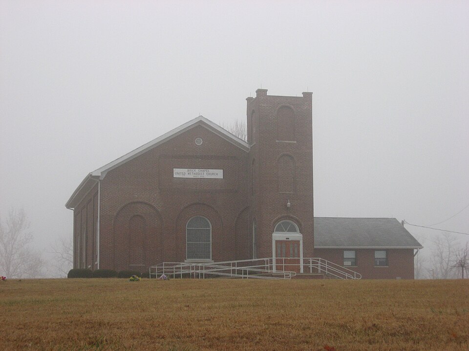
Photograph of Brick Chapel United Methodist Church
Photograph by Nyttend, Public domain. Via Wikimedia Commons.

Brick Chapel United Methodist Church

Listed on the National Register of Historic Places in 2003.

From the record

“Brick Chapel United Methodist Church, also known as Montgomery Chapel, is a historic Methodist church located in Monroe Township, Putnam County, Indiana. The church was built in 1872, and extensively remodeled in 1912 in the Renaissance Revival style.”

Wikipedia article Brick Chapel United Methodist Church, CC BY-SA 4.0.

One of 33 National Register listings published here for Putnam County · listed in 2003 · category: Building.

Sources: the Wikipedia article · the case file at the National Archives · the National Register database, National Park Service

The listing

  • What is counted as historic. The nomination lists 1 building, 1 site as contributing to the listing.
  • Address. 3547 N US 231, Greencastle, 46135
  • When was it listed? September 2003
  • Category. building
  • Township. Monroe township
  • National Register reference number. 03000973 - the number the National Park Service assigned this property when it was listed, and the key its nomination file is catalogued under at the National Archives.

The ground it stands on

741 words

The chapter on Monroe Township in Biographical and Historical Record of Putnam County, Indiana .., published 1887 names Greencastle. This is what it says, exactly as the scans read.

This township was one of/ the first settled, and is one of the best in the county. It is Congressional township 15, range 4, and is bounded on the north by Franklin, on the east by Floyd, on the south by Greencastle, . and on the west by Clinton townships. The surface is mostly level in the north part, but more rolling in the south. The soil is a rich black loam, superimposed upon a yellow clay subsoil. Like the rest of the county, Monroe was originally covered with a splendid growth of valuable timber, most of which has been cut and sold. The streams of the township consist of a few branches of Big and Little Walnnt, the latter just cutting the southeast corner on section 38. ' The township is well improved. It has two gravel roads, one running north from Greeueastle, the other west from Bainbridge. Along these roads lies some of the finest country in Putnam Count)'; and the farms are well improved, presenting the evidence of care and skill on the part of their owner*.

Passage source: Biographical and Historical Record of Putnam County, Indiana .., published 1887.

Machine-read from a century-old scan, so expect the errors a machine makes: misspelled names, dropped words, stray characters.

Read the whole chapter on Monroe Township - 741 words on its settlement, mills, schools and churches.

Mines and quarries near this property

4 within 5 miles

Regional context, not property-specific evidence. The federal mineral resources record lists 4 workings within 5 miles of Brick Chapel United Methodist Church: 3 producers, 1 past producer. 3 still produce. What was taken out: Stone, Crushed/Broken, Stone, Sand and Gravel, Construction. Distance is straight-line from the map coordinates, so a quarry counted here may appear on a neighbouring settlement's page as well.

Where SiteCommodity StatusRecorded
Bainbridge Sand and Gravel PitSand and Gravel, ConstructionPast Producer
Putnam Co. Hwy. Dept.StoneProducer
Harris Stone Service IncStone, Crushed/BrokenProducer
Lone Star Greencastle QuarryStone, Crushed/BrokenProducer

Every working recorded in Putnam County

Storms near this property

60 of 75 shown

Regional context, not property-specific evidence. The National Weather Service names Greencastle, the town this property stands in, in 75 storm reports between 1993 and 2020: 40 thunderstorm wind, 29 hail, 3 flash flood, 1 tornado. No death or injury is recorded in these reports. Each account below is quoted exactly as the forecast office filed it, from the NOAA Storm Events Database, and each date opens the federal record of that event.

WhenEvent Place namedHarm What the report says
August 2002Tornado (F1)Greencastle$200,000A tornado briefly touched down at the Putnam County Fairground and destroyed 1 horse stable and damaged one other building.
July 2008Thunderstorm WindGreencastle$70,000The area along Washington Street and Bloomington Street saw a lot of tree and utility line damage from thunderstorm winds. Witnesses at the Putnam County Fairgrounds said several chickens were killed as a result of the storm.
May 1996Thunderstorm WindGreencastle$70,000no account filed
April 1993Thunderstorm WindGreencastle$50,000Trees were downed 5 miles northwest of Greencastle, and there was some minor damage to homes in the area. South of Fincastle a roof was blown of a barn.
March 1996Thunderstorm WindGreencastle$50,000no account filed
January 2008Thunderstorm WindGreencastle$45,000A utility pole, a garage, a horse barn, and a camper were damaged in Greencastle due to damaging thunderstorm winds.
January 2008Thunderstorm WindGreencastle$28,000Part of the roof on a pole barn and a modular home was blown off due to damaging thunderstorm winds. Windows were blown in at a business. A tree fell due to the thunderstorm winds and crushed a truck.
August 2000Thunderstorm WindGreencastle$20,000no account filed
August 2019Thunderstorm WindGreencastle$10,000Emergency manager reports multiple trees and tree limbs downed due to thunderstorm wind gusts with some on having fallen on cars.
July 2004Thunderstorm WindGreencastle$10,000A tree fell onto a house.
July 2020Thunderstorm WindGreencastle$5,000Numerous trees downed due to thunderstorm wind gusts between Greencastle and Fillmore. 0.5 inch hail also occurred at the same time.
July 2015Flash FloodGreencastle$5,000Water, estimated at 8 to 10 inches deep, was covering the road at the intersection of Highfall and Shadowlawn Avenues. No barricades were in place but police were aware of the flooding. Multiple other locations inside and outside the city limits also have flooding.
June 2008Flash FloodGreencastle$5,000Roadways were covered and previous flooding conditions were exacerbated due to heavy rainfall that caused flash flooding.
December 1998Thunderstorm WindGreencastle$5,000no account filed
July 2012Thunderstorm WindGreencastle$3,000Several trees were reported down in Madison Township due to damaging thunderstorm wind gusts.
July 2008Thunderstorm WindGreencastle$2,500Power lines were down in the vicinity of United States Highway 231 South. No further details of location were given.
July 2020Thunderstorm WindGreencastle$2,000Power lines and poles were downed due to thunderstorm wind gusts across town. A 50 mph wind gust was measured around the same time.
August 2014FloodGreencastle$1,000Several streets in Greencastle were water covered due to heavy thunderstorm rainfall.
June 2010LightningGreencastle$1,000Lightning struck a barn northwest of Greencastle near the intersection of County Road 300 W and 25 N. Damage to the barn was reportedly minor. The owner fought the fire and put it out using a garden hose. The time this event occurred was estimated.
February 2008Thunderstorm WindGreencastle$1,000Trees and power lines were reported down due to damaging thunderstorm winds.
April 2006Thunderstorm WindGreencastle$1,000Power lines were downed.
April 2006Thunderstorm WindGreencastle$1,000Power lines and trees were downed.
March 1996Thunderstorm WindGreencastle$1,000no account filed
June 2008HailGreencastle-In addition to the hail wind gusts to 30 mph also occurred.
June 2008Thunderstorm WindGreencastle-Four healthy trees broke off at ground level and fell across the road.
July 2008Thunderstorm WindGreencastle-Trees and/or tree limbs were blown down by thunderstorm winds in town.
January 2008Thunderstorm WindGreencastle-Gust was measured with wind equipment mounted on a truck. Numerous trees were also reported down around the city due to damaging thunderstorm winds.
June 2007Thunderstorm WindGreencastle-Trees were reported down along state road 231 just north of 200 N.
June 2006HailGreencastle-No property damage reported.
June 2006Thunderstorm WindGreencastle-Trees were downed.
May 2005Thunderstorm WindGreencastle-Several trees were downed in Greencastle.
May 2005Thunderstorm WindGreencastle-A few trees were downed.
July 2005Thunderstorm WindGreencastle-Trees were blown down.
November 2005Thunderstorm WindGreencastle-A few trees were downed.
July 2003Thunderstorm WindGreencastle-Several trees and power outages
March 2012HailGreencastle-no account filed
February 2011HailGreencastle-no account filed
October 2007HailGreencastle-no account filed
April 2007HailGreencastle-no account filed
March 2006HailGreencastle-no account filed
April 2006HailGreencastle-no account filed
March 2006HailGreencastle-no account filed
May 2006HailGreencastle-no account filed
June 2006HailGreencastle-no account filed
May 2005HailGreencastle-no account filed
June 2005HailGreencastle-no account filed
May 2004Thunderstorm WindGreencastle-no account filed
July 2004Thunderstorm WindGreencastle-no account filed
June 2004HailGreencastle-no account filed
May 2003HailGreencastle-no account filed
July 2003Flash FloodGreencastle-no account filed
July 2003Thunderstorm WindGreencastle-no account filed

Every storm recorded in Putnam County

Map coverage status

No historic map-sheet match is published for this property yet. That does not mean no map exists. This record needs a coordinate-quality review before it can be joined to a sheet boundary. Browse the county's mapped places while that work is pending.

Listed places nearby

6 within 8 miles

Other National Register properties close enough to walk or drive between, ordered by distance from this one. Both positions come from the same geocoding pass that matched these properties to their map sheets.

Photograph PropertyDistance Listed
James Edington Montgomery O'Hair House1.0 miles1992
Dunbar Covered Bridge3.8 miles2024
Northwood Historic District4.5 miles2011
Old Greencastle Historic District4.6 miles2011
Alfred Hirt House4.6 miles1991
McKim Observatory, DePauw University4.7 miles1978

Sources for this property

National Archives recordThe nomination case file for reference 03000973 in Record Group 79.
Wikipedia articleCommunity-written account of this property, licensed CC BY-SA.
Putnam CountyAll 33 listed properties in this county.

Provenance

  • Listing record. National Park Service National Register of Historic Places, listed-properties dataset, current to 2026-05-22.
  • Map join. Address geocoded through the United States Census geocoder, then tested against the published boundary of every sheet in the USGS Historical Topographic Map Collection.
  • How this page is made. Listing fields come from federal records; map-sheet coverage is a labelled coordinate-to-boundary calculation, not a source-field claim.
  • Mines and quarries. USGS Mineral Resources Data System (MRDS) https://mrdata.usgs.gov/mrds/ A work of the United States government, no copyright under 17 U.S.C. 105.
  • Storms. NOAA National Centers for Environmental Information, Storm Events Database https://www.ncei.noaa.gov/stormevents/ A work of the United States government, no copyright under 17 U.S.C. 105. Narratives are quoted verbatim from the National Weather Service report and are not edited or summarised.