BlockBefore
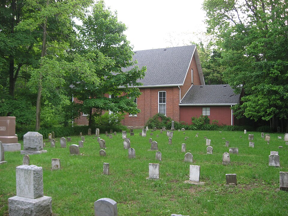
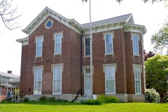
Photograph of Richsquare Friends Meetinghouse and Cemetery
Photograph by Nyttend, Public domain. Via Wikimedia Commons.

Richsquare Friends Meetinghouse and Cemetery

Listed on the National Register of Historic Places in 2006.

From the record

“Richsquare Friends Meetinghouse and Cemetery is an historic Quaker meeting house and cemetery located in Franklin Township, Henry County, Indiana. The meeting house was built in 1895, and is a one-story, brick building with a two-story Romanesque Revival style corner tower.”

Wikipedia article Richsquare Friends Meetinghouse and Cemetery, CC BY-SA 4.0.

One of 13 National Register listings published here for Henry County · listed in 2006 · category: Building.

Sources: the Wikipedia article · the case file at the National Archives · the National Register database, National Park Service
The listing

  • What is counted as historic. The nomination lists 1 building, 1 site as contributing to the listing.
  • Address. 5685 S Cty Rd. East, Lewisville, 47387
  • When was it listed? April 2006
  • Category. building
  • Township. Franklin township
  • National Register reference number. 06000305 - the number the National Park Service assigned this property when it was listed, and the key its nomination file is catalogued under at the National Archives.

The ground it stands on

11,338 words

The chapter on Franklin Township in History of Henry County, Indiana : Together with Sketches of Its Cities, Villages, and Towns ... Also a Condensed History of Indiana, Embracing Accounts of Pre-historic Races, Aborigines, Winnebago and Black Hawk Wars, and a Brief Review of Its Civil and Political History., published 1884 names Lewisville. This is what it says, exactly as the scans read.

Franklin Township was formed by the county commissioners, Jan. 5, 1830, from fractions of Dudley and Wayne. It then included nearly all of its present territory, all of Spiceland, and a small portion both of Wayne and Greensboro. In 1831 the western boundary was changed, giving a tier of sections from Franklin to Wayne. In 1838 a small portion was added to Greensboro and the land is generally fertile and the farms and improvements excellent. The enterprising town of Lewisville is the only village in the township. The Chicago, St. Louis & Pittsburg Eailroad crosses the southern part of the township from east to west.

Passage source: History of Henry County, Indiana : Together with Sketches of Its Cities, Villages, and Towns ... Also a Condensed History of Indiana, Embracing Accounts of Pre-historic Races, Aborigines, Winnebago and Black Hawk Wars, and a Brief Review of Its Civil and Political History., published 1884.

Along Flatrock Creek the first settlements in the township were made as early as 1822 - probably some came the year before. Achilles Morris, George See, Charles See and Moses Keen were among the first to begin improvements. Other early settlers up to 1833 were: Joseph Paul, Isaiah Hosier, Christopher Hedrick, Stanton Butler, John, James and Patton Ball, Daniel Johnson, Wm. and Robert Smith, Joseph Van Buskirk, James Butler, Isaac Parker, Wm. C. Goar, Matthew and Joseph Farley, Joseph White, Herman Herr, David Hedrick, Mark Wilson, John and Enos Heacock, Wm. Brown, Cyrus Coffin, T. W. Smith, Mahlon Pickering, John Russell, Martin Vickery, Philo Southwick and others. Moman Ballard, from West Virginia, came to Dudley Township in 1830, and to his present farm in Franklin in 1833. Joseph Fletcher, still living, came to the vicinity of Lewisville in 1822. Garnet Hayden was another early settler in the southern part of the township.

Passage source: History of Henry County, Indiana : Together with Sketches of Its Cities, Villages, and Towns ... Also a Condensed History of Indiana, Embracing Accounts of Pre-historic Races, Aborigines, Winnebago and Black Hawk Wars, and a Brief Review of Its Civil and Political History., published 1884.

Machine-read from a century-old scan, so expect the errors a machine makes: misspelled names, dropped words, stray characters.

Read the whole chapter on Franklin Township - 11,338 words on its settlement, mills, schools and churches.

Storms near this property

4 since 1995

Regional context, not property-specific evidence. The National Weather Service names Lewisville, the town this property stands in, in 4 storm reports between 1995 and 2018: 3 thunderstorm wind, 1 hail. No death or injury is recorded in these reports. Each account below is quoted exactly as the forecast office filed it, from the NOAA Storm Events Database, and each date opens the federal record of that event.

WhenEvent Place namedHarm What the report says
May 1999Thunderstorm WindLewisville$5,000no account filed
May 2018Thunderstorm WindLewisville$1,000A dead tree, of unknown size, was blown across State Road 103 due to strong thunderstorm wind gusts.
May 1995Thunderstorm WindLewisville-A 90-foot tower collapsed.
May 2005HailLewisville-no account filed

Every storm recorded in Henry County

Map coverage status

No historic map-sheet match is published for this property yet. That does not mean no map exists. This record needs a coordinate-quality review before it can be joined to a sheet boundary. Browse the county's mapped places while that work is pending.

Listed places nearby

5 within 8 miles

Other National Register properties close enough to walk or drive between, ordered by distance from this one. Both positions come from the same geocoding pass that matched these properties to their map sheets.

Photograph PropertyDistance Listed
Guyer Opera House3.2 miles1979
Gen. William Grose House5.3 miles1983
Henry County Courthouse5.6 miles1981
New Castle Commercial Historic District5.6 miles1991
Henry County Memorial Park7.1 miles2020

Sources for this property

National Archives recordThe nomination case file for reference 06000305 in Record Group 79.
Wikipedia articleCommunity-written account of this property, licensed CC BY-SA.
Henry CountyAll 13 listed properties in this county.

Provenance

  • Listing record. National Park Service National Register of Historic Places, listed-properties dataset, current to 2026-05-22.
  • Map join. Address geocoded through the United States Census geocoder, then tested against the published boundary of every sheet in the USGS Historical Topographic Map Collection.
  • How this page is made. Listing fields come from federal records; map-sheet coverage is a labelled coordinate-to-boundary calculation, not a source-field claim.
  • Storms. NOAA National Centers for Environmental Information, Storm Events Database https://www.ncei.noaa.gov/stormevents/ A work of the United States government, no copyright under 17 U.S.C. 105. Narratives are quoted verbatim from the National Weather Service report and are not edited or summarised.