BlockBefore
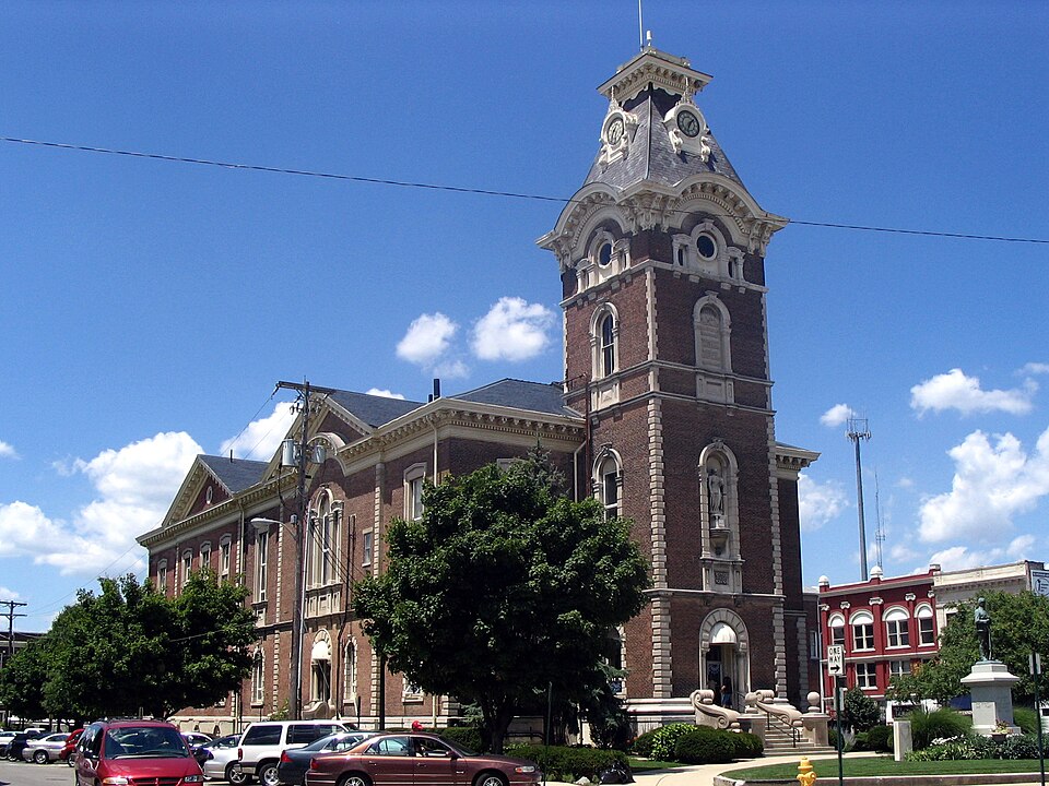
Photograph of Henry County Courthouse
Photograph by Publichall, CC BY-SA 3.0. Via Wikimedia Commons.

Henry County Courthouse

Listed on the National Register of Historic Places in 1981.

From the record

“The Henry County Courthouse is a historic courthouse located in New Castle, Indiana, US, on the land designated as court house square by the Henry County Commissioners. The Court House was built between 1865 and 1869 at a cost of $120,000.”

Wikipedia article Henry County Courthouse (Indiana), CC BY-SA 4.0.

One of 13 National Register listings published here for Henry County · listed in 1981 · category: Building.

Sources: the Wikipedia article · the case file at the National Archives · the National Register database, National Park Service
The listing

  • What is counted as historic. The nomination lists 1 building as contributing to the listing.
  • Address. Courthouse Sq., New Castle, 47362
  • When was it listed? April 1981
  • Category. building
  • Township. Henry township
  • Architectural style. Second Empire architecture in the United States and Canada, Italianate architecture, Renaissance Revival architecture
  • Architect. Isaac Hodgson
  • National Register reference number. 81000013 - the number the National Park Service assigned this property when it was listed, and the key its nomination file is catalogued under at the National Archives.

The ground it stands on

774 words

This property stands in Henry Township. Henry County; Past and Present: a Brief History of the County from 1821 to 1871, published 1871 gives that township a chapter of its own.

The chapter covers the township.

Machine-read from a century-old scan, so expect the errors a machine makes: misspelled names, dropped words, stray characters.

Read the whole chapter on Henry Township - 774 words on its settlement, mills, schools and churches.

Mines and quarries near this property

2 within 5 miles

Regional context, not property-specific evidence. The federal mineral resources record lists 2 workings within 5 miles of Henry County Courthouse: 2 past producers. None of them still produces. What was taken out: Sand and Gravel, Construction. Distance is straight-line from the map coordinates, so a quarry counted here may appear on a neighbouring settlement's page as well.

Where SiteCommodity StatusRecorded
Mt. Summit PitSand and Gravel, ConstructionPast Producer
New Castle PitSand and Gravel, ConstructionPast Producer

Every working recorded in Henry County

Storms near this property

60 of 79 shown

Regional context, not property-specific evidence. The National Weather Service names New Castle, the town this property stands in, in 79 storm reports between 1993 and 2025: 38 thunderstorm wind, 28 hail, 5 tornado, 4 flash flood. The reports record 1 injury. Each account below is quoted exactly as the forecast office filed it, from the NOAA Storm Events Database, and each date opens the federal record of that event.

WhenEvent Place namedHarm What the report says
September 2003Thunderstorm WindNew Castle1 hurt, $200,000no account filed
September 2002Tornado (F2)New Castle$2,000,000A tornado formed along a squall line. Ten single family homes sustained major damage. As the tornado passed through a trailer park, 30 trailer homes sustained major damage.
July 2004LightningNew Castle$500,000A bus barn was destroyed by a lightning induced fire at Blue River Valley High School.
June 2008Flash FloodNew Castle$50,000Flash flooding occurred around the county causing damage to property and roadways.
April 1994Thunderstorm WindNew Castle$50,000A thunderstorm blew a tree down onto a house, barn, and garage in Knightstown. A large commercial-use garage was demolished by straight line winds.
April 2020Thunderstorm WindNew Castle$40,000Barn with metal siding was blown down at this location due to thunderstorm wind gusts. Nearby, several trees and power lines we downed.
July 2002Tornado (F0)New Castle$30,000National Weather Service survey confirmed an F0 touchdown. Minor damage to 3 homes. Trees down.
June 2012Thunderstorm WindNew Castle$20,000The roof of a building near the intersection of 9th and New York Streets was blown down due to damaging thunderstorm wind gusts.
July 1995Thunderstorm WindNew Castle$20,000Trees and power lines were downed. The top of a 140-foot radio tower was blown down in New Castle.
September 2005Tornado (F0)New Castle$15,000What was likely a small gustnado swept quickly through a field and a small subdivision of manufactured homes, causing minor damage to crops, two roofs, and outdoor decorations.
July 2024Thunderstorm WindNew Castle$10,000Thunderstorm winds downed several trees in the New Castle area, before a funnel cloud was observed just above the ground 1 mile east of New Castle.
July 2010FloodNew Castle$10,000Minor flooding was reported in the New Castle area. The Henry County Emergency Management spokesperson said that Crescent Creek Drive was the only road closed due to flooding. He also reported floodwater that blew out the basement windows of one home. Some parks also had standing water.
May 2008LightningNew Castle$10,000Lightning struck the wall of a church catching the wall on fire.
May 2008Thunderstorm WindNew Castle$8,000Gravestones were moved off their bases and flower arrangement were scattered due to damaging thunderstorm winds. Twenty four trees also were blown down on the property due to the winds.
July 1994Thunderstorm WindNew Castle$5,000Trees and power lines were downed.
June 1998Tornado (F2)New Castle$5,000no account filed
September 2007Thunderstorm WindNew Castle$4,000A power pole was down, a tree was reported to be on a road, and a large produce tent was blown over in New Castle due to damaging thunderstorm winds. Several trees were reported to be down in other locations around the county as well.
May 2008Thunderstorm WindNew Castle$3,000Numerous trees and power lines were reported down at various points in the county.
April 2025Thunderstorm WindNew Castle$2,000Tree downed by thunderstorm wind gusts onto a road.
June 2021Thunderstorm WindNew Castle$2,000Tree downed by thunderstorm wind gusts near the intersection of State Road 103 and County Road 300 South.
September 2005Thunderstorm WindNew Castle$2,000Trees and power lines were downed.
August 2019Thunderstorm WindNew Castle$1,250A tree with an 18-inch base was downed due to damaging thunderstorm wind gusts.
July 2017HailNew Castle$1,000Thunderstorm wind gusts were estimated at 70 mph. Power was reported to be out with a fence blown down.
July 1997Thunderstorm WindNew Castle$1,000Thunderstorm winds blew down trees and damged some crops
July 1997Tornado (F0)New Castle$1,000Same supercell thunderstorm that spawned Hamilton County and City of Anderson tornadoes also spawned this weak tornado. It was a brief touchdown near State Road 3 and the Conrail Railway on New Castle's northwest side. The tornado briefly touched down in Memorial Park knocking down some trees.
August 2011Thunderstorm WindNew Castle$100An estimated thunderstorm wind gusts of 50 mph downed a 4-inch diameter tree limb.
June 2021Thunderstorm WindNew Castle-A storm spotter estimated a 60 mph thunderstorm wind gust at this location.
June 2018HailNew Castle-This report was received via Twitter.
August 2009HailNew Castle-Thunderstorm hail, the size of ping pong balls was observed at 15th Street and Grand Avenue in New Castle.
May 2006HailNew Castle-No property damage was reported.
May 2005Thunderstorm WindNew Castle-Trees were blown down.
June 2005Thunderstorm WindNew Castle-Large limbs were blown down.
June 2005Thunderstorm WindNew Castle-Trees and limbs were blown down.
August 2005Thunderstorm WindNew Castle-Trees were blown down and a barn was damaged.
July 2005Thunderstorm WindNew Castle-Numerous trees and power lines downed.
September 2005Thunderstorm WindNew Castle-A large healthy tree was downed.
November 2005Thunderstorm WindNew Castle-Trees were downed.
May 2003Thunderstorm WindNew Castle-Trees/Limbs down
July 1994Thunderstorm WindNew Castle-Large limbs were downed on the north side of New Castle.
May 1993Thunderstorm WindNew Castle-Trees were downed.
June 2021HailNew Castle-no account filed
May 2019HailNew Castle-no account filed
May 2011HailNew Castle-no account filed
June 2008Thunderstorm WindNew Castle-no account filed
April 2006HailNew Castle-no account filed
May 2006HailNew Castle-no account filed
June 2006HailNew Castle-no account filed
May 2006HailNew Castle-no account filed
May 2005HailNew Castle-no account filed
June 2005Thunderstorm WindNew Castle-no account filed
May 2003Flash FloodNew Castle-no account filed

Every storm recorded in Henry County

Map coverage status

No historic map-sheet match is published for this property yet. That does not mean no map exists. This record needs a coordinate-quality review before it can be joined to a sheet boundary. Browse the county's mapped places while that work is pending.

Listed places nearby

4 within 8 miles

Other National Register properties close enough to walk or drive between, ordered by distance from this one. Both positions come from the same geocoding pass that matched these properties to their map sheets.

Photograph PropertyDistance Listed
New Castle Commercial Historic Districtunder 500 feet1991
Gen. William Grose House0.4 miles1983
Henry County Memorial Park1.5 miles2020
Richsquare Friends Meetinghouse and Cemetery5.6 miles2006

Sources for this property

National Archives recordThe nomination case file for reference 81000013 in Record Group 79.
Wikipedia articleCommunity-written account of this property, licensed CC BY-SA.
Henry CountyAll 13 listed properties in this county.

Provenance

  • Listing record. National Park Service National Register of Historic Places, listed-properties dataset, current to 2026-05-22.
  • Map join. Address geocoded through the United States Census geocoder, then tested against the published boundary of every sheet in the USGS Historical Topographic Map Collection.
  • How this page is made. Listing fields come from federal records; map-sheet coverage is a labelled coordinate-to-boundary calculation, not a source-field claim.
  • Mines and quarries. USGS Mineral Resources Data System (MRDS) https://mrdata.usgs.gov/mrds/ A work of the United States government, no copyright under 17 U.S.C. 105.
  • Storms. NOAA National Centers for Environmental Information, Storm Events Database https://www.ncei.noaa.gov/stormevents/ A work of the United States government, no copyright under 17 U.S.C. 105. Narratives are quoted verbatim from the National Weather Service report and are not edited or summarised.