 Block
From the record
One of 17 National Register listings published here for Kosciusko County · listed in 2018 · category: Building.
Sources: the National Register database, National Park Service
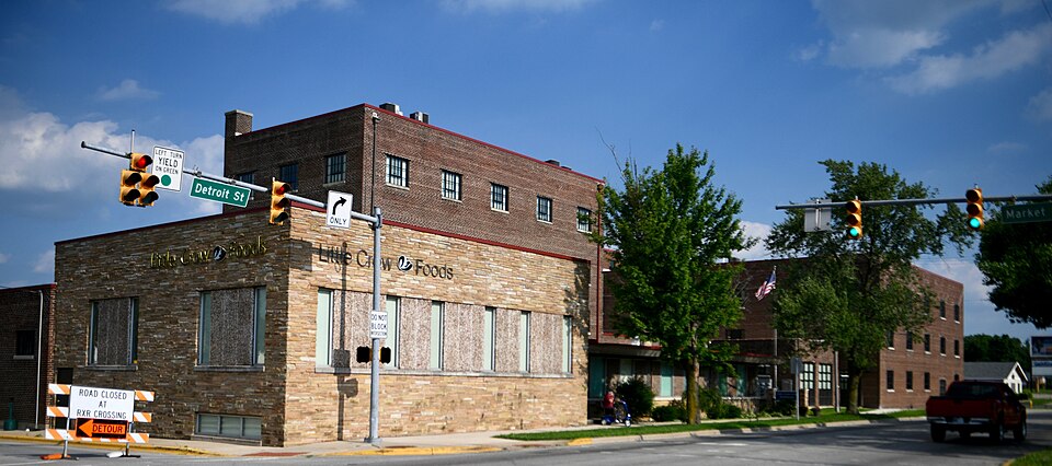
Listed on the National Register of Historic Places in 2018.
One of 17 National Register listings published here for Kosciusko County · listed in 2018 · category: Building.
Sources: the National Register database, National Park Service
The chapter on Wayne Township in Biographical and Historical Reocrd of Kosciusko County, published 1887 names Warsaw. This is what it says, exactly as the scans read.
The tirst settlements were made during the summer of 1834, by Peter Warner, William Kelly, John Knowles, Arnold Cain, William C. (iraves, James Robinson and James Comstock, all of whom located west of Warsaw. The following year Metcalf Peck, Daniel Webb, Charles Sleeper, John AV. Morris, Andrew R. Willis and John Pittenger located.
Passage source: Biographical and Historical Reocrd of Kosciusko County, published 1887.
Warsaw was named by Hon. John B. Chapman, in honor of the capital of Poland. Although this beautiful city did not pass through such fearful ordeals as did its namesake, yet the conflicts that ensued befoi'e the county seat was finally located, at times bade fair to open hostilities between rival villages.
Passage source: Biographical and Historical Reocrd of Kosciusko County, published 1887.
Machine-read from a century-old scan, so expect the errors a machine makes: misspelled names, dropped words, stray characters.
Read the whole chapter on Wayne Township - 9,168 words on its settlement, mills, schools and churches.
Regional context, not property-specific evidence. The federal mineral resources record lists 4 workings within 5 miles of Little Crow Milling Company Factory: 2 producers, 2 past producers. 2 still produce. What was taken out: Sand and Gravel, Construction, Stone. Distance is straight-line from the map coordinates, so a quarry counted here may appear on a neighbouring settlement's page as well.
| Where | Site | Commodity | Status | Recorded |
|---|---|---|---|---|
| Warsaw Street Dept. | Stone | Producer | ||
| Fuller's Sand & Gravel Pit | Sand and Gravel, Construction | Past Producer | ||
| G. and G. Sand and Gravel Pit | Sand and Gravel, Construction | Past Producer | ||
| Kosciusko Co. Hwy. Dept. | Sand and Gravel, Construction | Producer |
Regional context, not property-specific evidence. The National Weather Service names Warsaw, the town this property stands in, in 75 storm reports between 1993 and 2026: 55 thunderstorm wind, 14 hail, 3 lightning, 1 heavy rain. The reports record 1 death. Each account below is quoted exactly as the forecast office filed it, from the NOAA Storm Events Database, and each date opens the federal record of that event.
| When | Event | Place named | Harm | What the report says |
|---|---|---|---|---|
| July 2014 | Thunderstorm Wind | Warsaw | 1 killed | Emergency management officials reported a large, rotten tree fell onto the bedroom of a mobile home in the Fairlane Mobile Home Park. Two adults and two children were inside the home at the time. One child escaped the impacted room, but a 14 year old male did not and was subsequently killed. |
| July 1998 | Thunderstorm Wind | Warsaw | $500,000 | NUMEROUS TREES DOWN IN TOWN. ONE HOME COMPLETELY DESTROYED BY LARGE FALLEN TREE WHICH CRUSHED THE THEN UNOCCUPIED HOME. A TENTS AT THE COOK CHAPEDL CHURCH WERE BLOWN AWAY AND NEVER FOUND. SEVERAL OTHER HOMES SUFFERED MINOR TO MODERATE DAMAGE ESPECIALLY TO ROOFS FROM FALLEN TREES AND LIMBS. |
| September 2000 | Lightning | Warsaw | $150,000 | Lightning struck a barn causing a fire which gutted the barn and its contents. |
| August 1993 | Thunderstorm Wind | Warsaw | $50,000 | Antennas and trees were downed, and roofs were damaged. |
| May 2007 | Lightning | Warsaw | $40,000 | Fire officials were dispatched to a residence in the Harrison Landing subdivision of Warsaw where lightning struck a house. The fire was contained within 30 minutes. No one was injured in the fire. Damage was estimated at around $40,000. |
| August 2022 | Thunderstorm Wind | Warsaw | $20,000 | Several trees are down in the neighborhood. Some of the trees are blocking the road. |
| August 2001 | Lightning | Warsaw | $20,000 | Lightning apparently started a fire which destroyed a barn near the intersection of CR 450S and County Farm Road. The remains of the barn were discovered around 1:20 am EST by a Kosciusko County Sheriff's deputy on routine patrol. |
| May 2007 | Thunderstorm Wind | Warsaw | $15,000 | A maple tree fell onto a business in Winona Lake causing roof damage to the building. |
| May 2025 | Thunderstorm Wind | Warsaw | $10,000 | Tree and power lines down near CR 300 E and Old US 30. |
| July 2024 | Thunderstorm Wind | Warsaw | $10,000 | Trees down at Lake Street. Power is out over eastern Warsaw. |
| July 2007 | Flash Flood | Warsaw | $10,000 | Several roads in the northern part of the county, including the city of Warsaw, had up to a foot of flowing water on them. 5 roads in Warsaw were closed for a period of time. |
| April 2011 | Thunderstorm Wind | Warsaw | $6,000 | An off duty NWS employee found a 12 inch diameter tree had fallen on a mobile home on Wexford Place in Warsaw. The report initially came in from the Warsaw Times Union newspaper. The west side of the structure suffered damage as branches penetrated the roof. Damage is estimated around $6,000. |
| July 2022 | Thunderstorm Wind | Warsaw | $3,500 | Three large trees down. |
| August 2022 | Thunderstorm Wind | Warsaw | $2,000 | Tree limbs of 1 to 2 feet in diameter were snapped at 920 Anchorage Rd. |
| July 2022 | Thunderstorm Wind | Warsaw | $2,000 | Large tree on a power line. |
| April 2026 | Hail | Warsaw | $1,000 | Amateur radio reports 1 inch hail at the Stonehenge Golf Course. |
| July 2022 | Thunderstorm Wind | Warsaw | $1,000 | Two foot diameter tree down. |
| July 2022 | Thunderstorm Wind | Warsaw | $1,000 | A tree down across road. |
| August 2021 | Thunderstorm Wind | Warsaw | $500 | Numerous tree limbs were downed around town. |
| August 2022 | Thunderstorm Wind | Warsaw | - | An NWS Employee estimated a 60 mph wind gust. |
| August 2021 | Thunderstorm Wind | Warsaw | - | Multiple trees down in the Warsaw and Winona Lake area. |
| August 2020 | Thunderstorm Wind | Warsaw | - | Local media shared pictures of several large tree branches blown down. |
| May 2019 | Thunderstorm Wind | Warsaw | - | The public reported tree branches were blown down with the top portion of a chimney being blown off the roof. |
| May 2019 | Thunderstorm Wind | Warsaw | - | Local fire officials reported roof damage to the Economy Lodge on the east side of Warsaw. Numerous trees were reported down in both Warsaw and Winona Lake. |
| August 2018 | Tornado (EF1) | Warsaw | - | An NWS survey of damage confirmed a low end EF-1 tornado touched down in Warsaw |just southeast of Pike lake and moved through a subdivision causing mainly tree damage. The tornado crossed US-30 and paralleled County Road 75 N, continuing to uprooted trees, snapping tree trunks and topping trees. Several homes and cars were impacted by tree debris. In addition several power poles were snapped. Minor |roofing and siding damage occurred to some homes as well. The tornado curved to the south slightly, eventually lifting east of North County Road 450 East. Wind speeds were estimated at around 90 mph. ||The tornado occurred along the northern edge of a broader wind damage|swath of up to 250 yards. Damage here was much more sporadic with|estimated winds of 60-65 mph. |
| March 2017 | Thunderstorm Wind | Warsaw | - | Local law enforcement estimated wind gusts to 70 mph. |
| June 2017 | Thunderstorm Wind | Warsaw | - | An off duty NWS employee reported a tree limb was blown down. |
| July 2017 | Thunderstorm Wind | Warsaw | - | The public reported a healthy, one foot diameter tree was blown down onto a garage. |
| July 2017 | Thunderstorm Wind | Warsaw | - | A trained spotter reported a large oak tree limb down near County Road 225 East and 100 North. |
| June 2016 | Thunderstorm Wind | Warsaw | - | The public reported a tree was blown down across 7th Street and Kings Highway. |
| May 2015 | Thunderstorm Wind | Warsaw | - | The public reported over a dozen trees and tree limbs were blown down along the Winona Lake Cycling and Walking trails. |
| July 2014 | Thunderstorm Wind | Warsaw | - | Emergency management officials reported numerous trees and power lines down across the county. |
| June 2014 | Thunderstorm Wind | Warsaw | - | Law enforcement officials reported a tree was blown down onto Wooster Road. |
| July 2014 | Hail | Warsaw | - | Public reports of one half to three quarter inch diameter hail were received. |
| July 2013 | Thunderstorm Wind | Warsaw | - | The public reported a one foot diameter tree limb down onto a residence. |
| June 2013 | Thunderstorm Wind | Warsaw | - | A trained spotter estimated a 60 mph wind gust. Penny size hail was also observed. |
| June 2013 | Thunderstorm Wind | Warsaw | - | An off duty NWS employee estimated 55 to 60 mph winds with the outflow from a thunderstorm, with small tree limbs were falling. |
| June 2012 | Thunderstorm Wind | Warsaw | - | A trained spotter reported multiple trees and power lines down in the Warsaw area. Estimated wind gusts of 65 to 70 mph occurred for approximately 7 minutes. |
| August 2012 | Thunderstorm Wind | Warsaw | - | Law enforcement officials reported numerous trees were blown down in Warsaw, Winona Lake and northern portions of the county. |
| May 2011 | Hail | Warsaw | - | The public reported pea to nickle size hail falling on the southwest side of Warsaw for six minutes. |
| June 2011 | Thunderstorm Wind | Warsaw | - | An off duty NWS employee reported large branches down west northwest of Warsaw. |
| June 2010 | Thunderstorm Wind | Warsaw | - | An off duty NWS employee reported a ten inch diameter branch down southeast of Warsaw. |
| May 2010 | Thunderstorm Wind | Warsaw | - | An off-duty NWS employee reported a tree branch down onto a power line. |
| August 2008 | Thunderstorm Wind | Warsaw | - | Law enforcement officials reported tree limbs and power lines down across the southern half of the county. |
| December 2007 | Thunderstorm Wind | Warsaw | - | A nearly 40 foot tall tree was blown down by thunderstorm winds. |
| June 2006 | Thunderstorm Wind | Warsaw | - | Several trees were blown down with a 75 mph wind gust being recorded just south southwest of North Webster. |
| May 2006 | Thunderstorm Wind | Warsaw | - | Several large trees down. |
| May 2005 | Heavy Rain | Warsaw | - | 2.45 inches of rain reported between 630 and 730 pm EST. Ponding of water noted on roads in the area. |
| May 2004 | Thunderstorm Wind | Warsaw | - | An off duty NWS employee estimated wind gusts to 60 MPH in Warsaw. |
| July 2004 | Hail | Warsaw | - | Reported on US 30. |
| July 2004 | Thunderstorm Wind | Warsaw | - | Trees reported knocked down. |
| July 2003 | Thunderstorm Wind | Warsaw | - | A trained spotter reported large tree limbs down west of Warsaw. |
| September 2002 | Thunderstorm Wind | Warsaw | - | Law enforcement reported trees were reported blown down in Warsaw, Leesburg and Milford. |
| August 2001 | Thunderstorm Wind | Warsaw | - | Tree blown down on SR 25. |
| August 2001 | Thunderstorm Wind | Warsaw | - | Trees blown down. |
| August 2001 | Thunderstorm Wind | Warsaw | - | Two oak trees completely uprooted at the corner of High and Market Streets in downtown Warsaw. |
| August 2001 | Thunderstorm Wind | Warsaw | - | Trees blown down. |
| August 2000 | Thunderstorm Wind | Warsaw | - | Trees down. |
| April 1999 | Thunderstorm Wind | Warsaw | - | Thunderstorm wind gusts of 55 to 60 MPH reported by an off-duty NWS employee. |
| July 1998 | Thunderstorm Wind | Warsaw | - | WIND DAMAGE - POWER LINES DOWN AT SR-25 AND CR-100 SOUTH AND NEAR ETNA GREEN. |
No historic map-sheet match is published for this property yet. That does not mean no map exists. This record needs a coordinate-quality review before it can be joined to a sheet boundary. Browse the county's mapped places while that work is pending.
Other National Register properties close enough to walk or drive between, ordered by distance from this one. Both positions come from the same geocoding pass that matched these properties to their map sheets.
| Photograph | Property | Distance | Listed |
|---|---|---|---|
 | Kosciusko County Jail | 0.2 miles | 1978 |
 | Warsaw Cut Glass Company | 0.2 miles | 1984 |
| Warsaw Courthouse Square Historic District (Boundary Increase) | 0.2 miles | 1993 | |
 | Warsaw Courthouse Square Historic District | 0.2 miles | 1982 |
 | East Fort Wayne Street Historic District | 0.3 miles | 1993 |
 | Justin Zimmer House | 1.6 miles | 1991 |
| National Archives record | The nomination case file for reference 100002488 in Record Group 79. |
| Kosciusko County | All 17 listed properties in this county. |