 Block
From the record
One of 10 National Register listings published here for Jennings County · listed in 2022 · category: Structure.
Sources: the National Register database, National Park Service
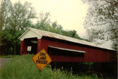
Listed on the National Register of Historic Places in 2022.
One of 10 National Register listings published here for Jennings County · listed in 2022 · category: Structure.
Sources: the National Register database, National Park Service
Regional context, not property-specific evidence. The National Weather Service names Scipio, the town this property stands in, in 14 storm reports between 1994 and 2025: 5 hail, 5 thunderstorm wind, 2 flood, 1 flash flood. The reports record 1 injury. Each account below is quoted exactly as the forecast office filed it, from the NOAA Storm Events Database, and each date opens the federal record of that event.
| When | Event | Place named | Harm | What the report says |
|---|---|---|---|---|
| January 2008 | Thunderstorm Wind | Scipio | 1 hurt, $20,000 | A man suffered cuts and scratches when his trailer was damaged by thunderstorm winds. The man was not seriously injured. |
| January 2008 | Thunderstorm Wind | Scipio | $20,000 | Five storage sheds blew down and two decks separated from mobile homes due to damaging thunderstorm winds. High winds also pushed a car off a road. Winds tore off parts of an elementary school's roof. Trees and power lines were reported down around the area. |
| January 2008 | Thunderstorm Wind | Scipio | $5,000 | A house trailer was flipped due to damaging thunderstorm winds. |
| January 2008 | Thunderstorm Wind | Scipio | $5,000 | Trees and power lines were reported down across the county due to damaging thunderstorm winds. |
| January 2012 | Flood | Scipio | $500 | Water was reported over Highway 7 near Scipio due to heavy thunderstorm rainfall. |
| June 2010 | Flood | Scipio | $500 | Several roads were reported flooded, especially in low lying areas. |
| June 2008 | Flash Flood | Scipio | $500 | Considerable flooding was reported with two water rescues needed in the northern part of the county. |
| July 2012 | Hail | Scipio | - | Quarter sized hail was almost covering the ground in this location. |
| June 2010 | Funnel Cloud | Scipio | - | A wall cloud with rotation was observed near the intersection of County Road 300 N and 900 W. |
| March 2025 | Hail | Scipio | - | no account filed |
| July 2012 | Hail | Scipio | - | no account filed |
| July 2004 | Thunderstorm Wind | Scipio | - | no account filed |
| March 1997 | Hail | Scipio | - | no account filed |
| June 1994 | Hail | Scipio | - | no account filed |
No historic map-sheet match is published for this property yet. That does not mean no map exists. This record needs a coordinate-quality review before it can be joined to a sheet boundary. Browse the county's mapped places while that work is pending.
Other National Register properties close enough to walk or drive between, ordered by distance from this one. Both positions come from the same geocoding pass that matched these properties to their map sheets.
| Photograph | Property | Distance | Listed |
|---|---|---|---|
 | Annadale | 7.4 miles | 2007 |
 | North Vernon Downtown Historic District | 7.5 miles | 2006 |
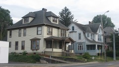 | Walnut Street Historic District | 7.5 miles | 2006 |
 | State Street Historic District | 7.8 miles | 2007 |
| National Archives record | The nomination case file for reference 100008062 in Record Group 79. |
| Jennings County | All 10 listed properties in this county. |