 Block
From the record
10 National Register listings published here.
Sources: the National Register database, National Park Service
43 topographic sheets cover 22 settlements here, and 10 properties are on the National Register of Historic Places.
10 National Register listings published here.
Sources: the National Register database, National Park Service
Every property in this county listed on the National Register of Historic Places, with the year it was listed and the federal nomination document.
| Photograph | Property | Type | Listed | Reference |
|---|---|---|---|---|
 | Annadale | building | 2007 | 06001292 |
| Benville Bridge | structure | 1996 | 96000789 | |
| Edward's Ford Bridge | structure | 1996 | 96000788 | |
| Hicklin House and Settlement | site | 2023 | 100008661 | |
| James Covered Bridge | structure | 2022 | 100008061 | |
 | North Vernon Downtown Historic District | district | 2006 | 06000306 |
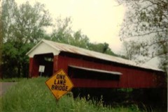 | Scipio Covered Bridge | structure | 2022 | 100008062 |
 | State Street Historic District | district | 2007 | 06001290 |
 | Vernon Historic District | district | 1976 | 76000024 |
 | Walnut Street Historic District | district | 2006 | 06000855 |
Jennings County has 2 covered bridges on the National Register. Each is a listed structure with a federal nomination on file.
| James Covered Bridge | Listed 2022 | |
| Scipio Covered Bridge | Listed 2022 |
Every wildfire the federal occurrence database records inside this county: 4 of them, burning about 4 acres. None started naturally and 1 was recorded as arson. Each settlement page carries the fires within five miles of it.
| Reported cause | Fires |
|---|---|
| Missing data/not specified/undetermined | 1 |
| Arson/incendiarism | 1 |
| Debris and open burning | 1 |
| Equipment and vehicle use | 1 |
The five largest, by the area the report gives. One of them was set deliberately.
| Date | Cause | Size | Reported by | Name on the report |
|---|---|---|---|---|
| 24 March 2016 | Missing data/not specified/undetermined | 1.0 acres | Big Oaks National Wildlife Refuge | I ROAD SOUTH |
| 24 March 2016 | Arson/incendiarism | 1.0 acres | Big Oaks National Wildlife Refuge | I ROAD NORTH |
| 18 November 2016 | Debris and open burning | 1.0 acres | Big Oaks National Wildlife Refuge | FENCE FIRE |
| 23 October 2010 | Equipment and vehicle use | 1.0 acres | Big Oaks National Wildlife Refuge | GRAHAM CREEK |
Every settlement page carries the fires within five miles of it - see the settlement index below.
The NOAA Storm Events Database holds 176 reports for this county, causing no deaths, 12 injuries and about $2,024,450 in recorded property damage. Each settlement page carries the reports that name it.
| Kind of event | Reports |
|---|---|
| Thunderstorm Wind | 91 |
| Hail | 41 |
| Flash Flood | 16 |
| Tornado | 13 |
| Flood | 11 |
| Lightning | 2 |
| Funnel Cloud | 2 |
The most serious of them, by death, then injury, then recorded damage. The accounts are quoted exactly as the forecast office filed them.
| When | Event | Place named | Harm | What the report says |
|---|---|---|---|---|
| April 1974 | Tornado (F3) | not stated | 5 hurt | no account filed |
| April 1999 | Thunderstorm Wind | Paris Crossing | 3 hurt, $50,000 | Wind gusts estimated at between 100 and 120 miles an hour rolled a mobile home, leveled 2 barns and damaged a roof off a home. A family of 3 all received minor injuries as their mobile home was rolled. The injuries were all lacerations. A National Weather Service survey ruled downburst winds the culprit. |
| August 2024 | Lightning | Queensville | 2 hurt, $1,000 | Two persons inside the tent, an 18-year-old male and a juvenile female who was 9 months pregnant, were both injured. Both victims were treated for their injuries, and were in stable yet serious condition as of the evening of August 3rd; the baby was reported unharmed. |
| April 1967 | Tornado (F2) | not stated | 1 hurt, $25,000 | no account filed |
| January 2008 | Thunderstorm Wind | Scipio | 1 hurt, $20,000 | A man suffered cuts and scratches when his trailer was damaged by thunderstorm winds. The man was not seriously injured. |
| June 2008 | Flood | Vernon | $250,000 | Flooding occurred along the Muscatatuck River in Jennings County due to heavy rainfall. |
| April 1999 | Tornado (F3) | San Jacinto | $250,000 | A strong F3 tornado moved across the extreme southeastern part of the county significantly damaging 2 homes and destroying 4 barns. 2 high tension power line towers were toppled as well. The tornado then moved northeast out of the Indianapolis CWA. |
| June 1990 | Tornado (F2) | not stated | $250,000 | no account filed |
| March 2026 | Flash Flood | Zenas | $150,000 | Heavy rains washed out a bridge on County Road 1100 North at Wolf Creek. |
| May 2007 | Tornado (EF0) | North Vernon | $100,000 | An EF0 tornado touched down near county roads 535 W and 300 S, seven miles to the southwest of North Vernon. At this location there was significant structural damage to a barn and a metal bridge over a creek thrown several hundred feet. A portion of a roof of a house was torn off, a number of outbuildings were damaged, and the end of a tool shed was damaged. In addition to this damage, trees also blew down during the storm. |
| June 2005 | Tornado (F1) | North Vernon | $100,000 | The remnants of Tropical Storm Arlene spawned an F1 tornado southwest of Hayden, Indiana. The tornado touched down at County Roads 500 South and 750 West and lifted at County Road 900 West and US Highway 50. Several outbuildings were damaged, and several grain bins were overturned. Numerous trees were also downed by the tornado. The tornado was on the ground for 11 minutes, with a path length of 5.3 miles and a width of 75 yards. No one was injured by the tornado. Damage amounts are estimated. |
| September 2011 | Tornado (EF1) | Hayden | $65,000 | The tornado began at approximately 12:33 AM EDT around 6 miles west of North Vernon along County Road 700 West between County Roads 150 North and 300 North. The tornado destroyed a pole barn, damaged 2 homes, overturned tractors, downed trees and telephone poles, and laid down a corn field before lifting around 12:34 AM EDT. One of the homes had its roof blown off. There were no injuries. The path was approximately a half mile long and 75 yards wide. Based on the damage, the tornado was rated an EF1 on the Enhanced Fujita scale with winds estimated near 100 mph. |
| September 2022 | Thunderstorm Wind | Brewersville | $60,000 | Thunderstorm downburst winds caused damage along Base Road from County Road 575 North to County Road 850 North, and to the northeast from that area. Several large trees were uprooted while winds downed power lines, broke off power poles, and bent flagpoles to the ground. Residences were impacted, as well as a plant farm where winds leveled a greenhouse and ripped plastic off of 2 others. |
| March 2008 | Flood | Zenas | $60,000 | Flooding occurred across numerous locations in Jennings County due to heavy rain. Many county roads were closed due to high water. Late in the day on the 18th a woman whose car was submersed by Graham Creek east of Lovett was rescued from the flood waters. Water was also being pumped out of several homes in North Vernon. |
| April 2022 | Thunderstorm Wind | Queensville | $50,000 | Thunderstorm winds pushed a mobile home off its foundation at 2515 Buckingham Drive. Nearby trees were blown into homes at both 171 Country Squire Boulevard and the intersection of Country Manor Street and Foxmoor Drive. Trees were also downed from Hayden to north of North Vernon. |
| April 2019 | Tornado (EF1) | Lovett | $50,000 | An EF1 tornado, with maximum winds estimated at up to 100 mph, destroyed a garage at a home on County Road 25 East. Debris strewn to the north and northeast and across the road. Several concrete anchors ripped out from the garage foundation. Trailer flipped and rolled 15 feet. Two cars pushed short distances, one with window blown out. Air conditioner moved on the west side of the adjacent house. Glass patio table tossed back south and damaged. Multiple trees and limbs twisted and downed. Second home on County Road 400 South sustained substantial loss of roofing including removal of all three dormers. Underside of roof of north facing front porch blown out with insulation debris caked on the north and east sides of the house. Wicker chair from front porch tossed to the left with two legs impaled into the windshield of a nearby SUV. This tornado occurred 4 miles south of North Vernon. |
| July 2004 | Lightning | Vernon | $50,000 | A garage, along with two pickup trucks, a bass boat, a lawn tractor, and other contents, was destroyed in a lightning strike fire. |
| May 2002 | Flash Flood | North Vernon | $50,000 | Parts of SR 7 and U.S. 50 flooded |
| June 1994 | Thunderstorm Wind | not stated | $50,000 | Trees were downed in the south central part of the county around Commiskey, Paris, and Paris Crossing. Some of the trees fell on houses and cars. |
| May 2002 | Flash Flood | Countywide | $50,000 | no account filed |
| May 2002 | Thunderstorm Wind | Countywide | $45,000 | Pole barn destroyed and trees downed |
| May 2022 | Thunderstorm Wind | North Vernon | $30,000 | Thunderstorm winds downed numerous trees and utility lines on northeast side of North Vernon. Trees fell mainly to the north and northeast. |
| June 1990 | Tornado (F1) | not stated | $25,000 | no account filed |
| February 2023 | Thunderstorm Wind | Brewersville | $20,000 | Thunderstorm winds downed trees and power lines. |
| January 2020 | Flood | Hayden | $20,000 | Conservation officers were called to assist 2 cars that had driven into standing water on the road near the intersection of 700W and 400S. Several other cars drove into flooded waters around the county near the same time. |
| July 2012 | Thunderstorm Wind | San Jacinto | $20,000 | Twenty trees were downed from Paris Crossing to State Route 7 in the southeast part of the county due to damaging thunderstorm wind gusts. |
| January 2008 | Thunderstorm Wind | Scipio | $20,000 | Five storage sheds blew down and two decks separated from mobile homes due to damaging thunderstorm winds. High winds also pushed a car off a road. Winds tore off parts of an elementary school's roof. Trees and power lines were reported down around the area. |
| June 2023 | Thunderstorm Wind | Commiskey | $15,000 | Thunderstorm winds downed or uprooted multiple trees, including one onto a propane tank, and blew a barn roof off along County Road 640 West near 620 South. |
| April 2020 | Thunderstorm Wind | North Vernon | $10,000 | Extensive tree damage reported via Facebook due to thunderstorm wind gusts across North Vernon. |
| October 2020 | Thunderstorm Wind | Grayford | $10,000 | Trees were downed across central Jennings county by thunderstorm wind gusts with no specific location noted. Times ranged from 605 EDT to 635 EDT. |
| May 2018 | Thunderstorm Wind | North Vernon | $10,000 | Utility lines, trees, and tree limbs were downed in this location due to damaging thunderstorm wind gusts. |
| June 2010 | Thunderstorm Wind | North Vernon | $10,000 | Trees and power lines were reported down across Jennings County. A few observations of pea sized hail were reported as well. |
| June 2008 | Thunderstorm Wind | North Vernon | $10,000 | Trees were down and there was structural damage to a restaurant due to damaging thunderstorm winds. |
| August 2006 | Tornado (F0) | San Jacinto | $10,000 | A weak tornado touched down in rural southeast Jennings County near the small town of San Jacinto on the evening of 14 August 2006. The tornado tore half of a tin roof off a farm barn, and downed several trees. It also did superficial trim damage to a home, and flipped a swingset and an old trailer. |
| June 2018 | Flash Flood | North Vernon Arpt | $8,000 | A car drove through a flooded road and stalled near the intersection of County Roads 150 East and 450 North due to thunderstorm heavy rainfall. |
| June 2017 | Flood | Nebraska | $7,000 | State Road 50 was closed at the Jennings and Ripley County line due to heavy rainfall. A semi-truck was stuck in high water. |
| May 2014 | Thunderstorm Wind | Hayden | $7,000 | Trees were downed in this location due to damaging thunderstorm wind gusts. |
| April 2011 | Thunderstorm Wind | Commiskey | $7,000 | A thunderstorm wind gust, estimated at 60 mph, was reported from this location. Trees were also reported down in and around Commiskey, from County Road 500 South to State Route 250. |
| July 2024 | Thunderstorm Wind | Vernon | $5,000 | Thunderstorm winds produced damage in Jennings County. |
| November 2014 | Thunderstorm Wind | North Vernon | $5,000 | Trees were reported down in this location due to damaging thunderstorm wind gusts. |
| February 2008 | Flood | Brewersville | $5,000 | Flooding occurred in Jennings County due to heavy rain. Several county roads were closed in Jennings County. |
| January 2008 | Thunderstorm Wind | Scipio | $5,000 | A house trailer was flipped due to damaging thunderstorm winds. |
| January 2008 | Thunderstorm Wind | Scipio | $5,000 | Trees and power lines were reported down across the county due to damaging thunderstorm winds. |
| April 2019 | Tornado (EF1) | Zenas | $3,000 | This EF1 tornado, with winds estimated at up to 95 mph, snapped and uprooted several trees along County Road 1000 North, west of County Road 740 East. This tornado occurred 12 miles northeast of North Vernon. |
| April 2011 | Thunderstorm Wind | North Vernon | $3,000 | A tree fell on a house in North Vernon due to damaging thunderstorm wind gusts. |
| May 1996 | Thunderstorm Wind | Hayden | $3,000 | no account filed |
| May 1978 | Tornado (F1) | not stated | $2,500 | no account filed |
| April 2025 | Thunderstorm Wind | North Vernon | $2,000 | Power lines downed by falling tree limbs due to damaging winds. |
| July 2016 | Flash Flood | Lovett | $2,000 | The sheriff's office reported numerous issues with flash flooding in the southern half of Jennings County due to thunderstorm heavy rainfall. The flood waters had receded by 930 AM EDT. |
| July 2008 | Flash Flood | Queensville | $2,000 | Cars were stranded in the flood waters. Flowing water was observed across some roads. |
| June 2008 | Thunderstorm Wind | North Vernon | $2,000 | Four to five foot diameter trees and power lines were blown down due to damaging thunderstorm winds. |
| June 2008 | Thunderstorm Wind | North Vernon | $2,000 | Trees and power lines were knocked down at this and numerous other locations across the county due to damaging thunderstorm winds. |
| June 1998 | Thunderstorm Wind | Vernon | $2,000 | no account filed |
| May 1996 | Thunderstorm Wind | Uniontown | $1,500 | no account filed |
| June 2022 | Thunderstorm Wind | Queensville | $1,000 | Thunderstorm winds downed tree onto County Road West 300 North. |
| May 2019 | Thunderstorm Wind | Hayden | $1,000 | A tree was down in this location due to damaging thunderstorm wind gusts. |
| March 2012 | Thunderstorm Wind | Queensville | $1,000 | A tree was reported down at the intersection of State Route 3 and County Road 500 North due to damaging thunderstorm wind gusts. |
| September 2012 | Thunderstorm Wind | Hayden | $1,000 | A 67 mph thunderstorm wind gust was measured in this location. Some limbs and small trees were downed as well. |
| August 2009 | Thunderstorm Wind | Grayford | $1,000 | A tree was downed near State Route 7 and Grayford Road due to thunderstorm wind gusts. |
| May 1996 | Thunderstorm Wind | North Vernon | $1,000 | no account filed |
The Survey's mineral resources record lists 5 workings inside this county. 2 still produce and 3 are closed or unrecorded. Each settlement page carries the workings within five miles of it.
| Commodity | Workings |
|---|---|
| Fluorine-Fluorite | 2 |
| Stone, Crushed/Broken | 2 |
| Zinc | 1 |
| Sulfur | 1 |
The least common of them first, because a county's hundredth gravel pit says nothing its first ten did not.
| Where | Site | Commodity | Status | Recorded |
|---|---|---|---|---|
| Sphalerite Occurrence Z74 | Zinc, Sulfur | Occurrence | Sphalerite | |
| Fluorite Occurrence Number 1 | Fluorine-Fluorite | Occurrence | ||
| Fluorite Occurrence Number 1 | Fluorine-Fluorite | Occurrence | ||
| Hayden Plant | Stone, Crushed/Broken | Producer | ||
| North Vernon Plant | Stone, Crushed/Broken | Producer |
Named settlements recorded in the Geographic Names Information System, each with the topographic sheets covering it. Villages, hamlets and abandoned places alike. Each is shown with the nearest named watercourse or landform and the survey quadrangle it falls on.
Sand Creek township · 47265 · On Bear Creek · Butlerville quadrangle
10 sheets, 1942 to 1986
Center township · 47265 · On Woods Branch · Butlerville quadrangle
10 sheets, 1942 to 1986
Montgomery township · 47270 · On Davis Branch · Deputy quadrangle
9 sheets, 1956 to 1990
Marion township · 47227 · On Sixmile Creek · Chestnut Ridge quadrangle
8 sheets, 1956 to 1990
Geneva township · 47273 · On Wyaloosing Creek · North Vernon quadrangle
12 sheets, 1942 to 1986