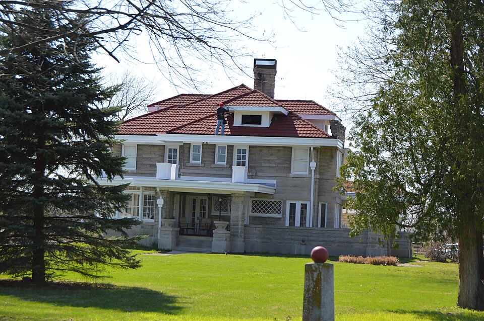
Listed on the National Register of Historic Places in 2015.
From the record
“Browne-Rafert House, also known as the Rafert-Anderson House and Browne House, is a historic home located in Fortville, Indiana. It was built in 1914, and is a two-story, Arts and Crafts movement inspired dwelling constructed of Indiana limestone.”
Wikipedia article Browne-Rafert House, CC BY-SA 4.0.
One of 13 National Register listings published here for Hancock County · listed in 2015 · category: Building.
The surface of Vernon township, like that of Buck Creek township, is exceedingly level except along the creek in the northwest corner, above Fortville, where it is rolling. Sugar creek crosses the extreme southeast corner of the township. Flat Fork creek rises near the southeast corner and flows in a northwesterly direction south of Fortville. Buck creek rises near the center of the township and flows in a southwesterly direction. Both Buck creek and Flat Fork creek, however, are simply large open ditches. The difficulty of draining Buck Creek has been discussed in the history of Buck Creek township. A Flat Fork drainage company was also organized in 1874 for the purpose of improving the outlet of Flat Fork creek. Many covered ditches have been constructed since that time, and at present the township is well drained.
One of the first school houses in Vernon township was located at the northwest corner of section 36, township 17, range 5, or just one mile south of McCordsville. It was known as school district No. 1. Another was located where Fortville now stands. School No. 9 was located at the northwest corner of the southwest quarter of section 16, township 17, range 6, or just one mile south of Fortville. School No. 11 stood at the northeast corner of the northwest quarter of section 14, township 17, range 6: school No. 5, at the southeast corner of the west half .of the northwest quarter of section 23, township 17, range 6; school No. 4, on the east side of the Greenfield and Fortville pike, near the south line of the west half of the southwest quarter of section 26, township 17, range 6; school No. 3, at the southwest corner of the southeast quarter of section 28, township 17, range 6; school No. 2, at the southwest corner of section 29, township 17, range 6; school No. 7, at the southeast corner of section i8> township 17, range 6. All of these schools have been abandoned at this time except . school No. 4, known as Denny's, and another school known as Cook's, which stands on the west side of the Greenfield and Fortville pike near the center of section 22, township 17, range 6. The pupils from the other districts now attend either at McCordsville or Fortville.
Regional context, not property-specific
evidence. The
federal wildfire occurrence database
lists 1 fire within 5 miles of Browne-Rafert House
in 2004, burning under an acre in total. None started naturally. None was recorded as arson.
Distance is straight-line from the map coordinates, so a fire counted
here may appear on a neighbouring settlement's page as well.
Reported cause
Fires
Missing data/not specified/undetermined
1
The most recent of
them, most recent first, with the day each was reported and the service
that recorded it.
Regional context, not property-specific
evidence. The federal mineral resources record lists
2 workings within 5 miles of Browne-Rafert House: 2 producers.
All of them still produce. What was taken out: Stone, Crushed/Broken, Sand and Gravel, Construction. Distance is straight-line from the
map coordinates, so a quarry counted here may appear on a neighbouring
settlement's page as well.
Regional context, not property-specific
evidence. The National Weather Service names
Fortville, the town this property stands in, in 16 storm reports between 1996 and 2025: 11 thunderstorm wind, 4 hail, 1 lightning.
No death or injury is recorded in these reports. Each account below is quoted exactly as the forecast office
filed it, from the NOAA Storm Events Database, and each date
opens the federal record of that event.
Downburst straight-line wind damage in the form of downed trees, limbs and power lines occurred on State Road 67 in Fortville at Motel Road, Industrial Drive and just north and west of the downtown area. Roofs were also blown off homes and a semi-truck was blown over as well. Two garages were reported to have collapsed also.
A one foot diameter tree was downed at Poplar and Pearl Streets due to damaging thunderstorm wind gusts. Street flooding up to 6 inches was also observed.
No historic map-sheet match is published
for this property yet. That does not mean no map exists. This record needs
a coordinate-quality review before it can be joined to a sheet boundary.
Browse the county's mapped places while that work is
pending.
Listed places nearby
3 within 8 miles
Other National Register properties close
enough to walk or drive between, ordered by distance from this one. Both
positions come from the same geocoding pass that matched these properties
to their map sheets.
Listing record. National Park Service National Register of Historic Places, listed-properties dataset, current to 2026-05-22.
Map join. Address geocoded through the United States Census geocoder, then tested against the published boundary of every sheet in the USGS Historical Topographic Map Collection.
How this page is made. Listing fields come from federal records; map-sheet coverage is a labelled coordinate-to-boundary calculation, not a source-field claim.
Wildfire. Short, Karen C. 2022. Spatial wildfire occurrence data for the United States, 1992-2020 [FPA_FOD_20221014]. 6th Edition. Fort Collins, CO: Forest Service Research Data Archive. https://doi.org/10.2737/RDS-2013-0009.6 Collected with United States Government funding and usable without additional permissions or fees.
Mines and quarries. USGS Mineral Resources Data System (MRDS) https://mrdata.usgs.gov/mrds/ A work of the United States government, no copyright under 17 U.S.C. 105.
Storms. NOAA National Centers for Environmental Information, Storm Events Database https://www.ncei.noaa.gov/stormevents/ A work of the United States government, no copyright under 17 U.S.C. 105. Narratives are quoted verbatim from the National Weather Service report and are not edited or summarised.
 Block