BlockBefore
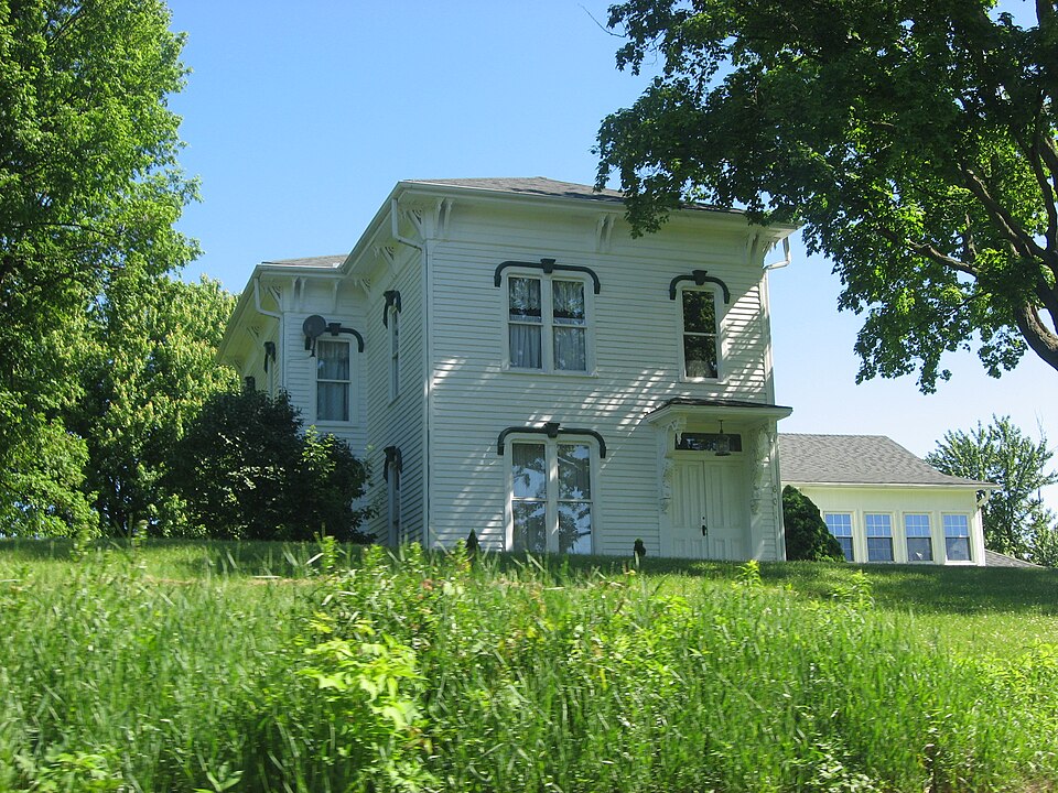
Photograph of Weller House
Photograph by Nyttend, Public domain. Via Wikimedia Commons.

Weller House

Listed on the National Register of Historic Places in 1982.

From the record

“Weller House, also known as The Old Prison Farm, is a historic home located in Pine Township, Porter County, Indiana. It was built about 1870, and is a two-story, rectangular, Italianate-style frame dwelling.”

Wikipedia article Weller House (Chesterton, Indiana), CC BY-SA 4.0.

One of 42 National Register listings published here for Porter County · listed in 1982 · category: Building.

Sources: the Wikipedia article · the case file at the National Archives · the National Register database, National Park Service · the Wikipedia article


The listing

  • What is counted as historic. The nomination lists 1 building as contributing to the listing.
  • Address. 1200 North Rd., Chesterton, 46391
  • When was it listed? April 1982
  • Category. building
  • Township. Pine township
  • National Register reference number. 82000029 - the number the National Park Service assigned this property when it was listed, and the key its nomination file is catalogued under at the National Archives.

The ground it stands on

3,471 words

This property stands in Pine Township. Counties of Porter and Lake, Indiana : Historical and Biographical, published 1882 gives that township a chapter of its own.

The chapter covers the township.

Machine-read from a century-old scan, so expect the errors a machine makes: misspelled names, dropped words, stray characters.

Read the whole chapter on Pine Township - 3,471 words on its settlement, mills, schools and churches.

Fires near this property

74 since 1992

Regional context, not property-specific evidence. The federal wildfire occurrence database lists 74 fires within 5 miles of Weller House between 1992 and 2020, burning about 52 acres in total. 4 started naturally. 1 was recorded as arson. Distance is straight-line from the map coordinates, so a fire counted here may appear on a neighbouring settlement's page as well.

Reported cause Fires
Missing data/not specified/undetermined19
Debris and open burning17
Power generation/transmission/distribution12
Railroad operations and maintenance6
Recreation and ceremony6
Natural4
Equipment and vehicle use3
Other causes2
Fireworks2
Smoking2
Arson/incendiarism1

The most recent of them, most recent first, with the day each was reported and the service that recorded it.

DateCause SizeReported by Name on the report
7 September 2005Missing data/not specified/undeterminedunder an acreIndiana Dunes National LakeshoreBEV SHOR 4
7 September 2001Power generation/transmission/distributionunder an acreIndiana Dunes National LakeshoreTAB FIRE
6 September 1992Debris and open burningunder an acreIndiana Dunes National LakeshoreTRASH PIT
26 September 1999Equipment and vehicle use3.0 acresIndiana Dunes National LakeshoreBARN
20 September 2020Railroad operations and maintenanceunder an acreIndiana Dunes National LakeshoreCHESTERON ASSIST
2 September 2001Debris and open burningunder an acreIndiana Dunes National LakeshoreDOUGLASLOO
17 September 1998Power generation/transmission/distributionunder an acreIndiana Dunes National LakeshoreSPARKLER
12 September 1998Debris and open burningunder an acreIndiana Dunes National LakeshoreSAND PIT

Every fire recorded in Porter County

Mines and quarries near this property

1 within 5 miles

Regional context, not property-specific evidence. The federal mineral resources record lists 1 working within 5 miles of Weller House: 1 past producer. None of them still produces. What was taken out: Sand and Gravel, Construction. Distance is straight-line from the map coordinates, so a quarry counted here may appear on a neighbouring settlement's page as well.

Where SiteCommodity StatusRecorded
Brown PitSand and Gravel, ConstructionPast Producer

Every working recorded in Porter County

Storms near this property

40 since 1993

Regional context, not property-specific evidence. The National Weather Service names Chesterton, the town this property stands in, in 40 storm reports between 1993 and 2025: 22 thunderstorm wind, 9 hail, 6 lightning, 2 heavy rain. No death or injury is recorded in these reports. Each account below is quoted exactly as the forecast office filed it, from the NOAA Storm Events Database, and each date opens the federal record of that event.

WhenEvent Place namedHarm What the report says
August 2009Tornado (EF2)Chesterton$1,500,000A tornado touched down in southern Chesterton east of 11th Street and southwest of South Park Drive. The tornado quickly intensified as it moved to the northeast and caused the partial collapse of a gymnasium roof at the Chesterton Junior High School. A wind gust to 105 mph was measured by an anemometer near the school. This damage along with numerous trees that were either uprooted or sheared off was caused by tornado winds reaching 110 mph. The tornado was rated EF1 at this point with a path width of 40 yards. The tornado continued to track to the northeast across the New York Central railroad tracks toward Grant Avenue where the roof of a warehouse had been peeled off and thrown about 15 yards behind the building to the north. The tornado continued to the northeast where an apartment building on Brown Avenue lost its entire roof. This damage was caused by tornado winds reaching 120 mph. The tornado damage was rated EF2 through this area with a path width of 60 yards. In the city of Chesterton, 211 structures sustained damage; 8 were completely destroyed; 54 suffered major damage, such as trees falling through roofs. The remaining 149 structures sustained damage such as missing shingles or damaged gutters. Multiple vehicles were damaged by falling debris from buildings or trees. Numerous power lines were blown down along with utility poles blown down or snapped. This EF2 damage continued northeast where an entire field of healthy old hardwood tree trunks were snapped off or uprooted. The tornado then started to slightly weaken as it approached the Interstate 94 eastbound exit/westbound entrance ramps at Indiana Highway 49. A home south of the interstate had a garage roof blown off with still numerous trees uprooted or sheared off. Tornado wind speeds here were estimated at 100 mph with an EF1 rating. Similar tree damage was noted along a path that continued to go to the northeast across Highway 49 and toward Highway 20 near Hadenfelt Road where some aluminum roofing material of a storage facility had been peeled off. Tornado wind speeds were estimated at 95 mph here and was rated EF1 with a path width of 30 yards. The tornado continued to move through a heavily forested area in the Indiana Dunes National Lakeshore, eventually crossing Highway 12. Radar imagery and an aerial survey suggests that the tornado dissipated north of Highway 12.
August 2006HailChesterton$500,000Golf ball size hail was reported at Route 20 and Bean Road.
August 2007LightningChesterton$50,000A house was struck by lightning, which ignited a fire in the attic. The house suffered extensive damage, mainly from water.
August 2005LightningChesterton$40,000A bolt of lightning struck an apartment building during a thunderstorm early Saturday morning. It is suspected of starting a smoldering fire in the insulation in the attic which was finally noticed at 315 pm in the afternoon. Damage was estimated at $30,000 for the structure, mainly the roof, and $10,000 to contents in the building.
August 2001LightningChesterton$25,000Lightning struck a tree, went down a security wire which was nailed to the tree, blew out wall sockets in a garage, traveled underground, blew out a light and a pump in a pool and finally struck a gas meter , but did not cause a fire.
July 2001LightningChesterton$10,000no account filed
August 1996LightningChesterton$10,000no account filed
December 2007Thunderstorm WindChesterton$5,000Numerous trees and utility poles were blown down.
June 1995Thunderstorm WindChesterton$5,000Large tree limbs fell on cars at Chesterton and Valparaiso. A tree also fell across Route 12 in Porter County.
August 2008Thunderstorm WindChesterton$2,000Numerous tree limbs were blown down. Part of a utility pole was blown down along with some power lines.
July 2001Thunderstorm WindChesterton$2,000no account filed
June 2010Thunderstorm WindChesterton$1,000Utility poles were blown down.
May 2025Thunderstorm WindChesterton-Large trees were blown down at Bailly Elementary School.
July 2022Thunderstorm WindChesterton-A photo shared on social media showed a large tree limb blown down on South Park Drive near Porter Avenue.
July 2022Thunderstorm WindChesterton-Large trees were blown down in the vicinity of South 2nd Street and Morgan Avenue, which brought down power lines and utility poles.
May 2020Heavy RainChesterton-Rainfall of 1.60 inches was measured in 45 minutes.
August 2016Thunderstorm WindChesterton-A willow tree approximately 40 ft was uprooted, and a 10-12 feet pear tree snapped and corn was flattened. Time estimated based on radar.
July 2016Thunderstorm WindChesterton-Numerous branches off of trees in Chesterton. In South Haven several medium size tree branches and power lines downed.
July 2015Thunderstorm WindChesterton-Six to twelve inch diameter trees were snapped about halfway up the base.
November 2013Thunderstorm WindChesterton-Large limbs and power lines were blown down.
June 2010Thunderstorm WindChesterton-Wind gusts were estimated to 60 mph.
August 2009Heavy RainChesterton-Rainfall of 2.75 inches was reported in the past 24 hours.
June 2008Thunderstorm WindChesterton-Eight inch diameter tree limbs were blown down.
May 2007Thunderstorm WindChesterton-Wind gusts estimated to 70 mph near 1100 N and IN-49 Bypass just north of the toll Road.
August 2006Thunderstorm WindChesterton-A tree was blown down, partially blocking a road.
August 2006Thunderstorm WindChesterton-Several tree limbs were blown down.
July 2005Thunderstorm WindChesterton-Trees and power lines were blown down between Chesterton and Valparaiso. The front porch on a house in Valparaiso was destroyed when a tree fell on it. Several tents at the Porter County Fairgrounds also received wind damage.
July 2017HailChesterton-no account filed
May 2014Thunderstorm WindChesterton-no account filed
June 2014Thunderstorm WindChesterton-no account filed
May 2011HailChesterton-no account filed
June 2007HailChesterton-no account filed
May 2004HailChesterton-no account filed
July 2003Thunderstorm WindChesterton-no account filed
June 2001LightningChesterton-no account filed
October 2001Thunderstorm WindChesterton-no account filed
April 1999HailChesterton-no account filed
June 1994HailChesterton-no account filed
April 1993HailChesterton-no account filed

Every storm recorded in Porter County

Map coverage status

No historic map-sheet match is published for this property yet. That does not mean no map exists. This record needs a coordinate-quality review before it can be joined to a sheet boundary. Browse the county's mapped places while that work is pending.

Listed places nearby

6 within 8 miles

Other National Register properties close enough to walk or drive between, ordered by distance from this one. Both positions come from the same geocoding pass that matched these properties to their map sheets.

Sources for this property

National Archives recordThe nomination case file for reference 82000029 in Record Group 79.
Wikipedia articleCommunity-written account of this property, licensed CC BY-SA.
Porter CountyAll 42 listed properties in this county.

Provenance

  • Listing record. National Park Service National Register of Historic Places, listed-properties dataset, current to 2026-05-22.
  • Map join. Address geocoded through the United States Census geocoder, then tested against the published boundary of every sheet in the USGS Historical Topographic Map Collection.
  • How this page is made. Listing fields come from federal records; map-sheet coverage is a labelled coordinate-to-boundary calculation, not a source-field claim.
  • Wildfire. Short, Karen C. 2022. Spatial wildfire occurrence data for the United States, 1992-2020 [FPA_FOD_20221014]. 6th Edition. Fort Collins, CO: Forest Service Research Data Archive. https://doi.org/10.2737/RDS-2013-0009.6 Collected with United States Government funding and usable without additional permissions or fees.
  • Mines and quarries. USGS Mineral Resources Data System (MRDS) https://mrdata.usgs.gov/mrds/ A work of the United States government, no copyright under 17 U.S.C. 105.
  • Storms. NOAA National Centers for Environmental Information, Storm Events Database https://www.ncei.noaa.gov/stormevents/ A work of the United States government, no copyright under 17 U.S.C. 105. Narratives are quoted verbatim from the National Weather Service report and are not edited or summarised.