BlockBefore
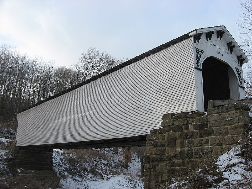
Photograph of Richland-Plummer Creek Covered Bridge
Photograph by Nyttend, Public domain. Via Wikimedia Commons.

Richland-Plummer Creek Covered Bridge

Built in 1883. Listed on the National Register of Historic Places in 1993.

From the record

One of 6 National Register listings published here for Greene County · listed in 1993 · category: Structure · built in 1883.

Sources: the case file at the National Archives · the National Register database, National Park Service · the Wikipedia article

The listing

  • What is counted as historic. The nomination lists 1 structure as contributing to the listing.
  • Listed as. Richland--Plummer Creek Covered Bridge - the National Register files a house under its owner's surname.
  • Address. Baseline Rd. over Plummer Cr., Bloomfield, 47424
  • When was it listed? June 1993
  • Category. structure
  • Township. Taylor township
  • When was it built? 1883
  • National Register reference number. 93000466 - the number the National Park Service assigned this property when it was listed, and the key its nomination file is catalogued under at the National Archives.

The ground it stands on

1,128 words

This property stands in Taylor Township. Early History of Greene County, Indiana : As Taken from the Official Records, and Compiled from Authentic Recollection, by Pioneer Settlers ... Including Brief Sketches of Pioneer Families ..., published 1875 gives that township a chapter of its own.

The chapter covers the township.

Machine-read from a century-old scan, so expect the errors a machine makes: misspelled names, dropped words, stray characters.

Read the whole chapter on Taylor Township - 1,128 words on its settlement, mills, schools and churches.

Fires near this property

20 since 2008

Regional context, not property-specific evidence. The federal wildfire occurrence database lists 20 fires within 5 miles of Richland-Plummer Creek Covered Bridge in 2008, burning about 14 acres in total. 1 started naturally. 2 were recorded as arson. Distance is straight-line from the map coordinates, so a fire counted here may appear on a neighbouring settlement's page as well.

Reported cause Fires
Debris and open burning9
Recreation and ceremony5
Missing data/not specified/undetermined2
Arson/incendiarism2
Equipment and vehicle use1
Natural1

The most recent of them, most recent first, with the day each was reported and the service that recorded it.

DateCause SizeReported by Name on the report
25 September 2008Recreation and ceremonyunder an acreIndiana State Fire Marshal's Officenot named
21 September 2008Debris and open burningunder an acreIndiana State Fire Marshal's Officenot named
1 September 2008Equipment and vehicle use1.0 acresIndiana State Fire Marshal's Officenot named
3 August 2008Missing data/not specified/undetermined1.0 acresIndiana State Fire Marshal's Officenot named
12 August 2008Naturalunder an acreIndiana State Fire Marshal's Officenot named
13 July 2008Recreation and ceremonyunder an acreIndiana State Fire Marshal's Officenot named
9 November 2008Debris and open burningunder an acreIndiana State Fire Marshal's Officenot named
23 November 2008Recreation and ceremony1.0 acresIndiana State Fire Marshal's Officenot named

Every fire recorded in Greene County

Mines and quarries near this property

10 of 14 shown

Regional context, not property-specific evidence. The federal mineral resources record lists 14 workings within 5 miles of Richland-Plummer Creek Covered Bridge: 6 occurrences, 3 past producers, 3 producers, 2 prospects. 3 still produce. What was taken out: Iron, Sand and Gravel, Construction, Stone, Clay. Distance is straight-line from the map coordinates, so a quarry counted here may appear on a neighbouring settlement's page as well.

Where SiteCommodity StatusRecorded
Bloomfield Shale PitClayPast Producer
Greene Co. Hwy. Dept.- Own CrewsStoneProducer
Bloomfield Sand & Gravel Corp.Sand and Gravel, ConstructionProducer
Greene County PlantSand and Gravel, ConstructionProducer
Furnace Bank No. 2IronOccurrence
Furnace Bank No. 2IronProspect
Richland Furnace Ore Bank No. 1IronPast Producer
Unnamed ProspectIronOccurrence

Every working recorded in Greene County

Storms near this property

46 since 1995

Regional context, not property-specific evidence. The National Weather Service names Bloomfield, the town this property stands in, in 46 storm reports between 1995 and 2026: 24 thunderstorm wind, 15 hail, 3 flash flood, 2 tornado. No death or injury is recorded in these reports. Each account below is quoted exactly as the forecast office filed it, from the NOAA Storm Events Database, and each date opens the federal record of that event.

WhenEvent Place namedHarm What the report says
February 2008Tornado (EF1)Bloomfield$1,250,000The path of the storm began just south of the town's water treatment plant, continued northeast through town, and lifted around three miles north of town. Wind speeds were estimated around 100 mph. Several dozen homes, garages, and outbuildings received significant wall and roof damage. Significant damage also occurred at the Bloomfield Elementary School. Numerous trees were also uprooted or snapped by the high winds. Power lines were reported down across the area. Damage estimate given was estimated by the Greene County Emergency Management Agency.
May 2002Flash FloodBloomfield$100,000Culverts and driveway washed out. Some county roads closed.
June 2007LightningBloomfield$44,000Lightning struck and destroyed a large barn that contained $14,000 worth of hay and farm equipment. The barn was located near County Road 300 East and County Road 400 South.
June 2008Thunderstorm WindBloomfield$35,000Large trees, branches, and utility lines were blown down in the Bloomfield area. One house was destroyed in Hashtown, an unincorporated area just east of the Bloomfield town limits off of Spring Street. Much of the damage was located south of SR 54 near Harrison, Park, Railroad, Spring, South, and Mechanic Streets. Basketball court goals were mangled by fallen trees and limbs. The roof and radio tower of a utility company were damaged.
June 2019Thunderstorm WindBloomfield$15,000Sheriff's Office reported widespread tree damage across the county due to damaging thunderstorm wind gusts.
April 2026Thunderstorm WindBloomfield$10,000Powerlines downed by thunderstorm wind gusts.
May 2013Thunderstorm WindBloomfield$10,000Some minor tree damage was noted across portions of Greene County due to damaging thunderstorm wind gusts.
January 2008FloodBloomfield$10,000Flooding occurred on the White River in Greene County, including near Elliston, due to heavy rain and snow melt.
July 2000Thunderstorm WindBloomfield$10,000Numerous trees down including one that fell on a car.
January 2008Flash FloodBloomfield$5,000Flash flooding was reported in Koleen and near Bloomfield due to heavy rain.
June 2001Thunderstorm WindBloomfield$3,000no account filed
March 2016Thunderstorm WindBloomfield$1,000A tree was blown down near the front of the courthouse due to damaging thunderstorm wind gusts. Penny to nickel sized hail was also observed.
April 2011Flash FloodBloomfield$1,000Water was reported over roadways in Bloomfield due to thunderstorm heavy rainfall.
June 1998Thunderstorm WindBloomfield$1,000Trees down on highway.
March 2024Thunderstorm WindBloomfield-Tree downed over road by thunderstorm wind gust.
May 2018HailBloomfield-This report was received via mPING and Twitter.
May 2016Thunderstorm WindBloomfield-An estimated 60 mph thunderstorm wind gust was observed in this location.
June 2010Thunderstorm WindBloomfield-A thunderstorm wind gust estimated at 60 mph was observed in this location.
June 2008Tornado (EF0)Bloomfield-A weak, very short-lived tornado moved through western Bloomfield. Some trees were uprooted. The tornado formed from a quasi-linear convective system.
June 2008Thunderstorm WindBloomfield-Several large trees were down due to damaging thunderstorm winds.
February 2006Thunderstorm WindBloomfield-Trees downed.
April 2006HailBloomfield-No property damage estimates were available.
May 2006Thunderstorm WindBloomfield-Large tree branches were broken off.
June 2006Thunderstorm WindBloomfield-Large trees were downed.
May 2005Thunderstorm WindBloomfield-Several trees were blown down.
May 2004Thunderstorm WindBloomfield-Trees down
August 2004Thunderstorm WindBloomfield-Several trees and power lines were downed in Bloomfield.
June 1995Thunderstorm WindBloomfield-Large limbs blown down at 244 South Seminary.
May 2018HailBloomfield-no account filed
May 2011HailBloomfield-no account filed
June 2007HailBloomfield-no account filed
April 2006HailBloomfield-no account filed
May 2004HailBloomfield-no account filed
April 2003Thunderstorm WindBloomfield-no account filed
May 2002HailBloomfield-no account filed
June 2001HailBloomfield-no account filed
June 1999HailBloomfield-no account filed
June 1999Thunderstorm WindBloomfield-no account filed
April 1998HailBloomfield-no account filed
March 1997Thunderstorm WindBloomfield-no account filed
April 1997HailBloomfield-no account filed
May 1996HailBloomfield-no account filed
September 1996Thunderstorm WindBloomfield-no account filed

Every storm recorded in Greene County

Map coverage status

No historic map-sheet match is published for this property yet. That does not mean no map exists. This record needs a coordinate-quality review before it can be joined to a sheet boundary. Browse the county's mapped places while that work is pending.

Listed places nearby

2 within 8 miles

Other National Register properties close enough to walk or drive between, ordered by distance from this one. Both positions come from the same geocoding pass that matched these properties to their map sheets.

Photograph PropertyDistance Listed
Greene County Courthouse2.3 miles2008
Scotland Hotel5.8 miles1993

Sources for this property

National Archives recordThe nomination case file for reference 93000466 in Record Group 79.
Wikipedia articleCommunity-written account of this property, licensed CC BY-SA.
Greene CountyAll 6 listed properties in this county.

Provenance

  • Listing record. National Park Service National Register of Historic Places, listed-properties dataset, current to 2026-05-22.
  • Map join. Address geocoded through the United States Census geocoder, then tested against the published boundary of every sheet in the USGS Historical Topographic Map Collection.
  • How this page is made. Listing fields come from federal records; map-sheet coverage is a labelled coordinate-to-boundary calculation, not a source-field claim.
  • Wildfire. Short, Karen C. 2022. Spatial wildfire occurrence data for the United States, 1992-2020 [FPA_FOD_20221014]. 6th Edition. Fort Collins, CO: Forest Service Research Data Archive. https://doi.org/10.2737/RDS-2013-0009.6 Collected with United States Government funding and usable without additional permissions or fees.
  • Mines and quarries. USGS Mineral Resources Data System (MRDS) https://mrdata.usgs.gov/mrds/ A work of the United States government, no copyright under 17 U.S.C. 105.
  • Storms. NOAA National Centers for Environmental Information, Storm Events Database https://www.ncei.noaa.gov/stormevents/ A work of the United States government, no copyright under 17 U.S.C. 105. Narratives are quoted verbatim from the National Weather Service report and are not edited or summarised.