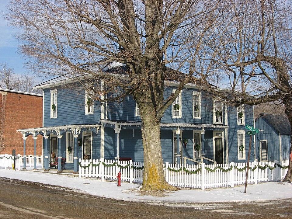
Listed on the National Register of Historic Places in 1993.
From the record
“Scotland Hotel is a historic hotel building located at Scotland, Indiana. It was built in 1879, and is a two-story, frame building with a rear section dated to the mid-1860s.”
Wikipedia article Scotland Hotel, CC BY-SA 4.0.
One of 6 National Register listings published here for Greene County · listed in 1993 · category: Building.
National Register reference number.93000467- the number the National Park Service assigned this property when it was listed, and the key its nomination file is catalogued under at the National Archives.
Old Uncle David Wallace built the first log cabin on the farm where John Summerville now lives, about a half mile south of Scotland. David Wallace and the two Anderson brothers came direct to Greene county from Edinburg, Scotland, and made the first entry of land in this settlement.
William Ferguson was born in Glasgow, Scotland, in 1793. He served in the British army for about three years, under Prince Regent George IV, and was married in Scotland, to Christiana Cullen, and their union was blessed with four children - three boys and one girl. They came to Greene county about twenty years ago, where the old lady died. Mr. Ferguson is about eighty-three years of age. He is a member of the United Presbyterian church and Sabbath school. He is in good health, and walks to Scotland for his mails !
Regional context, not property-specific
evidence. The federal mineral resources record lists
2 workings within 5 miles of Scotland Hotel: 1 occurrence, 1 prospect.
None of them still produces. What was taken out: Iron. Distance is straight-line from the
map coordinates, so a quarry counted here may appear on a neighbouring
settlement's page as well.
Regional context, not property-specific
evidence. The National Weather Service names
Scotland, the town this property stands in, in 3 storm reports between 1997 and 2014: 2 thunderstorm wind, 1 flood.
The reports record 1 death. Each account below is quoted exactly as the forecast office
filed it, from the NOAA Storm Events Database, and each date
opens the federal record of that event.
The White River in the area of Bogard Creek was extensively flooded, but not at a record stage. Recent rainfall of one half to three quarters of a inch on wet to very wet ground caused Bogard Creek to overflow. The time of the flooding was estimated based on the stage at a nearby river.||The Greene County Daily World reported that a rural Bloomfield man drowned after he apparently slipped and fell into a flood-swollen creek in Taylor Township on the morning of April the 8th. The victim, 62, lived on the property where Bogard Creek flows on U.S. 231, south of Bloomfield. The Greene County Coroner said no foul play is indicated and it looks like the victim may have been walking along the creek bank and simply fell into the water. The exact time of the incident has not been determined, but his body was found at about 11:30 AM by two close friends who had come to check on the victim. The victim's body was in two to three feet deep water and had been retrieved from the water by the friends when authorities arrived at the site, which is located in Taylor Township between County Road 400 and County Road 600.
No historic map-sheet match is published
for this property yet. That does not mean no map exists. This record needs
a coordinate-quality review before it can be joined to a sheet boundary.
Browse the county's mapped places while that work is
pending.
Listed places nearby
1 within 8 miles
Other National Register properties close
enough to walk or drive between, ordered by distance from this one. Both
positions come from the same geocoding pass that matched these properties
to their map sheets.
Listing record. National Park Service National Register of Historic Places, listed-properties dataset, current to 2026-05-22.
Map join. Address geocoded through the United States Census geocoder, then tested against the published boundary of every sheet in the USGS Historical Topographic Map Collection.
How this page is made. Listing fields come from federal records; map-sheet coverage is a labelled coordinate-to-boundary calculation, not a source-field claim.
Mines and quarries. USGS Mineral Resources Data System (MRDS) https://mrdata.usgs.gov/mrds/ A work of the United States government, no copyright under 17 U.S.C. 105.
Storms. NOAA National Centers for Environmental Information, Storm Events Database https://www.ncei.noaa.gov/stormevents/ A work of the United States government, no copyright under 17 U.S.C. 105. Narratives are quoted verbatim from the National Weather Service report and are not edited or summarised.
 Block