 Block
From the record
15 National Register listings published here.
Sources: the National Register database, National Park Service
60 topographic sheets cover 45 settlements here, and 15 properties are on the National Register of Historic Places.
15 National Register listings published here.
Sources: the National Register database, National Park Service
Every property in this county listed on the National Register of Historic Places, with the year it was listed and the federal nomination document.
| Photograph | Property | Type | Listed | Reference |
|---|---|---|---|---|
| Baxter Springs High School | building | 2014 | 14000479 | |
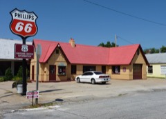 | Baxter Springs Independent Oil and Gas Service Station | building | 2003 | 03000841 |
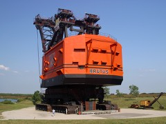 | Big Brutus | object | 2018 | 100001945 |
 | Brush Creek Bridge | site | 1983 | 83000419 |
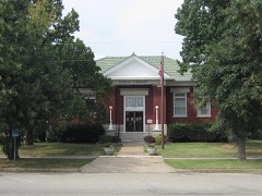 | Columbus Public Carnegie Library | building | 1987 | 87000932 |
 | Johnston Library | building | 1976 | 76000817 |
| Kansas Route 66 Historic District-East Galena | district | 2003 | 03000842 | |
| Kansas Route 66 Historic District-North Baxter Springs | district | 2017 | 100000495 | |
| Kansas Route 66 Historic District-North Baxter Springs | district | 2017 | 100000495 | |
| Kansas Route 66 Historic District-North Baxter Springs | district | 2015 | 15000141 | |
| Kansas Route 66 Historic District-North Baxter Springs | district | 2015 | 15000141 | |
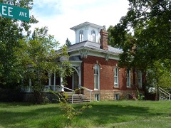 | Rial A. Niles House | building | 2006 | 06000772 |
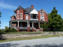 | Edgar Backus Schermerhorn House | building | 1989 | 89001146 |
| Soffietti-Boccia Grocery Store | building | 2017 | 100000793 | |
 | Williams' Store | building | 2003 | 03000843 |
Every wildfire the federal occurrence database records inside this county: 351 of them, burning about 2,324 acres. 2 started naturally and 26 were recorded as arson. Each settlement page carries the fires within five miles of it.
| Reported cause | Fires |
|---|---|
| Missing data/not specified/undetermined | 166 |
| Debris and open burning | 127 |
| Arson/incendiarism | 26 |
| Equipment and vehicle use | 12 |
| Smoking | 11 |
| Power generation/transmission/distribution | 3 |
| Fireworks | 2 |
| Recreation and ceremony | 2 |
| Natural | 2 |
The five largest, by the area the report gives. Two of them were set deliberately.
| Date | Cause | Size | Reported by | Name on the report |
|---|---|---|---|---|
| 12 January 2014 | Missing data/not specified/undetermined | 600 acres | Cherokee County | EMPIRE |
| 18 July 2017 | Missing data/not specified/undetermined | 200 acres | Cherokee County | 170036 |
| 15 February 2016 | Debris and open burning | 160 acres | Kansas Forest Service | 1600008 |
| 12 March 2015 | Debris and open burning | 80 acres | Kansas Forest Service | 64 |
| 13 March 2008 | Arson/incendiarism | 65 acres | Miami Agency | RALPH |
| 28 February 2017 | Missing data/not specified/undetermined | 60 acres | Cherokee County | 1700012 |
| 25 March 2018 | Arson/incendiarism | 50 acres | Oklahoma Division of Forestry | not named |
| 18 October 2015 | Missing data/not specified/undetermined | 50 acres | Kansas Forest Service | 1500019 |
Every settlement page carries the fires within five miles of it - see the settlement index below.
The NOAA Storm Events Database holds 745 reports for this county, causing 4 deaths, 61 injuries and about $37,274,230 in recorded property damage. Each settlement page carries the reports that name it.
| Kind of event | Reports |
|---|---|
| Thunderstorm Wind | 266 |
| Hail | 256 |
| Flash Flood | 131 |
| Tornado | 46 |
| Flood | 25 |
| Heavy Rain | 13 |
| Funnel Cloud | 8 |
The most serious of them, by death, then injury, then recorded damage. The accounts are quoted exactly as the forecast office filed them.
| When | Event | Place named | Harm | What the report says |
|---|---|---|---|---|
| May 2003 | Tornado (F3) | Melrose | 3 killed, 19 hurt, $2,700,000 | no account filed |
| March 1982 | Tornado (F3) | not stated | 1 killed, 6 hurt, $2,500,000 | no account filed |
| April 2014 | Tornado (EF2) | Baxter Spgs | 25 hurt, $10,000,000 | A survey team determined an EF2 tornado struck the town of Baxter Springs, Kansas. The tornado started near Quapaw, Oklahoma and crossed the state line into Kansas then moved through the town of Baxter Springs producing a 150 yard wide swath of damage from southwest to northeast through the center of town. Emergency management reported approximately 90 homes and 11 business were destroyed and an additional seven businesses and 85 homes suffered damage. Approximately 25 injuries were reported but no fatalities. Maximum wind speeds were estimated to be between 120 and 130 mph. |
| April 1956 | Tornado (F4) | not stated | 5 hurt, $2,500,000 | no account filed |
| August 1989 | Thunderstorm Wind | not stated | 2 hurt | no account filed |
| March 2026 | Thunderstorm Wind | Columbus | 1 hurt, $25,000 | Thunderstorm winds caused the side of a house to blow in and collapse. There was one injury. |
| September 1959 | Tornado (F2) | not stated | 1 hurt, $2,500 | no account filed |
| July 2014 | Thunderstorm Wind | Treece | 1 hurt, $1,000 | A cargo truck was blown over with one minor injury to the driver. |
| May 2011 | Thunderstorm Wind | Galena | 1 hurt | A SUV was blown off the road at 7th and Chico Road. |
| May 2009 | Thunderstorm Wind | Hallowell | $5,000,000 | A National Weather Service storm survey revealed that damaging winds impacted nearly all of Cherokee County. Widespread damage occurred in the form of downed power poles, uprooted trees, damaged structures, and damaged crops. More specifically, there were several structures that experienced roof damage while windows were blown out of both homes and automobiles. A 1000 foot transmission tower was also knocked down that was built on top of the Cherokee County court house. The Columbus High School football facilities experienced significant damage. The press box was destroyed while several power poles that lit the field were snapped or blown down. One home near Crestline experienced major structural damage. This damage appeared to of occurred from a microburst that produced a concentrated area of 90 mph winds. In Weir, the rodeo grounds and concession stand were completely destroyed, while the bath house in Scammon lost its entire roof. Several campers were also flipped over and damaged at an RV dealership in Columbus. |
| April 1996 | Thunderstorm Wind | Baxter Spgs | $5,000,000 | no account filed |
| April 2026 | Tornado (EF1) | Hallowell | $1,150,000 | A National Weather Service storm survey determined that an EF1 Tornado with estimated wind speeds of 105 mph touched down near the northeast portion of Hallowell before tracking 4.37 miles to the east. The tornado uprooted or snapped several trees, overturned several empty railcars, caused significant damaged to several grain bins, destroyed multiple outbuildings and snapped or broke numerous power poles and downed power lines. The tornado track ended approximately 1.25 miles east of Sherwin. |
| June 2007 | Flash Flood | Columbus | $1,150,000 | Another stationary band of heavy rain occurred on the night of June 11th and the morning of June 12th. In response, significant flooding occurred in all areas of the county. The Spring and Neosho rivers remained flooded, causing damage to homes and several road systems. |
| June 2007 | Flash Flood | Kniveton | $1,000,000 | The Spring River along with smaller non-stem river and creek systems experienced major flooding across the entire county. Approximately 50 homes were flooded along the Spring River. Many of the homes that were flooded are located from Baxter Springs to Riverton. Across the western section of Cherokee County, the Neosho River along with its smaller tributaries experienced major flooding. Numerous roads and bridges in these areas were washed out or destroyed. |
| December 2015 | Flood | Baxter Spgs | $750,000 | There were numerous low water crossings and rural roads that were flooded. Several homes and businesses were flooded. There was significant to extreme flooding along Shoal Creek and the Spring River around Galena to Baxter Spring's. This storm report will contain the damage estimates for the entire county for this event. |
| April 2025 | Tornado (EF1) | Lowell | $500,000 | A NWS survey determined that an EF 1 tornado touched down near Empire Lake north of Galena, KS and tracked to the northeast before crossing into Missouri at the intersection of SE Turkey Creek Road and North State Line Avenue. Along its path in Cherokee County the tornado damaged hundreds of trees, knocked over power poles and lines and damaged multiple roofs. |
| December 2015 | Flood | Lowell | $500,000 | Highway 166 and Highway 400 was closed due to flooding of the Spring River. Several roads and low water crossings were damaged from flood water. |
| May 2024 | Tornado (EF0) | Melrose | $300,000 | A NWS Survey team confirmed that an intermittent EF-0 tornado with maximum winds of 80 mph caused damage to multiple barns and numerous uprooted or snapped trees. This is an extension of a tornado out of Ottawa County, OK that occurred on the night of May 6. |
| October 1998 | Flash Flood | Countywide | $300,000 | no account filed |
| May 2020 | Hail | Columbus | $250,000 | Hail to the size of golf balls fell in the towns of Columbus and Crestline. Roof and vehicle damage occurred along the path of hail. |
| July 2013 | Flash Flood | Scammon | $250,000 | At least two homes in Scammon were flooded and evacuated. |
| May 1973 | Tornado (F2) | not stated | $250,000 | no account filed |
| April 2026 | Thunderstorm Wind | Hallowell | $200,000 | Multiple large trees were reported down with a few having fallen on homes causing minor to moderate damage to roofs and guttering. |
| October 2007 | Thunderstorm Wind | Baxter Spgs | $200,000 | A National Weather Service storm survey revealed that residential sections of southern and eastern Baxter Springs were heavily damaged by straight line winds. Numerous large trees were blown over onto houses and parked vehicles. The Sonic resturant was heavily damaged along with the rodeo grounds. |
| September 2010 | Thunderstorm Wind | Columbus | $175,000 | A portion of the Central Junior High School Gym roof was damaged by severe thunderstorm winds. This allowed rainfall to to enter the gym with nearly four inches of standing water accumulating on the gym floor. |
| April 2025 | Thunderstorm Wind | Crestline | $150,000 | Strong straight line winds downed multiple trees and damaged of destroyed several outbuildings near Messer Road and 110th Street. Debris was spread across a large area. |
| July 2010 | Tornado (EF1) | Melrose | $125,000 | A National Weather Service storm survey team confirmed an EF-1 tornado touched down with estimated winds of 90 mph. The tornado tracked east southeast along a broken path approximately three miles in length with a maximum path width of 60 yards. The tornado uprooted and snapped several large trees, blew over two large grain bins, heavily damaged two well constructed out buildings, and damaged one home. |
| July 2013 | Flash Flood | Scammon | $100,000 | There was three feet of water in a gas station just off of Highway 7 in Scammon and several people had to be rescued. |
| July 2004 | Thunderstorm Wind | Columbus | $100,000 | A derecho caused major damage to areas of extreme southeast Kansas and southwest Missouri during the early morning hours of July 4th. In Cherokee County Kansas, golf ball size hail and winds in excess of 70 mph damaged many homes and farm structures countywide. One mobile home was completely destroyed as it rolled over several times while the storm passed. Occupants had moved into a storm shelter prior to the storm and no injuries occurred. |
| April 1998 | Hail | Columbus | $100,000 | Hail, up to golf ball size, fell in the Columbus area accumulating to a depth of two inches. There was extensive car and roof damage, especially in the north part of town. Numerous reports of funnel clouds were received in the area, but no tornado touchdowns were confirmed. |
| April 1999 | Tornado (F1) | Columbus | $100,000 | no account filed |
| March 2025 | Thunderstorm Wind | Baxter Spgs | $85,000 | Several buildings had roof damage in Baxter Springs along with numerous trees down. An 85 mph wind gust was measured at the fire station. |
| March 2025 | Thunderstorm Wind | Galena | $80,000 | Numerous trees were uprooted and several roofs were taken off homes and a business in Galena, Kansas. |
| May 2020 | Hail | Baxter Spgs | $80,000 | Baseball sized hail was reported 1 mile west of Baxter Springs. Damage occurred to a home , two vehicles and several head stones at a cemetery. |
| April 2025 | Thunderstorm Wind | Galena | $75,000 | Multiple power poles and lines were reported down north of town. |
| June 1998 | Thunderstorm Wind | Countywide | $75,000 | no account filed |
| May 2024 | Tornado (EF0) | Sherwin | $64,000 | A NWS survey team determined that a tornado touched down to the northwest of Columbus near the intersection of NW Center Star and NW 40th St, downing trees in a convergent to rotational manner as it tracked northeast. As the tornado neared NW 30th St, several outbuildings were damaged to destroyed, with another barn on NW Lawton Rd experiencing door damage on its southeast and east sides. The tornado then destroyed one barn and damaged another as it crossed NW Belleview Road before dissipating. |
| June 2005 | Hail | Weir | $60,000 | no account filed |
| May 1997 | Hail | Faulkner | $60,000 | no account filed |
| August 2024 | Thunderstorm Wind | Melrose | $50,000 | Several metal buildings and barns were reported damaged or destroyed across the southwestern portion of Cherokee County. |
| May 2015 | Flash Flood | Faulkner | $50,000 | The Cherokee County Emergency Management Director estimated that nearly 30 roads were flooded and impassable due to heavy rainfall. This flooding was centered in the western third of the county. |
| February 2012 | Thunderstorm Wind | Sherman | $50,000 | Emergency management reported two barns destroyed and one with significant damage. |
| April 1994 | Thunderstorm Wind | Weir | $50,000 | Golf ball-size hail fell at Weir. Also, strong thunderstorm winds caused $180,000 damage to farm buildings, structures, and equipment throughout Cherokee County. |
| May 2011 | Hail | Columbus | $50,000 | no account filed |
| May 1999 | Flash Flood | Countywide | $50,000 | no account filed |
| August 2024 | Thunderstorm Wind | Melrose | $35,000 | A barn was reported to be blown down. |
| May 2025 | Thunderstorm Wind | Columbus | $32,000 | A tree fell down onto a house and a truck. Additionally, multiple powerlines and trees were down around town. |
| April 2026 | Thunderstorm Wind | Columbus | $30,000 | Several power poles were reported broken with downed power lines and power outages. |
| April 2026 | Thunderstorm Wind | Columbus | $25,000 | Several trees and power lines were reported down. |
| April 2026 | Thunderstorm Wind | Crestline | $25,000 | Several power lines were reported down. |
| June 2021 | Thunderstorm Wind | Columbus | $25,000 | Several large trees were downed by high winds across the city. Some minor roof and structural damage was reported. |
| May 2020 | Hail | Baxter Spgs | $25,000 | Hail to the size of golf balls was reported by the Emergency Manager. Minor roof and vehicle damage occurred. |
| August 2019 | Thunderstorm Wind | Columbus | $25,000 | A National Weather Service storm survey found evidence of 75 mph straight line winds causing some tree damage and minor structure damage west southwest of Columbus. |
| May 2019 | Tornado (EF1) | Galena | $25,000 | A National Weather Service storm survey determined that an EF-1 tornado with maximum winds of 100 mph touched down just west of the Missouri state line and traveled a half mile to the northeast before passing into Missouri. As it crossed the border the storm intensified to an EF3 with an estimated 140 mph winds. This tornado was produced by the supercell that spawned the Treece tornado and continued to produce funnel clouds very near the ground through Riverton and the north Galena area before the tornado touched down near Woodchuck Drive and caused roof damage to two homes and downed several trees as it crossed into Missouri along SE 118th Street. |
| October 2007 | Thunderstorm Wind | West Mineral | $25,000 | Straight line winds destroyed a barn along with downing power poles and numerous trees. |
| July 1996 | Thunderstorm Wind | Columbus | $25,000 | no account filed |
| April 1982 | Tornado (F1) | not stated | $25,000 | no account filed |
| June 1977 | Tornado (F1) | not stated | $25,000 | no account filed |
| September 1973 | Tornado (F1) | not stated | $25,000 | no account filed |
| May 1961 | Tornado (F2) | not stated | $25,000 | no account filed |
The Survey's mineral resources record lists 50 workings inside this county. 1 still produces and 49 are closed or unrecorded. Each settlement page carries the workings within five miles of it.
| Commodity | Workings |
|---|---|
| Lead, Zinc | 32 |
| Zinc, Lead | 14 |
| Zinc | 3 |
| Clay | 1 |
The least common of them first, because a county's hundredth gravel pit says nothing its first ten did not.
| Where | Site | Commodity | Status | Recorded |
|---|---|---|---|---|
| Weir Pit & Plant | Clay | Producer | ||
| James Orr Chubb Land | Zinc | Past Producer | 1935 | |
| Stover Tract | Zinc | Past Producer | 1935 | |
| Wade Mine | Zinc | Past Producer | 1920, 1926 | |
| Clara Jane Mine | Zinc, Lead | Past Producer | 1920, 1925 | |
| Coffee East | Zinc, Lead | Past Producer | 1944 | |
| Connor-Stone | Zinc, Lead | Past Producer | 1850, 1885 | |
| Eastern Lead and Zinc Company | Zinc, Lead | Past Producer | 1915, 1920 | |
| Eureka | Zinc, Lead | Past Producer | 1850, 1885 | |
| Galena District-Missouri-Kansas | Zinc, Lead | Past Producer | 1876 | |
| Garrett Tract | Zinc, Lead | Past Producer | 1930, 1932 | |
| John Stoskopf | Zinc, Lead | Past Producer | 1850, 1885 | |
| Kansouri and Chubb Mine | Zinc, Lead | Past Producer | 1920, 1925 | |
| North Empire | Zinc, Lead | Past Producer | 1850, 1885 | |
| Paxson | Zinc, Lead | Past Producer | Underground | |
| Peru Group Mines | Zinc, Lead | Past Producer | 1930, 1932 | |
| R. L. Van Tebra | Zinc, Lead | Past Producer | 1944 | |
| Robinson Mine | Zinc, Lead | Past Producer | 1920, 1922 | |
| A. E. Van Tebra Land | Lead, Zinc | Past Producer | 1944 | |
| Baxter Springs | Lead, Zinc | Past Producer | ||
| Bendelari Mine | Lead, Zinc | Past Producer | 1919, 1921 | |
| Bendrum,Corbus and Others | Lead, Zinc | Past Producer | 1850, 1885 | |
| Blue Diamond Mine | Lead, Zinc | Past Producer | 1920, 1925 | |
| Blue Mound Mine | Lead, Zinc | Past Producer | 1918, 1920 | |
| Brugger Tract | Lead, Zinc | Past Producer | 1935 | |
| Burns Tract | Lead, Zinc | Prospect | 1947 | |
| Chubb-Stoskopf Lease | Lead, Zinc | Past Producer | 1930, 1932 | |
| Coffee West | Lead, Zinc | Past Producer | 1944 | |
| Correll-Owens Tract | Lead, Zinc | Past Producer | 1935 | |
| Crestline and Badger - Peacock District | Lead, Zinc | Occurrence | REPLACEMENT | |
| Foley Mine | Lead, Zinc | Past Producer | 1928, 1930 | |
| Fox Mine | Lead, Zinc | Past Producer | 1920, 1922 | |
| Galena | Lead, Zinc | Past Producer | ||
| Harris Mine | Lead, Zinc | Past Producer | 1918, 1920 | |
| Hartley-Grantham Tract | Lead, Zinc | Past Producer | 1930, 1932 | |
| Henshaw Tract | Lead, Zinc | Past Producer | 1930, 1932 | |
| Kansas Line Mine | Lead, Zinc | Past Producer | 1920 | |
| Karsher and Stebbins | Lead, Zinc | Past Producer | 1920, 1925 | |
| Lucky Ok Mine | Lead, Zinc | Past Producer | 1930, 1932 | |
| Mcarthur-Sparlin Mine | Lead, Zinc | Past Producer | 1920, 1926 | |
| Mid Continent Mine | Lead, Zinc | Past Producer | 1920, 1922 | |
| Murphy | Lead, Zinc | Past Producer | 1850, 1885 | |
| Race Track Mine | Lead, Zinc | Past Producer | 1920, 1925 | |
| Roper Lease | Lead, Zinc | Prospect | 1947 | |
| Sonny Boy Mine | Lead, Zinc | Past Producer | 1930, 1932 | |
| Spira | Lead, Zinc | Past Producer | 1850, 1885 | |
| Unknown | Lead, Zinc | Past Producer | 1885, 1944 | |
| Vanetta | Lead, Zinc | Past Producer | 1944 | |
| W. H. Smith | Lead, Zinc | Past Producer | 1944 | |
| Windsor | Lead, Zinc | Past Producer | 1850, 1885 |
Named settlements recorded in the Geographic Names Information System, each with the topographic sheets covering it. Villages, hamlets and abandoned places alike. Each is shown with the nearest named watercourse or landform and the survey quadrangle it falls on.
Cherokee township · 66781 · Cherokee quadrangle
20 sheets, 1886 to 1991
No longer a settlement
Baxter Springs city · 66713 · On Willow Creek · Baxter Springs quadrangle
18 sheets, 1886 to 1991
Baxter Springs city · 66713 · On Willow Creek · Baxter Springs quadrangle
18 sheets, 1886 to 1991
Cherokee township · 66781 · Cherokee quadrangle
20 sheets, 1886 to 1991
No longer a settlement
Shawnee township · 66739 · On Little Shawnee Creek · Crestline quadrangle
19 sheets, 1886 to 1991
Cherokee township · 66781 · Cherokee quadrangle
20 sheets, 1886 to 1991
No longer a settlement
Galena city · 66739 · On Spring Branch · Baxter Springs quadrangle
18 sheets, 1886 to 1991
Ross township · 66773 · West Mineral quadrangle
20 sheets, 1886 to 1991
No longer a settlement
Galena city · 66739 · On Spring Branch · Baxter Springs quadrangle
18 sheets, 1886 to 1991
Ross township · 66773 · West Mineral quadrangle
20 sheets, 1886 to 1991
No longer a settlement
Ross township · 66773 · West Mineral quadrangle
20 sheets, 1886 to 1991
No longer a settlement
Ross township · 66773 · West Mineral quadrangle
20 sheets, 1886 to 1991
No longer a settlement
Spring Valley township · 66770 · On Brush Creek · Baxter Springs quadrangle
18 sheets, 1886 to 1991
No longer a settlement
Garden township · 66770 · On Shoal Creek · Baxter Springs quadrangle
18 sheets, 1886 to 1991
Ross township · 66724 · West Mineral quadrangle
20 sheets, 1886 to 1991
No longer a settlement
Lyon township · 66778 · Near Blue Mound · Neutral quadrangle
21 sheets, 1886 to 1991
No longer a settlement
Ross township · 66782 · Near Bell Mound · West Mineral quadrangle
20 sheets, 1886 to 1991
The vanished settlements of Cherokee County: the places named above that are no longer on the map.