 Block
From the record
One of 15 National Register listings published here for Cherokee County · listed in 2003 · category: District.
Sources: the National Register database, National Park Service
Listed on the National Register of Historic Places in 2003.
One of 15 National Register listings published here for Cherokee County · listed in 2003 · category: District.
Sources: the National Register database, National Park Service
Regional context, not property-specific evidence. The federal wildfire occurrence database lists 86 fires within 5 miles of Kansas Route 66 Historic District-East Galena between 2005 and 2020, burning about 890 acres in total. 1 started naturally. None was recorded as arson. Distance is straight-line from the map coordinates, so a fire counted here may appear on a neighbouring settlement's page as well.
| Reported cause | Fires |
|---|---|
| Debris and open burning | 48 |
| Missing data/not specified/undetermined | 24 |
| Equipment and vehicle use | 7 |
| Smoking | 3 |
| Recreation and ceremony | 2 |
| Power generation/transmission/distribution | 1 |
| Natural | 1 |
The most recent of them, most recent first, with the day each was reported and the service that recorded it.
| Date | Cause | Size | Reported by | Name on the report |
|---|---|---|---|---|
| 29 September 2015 | Debris and open burning | 2.0 acres | Kansas Forest Service | 177 |
| 2 August 2018 | Debris and open burning | 2.0 acres | Kansas Forest Service | 148 |
| 12 August 2015 | Debris and open burning | 5.0 acres | Kansas Forest Service | 156 |
| 6 July 2015 | Debris and open burning | 5.0 acres | Kansas Forest Service | 138 |
| 5 July 2015 | Missing data/not specified/undetermined | 1.0 acres | Kansas Forest Service | 137 |
| 21 July 2018 | Equipment and vehicle use | 10 acres | Kansas Forest Service | 188 |
| 15 July 2015 | Missing data/not specified/undetermined | 1.0 acres | Kansas Forest Service | 141 |
| 29 June 2015 | Debris and open burning | 1.0 acres | Kansas Forest Service | 131 |
Regional context, not property-specific evidence. The federal mineral resources record lists 508 workings within 5 miles of Kansas Route 66 Historic District-East Galena: 508 past producers. None of them still produces. What was taken out: Lead, Zinc, Zinc, Lead, Zinc. Distance is straight-line from the map coordinates, so a quarry counted here may appear on a neighbouring settlement's page as well.
| Where | Site | Commodity | Status | Recorded |
|---|---|---|---|---|
| Belleville Strip Pit | Zinc | Past Producer | 1900 | |
| Unknown | Zinc | Past Producer | 1890, 1916 | |
| W. C. Mine | Zinc | Past Producer | 1926, 1942 | |
| 1915 Mine West Shafts | Zinc, Lead | Past Producer | ||
| A. W. C. # 1 Mine | Zinc, Lead | Past Producer | ||
| A. W. C. # 3 Mine | Zinc, Lead | Past Producer | ||
| A. W. C. Mine | Zinc, Lead | Past Producer | ||
| Abc Mine | Zinc, Lead | Past Producer | ||
| Adams-Hicks Mine | Zinc, Lead | Past Producer | ||
| Admiralty Mine | Zinc, Lead | Past Producer |
Regional context, not property-specific evidence. The National Weather Service names Galena, the town this property stands in, in 38 storm reports between 1995 and 2025: 15 thunderstorm wind, 13 hail, 5 flash flood, 2 flood. The reports record 1 injury. Each account below is quoted exactly as the forecast office filed it, from the NOAA Storm Events Database, and each date opens the federal record of that event.
| When | Event | Place named | Harm | What the report says |
|---|---|---|---|---|
| May 2011 | Thunderstorm Wind | Galena | 1 hurt | A SUV was blown off the road at 7th and Chico Road. |
| March 2025 | Thunderstorm Wind | Galena | $80,000 | Numerous trees were uprooted and several roofs were taken off homes and a business in Galena, Kansas. |
| April 2025 | Thunderstorm Wind | Galena | $75,000 | Multiple power poles and lines were reported down north of town. |
| May 2019 | Tornado (EF1) | Galena | $25,000 | A National Weather Service storm survey determined that an EF-1 tornado with maximum winds of 100 mph touched down just west of the Missouri state line and traveled a half mile to the northeast before passing into Missouri. As it crossed the border the storm intensified to an EF3 with an estimated 140 mph winds. This tornado was produced by the supercell that spawned the Treece tornado and continued to produce funnel clouds very near the ground through Riverton and the north Galena area before the tornado touched down near Woodchuck Drive and caused roof damage to two homes and downed several trees as it crossed into Missouri along SE 118th Street. |
| July 2016 | Thunderstorm Wind | Galena | $10,000 | Several power poles were snapped south of Galena. |
| November 1995 | Thunderstorm Wind | Galena | $10,000 | Thunderstorm winds heavily damaged the roofs of several buildings and blew windows out of cars in Galena. |
| July 2024 | Thunderstorm Wind | Galena | $3,000 | Report of trees down in the road. |
| June 2025 | Thunderstorm Wind | Galena | $2,000 | Large tree branches and a tree was snapped off of Bagdad road south of Galena. |
| May 2024 | Thunderstorm Wind | Galena | $2,000 | Social media report of trees down. |
| May 2011 | Thunderstorm Wind | Galena | $2,000 | Emergency management reported a large tree down. |
| June 2025 | Thunderstorm Wind | Galena | $1,000 | Eight inch tree limbs were downed near Galena, Kansas. |
| May 2021 | Thunderstorm Wind | Galena | $500 | Tree limbs up to an inch in diameter were broken and some shingles were removed from a roof. |
| April 2025 | Hail | Galena | - | Quarter sized hail was reported. |
| July 2024 | Heavy Rain | Galena | - | A Mesonet station in Galena measured a 24-hour rainfall total of 3.46 inches. |
| March 2021 | Hail | Galena | - | Quarter sized hail was reported via MPing. |
| April 2020 | Thunderstorm Wind | Galena | - | A large, 10 inch diameter tree was snapped. |
| July 2020 | Hail | Galena | - | Penny sized hail was reported via MPing. |
| August 2020 | Hail | Galena | - | Quarter sized hail was reported. |
| July 2019 | Thunderstorm Wind | Galena | - | Wind gusts between 60 and 65 mph were reported on the west side of Joplin in mainly rural areas of the county. |
| May 2019 | Flash Flood | Galena | - | Flash flooding on SE 100th Street near Boston Mills Road closed the road to traffic for several hours. |
| May 2019 | Hail | Galena | - | A trained spotter reported half-dollar sized hail on Bagdad Hill, about 1 mile west of the Missouri/Kansas state line. |
| May 2017 | Hail | Galena | - | Golf ball size hail was reported near the Downstream Casino. |
| May 2017 | Hail | Galena | - | Golf ball size hail was reported near Galena. |
| March 2012 | Flood | Galena | - | Emergency management reported that the Murphy Blvd and Main Street low water bridge was closed due to flooding. |
| April 2008 | Flash Flood | Galena | - | Three to five inches of rain fell over Cherokee County. Nearly all low lying areas that typically flood during periods of excessive rainfall were flooded. Areas that were impacted the greatest occurred within the lowlands of northwest Cherokee County. Cherry Creek, Lightning Creek, and the Neosho River are all located in this region. All three of these water systems flooded, resulting in several thousand acres of farmland to flood. |
| May 2008 | Flood | Galena | - | Widespread flooding occurred across the county. More specifically, Lightning Creek, Cherry Creek, and Fly Creek all flooded low lying areas and several roads. Street flooding occurred in Baxter Springs. |
| June 2008 | Flash Flood | Galena | - | All low lying roads and areas that typically flood during episodes of flooding were flooded. The Emergency Management Director stated that there were too many flooded locations to specify to the NWS. Streams that flooded multiple locations included Cow, Lightning, Brush, Fly, and Cherry creeks. |
| September 2008 | Flash Flood | Galena | - | Widespread flooding resulted from three to five inches of rain that fell over Cherokee County. Brush Creek, Lightning Creek, Fly Creek, Cherry Creek, Cow Creek, and Deer Creek all flooded nearby county roads and lowlands. |
| September 2007 | Flash Flood | Galena | - | Low lying areas along the Spring River flooded. |
| May 2011 | Thunderstorm Wind | Galena | - | no account filed |
| May 2011 | Funnel Cloud | Galena | - | no account filed |
| June 2010 | Hail | Galena | - | no account filed |
| June 2010 | Hail | Galena | - | no account filed |
| February 2009 | Hail | Galena | - | no account filed |
| April 2003 | Hail | Galena | - | no account filed |
| September 2001 | Hail | Galena | - | no account filed |
| June 1998 | Thunderstorm Wind | Galena | - | no account filed |
| May 1997 | Hail | Galena | - | no account filed |
No historic map-sheet match is published for this property yet. That does not mean no map exists. This record needs a coordinate-quality review before it can be joined to a sheet boundary. Browse the county's mapped places while that work is pending.
Other National Register properties close enough to walk or drive between, ordered by distance from this one. Both positions come from the same geocoding pass that matched these properties to their map sheets.
| Photograph | Property | Distance | Listed |
|---|---|---|---|
 | Edgar Backus Schermerhorn House | 0.7 miles | 1989 |
 | Williams' Store | 4.1 miles | 2003 |
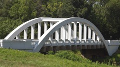 | Brush Creek Bridge | 6.2 miles | 1983 |
| Kansas Route 66 Historic District-North Baxter Springs | 6.3 miles | 2017 | |
| Kansas Route 66 Historic District-North Baxter Springs | 6.3 miles | 2015 | |
| Kansas Route 66 Historic District-North Baxter Springs | 6.9 miles | 2017 |
| National Archives record | The nomination case file for reference 03000842 in Record Group 79. |
| Cherokee County | All 15 listed properties in this county. |