 Block
From the record
4 National Register listings published here.
Sources: the National Register database, National Park Service
25 topographic sheets cover 7 settlements here, and 4 properties are on the National Register of Historic Places.
4 National Register listings published here.
Sources: the National Register database, National Park Service
Every property in this county listed on the National Register of Historic Places, with the year it was listed and the federal nomination document.
| Photograph | Property | Type | Listed | Reference |
|---|---|---|---|---|
| Bertrand House | building | 2025 | 100011614 | |
 | Oakley High School Stadium | building | 2013 | 13000150 |
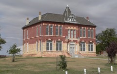 | Old Logan County Courthouse | building | 1972 | 72000511 |
 | Winona Consolidated School | building | 2005 | 05000975 |
Every wildfire the federal occurrence database records inside this county: 12 of them, burning about 2,521 acres. 1 started naturally and none was recorded as arson. Each settlement page carries the fires within five miles of it.
| Reported cause | Fires |
|---|---|
| Missing data/not specified/undetermined | 7 |
| Equipment and vehicle use | 3 |
| Debris and open burning | 1 |
| Natural | 1 |
The five largest, by the area the report gives. None of them was recorded as arson.
| Date | Cause | Size | Reported by | Name on the report |
|---|---|---|---|---|
| 15 February 2017 | Missing data/not specified/undetermined | 1,200 acres | Logan County | 17004 |
| 3 December 2008 | Missing data/not specified/undetermined | 650 acres | Kansas Counties | MONUMENT |
| 2 November 2006 | Missing data/not specified/undetermined | 513 acres | Kansas Counties | FRANK DUFF |
| 12 February 2017 | Missing data/not specified/undetermined | 50 acres | Logan County | 17005 |
| 11 November 2016 | Missing data/not specified/undetermined | 50 acres | Kansas Forest Service | 16008 |
| 22 May 2006 | Equipment and vehicle use | 35 acres | Logan County | not named |
| 11 February 2017 | Equipment and vehicle use | 20 acres | Logan County | 17003 |
| 28 June 2017 | Equipment and vehicle use | 3.0 acres | Logan County | 0W17008 |
Every settlement page carries the fires within five miles of it - see the settlement index below.
The NOAA Storm Events Database holds 837 reports for this county, causing no deaths, no injuries and about $1,809,080 in recorded property damage. Each settlement page carries the reports that name it.
| Kind of event | Reports |
|---|---|
| Hail | 485 |
| Thunderstorm Wind | 241 |
| Flash Flood | 46 |
| Tornado | 39 |
| Flood | 21 |
| Funnel Cloud | 2 |
| Lightning | 2 |
| Heavy Rain | 1 |
The most serious of them, by death, then injury, then recorded damage. The accounts are quoted exactly as the forecast office filed them.
| When | Event | Place named | Harm | What the report says |
|---|---|---|---|---|
| October 2021 | Thunderstorm Wind | Oakley Muni Arpt | $285,000 | Emergency Manager reported that 1/2 mile of power poles were blown down due to straight line winds near the city of Oakley. The downed poles resulted in no power for the city. |
| June 2014 | Flash Flood | Winona | $200,000 | Flooding occurring on many roads just north of Winona. Doppler radar estimated 5 to 7 inches of rain had fallen within 1-2 hours. County officials are in the process of closing some county roads. The Union Pacific Railroad tracks between Winona and Page City were washed out as a result of the torrential rainfall. |
| July 2013 | Hail | Oakley | $200,000 | Numerous reports from emergency manager (EM), trained spotters and the public were received in a short period of time with hail sizes ranging from 1.25 up to 2.50 in diameter. The EM estimated at least 100 vehicles in town suffered some type of hail damage, with some having windshields or other glass broken. Two med-flight aircraft also had damage. |
| July 1996 | Hail | Monument | $150,000 | no account filed |
| October 2021 | Thunderstorm Wind | Oakley | $80,000 | Logan County Emergency Manager reported a center pivot blown over just south of the city of Oakley as the line of storms moved over. |
| May 2017 | Thunderstorm Wind | Oakley Muni Arpt | $65,000 | A metal shed was blown down along with a power pole. A number of trees were also blown down, including one that was 30 ft. tall halfway between CR Cedar Crest and CR Apache Acre on Highway 83. |
| June 2011 | Thunderstorm Wind | Oakley | $65,000 | A couple of traffic signs were blown down in town. Just south and west of the intersection of U.S. 83 and U.S. 40, an irrigation sprinkler was overturned, a grain bin was buckled in and loosened from its mounting, and about 10 utility poles were broken. |
| May 2017 | Thunderstorm Wind | Oakley Muni Arpt | $52,000 | A metal machine shed was destroyed and a power pole was broken off from straight-line winds at mile marker 148 on Highway 83. |
| May 2025 | Tornado (EF2) | Elkader | $50,000 | Continuation and ending of track coming out of Scott County. This tornado destroyed oil an oil battery near Little Jerusalem Park, and damaged items at the park entrance that were bolted into concrete. Strength taken from DDC survey. Track estimated from rotation on radar, arial photos, and the few damage reports that were received. |
| July 2024 | Thunderstorm Wind | Elkader | $50,000 | A semi truck hauling a wind turbine blade was overturned due to straight line winds on Hwy 83 near the Smoky Hill River bridge. |
| May 2017 | Thunderstorm Wind | Oakley Muni Arpt | $50,000 | A Morton machinery building on CR 430 a half mile north of CR Zest was blown down from straight-line winds. Estimated time of the report from radar. |
| May 2017 | Thunderstorm Wind | Monument | $50,000 | An irrigation pivot was flipped over north of CR Ceder Crest between CR 380 and CR 390. |
| May 2017 | Thunderstorm Wind | Oakley | $50,000 | A metal machine shed was destroyed on CR 410 a half mile north of CR Broken Bow. |
| June 2014 | Tornado (EF1) | Elkader | $50,000 | Garage and barn destroyed near Rd 310 and Rd Bison. Roof of residence damaged by numerous 2x4s which penetrated roof and ceiling. No injuries reported. |
| August 1993 | Hail | Oakley | $50,000 | Baseball-size hail broke windows, windshields, dented vehicles and damaged many roofs. |
| September 2014 | Thunderstorm Wind | Monument | $36,000 | A metal building, a 20 by 10 foot storage shed and a carport were destroyed at a residence southeast of Monument. Time of report estimated from Doppler radar. A 7 x 20 foot trailer was moved approximately 100 feet. |
| July 2023 | Thunderstorm Wind | Mc Allaster | $28,000 | Eight broken electrical poles found snapped at base. |
| August 2011 | Thunderstorm Wind | Monument | $26,000 | A power pole was snapped one half mile south of monument. A grain bin was also blown down. Time estimated from radar. |
| August 2011 | Thunderstorm Wind | Monument | $25,000 | A semi-truck was blown over, with no injuries reported. |
| July 1979 | Tornado (F0) | not stated | $25,000 | no account filed |
| June 1962 | Tornado (F2) | not stated | $25,000 | no account filed |
| June 2014 | Thunderstorm Wind | Elkader | $15,000 | A semitrailer was rolled over due to strong thunderstorm outflow at mile marker 130 on highway 83. Time of report estimated from Doppler radar. |
| July 2011 | Thunderstorm Wind | Winona | $15,000 | A garage was destroyed, and three utility poles on the property were broken, as a result of a thunderstorm downburst. The time of the report is estimated from radar and a nearby 72 mph mesonet wind gust in Winona. |
| October 2021 | Thunderstorm Wind | Oakley Muni Arpt | $12,000 | As a line of thunderstorm moved across Interstate 70 near Oakley, a semi truck was blown over near mile marker 75. |
| June 2014 | Thunderstorm Wind | Oakley | $12,000 | High wind gusts broke out windows at the Travel Stop on I-70; minor injuries were reported from flying glass. Estimated time of report from radar. |
| July 2014 | Thunderstorm Wind | Mc Allaster | $11,000 | A grain bin was moved three feet off foundation. Roof damage occurred to outbuildings and multiple trees and tree limbs were blown down, including a 1.5 foot diameter dead tree which was blown down and moved 8-9 feet. Time of report estimated from Doppler radar. |
| July 2017 | Hail | Mc Allaster | $10,000 | Hail broke all the windows on the east side of the house. |
| July 2017 | Flash Flood | Smoky Hill | $10,000 | CR 200 just south of the CR 200 and CR Rawhide intersection was washed out causing the road to be closed. |
| June 2014 | Thunderstorm Wind | Oakley Muni Arpt | $10,000 | Semi trailer blown over in Highway 83 10 S of Oakley. Time estimated from radar. |
| May 2017 | Thunderstorm Wind | Monument | $9,000 | About six power poles were blown down beginning at the CR Cedar Crest/CR 350 intersection and on south. Some of the poles were on the road. |
| May 2011 | Thunderstorm Wind | Monument | $8,000 | Eight power poles were reported broken near Monument with all poles laying to the east. |
| April 2024 | Lightning | Elkader | $5,000 | A lightning strike started an oil tank battery on fire in southern Logan County. The fire burned for about an hour before being extinguished. |
| April 2022 | Thunderstorm Wind | Page City | $5,000 | Straight-line winds leveled an old outbuilding. The building was reported to be in poor repair prior to the storm. |
| September 2009 | Flash Flood | Page City | $5,000 | Cattle fences were washed out by flood waters. |
| September 2009 | Flood | Monument | $5,000 | Runoff from heavy rainfall the previous evening resulted in lingering flooding through the morning of September 8. KDOT reported water remaining over US Highway 40 between Monument and Oakley the following morning. |
| May 2008 | Thunderstorm Wind | Oakley | $5,000 | Numerous trees down in Oakley, including a large tree at city hall. Power lines reported down. |
| July 1994 | Hail | Winona | $5,000 | Golf ball-size hail dented vehicles and broke windshield. |
| June 2014 | Thunderstorm Wind | Oakley | $4,500 | Measured four or five 10-12 inch diameter healthy tree limbs blown down in town. |
| October 2017 | Flash Flood | Monument | $4,000 | Logan County Road Department reported the road had been washed away from the culverts on CR Zest between CR 380 and CR 390. |
| May 2013 | Thunderstorm Wind | Russell Spgs | $3,500 | Part of a roof ripped off of a metal outbuilding. Many tree limbs down...some up to eight inches in diameter. |
| July 2025 | Thunderstorm Wind | Russell Spgs | $3,000 | Around a 15 foot section of a roof from a limestone block building was blown to the east. |
| September 2009 | Thunderstorm Wind | Monument | $2,500 | Five power poles were blown over by thunderstorm winds. |
| September 2009 | Flash Flood | Russell Spgs | $2,500 | Water was reported over highway 25 in several places, within a few miles north of Russell Springs. Numerous nearby county roads were also flooded. |
| August 2007 | Flash Flood | Winona | $2,500 | Extremely heavy and persistent rainfall during the late afternoon /early evening hours on Wednesday (08/22/07) resulted in 5-6 inches of precipitation across NW and WC Logan county. Water was reported flowing over portions of county roads in western Logan county during the evening, with flooding ongoing the following morning affecting many county roads. Several roads were washed out preventing travel. |
| August 2019 | Thunderstorm Wind | Oakley | $2,000 | Local emergency management estimated 60 mph winds in Oakley. They also reported that some 12 inch tree branches had been blown down. |
| May 2017 | Thunderstorm Wind | Oakley | $2,000 | Numerous large tree limbs of assorted sizes blown down and siding blown off a house in southwest Oakley. |
| October 2017 | Flash Flood | Monument | $2,000 | Logan County road department reported the road was washed away around a 6'x8' box culvert on CR Seneca between CR 380 and CR 390 where Plum Creek crosses under CR Seneca. |
| October 2017 | Flash Flood | Monument | $2,000 | Logan County Road Department reported the road was closed due to flood waters cutting a deep ditch in CR 390 where Plum Creek flows under the road between CR Seneca and CR Rawhide. |
| October 2017 | Flash Flood | Russell Spgs | $2,000 | Logan County Road Department reported half the road on CR 240 had been washed away between CR Adobe and CR Bison where Chalk Creek flows under CR 240. |
| July 2014 | Thunderstorm Wind | Mc Allaster | $2,000 | A report received from the public via social media stated that shingles were removed from the house and numerous tree branches were blown down. time of report estimated from Doppler radar. |
| August 2010 | Thunderstorm Wind | Monument | $2,000 | A small portion of the roof of an old church was damaged. Four-inch diameter tree limbs were blown down in town. |
| July 2011 | Thunderstorm Wind | Russell Spgs | $1,500 | A thunderstorm wind gust damaged a quonset building and moved a fuel tank. |
| May 1998 | Hail | Winona | $1,500 | Hail dented pickup and damaged wheat. |
| March 2023 | Lightning | Russell Spgs | $1,250 | A lightning strike from snow showers caused damage to an oil battery and a trailer next to the oil tanks. The trailer was used for fracking. Damage to the trailer included lights and tires being burned. Three of the tanks were completely destroyed, while the fire in two others had burned out. |
| July 2025 | Thunderstorm Wind | Winona | $1,000 | Reported numerous large tree limbs down in Winona. |
| June 2021 | Thunderstorm Wind | Oakley | $1,000 | Multiple reports received of large tree limbs down of unknown size in the city of Oakley. |
| May 2017 | Thunderstorm Wind | Oakley Muni Arpt | $1,000 | A 30 ft. tall spruce tree was uprooted by straight-line winds a half mile west of Highway 83 on CR Zest. |
| July 2014 | Thunderstorm Wind | Oakley | $1,000 | Several six to eight inch diameter tree limbs were blown down. A few trees were also blown over. A couple of canopies on downtown buildings were blown off. Time of report estimated from Doppler radar. |
| May 2010 | Hail | Oakley | $1,000 | Car windows were reported broken. |
| May 2007 | Thunderstorm Wind | Oakley | $1,000 | Newspaper reported tree limbs broken and antenna poles bent. Sizes unknown. |
The Survey's mineral resources record lists 1 working inside this county. It still produces. Each settlement page carries the workings within five miles of it.
| Commodity | Workings |
|---|---|
| Sand and Gravel, Construction | 1 |
The least common of them first, because a county's hundredth gravel pit says nothing its first ten did not.
| Where | Site | Commodity | Status | Recorded |
|---|---|---|---|---|
| Siebert Oakley Sand Pit | Sand and Gravel, Construction | Producer |
Named settlements recorded in the Geographic Names Information System, each with the topographic sheets covering it. Villages, hamlets and abandoned places alike. Each is shown with the nearest named watercourse or landform and the survey quadrangle it falls on.
Russell Springs township · 67764 · On West Spring Creek · Russell Springs quadrangle
8 sheets, 1955 to 1985