 Block
From the record
4 National Register listings published here.
Sources: the National Register database, National Park Service
32 topographic sheets cover 13 settlements here, and 4 properties are on the National Register of Historic Places.
4 National Register listings published here.
Sources: the National Register database, National Park Service
Every property in this county listed on the National Register of Historic Places, with the year it was listed and the federal nomination document.
| Photograph | Property | Type | Listed | Reference |
|---|---|---|---|---|
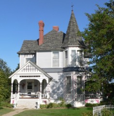 | Barbeau House | building | 2004 | 04000684 |
 | North Fork Solomon River Lattice Truss Bridge | structure | 2003 | 03000366 |
 | Norton Downtown Historic District | district | 2011 | 10001144 |
| West Sappa Creek Lattice | structure | 1990 | 89002191 |
Every wildfire the federal occurrence database records inside this county: 30 of them, burning about 5,210 acres. 3 started naturally and 2 were recorded as arson. Each settlement page carries the fires within five miles of it.
| Reported cause | Fires |
|---|---|
| Missing data/not specified/undetermined | 9 |
| Equipment and vehicle use | 6 |
| Natural | 3 |
| Other causes | 3 |
| Debris and open burning | 2 |
| Arson/incendiarism | 2 |
| Smoking | 2 |
| Fireworks | 1 |
| Misuse of fire by a minor | 1 |
| Power generation/transmission/distribution | 1 |
The five largest, by the area the report gives. None of them was recorded as arson.
| Date | Cause | Size | Reported by | Name on the report |
|---|---|---|---|---|
| 7 November 2020 | Missing data/not specified/undetermined | 2,100 acres | Norton County | PRAIRIE DOG |
| 15 October 2011 | Missing data/not specified/undetermined | 2,000 acres | Kansas Counties | ZIMMERMAN |
| 31 March 2010 | Missing data/not specified/undetermined | 600 acres | Kansas Counties | WILDLIFE MGT AREA |
| 1 April 2015 | Natural | 300 acres | Kansas Forest Service | 8 |
| 16 September 2015 | Natural | 130 acres | Kansas Forest Service | 15 |
| 4 March 2017 | Debris and open burning | 33 acres | Norton County | 1700006 |
| 20 September 2015 | Missing data/not specified/undetermined | 25 acres | Kansas Forest Service | 17 |
| 19 March 2017 | Missing data/not specified/undetermined | 8.0 acres | Norton County | 1700009 |
Every settlement page carries the fires within five miles of it - see the settlement index below.
The NOAA Storm Events Database holds 627 reports for this county, causing 1 death, 4 injuries and about $18,929,500 in recorded property damage. Each settlement page carries the reports that name it.
| Kind of event | Reports |
|---|---|
| Hail | 353 |
| Thunderstorm Wind | 224 |
| Tornado | 31 |
| Flash Flood | 9 |
| Flood | 6 |
| Lightning | 2 |
| Funnel Cloud | 1 |
| Heavy Rain | 1 |
The most serious of them, by death, then injury, then recorded damage. The accounts are quoted exactly as the forecast office filed them.
| When | Event | Place named | Harm | What the report says |
|---|---|---|---|---|
| September 2016 | Flash Flood | New Almelo | 1 killed | The North Fork of the Solomon River was out of its banks causing all of Lenora to be flooded, along with a stretch of Highway 9 coming into town as well as elsewhere in the southern part of the county. Swift water rescues occurred in the southern part of Norton county during the late evening of the third. One of these rescues involved a couple who under estimated the depth of the water over the highway and drove through the flood waters on Highway 9. The vehicle was washed off the road and caught in a tree. The couple escaped from the vehicle and climbed into the tree, remaining there until rescuers arrived. There was one direct fatality from the flooding. The individual was driving north from Graham County on county roads toward Lenora. He drove into flood waters, under estimating their depth. His vehicle was washed off the road. His body was found a quarter mile away from the vehicle. In general, the majority of the rainfall fell south of CR W. Rainfall amounts of five to seven inches were common across southern Norton County. No information was given for property damage. |
| May 2004 | Thunderstorm Wind | Norton | 3 hurt | Blowing dirt reduced visibility causing a three-car accident on highway 36 resulting in three injuries. |
| August 2023 | Hail | Almena | 1 hurt, $15,000 | The hail caused damage to a camper, siding, and broke several windows in vehicles and the house. One person was hit in the head by the hail and had a laceration. |
| June 2011 | Tornado (EF3) | Almena | $10,000,000 | A strong tornado developed just northeast of Almena and traveled roughly along Highway 383 to the Phillips county line near roads E and 14. (The tornado continued northeast for several miles into Phillips county before dissipating). One residence was completely destroyed, but a mother and her four children amazingly escaped without injury after seeking shelter in the basement. Many other farmsteads suffered significant damage to the residence itself, as well as to outbuildings, irrigation pivots, farm machinery and livestock. |
| June 2014 | Thunderstorm Wind | Almena | $2,000,000 | Many 2-3 ft. diameter trees were snapped off across town. One pine tree was also uprooted. Three or four houses in town had trees blown on them. One or two vehicles smashed under fallen trees. Part of a roof was torn off one house. |
| June 2014 | Thunderstorm Wind | Oronoque | $1,000,000 | Roof and siding damage done to houses, with trees blown onto houses and a grain bin was damaged. Estimated time of report from radar. |
| June 2011 | Tornado (EF2) | Edmond | $1,000,000 | This large tornado moved from northern Graham County into Norton County, dissipating near Norton County Road E-6 and Highway 9 west of Densmore. The tornado was still producing EF2 damage in Norton County as it destroyed utility poles, grain bins and tree rows. A farmstead suffered significant damage west of Densmore. The roof was heavily damaged, vehicles and farm implements were moved, with grain bins and outbuildings damaged or destroyed. |
| July 2009 | Hail | Norton Muni Arpt | $1,000,000 | Golf ball sized hail reported at Prairie Dog State Park, which broke windows in 60 vehicles, caused serious damage to 40 campers, and damaged cabins at the park. Flooding was confined to roadside ditches according to park personnel. Newspaper accounts placed damage to vehicles and park facilities at one million dollars. |
| June 1999 | Tornado (F3) | Norton | $1,000,000 | A large tornado dropped down just east of the town of Norton and stayed on the ground for approximately 10 miles before finally lifting north-northeast of the town of Almena. This Tornado reached around 3/4 of a mile wide at times and did major (F3) damage to a few farmsteads. Tornado also went through a stage with multiple vortices. |
| May 2008 | Flash Flood | Norton | $500,000 | Street flooding with water up to 1 foot deep was reported in the city of Norton via the National Spotter Network. Radar also indicated extremely heavy rainfall occurring across much of central Norton county at this time. Local newspapers later stated that Norton county roads incurred an estimated $500,000 in damage as a result of the heavy rainfall and flooding in the area. |
| June 2000 | Hail | Edmond | $400,000 | Thunderstorm Wind damage occurred across southeast Norton County along with some reports of Tennis Ball size Hail. Pastures destroyed and roof damage reported near Densmore. |
| June 2011 | Tornado (EF3) | Densmore | $350,000 | Storm survey team located a four-mile track of significant damage along and just south of Road S from Road 6 to Road 10. Major damage occurred to a grove of large cottonwood trees. Nearby, a farmstead received damage to outbuildings, utility poles, with the south-facing wall of the home bowed out as a result of the tornado. |
| June 2011 | Tornado (EF2) | Calvert | $300,000 | A four mile path of storm damage was surveyed southeast of Calvert. A large outbuilding at a residence was completely destroyed, irrigation pivots overturned, utility poles damaged, and the back section of a house was also of heavily damaged. |
| June 2000 | Tornado (F0) | Densmore | $250,000 | Brief Tornado near Norton/Phillips County Line. |
| May 1999 | Hail | Lenora | $200,000 | no account filed |
| September 2008 | Hail | Norton | $100,000 | Heavy damage to camper, shingles on garage and windows in RV and pickup. |
| July 2006 | Thunderstorm Wind | Lenora | $100,000 | Top of grain bin blown off. Power lines down. Shed destroyed. Trailer blown into pole. |
| June 2000 | Thunderstorm Wind | Norton | $100,000 | Thunderstorm produced around 70 MPH Wind Gusts and Golfball size Hail as it moved across Norton County. Many crops were damaged, and some windows were broken in the town of Norton. |
| November 2015 | Tornado (EF1) | Norton | $83,000 | The tornado tracked to the north-northeast. Twelve electrical poles were taken down on the south side of Highway 36 just west of the prison. The tornado also disabled KQNK radio station's ability to broadcast, and a flagpole was bent in half. A trailer house and outbuildings were also damaged. |
| June 2012 | Thunderstorm Wind | Norton Muni Arpt | $70,200 | Strong wind rolled over a camper at the airport. Numerous trees down in Norton. Eighteen electrical poles blown down across Norton. Five or so houses with the north windows blown out. Several houses with trees on the roof. The cover to a grain bin was blown 3/4 of a mile to the south-southeast. Most, if not all, of Norton without power. Large tree blown down with limbs of 3 to 4 inches in diameter broken off. Parts of roofing ripped off building down to the wood. |
| October 2023 | Tornado (EF1) | Norton Muni Arpt | $50,000 | NWS Storm Survey concluded that a brief EF-1 Tornado occurred in norther Norton County. Estimated winds were 95-105 mph along with a path width of 30 yards and path length of 0.08 miles. Tornado started at 425 CDT and ended at 426pm CDT. Damage to a large building, and other outbuildings at a residence were noted. |
| August 2023 | Thunderstorm Wind | Almena | $50,000 | Mature tree trunks snapped and many large tree limbs broken by the thunderstorm winds. An enclosed small trailer that was loaded was pushed around the corner of a shed, a wooden privacy fence was blown over, a couple electric poles were blown down. |
| September 1993 | Hail | Norton | $50,000 | Golfball sized hail broke windshields, vehicle headlights and damaged roofs resulting in $12,000 loss. |
| July 2023 | Thunderstorm Wind | Norton | $30,000 | Wind gusts of 60 MPH increased in intensity. Thunderstorm winds blew the roof off a cabin. Power is also lost at the location. |
| July 2021 | Thunderstorm Wind | Norton | $25,000 | Strong thunderstorm wind gusts estimated at 75 mph blew out the display sign at the Sonic Restaurant in Norton. The sign was approximately 15 ft wide by 20 ft across and was laying across all lanes of Highway 36. Smaller parts to the sign were scattered across the highway. |
| May 2008 | Flood | Clayton | $25,000 | The river gauge 4 miles east of Clayton remained at or above flood stage for 21 hours due to heavy rainfall during the late afternoon and evening of May 22nd. Low land flooding occurred along Prairie Dog Creek leading to Sebelius Reservoir. An unattended camper floated away when the waters rose. |
| July 2007 | Thunderstorm Wind | Reager | $25,000 | Grain bin blown over in town at grain elevator. |
| July 2007 | Thunderstorm Wind | Reager | $25,000 | Semi truck blown over 1 mile west of Reager. |
| May 1965 | Tornado (F1) | not stated | $25,000 | no account filed |
| June 2006 | Hail | New Almelo | $24,000 | Several homes and 1 school reported broken windows, with siding and roof damage from hail and wind. |
| June 2010 | Thunderstorm Wind | Norton | $15,000 | An intense thunderstorm moved southeast out of Red Willow county Nebraska during the night, producing damaging winds in and just north of Norton. A trampoline was lofted over a house, and just north of the airport a tank was rolled across the highway. A grain auger was also damaged. |
| May 2007 | Lightning | Norton | $15,000 | Lightning apparently struck a TV antenna and traveled through the electrical system of a home and ignited the wall insulation in the basement. It took four fire trucks and 13 fire fighters to contain the fire in one hour. |
| June 2011 | Tornado (EF1) | Calvert | $10,000 | Four utility poles were broken, and other minor damage occurred nearby, as this brief tornado moved northeast. |
| August 2009 | Thunderstorm Wind | Norton | $10,000 | Thunderstorm winds blew down fences, uprooted trees and broke a storefront window in the town of Norton. Time of event estimated from other storm reports and Doppler radar. |
| July 2008 | Thunderstorm Wind | Almena | $10,000 | Tree branches 3-4 inches in diameter were broken. A grain bin was damaged and a wall from an old wooden barn was blown down. |
| April 2022 | Thunderstorm Wind | Lenora | $8,000 | Straight-line winds ripped metal tin panels off a roof of a barn. |
| June 2022 | Thunderstorm Wind | Lenora | $6,000 | As a strong thunderstorm moved over the town of Lenora, a large healthy hardwood tree was split in half down the trunk. Half of the tree remained upright while the other half landed on the roof of a home and damaged several wooden fence panels. |
| May 2023 | Flash Flood | Oronoque | $5,000 | Flash flooding reported 4 miles east of Reager, KS on Highway 383. Local dispatch reported that there was one water rescue performed due to the flood conditions at the location. |
| May 2013 | Thunderstorm Wind | Almena | $5,000 | Mobile home moved four feet...ripped out tie downs. Some hay bales were rolled and calving pens flipped. Damage occurred approximately 2 miles south of Hwy 36 at Road E9. |
| July 2007 | Thunderstorm Wind | Lenora | $5,000 | Trailer home had siding blown off one side of trailer. |
| August 2005 | Thunderstorm Wind | Norton | $5,000 | Strong thunderstorm winds blew over a windmill, and removed shingles from a home. Several utility poles in the immediate area were blown down. Two large shop doors were blown off a building which landed on a car. A 5x10 foot flatbed trailer was blown across railroad tracks. Large tree branches also reported down. |
| March 1993 | Tornado (F1) | to 9 NW | $5,000 | A tornado traveled northwest at 20 mph from 4 miles northwest of Norton to 9 miles northwest of Norton. Damage was confined to an 80-foot section of barn and rolled hay bales. |
| March 1993 | Tornado (F1) | to 11.25 | $5,000 | The tornado crossed Highway 283 at the stateline before ending 0.25 mile inside Furnas County Nebraska. Damage occurred to a quonset building and hog feeder about 11 miles north of Norton. |
| August 2019 | Thunderstorm Wind | Norton | $4,000 | Thunderstorm wind damage was reported in Norton with several small tree limbs down as well as patio furniture and trash cans moved into the street. |
| June 2006 | Hail | New Almelo | $3,000 | Hail damaged crops, house siding and broke windows. |
| May 2013 | Thunderstorm Wind | Almena | $2,500 | Roof/joist damage to a pole (horse) barn approximately 1.5 miles north of Hwy 36 at Road E9. |
| September 1970 | Tornado (F2) | not stated | $2,500 | no account filed |
| June 1952 | Tornado (F2) | not stated | $2,500 | no account filed |
| May 2013 | Thunderstorm Wind | Almena | $2,000 | Power lines down in the Almena area, reported by sheriff dispatch. Time of event estimated from Doppler radar. |
| August 2011 | Hail | Lenora | $1,500 | Public reported windows were broken out of the house. |
| July 2025 | Hail | Calvert | $1,000 | A trained spotter reports hail up to 3 inches in diameter. Damage was reported to north facing windows. |
| October 2023 | Thunderstorm Wind | Norton Muni Arpt | $1,000 | A large tree trunk was split in half due to strong thunderstorm wind gusts estimated at 75 mph. |
| October 2023 | Thunderstorm Wind | Norton Muni Arpt | $1,000 | Water tank was thrown 15 feet onto the road by thunderstorm wind gusts estimated to be 70 mph. |
| August 2023 | Thunderstorm Wind | Norton Muni Arpt | $1,000 | A 10 inch diameter tree limb blown down. |
| June 2014 | Thunderstorm Wind | Norton Muni Arpt | $1,000 | Two inch diameter tree limbs were blown down and damage was done to a fence. |
| June 2013 | Thunderstorm Wind | Norton | $1,000 | A large shed with a roof had its doors open, allowing the wind to come into the building, causing the roof to be pushed away from the wall a foot or so. The wind gust also broke some 2x4s in the shed's structure. |
| July 2011 | Thunderstorm Wind | Norton | $1,000 | Wind gusts estimated at 70 mph hit Norton , damaging trees and the Downtown Sander Furniture store awning. |
| July 2002 | Thunderstorm Wind | Norton | $1,000 | House roof damaged. Debris from roof broke windows in nearby building. |
| August 2011 | Thunderstorm Wind | Lenora Muni Arpt | $500 | Severe wind gusts broke small limbs off of trees and broke at least one window. |
| July 2009 | Thunderstorm Wind | Norton Muni Arpt | $500 | Power lines were blown down in the town of Norton. |
Named settlements recorded in the Geographic Names Information System, each with the topographic sheets covering it. Villages, hamlets and abandoned places alike. Each is shown with the nearest named watercourse or landform and the survey quadrangle it falls on.
Almena-District 4 township · 67622 · On Horse Creek · Almena quadrangle
13 sheets, 1893 to 1985
Center-District 1 township · 67622 · On Wildcat Creek · Calvert quadrangle
16 sheets, 1893 to 1985
Highland-District 2 township · 67629 · On Plum Creek · Clayton quadrangle
7 sheets, 1954 to 1985
Highland-District 2 township · 67654 · Near Spring Draw · Reager quadrangle
9 sheets, 1951 to 1985
Solomon-District 3 township · 67645 · On Sand Creek · Densmore quadrangle
13 sheets, 1893 to 1985
Center-District 1 township · 67653 · On Horseshoe Branch · Devizes quadrangle
9 sheets, 1951 to 1985
Solomon-District 3 township · 67645 · On Otter Creek · Edmond quadrangle
13 sheets, 1893 to 1985
Highland-District 2 township · 67645 · On Elk Creek · Lenora West quadrangle
7 sheets, 1954 to 1985
Center-District 1 township · 67654 · On Robinson Creek · Norton quadrangle
16 sheets, 1893 to 1985
Highland-District 2 township · 67654 · Near Spring Draw · Reager quadrangle
9 sheets, 1951 to 1985