 Block
From the record
7 National Register listings published here.
Sources: the National Register database, National Park Service
38 topographic sheets cover 12 settlements here, and 7 properties are on the National Register of Historic Places.
7 National Register listings published here.
Sources: the National Register database, National Park Service
Every property in this county listed on the National Register of Historic Places, with the year it was listed and the federal nomination document.
| Photograph | Property | Type | Listed | Reference |
|---|---|---|---|---|
 | Downs Carnegie Library | building | 1987 | 87000966 |
 | Downs Missouri Pacific Depot | building | 2001 | 01001093 |
| East Fork Wolf Creek Pratt Truss Bridge | structure | 2003 | 03000361 | |
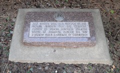 | Geodetic Center of the United States | site | 1973 | 73000772 |
 | Natoma Presbyterian Church | building | 2006 | 06001052 |
 | Osborne County Courthouse | building | 2002 | 02000392 |
 | Osborne Public Carnegie Library | building | 1987 | 87000967 |
Every wildfire the federal occurrence database records inside this county: 11 of them, burning about 2,119 acres. None started naturally and none was recorded as arson. Each settlement page carries the fires within five miles of it.
| Reported cause | Fires |
|---|---|
| Missing data/not specified/undetermined | 3 |
| Equipment and vehicle use | 3 |
| Smoking | 2 |
| Debris and open burning | 2 |
| Power generation/transmission/distribution | 1 |
The five largest, by the area the report gives. None of them was recorded as arson.
| Date | Cause | Size | Reported by | Name on the report |
|---|---|---|---|---|
| 13 March 2015 | Missing data/not specified/undetermined | 1,600 acres | Russell County | ANGEL GRASS FIRE |
| 18 February 2018 | Power generation/transmission/distribution | 250 acres | Kansas Forest Service | 180005 |
| 29 March 2015 | Smoking | 240 acres | Kansas Forest Service | 4 |
| 11 October 2020 | Equipment and vehicle use | 20 acres | Kansas Forest Service | not named |
| 30 March 2015 | Debris and open burning | 3.0 acres | Kansas Forest Service | 9 |
| 27 May 2018 | Equipment and vehicle use | 2.0 acres | Kansas Forest Service | 180013 |
| 31 May 2020 | Equipment and vehicle use | 2.0 acres | Kansas Forest Service | not named |
| 10 June 2018 | Smoking | 1.0 acres | Kansas Forest Service | 1814 |
Every settlement page carries the fires within five miles of it - see the settlement index below.
The NOAA Storm Events Database holds 583 reports for this county, causing no deaths, 14 injuries and about $16,405,000 in recorded property damage. Each settlement page carries the reports that name it.
| Kind of event | Reports |
|---|---|
| Hail | 352 |
| Thunderstorm Wind | 138 |
| Tornado | 48 |
| Heavy Rain | 24 |
| Flash Flood | 13 |
| Flood | 6 |
| Funnel Cloud | 2 |
The most serious of them, by death, then injury, then recorded damage. The accounts are quoted exactly as the forecast office filed them.
| When | Event | Place named | Harm | What the report says |
|---|---|---|---|---|
| May 2007 | Tornado (EF2) | Osborne | 11 hurt, $150,000 | A tornado sat down south of Osborne and moved north into town. The twister destroyed 2 mobile homes, damaged roofs, fences, cars and windows, and damaged 2 restaurants. The Pizza Hut sustained minor damage and several employees car windows were blown out. Across the road, the Circle Inn lost a large part of their roof, a couple of outside walls, and substantial damage happened to the interior portion of the restaurant. A couple of semi-trailers were blown around and one ended up on top of another car. Eleven people were injured, none seriously, and were treated at the Osborne County Memorial Hospital. The Osborne County Sheriff's office reported the most severe injury was a broken arm. (sources: Osborne County Farmer newspaper, Osborne County Sheriff's office, and the Osborne County Emergency Management Agency). |
| May 1950 | Tornado (F2) | not stated | 2 hurt, $25,000 | no account filed |
| May 2002 | Thunderstorm Wind | Portis | 1 hurt, $100,000 | no account filed |
| April 1990 | Tornado (F1) | not stated | $2,500,000 | no account filed |
| May 2021 | Flash Flood | Natoma | $2,000,000 | no account filed |
| June 2005 | Hail | Downs | $2,000,000 | no account filed |
| May 2024 | Hail | Downs | $1,000,000 | Hail ranging in size from ping pong balls to baseballs was reported across Downs. |
| June 2011 | Flood | Portis | $1,000,000 | Heavy rain in excess of 4 inches caused flooding in northeast Osborne County along the North Fork of the Solomon River, the Twelve-mile Creek and the Oak Creek. |
| July 1994 | Tornado (F1) | Portis | $500,000 | This tornado broke contact with the ground several times but managed to knock down numerous telephone poles between Portis and Delphos as well as inflicting significant damage to several farm outbuildings just north of Delphos. |
| May 1993 | Tornado (F4) | Lucas | $500,000 | The tornado moved into Osborne county from Russell county where it had caused significant damage, injuries and 1 death. The tornado dissipated in open country after hitting only one farmstead in Osborne county. (see Russell county for additional information) |
| May 2024 | Hail | Osborne | $500,000 | no account filed |
| September 2018 | Hail | Covert | $250,000 | Hail ranging in size from quarters to tennis balls was reported. |
| June 2015 | Tornado (EF1) | Downs | $250,000 | This tornado moved west, and began with damage to a silo and large metal building. On the tornado's trek, it tossed grain bin debris about three quarters of a mile. The tornado narrowly missed a new home, but damaged a vacant home on the same property. The tornado lifted in a field west of the farmstead. The movement of this tornado, along with the eastward moving tornado to the south, suggested that the parent mesocyclone associated with the supercell storm was near the ground and that the two tornadoes were rotating within that circulation. |
| June 1992 | Tornado (F1) | not stated | $250,000 | no account filed |
| June 1992 | Tornado (F1) | not stated | $250,000 | no account filed |
| June 1955 | Tornado (F4) | not stated | $250,000 | no account filed |
| June 2015 | Tornado (EF1) | Osborne Muni Arpt | $200,000 | This tornado set down on the curve of the road about 3 miles west of Tipton, and moved southeast briefly before turning more east in direction, lifting about a mile farther. A farmstead near the point of touchdown had several outbuildings destroyed or heavily damaged, while tree limbs were damaged along the rest of the path. No one was living at the first farmstead hit by the tornado. |
| June 2011 | Thunderstorm Wind | Osborne | $200,000 | A prolonged period of wind gusts generally between 45 and 60 MPH, but as high as 80 MPH, was reported in town. Trees up to 1 to 2 feet in diameter, and several smaller limbs, were knocked down across town. Two metal outbuildings were damaged. The first had a door and wall blown out, while the second was moved approximately 100 yards from its original location. Numerous homes across town suffered roof damage. |
| May 2002 | Thunderstorm Wind | Downs | $200,000 | no account filed |
| May 2013 | Hail | Osborne | $150,000 | Hail ranging in size from quarters to golf balls was reported. |
| April 2001 | Tornado (F1) | Natoma | $150,000 | no account filed |
| August 2020 | Hail | Osborne | $100,000 | Hail of quarter to ping pong ball size was reported along this swath. |
| May 2014 | Hail | Natoma | $100,000 | Quarter to golf ball size hail was reported from a second severe thunderstorm which passed through. |
| September 2012 | Thunderstorm Wind | Downs | $100,000 | Wind gusts estimated near 70 mph damaged the second story of a house under construction on Highway 24. A carport was also knocked over, several fences flattened, and several trees of 6 to 8 inches in diameter were blown down. |
| April 2001 | Tornado (F1) | Downs | $100,000 | Exited Osborne county into Smith county |
| July 2023 | Hail | Covert | $100,000 | no account filed |
| May 2023 | Hail | Alton | $100,000 | no account filed |
| April 2008 | Hail | Osborne | $100,000 | no account filed |
| April 2001 | Thunderstorm Wind | Natoma | $100,000 | no account filed |
| July 1996 | Hail | Downs | $100,000 | no account filed |
| September 1997 | Thunderstorm Wind | Downs | $80,000 | no account filed |
| June 1996 | Thunderstorm Wind | Osborne | $80,000 | no account filed |
| October 2023 | Thunderstorm Wind | Bloomington | $75,000 | A wind gust of 80 MPH was measured by a Kansas State Mesonet station located one mile north-northwest of Osborne. At least eight power poles were damaged in the area and tree damage was also reported. Outbuilding damage occurred in Bloomington as well as two miles west and one mile south of Bloomington. |
| May 2019 | Tornado (EF2) | Covert | $75,000 | This tornado initially developed in Russell County, tracking northeast into Osborne County around 5:23 PM CDT. This at times large tornado was observed by storm spotters, chasers and residents. Along its path, the tornado damaged several power poles, snapped and uprooted trees and overturned a grain cart. Three farmsteads were damaged, including a destroyed grain bin, outbuildings and sheds. The maximum wind speed was estimated to be 118 MPH. |
| May 2008 | Flash Flood | Alton | $75,000 | Thunderstorms rumbled across northern Kansas and dumped several inches of rain across Osborne County. This caused several rural roads and area creeks and streams to flood. |
| April 2008 | Hail | Alton | $75,000 | no account filed |
| September 2012 | Thunderstorm Wind | Osborne | $60,000 | Wind gusts estimated near 70 mph, snapping a few power poles, blowing off a shed roof and heavily damaging a grain bin along the path. |
| August 2015 | Thunderstorm Wind | Osborne | $50,000 | Wind gusts were both estimated and measured between 65 and 70 MPH in the area. There was notable tree damage in Osborne, including larger limbs and a few uprooted trees. An empty semi trailer at a local business was tipped over. A number of power poles were either damaged or snapped. There was damage to an outbuilding located at the airport approximately 1 mile east of town. An abandoned mobile home lost the majority of its roof. The 68 MPH wind gusts was measured by a KSU mesonet site located 1 mile north-northwest of Osborne. |
| August 2011 | Thunderstorm Wind | Alton | $50,000 | Wind gusts estimated at 70 MPH resulted in a few snapped power poles. |
| May 2008 | Flash Flood | Alton | $50,000 | Thunderstorms were slow to move across southern Osborne County and dumped several inches of rain during the early evening hours. This caused several roads to become covered with water, small creeks overflowed and the South Fork of the Solomom River also flooded. |
| July 2004 | Thunderstorm Wind | Osborne | $50,000 | 2.75 inch diameter hail was also reported at this time. |
| June 2023 | Hail | Osborne Muni Arpt | $50,000 | no account filed |
| October 2017 | Hail | Downs | $50,000 | no account filed |
| July 2017 | Hail | Downs | $50,000 | no account filed |
| May 2014 | Hail | Natoma | $50,000 | no account filed |
| April 2012 | Hail | Osborne | $50,000 | no account filed |
| June 2011 | Hail | Natoma | $50,000 | no account filed |
| May 2002 | Hail | Natoma | $50,000 | no account filed |
| April 2001 | Tornado (F1) | Osborne | $50,000 | no account filed |
| June 2000 | Thunderstorm Wind | Natoma | $50,000 | no account filed |
| June 1996 | Thunderstorm Wind | Downs | $50,000 | no account filed |
| June 2014 | Thunderstorm Wind | Osborne | $40,000 | Wind gusts were estimated to be near 70 MPH in Osborne, while a mesonet site 1 mile north of town measured a gust of 59 MPH. Several large tree limbs were downed, some between 12 and 18 inches in diameter, and at least one tree was uprooted. One limb landed on a wood post and lattice fence and partially crushed it. |
| June 2013 | Hail | Downs | $35,000 | Quarter sized hail was observed in conjunction with the estimated 70 mph wind gust. |
| June 2013 | Thunderstorm Wind | Downs | $35,000 | Quarter sized hail was observed in conjunction with the estimated 70 mph wind gust. |
| May 1999 | Tornado (F1) | Osborne | $35,000 | no account filed |
| May 2018 | Flash Flood | Osborne Muni Arpt | $30,000 | Ground-truth rainfall of 3 to 6 inches were recorded, though radar estimates in some locations were at least a few inches higher. The main impact from this heavy rain was water running over multiple county roads. |
| June 2011 | Thunderstorm Wind | Alton | $30,000 | Several power poles and tree limbs were damaged in the area due to the 75 mph. Power was lost for several hours. |
| May 2002 | Hail | Alton | $30,000 | no account filed |
| July 1996 | Thunderstorm Wind | Osborne | $30,000 | no account filed |
| June 1996 | Hail | Portis | $30,000 | no account filed |
Named settlements recorded in the Geographic Names Information System, each with the topographic sheets covering it. Villages, hamlets and abandoned places alike. Each is shown with the nearest named watercourse or landform and the survey quadrangle it falls on.
Tilden township · 67473 · On Kill Creek · Bloomington quadrangle
15 sheets, 1896 to 1985
Jackson township · 67648 · Vincent quadrangle
13 sheets, 1896 to 1985
No longer a settlement
Corinth township · 67437 · On East Twin Creek · Downs South quadrangle
15 sheets, 1896 to 1985
The vanished settlements of Osborne County: the places named above that are no longer on the map.