 Block
From the record
One of 148 National Register listings published here for Sedgwick County · listed in 2014 · category: Building · built in 1923, Collegiate Gothic.
Sources: the National Register database, National Park Service
Built in 1923 (Collegiate Gothic). Listed on the National Register of Historic Places in 2014.
One of 148 National Register listings published here for Sedgwick County · listed in 2014 · category: Building · built in 1923, Collegiate Gothic.
Sources: the National Register database, National Park Service
Regional context, not property-specific evidence. The federal wildfire occurrence database lists 156 fires within 5 miles of Derby Public School-District 6 between 2015 and 2020, burning about 274 acres in total. None started naturally. 5 were recorded as arson. Distance is straight-line from the map coordinates, so a fire counted here may appear on a neighbouring settlement's page as well.
| Reported cause | Fires |
|---|---|
| Missing data/not specified/undetermined | 75 |
| Debris and open burning | 42 |
| Equipment and vehicle use | 10 |
| Power generation/transmission/distribution | 9 |
| Smoking | 6 |
| Arson/incendiarism | 5 |
| Misuse of fire by a minor | 4 |
| Fireworks | 4 |
| Other causes | 1 |
The most recent of them, most recent first, with the day each was reported and the service that recorded it.
| Date | Cause | Size | Reported by | Name on the report |
|---|---|---|---|---|
| 8 September 2017 | Debris and open burning | under an acre | Sedgwick County | 6453 |
| 6 September 2015 | Missing data/not specified/undetermined | under an acre | Kansas Forest Service | 1541 |
| 4 September 2017 | Missing data/not specified/undetermined | under an acre | Sedgwick County | 6341 |
| 23 September 2017 | Missing data/not specified/undetermined | under an acre | Sedgwick County | 55007 |
| 6 August 2018 | Debris and open burning | under an acre | Kansas Forest Service | 1378 |
| 31 August 2017 | Debris and open burning | under an acre | Sedgwick County | 6190 |
| 27 August 2017 | Equipment and vehicle use | under an acre | Sedgwick County | 6094 |
| 24 August 2015 | Missing data/not specified/undetermined | under an acre | Kansas Forest Service | 6449 |
Regional context, not property-specific evidence. The National Weather Service names Derby, the town this property stands in, in 169 storm reports between 1994 and 2026: 92 hail, 54 thunderstorm wind, 12 flash flood, 5 flood. No death or injury is recorded in these reports. Each account below is quoted exactly as the forecast office filed it, from the NOAA Storm Events Database, and each date opens the federal record of that event.
| When | Event | Place named | Harm | What the report says |
|---|---|---|---|---|
| September 2016 | Flash Flood | Derby | $500,000 | Significant flash flooding occurred in the town of Mulvane, Kansas. Three buildings in downtown were flooded. Styx Creek ran out of banks and caused extensive flooding to homes along it. A water rescue occurred in town due the high water. A woman is safe after fast-moving water swept her vehicle into a ditch. She had been standing on top of her car and holding onto a tree while she was on the phone with 911. |
| July 1997 | Thunderstorm Wind | Derby | $500,000 | NUMEROUS TREES BLOWN DOWN, METAL BARN BLOWN DOWN @ 119TH & HILLSIDE. EXTENSIVE DAMAGE TO FARM DWELLINGS, STRUCTURES & MACHINERY. |
| July 2004 | Thunderstorm Wind | Derby | $125,000 | Damage was reported to several roofs. |
| March 2000 | Thunderstorm Wind | Derby | $75,000 | Numerous power lines were blown down and a 50 by 50 foot barn was destroyed. |
| June 2013 | Lightning | Derby | $50,000 | A building caught fire. The extent of damage is unknown at this time. |
| May 2019 | Flash Flood | Derby | $30,000 | Mulvane fire and rescue responded to a submersion and water rescue of a car near 119th and Webb Road. |
| June 2008 | Thunderstorm Wind | Derby | $27,000 | High winds knocked out power to Mulvane. |
| June 2008 | Thunderstorm Wind | Derby | $25,000 | Winds were strong enough to lift up the roof of the Mulvane High School causing interior ceiling tiles to be blown down. |
| April 2015 | Thunderstorm Wind | Derby | $10,000 | A window frame was torn out as well as car windows were blown out. |
| June 2010 | Thunderstorm Wind | Derby | $10,000 | A large tree was knocked down onto the city office, blocking the drive thru payment window. Several other trees were knocked down across town. |
| April 2010 | Thunderstorm Wind | Derby | $5,000 | Strong thunderstorm winds downed a power pole part-way in Derby during the predawn hours on the 30th. The pole had to be replaced, and some relatively minor damaged was sustained to neighboring businesses due to electrical wire tension from the leaning pole. The Derby Informer contributed to this report. |
| September 2009 | Thunderstorm Wind | Derby | $5,000 | There was reportedly some damage inflicted to a roof near the intersection of 63rd and Rock Road. |
| August 1998 | Thunderstorm Wind | Derby | $5,000 | Large birch tree blown down. |
| September 2010 | Thunderstorm Wind | Derby | $2,500 | Mulvane Fire department measured the gust. Several tree limbs were reported down. |
| July 2011 | Thunderstorm Wind | Derby | $1,000 | A large tree was downed, and 8 to 10-inch diameter tree limbs were snapped. |
| June 2008 | Thunderstorm Wind | Derby | $1,000 | The public reported shingle damage in Derby. The report was relayed via KSNW Television. |
| June 2008 | Thunderstorm Wind | Derby | $500 | Several 2 to 3 inch diameter tree limbs were downed near 63rd St. South and Greenwich Road. |
| June 2022 | Flood | Derby | $100 | Streets were reported flooded. |
| June 2022 | Flood | Derby | $100 | Street flooding was reported in Derby. |
| May 2019 | Flash Flood | Derby | $100 | Numerous roads were closed due to high water, in and around 119th and Greenwich. Dog creek was reported to be bankfull. |
| May 2019 | Flood | Derby | $100 | Water was reported over Webb Road from 111th to 119th Street. |
| May 2019 | Flood | Derby | $100 | Water was reported over the road at 127th Street East and 95th street south. |
| April 2026 | Hail | Derby | - | The hail report was received via mPing. |
| July 2025 | Thunderstorm Wind | Derby | - | An Accuweather meteorologist relayed the estimated wind gust. |
| July 2025 | Thunderstorm Wind | Derby | - | A trained spotter estimated wind gusts between 60 and 65 mph. |
| July 2025 | Thunderstorm Wind | Derby | - | This was measured on a personal weather station. |
| June 2025 | Hail | Derby | - | Pictures from a Derby Fire Captain of ping pong ball sized hail were relayed. |
| June 2025 | Hail | Derby | - | Quarter to half dollar sized hail was relayed to KAKE via a picture. |
| June 2025 | Thunderstorm Wind | Derby | - | Several large tree branches down along with a power pole leaning over a roadway. |
| June 2024 | Thunderstorm Wind | Derby | - | Reported by off-duty Air Force Weather personnel. |
| October 2023 | Heavy Rain | Derby | - | A mesonet station near Mulvane measured 4.53 inches of rain in the past 24 hours with most of the rain occurring overnight into the morning hours. Rainfall amounts across the county ranged from 2.5 to 4.53 inches. |
| November 2022 | Heavy Rain | Derby | - | A mesonet reported 1.72 inches of rainfall. |
| June 2022 | Thunderstorm Wind | Derby | - | A storm tracker for KS sent a video of a large tree knocked over at the Hidden Lakes Golf Course. |
| June 2022 | Thunderstorm Wind | Derby | - | A storm tracker for KSN reported an estimated 60 to 70 mph wind gust. There were tree limbs knocked down as well as a portion of her fence. |
| June 2022 | Hail | Derby | - | The hail was reported by Mping. |
| June 2022 | Heavy Rain | Derby | - | A Cocorahs observer reported 4.3 inches of rainfall in 24 hours. |
| May 2021 | Hail | Derby | - | The report was relayed via mping. |
| May 2020 | Hail | Derby | - | The report was relayed via social media. |
| July 2020 | Thunderstorm Wind | Derby | - | A personal weather station measured the gust. |
| April 2019 | Hail | Derby | - | Report was provided by KAKE Television. |
| April 2019 | Hail | Derby | - | Relayed from KAKE television. |
| April 2019 | Hail | Derby | - | Report via Twitter. |
| June 2019 | Thunderstorm Wind | Derby | - | Power lines were blown down in Derby. The time of the event is estimated from radar. |
| June 2019 | Thunderstorm Wind | Derby | - | A large tree was blown down across Highway 81. |
| May 2019 | Flash Flood | Derby | - | Madison Ave. & Westview were underwater. |
| May 2019 | Flash Flood | Derby | - | Portions of Greenwich road were flooded and under water. |
| July 2019 | Hail | Derby | - | The hail was reported via social media. |
| July 2019 | Hail | Derby | - | The hail was reported via social media. |
| June 2017 | Thunderstorm Wind | Derby | - | The reported came in via social media. |
| May 2017 | Thunderstorm Wind | Derby | - | Reported at Webb and 119th streets. |
| June 2017 | Hail | Derby | - | This report is courtesy KFDI radio. |
| June 2017 | Hail | Derby | - | Report from Twitter on social media. |
| August 2017 | Hail | Derby | - | Fifty mph winds were also reported. |
| April 2016 | Hail | Derby | - | No damage was reported. |
| April 2016 | Hail | Derby | - | Reported by the public to Kwch-Tv. |
| April 2016 | Hail | Derby | - | The public reported that the hail was pea to nickel sized and covered the ground. |
| May 2016 | Flash Flood | Derby | - | Several inches of water was reported over the road and causing travel problems. |
| May 2016 | Flash Flood | Derby | - | Water was reported over the road and causing travel issues. |
| April 2016 | Hail | Derby | - | No damage was reported. |
| May 2016 | Thunderstorm Wind | Derby | - | Pea sized hail was also reported. |
No historic map-sheet match is published for this property yet. That does not mean no map exists. This record needs a coordinate-quality review before it can be joined to a sheet boundary. Browse the county's mapped places while that work is pending.
Other National Register properties close enough to walk or drive between, ordered by distance from this one. Both positions come from the same geocoding pass that matched these properties to their map sheets.
| Photograph | Property | Distance | Listed |
|---|---|---|---|
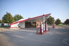 | Vickers Petroleum Service Station | 5.1 miles | 2019 |
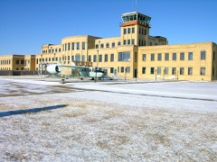 | Administration Building | 6.1 miles | 1990 |
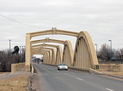 | John Mack Bridge | 8.0 miles | 1992 |
| National Archives record | The nomination case file for reference 14000832 in Record Group 79. |
| Sedgwick County | All 148 listed properties in this county. |