 Block
From the record
One of 10 National Register listings published here for Laurel County · listed in 2006 · category: Site.
Sources: the case file at the National Archives · the National Register database, National Park Service
Listed on the National Register of Historic Places in 2006.
One of 10 National Register listings published here for Laurel County · listed in 2006 · category: Site.
Sources: the case file at the National Archives · the National Register database, National Park Service
Regional context, not property-specific evidence. The federal wildfire occurrence database lists 282 fires within 5 miles of Wildcat Mountain Battlefield (Boundary Increase) between 1992 and 2020, burning about 9,566 acres in total. 2 started naturally. 98 were recorded as arson. Distance is straight-line from the map coordinates, so a fire counted here may appear on a neighbouring settlement's page as well.
| Reported cause | Fires |
|---|---|
| Arson/incendiarism | 98 |
| Debris and open burning | 96 |
| Missing data/not specified/undetermined | 60 |
| Recreation and ceremony | 17 |
| Railroad operations and maintenance | 6 |
| Natural | 2 |
| Misuse of fire by a minor | 1 |
| Equipment and vehicle use | 1 |
| Smoking | 1 |
The most recent of them, most recent first, with the day each was reported and the service that recorded it.
| Date | Cause | Size | Reported by | Name on the report |
|---|---|---|---|---|
| 7 September 2001 | Arson/incendiarism | under an acre | Kentucky Division of Forestry | not named |
| 6 September 2007 | Recreation and ceremony | 2.0 acres | Kentucky Division of Forestry | not named |
| 30 September 2007 | Debris and open burning | 8.0 acres | Kentucky Division of Forestry | not named |
| 29 September 2008 | Debris and open burning | 1.0 acres | Kentucky Division of Forestry | not named |
| 2 September 2009 | Recreation and ceremony | 1.0 acres | Kentucky Division of Forestry | not named |
| 19 September 1999 | Arson/incendiarism | 4.0 acres | Daniel Boone National Forest | CROMER RIDGE |
| 18 September 2007 | Railroad operations and maintenance | 1.0 acres | Kentucky Division of Forestry | not named |
| 18 September 2007 | Railroad operations and maintenance | 1.0 acres | Kentucky Division of Forestry | not named |
Regional context, not property-specific evidence. The National Weather Service names East Bernstadt, the town this property stands in, in 43 storm reports between 1997 and 2025: 35 thunderstorm wind, 3 hail, 3 flash flood, 1 tornado. No death or injury is recorded in these reports. Each account below is quoted exactly as the forecast office filed it, from the NOAA Storm Events Database, and each date opens the federal record of that event.
| When | Event | Place named | Harm | What the report says |
|---|---|---|---|---|
| March 2012 | Thunderstorm Wind | East Bernstadt | $50,000 | Multiple mobile homes were damaged on Little County Road. |
| April 2022 | Thunderstorm Wind | East Bernstadt | $40,000 | NWS Storm Survey and Emergency Manager report that the steeple at the First Baptist Church in East Bernstadt was blown off the roof. A peak wind gust of 60 to 65 mph was estimated due to the exposure of the steeple, and the lack of any other damage in the vicinity. |
| January 2008 | Thunderstorm Wind | East Bernstadt | $20,000 | A television tower was blown over by winds estimated at 69 mph. |
| January 2008 | Thunderstorm Wind | East Bernstadt | $20,000 | A television tower was blown over by wind gusts estimated at 63 mph. |
| June 2011 | Thunderstorm Wind | East Bernstadt | $7,000 | Several trees were blown down. |
| June 2011 | Thunderstorm Wind | East Bernstadt | $5,000 | Trees and power lines were blown down along Hwy 490 northwest of London. |
| December 1998 | Thunderstorm Wind | East Bernstadt | $5,000 | Trailer was blown off its foundation. |
| May 2011 | Thunderstorm Wind | East Bernstadt | $3,000 | Three large trees were blown down and across Hwy 1227. |
| July 2023 | Thunderstorm Wind | East Bernstadt | $1,000 | A tree and powerlines were blown down in East Bernstadt at KY-3434 near the intersection of Noelle Road. |
| April 2022 | Thunderstorm Wind | East Bernstadt | $1,000 | Trees were downed onto power lines along KY-490 in the 1800 block. Trees were also reported down on the railroad tracks in East Bernstadt. |
| July 2015 | Flash Flood | East Bernstadt | $1,000 | Six inches of water was flowing across the roadway at the intersection of Hwy 490 and Hwy 3094 at School Street. |
| May 2011 | Thunderstorm Wind | East Bernstadt | $1,000 | A few shingles were blown off a home and everything on the patio was blown about 100 yards into the woods. Wind speed was measured at 77 mph. |
| May 2011 | Thunderstorm Wind | East Bernstadt | $1,000 | A tree was blown down and across a road in East Bernstadt. |
| February 2009 | Thunderstorm Wind | East Bernstadt | $1,000 | One tree was blown down near Highway 30. |
| June 2025 | Thunderstorm Wind | East Bernstadt | - | A Laurel County deputy reported a downed tree along School Street in East Bernstadt. |
| April 2025 | Hail | East Bernstadt | - | A member of the public sent a report in through mPING of dime sized hail (0.75 inches) in East Berdstadt. |
| June 2023 | Thunderstorm Wind | East Bernstadt | - | A member of the public reported a tree blown down on Litton Town Road. |
| May 2023 | Thunderstorm Wind | East Bernstadt | - | County dispatch reported tree blown down in East Bernstadt. |
| May 2023 | Flash Flood | East Bernstadt | - | Water was observed flowing across the intersection of Highways 3094 and 490. |
| May 2022 | Thunderstorm Wind | East Bernstadt | - | Trees were blown down and onto Highway 490 in East Bernstadt. |
| June 2021 | Thunderstorm Wind | East Bernstadt | - | Multiple trees were reported down along Highway 490 in the vicinity of East Bernstadt. |
| December 2021 | Thunderstorm Wind | East Bernstadt | - | A tree was reported to have been blown down in the East Bernstadt community. |
| June 2019 | Thunderstorm Wind | East Bernstadt | - | Dispatch reported trees blown down in East Bernstadt. |
| May 2018 | Thunderstorm Wind | East Bernstadt | - | Dispatch relayed a report of a large tree blown down on Kentucky Highway 490 near East Bernstadt. |
| May 2016 | Thunderstorm Wind | East Bernstadt | - | The Kentucky State Police post in London along with trained spotters reported a swath of thunderstorm wind damage, extending from East Bernstadt to south of London. Multiple trees were blown down, causing various property damage. Additionally, several business signs were damaged in London. |
| July 2015 | Thunderstorm Wind | East Bernstadt | - | Multiple trees were blown down near East Bernstadt. |
| July 2015 | Thunderstorm Wind | East Bernstadt | - | A tree was blown down and across Hwy 490. |
| May 2014 | Thunderstorm Wind | East Bernstadt | - | Trees and power lines were blown down. |
| December 2013 | Thunderstorm Wind | East Bernstadt | - | Several trees were blown down on Hwy 25 and on Hazel Patch Road. |
| June 2013 | Thunderstorm Wind | East Bernstadt | - | A tree was blown down and onto a house. A second tree was blown down and onto Hwy 490. |
| April 2013 | Flood | East Bernstadt | - | A bridge on Victory Road was inundated by high water. |
| September 2012 | Thunderstorm Wind | East Bernstadt | - | A tree was blown down on Hwy 490. |
| April 2011 | Thunderstorm Wind | East Bernstadt | - | A trampoline was blown into some power lines. |
| May 2011 | Thunderstorm Wind | East Bernstadt | - | A 61 mph wind gust was measured. |
| March 2011 | Thunderstorm Wind | East Bernstadt | - | The wind blew down two to three trees. |
| November 2005 | Thunderstorm Wind | East Bernstadt | - | Trees down on East Pittsburgh Church Road. |
| June 2004 | Flash Flood | East Bernstadt | - | Highway 30 was flooded with about 18 inches of water for about 100 yards. Highway 25 and Highway 1228 were also flooded. |
| November 2002 | Thunderstorm Wind | East Bernstadt | - | Several trees were down. |
| April 2002 | Hail | East Bernstadt | - | An estimated 50 knot wind occurred along with one inch diameter hail. |
| July 2000 | Thunderstorm Wind | East Bernstadt | - | Several trees down. |
| January 1999 | Thunderstorm Wind | East Bernstadt | - | Trees down. |
| March 1997 | Hail | East Bernstadt | - | no account filed |
| March 1997 | Tornado (F0) | East Bernstadt | - | no account filed |
No historic map-sheet match is published for this property yet. That does not mean no map exists. This record needs a coordinate-quality review before it can be joined to a sheet boundary. Browse the county's mapped places while that work is pending.
Other National Register properties close enough to walk or drive between, ordered by distance from this one. Both positions come from the same geocoding pass that matched these properties to their map sheets.
| Photograph | Property | Distance | Listed |
|---|---|---|---|
| Wildcat Battlefield Site | 0.9 miles | 1979 | |
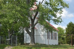 | First Evangelical Reformed Church | 6.5 miles | 1980 |
| National Archives record | The nomination case file for reference 06000808 in Record Group 79. |
| Laurel County | All 10 listed properties in this county. |