 Block
From the record
One of 10 National Register listings published here for Laurel County · listed in 1979 · category: Site.
Sources: the case file at the National Archives · the National Register database, National Park Service
Listed on the National Register of Historic Places in 1979.
One of 10 National Register listings published here for Laurel County · listed in 1979 · category: Site.
Sources: the case file at the National Archives · the National Register database, National Park Service
Regional context, not property-specific evidence. The federal wildfire occurrence database lists 285 fires within 5 miles of Wildcat Battlefield Site between 1992 and 2020, burning about 9,276 acres in total. 2 started naturally. 98 were recorded as arson. Distance is straight-line from the map coordinates, so a fire counted here may appear on a neighbouring settlement's page as well.
| Reported cause | Fires |
|---|---|
| Debris and open burning | 100 |
| Arson/incendiarism | 98 |
| Missing data/not specified/undetermined | 62 |
| Recreation and ceremony | 14 |
| Railroad operations and maintenance | 6 |
| Natural | 2 |
| Misuse of fire by a minor | 1 |
| Equipment and vehicle use | 1 |
| Smoking | 1 |
The most recent of them, most recent first, with the day each was reported and the service that recorded it.
| Date | Cause | Size | Reported by | Name on the report |
|---|---|---|---|---|
| 7 September 2001 | Arson/incendiarism | under an acre | Kentucky Division of Forestry | not named |
| 6 September 2007 | Recreation and ceremony | 2.0 acres | Kentucky Division of Forestry | not named |
| 30 September 2007 | Debris and open burning | 8.0 acres | Kentucky Division of Forestry | not named |
| 29 September 2008 | Debris and open burning | 1.0 acres | Kentucky Division of Forestry | not named |
| 2 September 2009 | Recreation and ceremony | 1.0 acres | Kentucky Division of Forestry | not named |
| 19 September 1999 | Arson/incendiarism | 4.0 acres | Daniel Boone National Forest | CROMER RIDGE |
| 19 September 1999 | Arson/incendiarism | 35 acres | Kentucky Division of Forestry | not named |
| 18 September 2007 | Railroad operations and maintenance | 1.0 acres | Kentucky Division of Forestry | not named |
Regional context, not property-specific evidence. The National Weather Service names London, the town this property stands in, in 188 storm reports between 1993 and 2025: 100 thunderstorm wind, 48 hail, 27 flash flood, 4 lightning. The reports record 11 injuries. Each account below is quoted exactly as the forecast office filed it, from the NOAA Storm Events Database, and each date opens the federal record of that event.
| When | Event | Place named | Harm | What the report says |
|---|---|---|---|---|
| June 2001 | Tornado (F2) | London | 10 hurt, $17,140,000 | A strong F2 tornado with wind estimates between 135 and 155 miles per hour ripped through downtown London during the evening hours. The Carnaby Square shopping center was hard hit. The tornado was reported by eye witnesses to have been nearly stationary in the parking lot for nearly 4 minutes. During this time several automobiles including a large moving van were overtured. A 20 by 30 foot chunk of 4 inch thick blacktop from the parking lot was torn up and thrown approximately 100 feet. Merchandise from one of the stores was later found 25 miles to the east. The tornado lifted before crossing U.S. Highway 25. The tornado touched down again along Bellinger Street between 6:15 and 6:20 pm where several homes received major damage. One duplex lost its entire roof as a mother and her two sons took shelter on the second floor. A mobile home used for storage was demolished. One block over on Morgan Street several brick and framed homes lost their entire roofs. A framed home placed on a block foundation was blown 15 feet away from the foundation. The storm lifted as if approached the Rolling Acres Subdivision. Witnesses reported seeing two funnel clouds at this time as the storm continued moving east. Damage was confined to large trees and some shingle damage on roofs of homes. The storm again dropped a tornado as it approached a ball park just northwest of the intersection of Kentucky Highway 192 and 80. Three of the four teams in the park took refuge in the concession stand and the fourth team remained in the dugout where parents covered the children while laying on the ground. One mid sized truck was tossed from the parking lot approximately 150 feet. Fencing from both ball diamonds was blown away. The last major damage occurred at a mobile home sales lot near the intersection of Kentucky Highway 192 and the Daniel Boone Parkway. Eight mobile homes weighing 8 to 12 tons were totaled.Emergency management officials reported that there were 10 minor injuries with the most serious being a broken arm. Eighteen residences were destroyed, 21 received major damage while 84 received minor damage. Twenty-six businesses suffered major damage. One church received major damage with another receiving minor damage. Thirty vehicles were destroyed and three 18 wheel tractor trailers were overturned. |
| July 2002 | Lightning | London | 1 hurt | One woman was struck by lightning. |
| May 2024 | Lightning | London | $200,000 | Video showed lightning striking a business in downtown London and starting a fire. The structure was reported a total loss. |
| April 2007 | Tornado (EF1) | London | $150,000 | An EF1 tornado with a path length of 1.8 miles and a path width of 50 yards destroyed a pole barn, uprooted large hardwood trees, pushed a well tied down mobile home off its foundation and blew a roof off of a store. |
| May 2024 | Thunderstorm Wind | London | $80,000 | A tree fell onto a residence on Camelot Place in the city of London. |
| July 2008 | Thunderstorm Wind | London | $50,000 | Numerous trees were blown down by thunderstorm wind gusts, mainly in the eastern and southeastern sections of the county. |
| April 2007 | Thunderstorm Wind | London | $50,000 | Stuctural damage, with trees and power lines down. Damage was in western, southern, and eastern portions of county. |
| August 2003 | Flash Flood | London | $50,000 | Flowing water moved cars on Seven School Road. There was one and a half feet of water flowing across Mill Street, between Fifth and Seventh Streets. One foot of water was in a basement and around a home on Valley Lane off of Highway 1006. |
| July 2012 | Thunderstorm Wind | London | $40,000 | The roof was blown off a tobacco house and a greenhouse was damaged in London. |
| April 2007 | Thunderstorm Wind | London | $35,000 | Barn totally demolished, houses slightly damaged. |
| May 2025 | Thunderstorm Wind | London | $30,000 | A report came in of a roof being peeled off a business, falling onto multiple adjacent vehicles which sustained unspecified damage. |
| April 2011 | Thunderstorm Wind | London | $30,000 | A part of a building was blown off. |
| May 2024 | Thunderstorm Wind | London | $20,000 | The Laurel County EM reported damage to at least one building at the Flea Land flea market in London. Photos shared showed the roof missing off one building. |
| September 2003 | Flash Flood | London | $20,000 | The following roads were closed due to flash flooding: East Fourth Street at Tobacco Road, Tobacco Road from Green Street to Roosevelt Street, Middleground Way, Commercial Drive, and Spring Street. Water was reported to be as high as the fender wells on cars. One home was flooded along with several businesses. |
| May 2002 | Flash Flood | London | $20,000 | Flash flooding resulted in a road being damaged in London. Several roads were closed due to flowing water, and high waters caused a trailer to flood. |
| April 2011 | Thunderstorm Wind | London | $15,000 | There were trees and power lines down on Parker road. There was a possible funnel cloud in the area. |
| April 2011 | Thunderstorm Wind | London | $15,000 | There were power lines and trees down on County Farm Road 1 mile west of London. |
| June 2008 | Thunderstorm Wind | London | $15,000 | Several 1 foot diameter trees were blown down along Good Branch Road and across a driveway. Branches were also torn off several trees. |
| June 2021 | Thunderstorm Wind | London | $10,000 | Numerous trees were reported being blown down in the city of London, taking down power lines with them. |
| June 2004 | Thunderstorm Wind | London | $10,000 | A tree was reported to have fallen across a trailer on Delbert Hodge Road by North Laurel High School. |
| March 2002 | Flash Flood | London | $10,000 | 24 Hour rainfall amounts between four and five inches, caused several roads to be flooded. |
| July 2001 | Flash Flood | London | $10,000 | Heavy rains caused flooding to numerous homes and the nursing home in town was also flooded. |
| May 1998 | Hail | London | $10,000 | no account filed |
| May 2025 | Thunderstorm Wind | London | $8,000 | Multiple photoes show a large tree snapped and split three ways, blocking the intersection of Whitley Street and Jody Street in London. The tree also caused a power pole to snap when it came down, resulting in downed power lines. |
| June 2001 | Thunderstorm Wind | London | $8,000 | Thunderstorm winds blew windows out of a Days Inn Motel. A barn was blown down on Kentucky Highway 192 West along with several trees being uprooted. |
| July 2008 | Thunderstorm Wind | London | $7,000 | Several trees were blown down by thunderstorm wind gusts. |
| July 2013 | Lightning | London | $5,000 | Lightning struck a tree on Little Pittsburg Road, knocking it over onto a power pole and causing the power to go out. |
| June 2011 | Thunderstorm Wind | London | $5,000 | Trees were blown down along Hatcher Rd near London. One tree fell on a mobile home. |
| April 2011 | Thunderstorm Wind | London | $5,000 | A tree landed on a vehicle on Old Whitley Road in London after being blown down by thunderstorm wind gusts. |
| August 2006 | Lightning | London | $5,000 | Lightning struck the China Town restaurant and started a fire. |
| July 2001 | Flash Flood | London | $5,000 | Water was flowing over West 192 resulting in the flooding of the Esquire Estates sub-division. Water was reported in some homes. Water as deep as car headlights was also reported along Highways 30 and 490. |
| April 2011 | Thunderstorm Wind | London | $3,000 | Power lines were blown down at the intersection of KY 1006 and KY 363 in London. |
| April 2011 | Thunderstorm Wind | London | $3,000 | There were trees on power lines along highway 1006 and 363. |
| June 2011 | Thunderstorm Wind | London | $3,000 | Trees were blown down on Old Way Rd. |
| June 2010 | Thunderstorm Wind | London | $3,000 | Trees were blown down on Amelia Drive in London. |
| June 2010 | Thunderstorm Wind | London | $3,000 | Several large limbs were broken out of trees in the Sublimity Springs subdivision. |
| July 2008 | Thunderstorm Wind | London | $3,000 | Two trees and three large branches were blown down in the southeast portion of London along Highway 363. |
| April 2007 | Thunderstorm Wind | London | $3,000 | Road sign broken. Two trees down on Parker Road. |
| May 2002 | Thunderstorm Wind | London | $3,000 | Several trees were downed by strong winds across the southern half of Laurel County. |
| January 1997 | Thunderstorm Wind | London | $3,000 | no account filed |
| August 2011 | Thunderstorm Wind | London | $2,000 | Tree limbs 7 inches in diameter were blown down. |
| June 2008 | Thunderstorm Wind | London | $2,000 | Two trees were blown down near the intersection of I-75 and Highway 192. |
| June 2001 | Thunderstorm Wind | London | $2,000 | Strong thunderstorm winds blew a business sign onto two parked cars. |
| December 2000 | Flash Flood | London | $2,000 | House flooded by creek along KY Hwy 1004. One side of highway closed. |
| October 2004 | Thunderstorm Wind | London | $2,000 | no account filed |
| July 2021 | Flash Flood | London | $1,000 | Laurel county dispatch reported that East 4th Street (Highway 80) in London was closed in the vicinity of Tobacco Road due to flash flooding. |
| May 2016 | Flood | London | $1,000 | Several roads in and around London were covered by water of unknown depth. |
| July 2015 | Flash Flood | London | $1,000 | Fifth Street at Tobacco Road was closed due to flooding. |
| July 2015 | Flash Flood | London | $1,000 | Six inches of water was observed flowing across Hwy 80 East. Four to five inches of water was seen flowing across Tobacco Road. |
| May 2011 | Thunderstorm Wind | London | $1,000 | A tree was blown down outside of the jail in London. |
| February 2009 | Thunderstorm Wind | London | $1,000 | A tree was blown down. This report was received from someone at the London Sentinel Echo newspaper office. |
| January 2006 | Thunderstorm Wind | London | $1,000 | Tin roof torn off trailer. |
| April 2005 | Thunderstorm Wind | London | $1,000 | Power pole blown down on Highway 192. |
| August 2005 | Thunderstorm Wind | London | $1,000 | Trees and power lines down along Highway 1006. |
| August 2016 | Thunderstorm Wind | London | $10 | A citizen reported via social media that two trees were blown down southwest of London. |
| May 2025 | Thunderstorm Wind | London | - | A spotter in southeast London noted that trees were downed along Barrett Road as storms moved through. |
| June 2025 | Thunderstorm Wind | London | - | A tree was reported down at intersection of Mill and 5th streets in downtown London. |
| May 2024 | Thunderstorm Wind | London | - | A large tree was blown down in front of 266 Waterworks Road in London. |
| May 2024 | Thunderstorm Wind | London | - | A tree was reported down on W. 7th Street, near N. Long Road, in downtown London. |
| May 2023 | Flash Flood | London | - | Water was seen flowing over Tobacco Road in London, leading to the closure of a lane of the road. |
No historic map-sheet match is published for this property yet. That does not mean no map exists. This record needs a coordinate-quality review before it can be joined to a sheet boundary. Browse the county's mapped places while that work is pending.
Other National Register properties close enough to walk or drive between, ordered by distance from this one. Both positions come from the same geocoding pass that matched these properties to their map sheets.
| Photograph | Property | Distance | Listed |
|---|---|---|---|
| Wildcat Mountain Battlefield (Boundary Increase) | 0.9 miles | 2006 | |
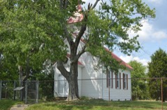 | First Evangelical Reformed Church | 7.3 miles | 1980 |
| National Archives record | The nomination case file for reference 79001018 in Record Group 79. |
| Laurel County | All 10 listed properties in this county. |