 Block
From the record
One of 15 National Register listings published here for Kandiyohi County · listed in 1986 · category: Building.
Sources: the case file at the National Archives · the National Register database, National Park Service
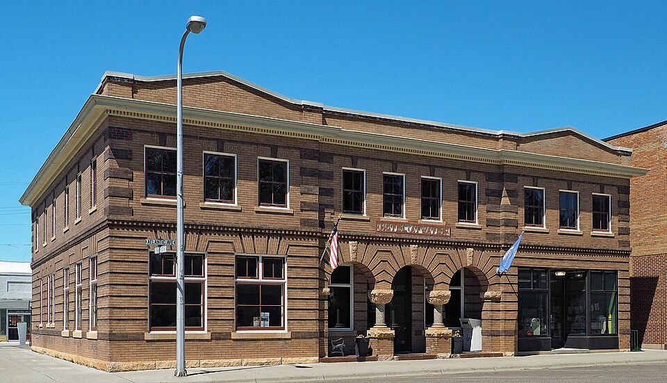
Listed on the National Register of Historic Places in 1986.
One of 15 National Register listings published here for Kandiyohi County · listed in 1986 · category: Building.
Sources: the case file at the National Archives · the National Register database, National Park Service
Regional context, not property-specific evidence. The federal wildfire occurrence database lists 1 fire within 5 miles of Hotel Atwater in 2013, burning about 28 acres in total. None started naturally. None was recorded as arson. Distance is straight-line from the map coordinates, so a fire counted here may appear on a neighbouring settlement's page as well.
| Reported cause | Fires |
|---|---|
| Debris and open burning | 1 |
The most recent of them, most recent first, with the day each was reported and the service that recorded it.
| Date | Cause | Size | Reported by | Name on the report |
|---|---|---|---|---|
| 3 May 2013 | Debris and open burning | 28 acres | Litchfield Wetland Management District | UNCLE MATT WF |
Regional context, not property-specific evidence. The federal mineral resources record lists 2 workings within 5 miles of Hotel Atwater: 2 producers. All of them still produce. What was taken out: Sand and Gravel, Construction. Distance is straight-line from the map coordinates, so a quarry counted here may appear on a neighbouring settlement's page as well.
| Where | Site | Commodity | Status | Recorded |
|---|---|---|---|---|
| Atwater Pit and Mill | Sand and Gravel, Construction | Producer | ||
| Hall Pit | Sand and Gravel, Construction | Producer |
Regional context, not property-specific evidence. The National Weather Service names Atwater, the town this property stands in, in 30 storm reports between 1996 and 2025: 12 hail, 11 thunderstorm wind, 6 tornado, 1 funnel cloud. No death or injury is recorded in these reports. Each account below is quoted exactly as the forecast office filed it, from the NOAA Storm Events Database, and each date opens the federal record of that event.
| When | Event | Place named | Harm | What the report says |
|---|---|---|---|---|
| August 2018 | Tornado (EF0) | Atwater | $100,000 | A NWS storm survey indicated an EF0 Tornado began near Atwater and tracked east for 1.6 miles along Highway 12, and entered Meeker County. Multiple trees and power lines were blown down in the city of Atwater. Some of the trees landed on houses and caused structural damage. |
| July 2023 | Thunderstorm Wind | Atwater | $15,000 | Decaying thunderstorm caused a large tree to fall on an unoccupied vehicle in the city of Atwater. The photo was relayed by the emergency manager, and time was estimated from radar. |
| June 2025 | Thunderstorm Wind | Atwater | - | Multiple downed trees on a property west of Lake Elizabeth. |
| August 2024 | Thunderstorm Wind | Atwater | - | Dozens of trees were uprooted or broken across Atwater. A damage survey determined the damage was due to a downburst, with a wide area of damaged trees scattered across the west and south sides of town. A few trees blocked roads or landed on houses, garages, and vehicles. Most trees were blown from the northeast to the southwest. |
| August 2024 | Hail | Atwater | - | Hail measurement provided via social media. |
| August 2024 | Thunderstorm Wind | Atwater | - | Several large trees down throughout and just south of Atwater. |
| August 2020 | Tornado (EF0) | Atwater | - | An NWS Survey found an EF-0 tornado began over a peninsula of the northern portions of Diamond Lake. The tornado tracked northeast to the Kandiyohi/Meeker County line, near 340th Street and 210th Street Southeast, and did move into Meeker County.||Video from two storm chasers and one law enforcement officer showed this tornado. A damage survey also used two drones to determine the exact damage path. The tornado moved mostly over corn and bean fields, but did hit numerous trees that were snapped or uprooted when it was in Kandiyohi County. |
| June 2017 | Thunderstorm Wind | Atwater | - | Large branches were broken. |
| September 2014 | Thunderstorm Wind | Atwater | - | A large pear tree was uprooted. |
| September 2014 | Thunderstorm Wind | Atwater | - | A few trees were blown down near Diamond Lake. |
| July 2011 | Tornado (EF0) | Atwater | - | There were several reports of a brief tornado from Skywarn Spotters and the public in a field along 310th Street, approximately 5 miles north-northeast of Atwater, Minnesota. An EF-0 tornado was confirmed the next day by a National Weather Service Service Team near the Kandiyohi/Meeker County line.||One detailed account indicated the condensation of the tornado reached the ground for about 20 seconds before the tornado dissipated. This occurred in a corn field.||Based on radar and information from the survey, winds were around 65 mph, with a path length near an 1/8 of a mile, and a width of 10 yards. |
| June 2008 | Hail | Atwater | - | Occurred at intersection of County Road 2 and 28. |
| June 2005 | Thunderstorm Wind | Atwater | - | A power line and tree branches were downed. |
| September 2005 | Thunderstorm Wind | Atwater | - | Trees were downed onto a home just west of Summit Lake on 1st Avenue E. Scattered trees were also downed in the northeast portion of the county. |
| September 2005 | Thunderstorm Wind | Atwater | - | Trees and power lines were downed. |
| September 2005 | Tornado (F0) | Atwater | - | Brief touchdown near the intersection of County Roads 23 and 2. No damage. |
| June 2004 | Hail | Atwater | - | Dime to nickel sized hail fell near Big Kandi Lake. |
| June 2003 | Tornado (F0) | Atwater | - | This was the sixth tornado on this day to touch down in Kandiyohi County, although the other five tornadoes were from a different supercell. This tornado tore across open fields then moved into Meeker County at 1916 CST. A few trees were felled. |
| May 2000 | Tornado (F0) | Atwater | - | Power lines down. |
| May 2024 | Hail | Atwater | - | no account filed |
| August 2024 | Hail | Atwater | - | no account filed |
| May 2022 | Hail | Atwater | - | no account filed |
| May 2008 | Hail | Atwater | - | no account filed |
| September 2005 | Hail | Atwater | - | no account filed |
| September 2005 | Funnel Cloud | Atwater | - | no account filed |
| May 2002 | Hail | Atwater | - | no account filed |
| May 2002 | Hail | Atwater | - | no account filed |
| June 2001 | Hail | Atwater | - | no account filed |
| June 1999 | Hail | Atwater | - | no account filed |
| June 1996 | Thunderstorm Wind | Atwater | - | no account filed |
No historic map-sheet match is published for this property yet. That does not mean no map exists. This record needs a coordinate-quality review before it can be joined to a sheet boundary. Browse the county's mapped places while that work is pending.
Other National Register properties close enough to walk or drive between, ordered by distance from this one. Both positions come from the same geocoding pass that matched these properties to their map sheets.
| Photograph | Property | Distance | Listed |
|---|---|---|---|
| John Bosch Farmstead | 6.8 miles | 1987 | |
| Broman, Andreas, Johanna, Anna and Frank E., Farmstead | 7.5 miles | 1991 |
| National Archives record | The nomination case file for reference 86001330 in Record Group 79. |
| Kandiyohi County | All 15 listed properties in this county. |