 Block
From the record
13 National Register listings published here.
Sources: the National Register database, National Park Service
30 topographic sheets cover 17 settlements here, and 13 properties are on the National Register of Historic Places.
13 National Register listings published here.
Sources: the National Register database, National Park Service
Every property in this county listed on the National Register of Historic Places, with the year it was listed and the federal nomination document.
| Photograph | Property | Type | Listed | Reference |
|---|---|---|---|---|
| Adrian State Bank | building | 1980 | 80002093 | |
 | Church of St. Adrian-Catholic | building | 1980 | 80002094 |
| Church of St. Kilian (Catholic) | building | 1998 | 97001425 | |
 | Citizens' National Bank | building | 1982 | 82002990 |
 | George D. Dayton House | building | 2003 | 03001336 |
 | Hotel Thompson | building | 1984 | 84001625 |
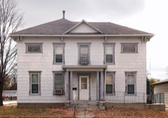 | Dr. E. A. Kilbride Clinic | building | 1977 | 77000760 |
| Nobles County War Memorial Building | building | 2017 | 100001024 | |
| Siemer Silo and Barn | building | 1980 | 80002095 | |
| Sioux City and St. Paul Railroad Section House | building | 1980 | 80002096 | |
 | Slade Hotel | building | 1975 | 75000999 |
| Worthington Armory and Community Building | building | 2017 | 100001844 | |
| Worthington Band Shell | structure | 2015 | 15000439 |
Every wildfire the federal occurrence database records inside this county: 1 of them, burning about 20 acres. None started naturally and none was recorded as arson. Each settlement page carries the fires within five miles of it.
| Reported cause | Fires |
|---|---|
| Missing data/not specified/undetermined | 1 |
The five largest, by the area the report gives. None of them was recorded as arson.
| Date | Cause | Size | Reported by | Name on the report |
|---|---|---|---|---|
| 18 December 2020 | Missing data/not specified/undetermined | 20 acres | Minnesota Department of Natural Resources | not named |
Every settlement page carries the fires within five miles of it - see the settlement index below.
The NOAA Storm Events Database holds 451 reports for this county, causing no deaths, 2 injuries and about $38,456,250 in recorded property damage. Each settlement page carries the reports that name it.
| Kind of event | Reports |
|---|---|
| Hail | 217 |
| Thunderstorm Wind | 141 |
| Tornado | 44 |
| Flash Flood | 24 |
| Heavy Rain | 9 |
| Flood | 8 |
| Funnel Cloud | 5 |
| Lightning | 3 |
The most serious of them, by death, then injury, then recorded damage. The accounts are quoted exactly as the forecast office filed them.
| When | Event | Place named | Harm | What the report says |
|---|---|---|---|---|
| April 1986 | Tornado (F2) | not stated | 2 hurt, $2,500,000 | no account filed |
| June 1992 | Tornado (F5) | not stated | $25,000,000 | no account filed |
| June 2024 | Flood | Ellsworth | $3,600,000 | Rainfall amounts across Nobles County from June 20-22 ranged from 4 to 10 inches. This rainfall resulted in widespread overland flooding across the county. Okabena Lake in Worthington also overflowed its banks, flooding the downtown area and residential properties surrounding the lake. ||During peak flooding, there were 3 swift water rescues and a reported 6 stalled vehicles. Three apartment buildings and one home in Worthington needed to be evacuated, impacting 35 individuals. County-wide, 350 individuals reported flood damage. Of these, 5 residences were declared destroyed, 55 with major damage, and another 250 with minor damage. ||There were 150 locations that reported flood damage to roads, culverts, and bridges. There were also 40 drainage ditches with major damages. Among numerous township, county, and state roads that were closed and damaged, Interstate 90 was also closed with water over the roadbed in many locations for up to 3 days. Seven of eleven municipalities declared flood damages. The Adrian School District reported water damage to 2 school facilities and there also were collapsed sewer pipes within the city. Preliminary damage assessments estimate loss to public infrastructure to be 3.6 million dollars. |
| August 2004 | Thunderstorm Wind | Adrian | $1,000,000 | Thunderstorm winds destroyed a grain elevator and several grain bins. The winds also damaged roofs and siding on several homes and businesses. There was widespread tree damage including several trees blown down. Homes, businesses, and vehicles sustained additional damage from falling or flying tree debris, and debris blocked several roads. Power lines were blown down, resulting in power outages. The winds caused severe crop damage in the area, but the amount of crop damage could not be determined. |
| August 2004 | Thunderstorm Wind | Worthington | $1,000,000 | Thunderstorm winds blew parts of the roofs off a junior high school building and an apartment building, and overturned a semi truck. The winds caused widespread tree damage, including several large trees uprooted or blown down. Tree debris blocked several roads, and made the golf course at the country club unusable. Power lines were blown down and other lines were knocked down by falling tree debris, causing power outages. Tree debris also damaged several vehicles and buildings. At least one garage was destroyed by the winds. Several signs, including large billboards, were blown down. The winds damaged crops, especially corn, but the amount of crop damage could not be determined. |
| August 2017 | Tornado (EF1) | Rushmore | $500,000 | EF-1 tornado hit a hog confinement building before the storm crossed Interstate 90. 20 to 30 hogs were killed. |
| April 2004 | Tornado (F1) | Adrian | $500,000 | A tornado destroyed a barn and blew the walls of a garage off its foundation. The garage was attached to a house which received no apparent damage. |
| August 1994 | Tornado (F1) | Worthington | $500,000 | Several buildings on two farmsteads were destroyed. A number of hogs were killed and trees and power lines were blown down. |
| June 1996 | Hail | Adrian | $500,000 | no account filed |
| March 1998 | Tornado (F2) | Lismore | $400,000 | no account filed |
| March 2019 | Flood | Ellsworth | $316,000 | Flooding resulted in extensive damage to public infrastructure including numerous county and township roads, culverts, and some bridges. The property damage costs include estimates for public property losses. |
| July 1995 | Thunderstorm Wind | Worthington | $300,000 | Thunderstorm winds of unknown speed caused widespread tree damage, blew down a 50 thousand bushel steel grain bin, destroyed a barn and a hog building, and blew over two tractor-semitrailers. The winds also caused undetermined crop damage. |
| May 1977 | Tornado (F2) | not stated | $250,000 | no account filed |
| May 1956 | Tornado (F2) | not stated | $250,000 | no account filed |
| May 2004 | Thunderstorm Wind | Lismore | $200,000 | Thunderstorm winds destroyed two hog barns and a feed mill, and damaged a grain bin. One thousand hogs died of suffocation as a result of the damage. The owner's house on the other side of a nearby road was undamaged. |
| April 2002 | Thunderstorm Wind | Adrian | $200,000 | Thunderstorm winds caused tree damage, including at least one large tree blown down onto part of a house. The winds also blew down an Interstate sign. |
| March 1998 | Tornado (F2) | St Killian | $200,000 | no account filed |
| July 2000 | Tornado (F2) | Adrian | $150,000 | A tornado damaged buildings, vehicles, and trees on a farm. The tornado destroyed the west side of the house, blew three grain bins away and wrapped them around trees. The tornado also blew the top of a barn off, killing at least 4 calves inside. |
| August 2003 | Thunderstorm Wind | Brewster | $100,000 | Thunderstorm winds caused widespread tree damage. Several houses were damaged by falling trees and wind blown tree debris. A roof was blown off a home northwest of Brewster. |
| April 2002 | Thunderstorm Wind | Dundee | $100,000 | Thunderstorm winds blew the roof off a building, severely buckled an elevator bin, and caused tree damage. |
| June 2001 | Thunderstorm Wind | Ellsworth | $100,000 | Thunderstorm winds caused severe damage to at least two farms. Barns at both farms were completely destroyed, as were two vehicles in one of the barns. There was also damage to houses, equipment, and trees on the farms. |
| July 1998 | Thunderstorm Wind | Ellsworth | $100,000 | no account filed |
| March 1998 | Tornado (F1) | St Killian | $100,000 | no account filed |
| June 2014 | Flood | Leota | $50,000 | Persistent moderate to heavy rain caused flooding of fields and other lowlands, including several roads, homes, and businesses. This flooding lasted for two days, and was aggravated locally by additional storms during that time. Some roads were damaged or washed out. |
| May 2004 | Thunderstorm Wind | Adrian | $50,000 | Thunderstorm winds caused widespread tree damage. Trees as large as a foot and a half in diameter were blown down, along with numerous limbs and branches. Several roads were blocked by tree debris. The winds also caused damage to power lines. |
| August 2004 | Thunderstorm Wind | Worthington | $50,000 | Thunderstorm winds caused tree damage, including several trees blown down. One tree fell through the roof and top two floors of a home. |
| August 2004 | Thunderstorm Wind | Reading | $50,000 | Thunderstorm winds destroyed at least two silos, blowing one of them halfway across a field. The winds damaged and moved another silo, larger than the others, off its foundation. The winds also caused tree damage, including several trees blown down. Tree debris broke a window in a mobile home. The winds damaged crops, especially corn, but the amount of crop damage could not be determined. |
| March 1998 | Tornado (F0) | Wilmont | $50,000 | no account filed |
| June 1996 | Thunderstorm Wind | Adrian | $50,000 | no account filed |
| October 1996 | Tornado (F0) | Round Lake | $50,000 | no account filed |
| July 1979 | Tornado (F0) | not stated | $25,000 | no account filed |
| July 1966 | Tornado (F1) | not stated | $25,000 | no account filed |
| August 1964 | Tornado (F1) | not stated | $25,000 | no account filed |
| June 2008 | Tornado (EF1) | Pfingsten | $20,000 | A tornado damaged the top of a silo, blew the roof off a shed, and caused tree damage at a farmstead, before crossing into Murray County. |
| May 2004 | Thunderstorm Wind | Ellsworth | $20,000 | Thunderstorm winds destroyed a small building. |
| August 2023 | Tornado (EF0) | Kinbrae | $10,000 | A tornado touched down around 1 mile west-southwest of Kinbrae, just south of 120th Street to the east of Town Avenue. The tornado traveled northeast and crossed the road, where the tornado passed through a farmstead and removed a few metal panels from a farm outbuilding. After the tornado left a path across a corn field while it moved another one-half mile northeast, the tornado impacted a tree line and uprooted a large pine tree. The tornado continued across open fields with a slightly more eastward turn, then lifted near the intersection of 110th Street and Ulrich Avenue. The path was captured by a local resident with a drone, with an average path width of 40 yards. The tornado was rated an EF-0 with a maximum wind speed of 80 mph. Property damage costs are a rough estimate. |
| August 2020 | Tornado (EF0) | Reading | $10,000 | A brief touchdown occurred in a corn field, with an observed twisting to the crops. The tornado travelled a very short distance to the northeast and lifted as it moved near a small hog house. The hog house was slightly displaced from its foundation. Property damage costs are rough estimates. |
| August 2019 | Tornado (EF0) | Reading | $10,000 | A brief tornado spun up a mile and a half northwest of Reading, uprooting a tree and taking down several other branches. While most of the damage along the path toward the east-northeast was to trees and crops, one house had some minor damage with removal of a section of roofing material. The average path width was 40 yards. |
| April 2018 | Thunderstorm Wind | Wilmont | $10,000 | Damage to machine shed. Piece of farm equipment was pushed into a power pole. |
| May 2010 | Thunderstorm Wind | Wilmont | $10,000 | Thunderstorm winds caused widespread tree damage, including large limbs blown down. The winds also damaged grain bins, siding and gutters on a home, and blew parts of the roofs off 2 hog barns. |
| July 2010 | Thunderstorm Wind | Worthington | $10,000 | Thunderstorm winds blew a semi off Interstate 90, and also caused tree damage, including several trees blown down. |
| September 1995 | Hail | Brewster | $10,000 | Hail damaged a few vehicles. |
| March 1998 | Tornado (F0) | Leota | $10,000 | no account filed |
| August 2021 | Thunderstorm Wind | Adrian | $5,000 | Large trees were leveled by thunderstorm wind gusts across southern portions of Adrian. Property damage costs are a rough estimate. |
| June 2020 | Flash Flood | Worthington | $5,000 | One vehicle became stalled in high water, with six reports of street flooding in the city. Property damage costs are rough estimates. |
| July 2010 | Thunderstorm Wind | Rushmore | $5,000 | Thunderstorm winds blew the roof off a barn and caused tree damage. |
| July 2010 | Thunderstorm Wind | Adrian | $5,000 | Thunderstorm winds destroyed a storage shed and caused tree damage, including several large trees and numerous branches blown down. The winds were accompanied by small hail. |
| May 2003 | Lightning | Worthington | $5,000 | Lightning struck a large tree, destroying the tree. The lightning also damaged appliances in at least two homes, and caused a power outage over a small area. |
| April 2001 | Thunderstorm Wind | Adrian | $5,000 | no account filed |
| October 1982 | Tornado (F0) | not stated | $2,500 | no account filed |
| May 1975 | Tornado (F0) | not stated | $2,500 | no account filed |
| May 1968 | Tornado (F1) | not stated | $2,500 | no account filed |
| July 1966 | Tornado (F1) | not stated | $2,500 | no account filed |
| July 2004 | Tornado (F1) | Adrian | $2,000 | A tornado damaged trees and destroyed outbuildings. |
| July 2001 | Lightning | Worthington | $2,000 | Lightning struck and split a large tree. Most of the tree fell and damaged siding on a house, but just missed a parked car. |
| October 2020 | Thunderstorm Wind | Round Lake | $1,000 | Several larger limbs were taken off trees by thunderstorm winds. Property damage costs are rough estimates. |
| April 1955 | Tornado (F1) | not stated | $250 | no account filed |
| April 2025 | Tornado (EFU) | (Otg)Worthington Arp | - | A brief landspout tornado was witnessed in an open field. From video evidence, the tornado touched down around 3 miles west-southwest of Brewster, just east of Sundberg Avenue north of 220th Street, and tracked to the east-northeast for around 2 minutes before dissipating. The tornado caused no damage and was therefore unrated. |
| July 2025 | Thunderstorm Wind | Rushmore | - | Thunderstorm wind gusts were measured by a Road Weather Information System sensor along Interstate 90 near Rushmore. |
| June 2024 | Flash Flood | Adrian | - | Intense rainfall renewed flooding across Interstate 90, especially in areas just east of Magnolia. As a result, sections of Interstate 90 were closed. For a more comprehensive description of flood damage, please see other entries for areal and river flooding for Nobles County. |
The Survey's mineral resources record lists 1 working inside this county. It still produces. Each settlement page carries the workings within five miles of it.
| Commodity | Workings |
|---|---|
| Sand and Gravel, Construction | 1 |
The least common of them first, because a county's hundredth gravel pit says nothing its first ten did not.
| Where | Site | Commodity | Status | Recorded |
|---|---|---|---|---|
| Scheidt Pit and Mill | Sand and Gravel, Construction | Producer |
Named settlements recorded in the Geographic Names Information System, each with the topographic sheets covering it. Villages, hamlets and abandoned places alike. Each is shown with the nearest named watercourse or landform and the survey quadrangle it falls on.