 Block
From the record
16 National Register listings published here.
Sources: the county history on the Internet Archive · the National Register database, National Park Service
26 topographic sheets cover 14 settlements here, and 16 properties are on the National Register of Historic Places.
16 National Register listings published here.
Sources: the county history on the Internet Archive · the National Register database, National Park Service
Every property in this county listed on the National Register of Historic Places, with the year it was listed and the federal nomination document.
| Photograph | Property | Type | Listed | Reference |
|---|---|---|---|---|
 | Bauman Hall | building | 1980 | 80002116 |
 | Burlington Cedar Rapids and Northern Depot | building | 1980 | 80002124 |
 | Calumet Hotel | building | 1976 | 76001066 |
 | Cannomok'e-Pipestone National Monument | district | 1966 | 66000112 |
 | Gerber Hospital and Garage | building | 1980 | 80002119 |
| Ihlen Mercantile Company | building | 1980 | 80002115 | |
| Jasper School Building | building | 2019 | 100004075 | |
| Pipestone Commercial Historic District | district | 1977 | 77000761 | |
| Pipestone County Courthouse | building | 1980 | 80002121 | |
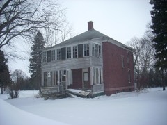 | Pipestone Indian School Superintendent's House | building | 1993 | 93000232 |
 | Pipestone Public Library | building | 1980 | 80002122 |
 | Pipestone Water Tower | structure | 1980 | 80002123 |
| John M. Poorbaugh Block | building | 2023 | 100008546 | |
 | John Rowe House | building | 1980 | 80002118 |
 | Split Rock Bridge | structure | 1989 | 89001823 |
| Stordahl Building | building | 1980 | 80002120 |
Every wildfire the federal occurrence database records inside this county: 2 of them, burning about 47 acres. None started naturally and none was recorded as arson. Each settlement page carries the fires within five miles of it.
| Reported cause | Fires |
|---|---|
| Missing data/not specified/undetermined | 1 |
| Smoking | 1 |
The five largest, by the area the report gives. None of them was recorded as arson.
| Date | Cause | Size | Reported by | Name on the report |
|---|---|---|---|---|
| 28 November 2017 | Smoking | 40 acres | Pipestone National Monument | PIPESTONE LH40 |
| 14 April 2009 | Missing data/not specified/undetermined | 7.0 acres | Minnesota Department of Natural Resources | not named |
Every settlement page carries the fires within five miles of it - see the settlement index below.
The NOAA Storm Events Database holds 334 reports for this county, causing no deaths, no injuries and about $9,936,500 in recorded property damage. Each settlement page carries the reports that name it.
| Kind of event | Reports |
|---|---|
| Hail | 136 |
| Thunderstorm Wind | 89 |
| Flood | 77 |
| Tornado | 15 |
| Flash Flood | 10 |
| Heavy Rain | 4 |
| Lightning | 3 |
The most serious of them, by death, then injury, then recorded damage. The accounts are quoted exactly as the forecast office filed them.
| When | Event | Place named | Harm | What the report says |
|---|---|---|---|---|
| May 1993 | Tornado (F2) | not stated | $5,000,000 | A tornado traveled along an intermittent path east of the towns of Jasper and Pipestone damaging several farmsteads and causing $2.4 million dollars damage. |
| April 1985 | Tornado (F3) | not stated | $2,500,000 | no account filed |
| March 2019 | Flood | Ihlen | $769,000 | Flooding resulted in damage to public infrastructure including county and township roads and culverts. State Highway 30 flooded between 110th and 100th Avenue. The property damage costs include estimates for public property losses. |
| June 2024 | Flood | Ihlen | $250,000 | Rainfall amounts across Pipestone County from June 20-22 ranged from 3 to 6 inches. Some overland flooding ensued with additional minor flooding along Pipestone Creek and North Branch Pipestone Creek. ||Some damages were reported to county and township roads and culverts. Preliminary damage assessments estimate loss to public infrastructure to be 250 thousand dollars. ||For additional information on river flooding, please see other flood entries for Pipestone County. |
| June 1979 | Tornado (F1) | not stated | $250,000 | no account filed |
| June 1969 | Tornado (F2) | not stated | $250,000 | no account filed |
| April 2019 | Flood | Airlie | $100,000 | Runoff from occasional precipitation in late March and early April produced considerable flooding of agricultural land. Pipestone Creek at Pipestone (gage site PIPM5) crested at 3.73 feet above flood stage on April 6, the fifth highest crest on record. |
| June 2014 | Flash Flood | Ihlen | $100,000 | Heavy rain caused flash flooding of numerous roads, including U.S. Highway 75. Many secondary roads were reported to be under water, and major roads suffered damage. |
| April 2011 | Flood | Cazenovia | $100,000 | Flooding of lakes and lowlands, including some farmland, continued in the county through April. While flooding of small streams abated, lake and lowland flooding continued with very slow improvement. Several roads remained flooded. High water and groundwater levels resulting from record precipitation in the previous year was the main reason that the flooding either grew worse or improved so slowly. |
| June 1997 | Hail | Pipestone | $100,000 | no account filed |
| September 2019 | Flash Flood | Pipestone | $75,000 | Within three hours of the start of heavy rainfall, the river gage on Pipestone Creek at Pipestone rose quickly over flood stage. Several homes on the northeast side of Pipestone were inundated with flood water. |
| September 2019 | Flood | Airlie | $50,000 | After excessive two-day rainfall during September 10-12 (record 2-day rainfall of 6.75 inches at Pipestone), Pipestone Creek at Pipestone (gage site PIPM5) reached the highest stage on record of 5.51 feet above flood stage on September 12. Flood waters inundated and damaged all rooms of a motel, and encroached on a neighboring restaurant. Several homes had varying degrees of water damage on the northeast side of Pipestone. Numerous county roads were inundated by water, with extensive amounts of agricultural land flooded. |
| June 2014 | Flood | Cazenovia | $50,000 | Persistent moderate to heavy rain caused flooding of fields and other lowlands, including several roads, homes, and businesses. This flooding lasted for two days, and was aggravated locally by additional storms during that time. Some roads were damaged or washed out. |
| July 2011 | Tornado (EF1) | Ruthton | $50,000 | A tornado destroyed a shelter belt, damaged a Morton building, and damaged several garages, one of which was moved off its foundation. The tornado also caused widespread tree damage, including several trees snapped off at the base. |
| July 2011 | Thunderstorm Wind | Ruthton | $50,000 | Non tornadic thunderstorm winds blew down trees, power poles, and power lines, destroyed a highway shop, and blew the roof off a pallet business. |
| May 2012 | Flood | Pipestone | $30,000 | Heavy rain caused brief but record flooding of Pipestone Creek. Fields, parkland, and roads were flooded, including the Pipestone County fairgrounds. One street in the city of Pipestone caved in. The creek crested at 5.71 feet above flood stage on May 6th. |
| June 2011 | Lightning | Pipestone | $25,000 | Lightning struck an apartment building, starting a fire in the attic which heavily damaged an upstairs apartment. Another upstairs apartment suffered water damage, while two basement apartments were undamaged. Six residents home in the apartments at the time of the lightning strike escaped uninjured. |
| September 2010 | Flash Flood | Trosky | $25,000 | Heavy rain caused flash flooding of numerous roads in much of central and southern Pipestone County, including Minnesota Highway 30 at several locations. The town of Edgerton was temporarily isolated by the flooding. Several motorists were stranded, and some water rescues were needed. there was widespread flooding of fields, parks and other lowlands, as well as basement flooding. |
| June 1979 | Tornado (F0) | not stated | $25,000 | no account filed |
| July 1999 | Thunderstorm Wind | Woodstock | $20,000 | no account filed |
| September 2019 | Flood | Cazenovia | $15,000 | After excessive two-day rainfall during September 10-12 (8.93 inches at Flandreau and 8.64 inches near Pipestone), Flandreau Creek near Flandreau (gage site FCRS2) reached the highest stage on record of 5.46 feet above flood stage on September 12. Numerous township and county roads were inundated by water, as well as significant amounts of agricultural land. |
| August 2010 | Thunderstorm Wind | Edgerton | $15,000 | Thunderstorm winds blew the roof off a bowling alley, and caused tree damage. |
| September 2019 | Flood | Trosky | $10,000 | After excessive two-day rainfall during September 10-12 (9.08 inches near Edgerton), the Rock River near Hardwick (gage site HRDM5) reached the second highest stage on record of 6.14 feet above flood stage on September 12. Numerous county roads were under water near Edgerton, with significant flooding of agricultural land. The city park was under several feet of water. |
| September 2019 | Flood | Ihlen | $10,000 | After excessive two-day rainfall during September 10-12 (record 2-day rainfall of 6.75 inches at Pipestone), Split Rock Creek below Jasper (gage site JSPM5) reached the highest stage on record of 9.39 feet above flood stage on September 12. Numerous county roads were under water near Sherman, including 250th Street. Significant amounts of agricultural land were flooded. |
| September 2019 | Flood | Cazenovia | $10,000 | After excessive two-day rainfall during September 10-12 (record 2-day rainfall of 6.75 inches at Pipestone), the North Branch of Pipestone Creek near Pipestone (gage site PSNM5) reached the highest stage on record of 1.66 feet above flood stage on September 12. Several county roads were inundated by water, with extensive amounts of agricultural land flooded. |
| September 2019 | Flood | Airlie | $10,000 | After excessive two-day rainfall during September 10-12 (record 2-day rainfall of 6.75 inches at Pipestone), Pipestone Creek below Pipestone (gage site PSTM5) reached the highest stage on record of 1.74 feet above flood stage on September 12. A water rescue was necessary when a motorist drove into rapidly flowing waters on State Highway 30 around 315 am on September 12. In total, 13.5 miles of county maintained roads were under water at one point. Significant flooding of agricultural land occurred. |
| June 1997 | Heavy Rain | Edgerton | $10,000 | no account filed |
| June 1996 | Hail | Pipestone | $10,000 | no account filed |
| August 2010 | Thunderstorm Wind | Ihlen | $5,000 | Thunderstorm winds blew down power lines. |
| May 2004 | Thunderstorm Wind | Pipestone | $5,000 | Thunderstorm winds blew down power lines near state highway 30 just east of the South Dakota state line. |
| September 1999 | Thunderstorm Wind | Ruthton | $5,000 | Thunderstorm winds caused tree damage, including large branches blown down. |
| July 1999 | Thunderstorm Wind | Ruthton | $5,000 | no account filed |
| May 1971 | Tornado (F0) | not stated | $2,500 | no account filed |
| June 1966 | Tornado (F0) | not stated | $2,500 | no account filed |
| May 2014 | Thunderstorm Wind | Hatfield | $1,000 | Thunderstorm winds blew the roof off a machine shed. |
| May 2012 | Thunderstorm Wind | Airlie | $1,000 | Thunderstorm winds caused tree damage, including several trees blown down. The winds also blew a canopy off a trailer. |
| May 1996 | Lightning | Edgerton | $500 | no account filed |
| May 2025 | Thunderstorm Wind | Ihlen | - | Significant tree damage and large limbs downed from thunderstorm wind gusts. |
| May 2025 | Thunderstorm Wind | Holland | - | Thunderstorm wind gusts measured by a personal weather station. |
| August 2025 | Thunderstorm Wind | Edgerton | - | Three inch diameter branches were downed by thunderstorm wind gusts. |
| August 2025 | Hail | Cazenovia | - | Hail caused some minor crop damage. Thunderstorm winds also stripped a few 3 to 4 inch diameter tree branches down. |
| September 2025 | Thunderstorm Wind | Pipestone | - | Thunderstorm wind gusts blew down a large tree and knocked out power across much of Pipestone. There was not much rain, but a couple minutes of very strong wind. |
| July 2024 | Thunderstorm Wind | Edgerton | - | Numerous 2 to 3 inch branches were downed by thunderstorm winds near downtown Edgerton. |
| June 2024 | Flood | Airlie | - | Pipestone Creek below Pipestone rose above flood stage the morning of June 21st, cresting around 0.92 feet above flood stage (1595.92 feet) on June 22nd. The creek then fell below flood stage on the morning of June 24th. For a more comprehensive description of flood damage, please see other entries for Pipestone County. |
| June 2024 | Flood | Ihlen | - | Split Rock Creek below Jasper rose above flood stage the morning of June 21st, cresting around 9.10 feet above flood stage (100.10 feet) on June 22nd. This crest is in the Major Stage. The creek then fell below flood stage on the morning of June 27th. For a more comprehensive description of flood damage, please see other entries for Pipestone County. |
| June 2024 | Flood | Cazenovia | - | The North Branch of Pipestone Creek near Pipestone rose above flood stage the morning of June 21st, cresting around 0.88 feet above flood stage (44.88 feet) on June 22nd. The creek then fell below flood stage on the morning of June 24th. For a more comprehensive description of flood damage, please see other entries for Pipestone County. |
| June 2024 | Flood | Cazenovia | - | Flandreau Creek near Flandreau rose above flood stage the morning of June 22nd, cresting around 2.46 feet above flood stage (11.46 feet) on June 22nd. This crest is in the Moderate Stage. The creek then fell below flood stage on the afternoon of June 24th. For a more comprehensive description of flood damage, please see other entries for Pipestone County. |
| April 2023 | Flood | Cazenovia | - | Flandreau Creek near Flandeau, SD rose above flood stage on the early morning of April 9th before cresting around 0.28 feet above flood stage (9.28 feet) on April 9th. The creek then quickly fell below flood stage midday on April 9th. |
| April 2023 | Flood | Trosky | - | The Rock River near Hardwick, MN rose above flood stage on the evening of April 9th before cresting around 1.36 feet above flood stage (15.36 feet) on April 12th. The river then fell below flood stage on the morning of April 13th. |
| July 2023 | Hail | Ruthton | - | Winds accompanying the hail were from 45 to 50 mph. Crop damage is an estimate from insured losses. Information provided by the United States Department of Agriculture. |
| June 2022 | Thunderstorm Wind | Ihlen | - | Wind gusts of at least 70 mph caused damage to tree limbs. |
| June 2022 | Thunderstorm Wind | Airlie | - | Multiple two-inch tree branches were downed by thunderstorm winds. |
| June 2022 | Thunderstorm Wind | Trosky | - | Several branches were downed by thunderstorm wind gusts. |
| May 2022 | Thunderstorm Wind | Trosky | - | A thunderstorm wind gust of 80 mph was measured by the Minnesota Road Weather Information System site near Trosky. Crop damage is an estimate from insured losses. Information provided by the United States Department of Agriculture. |
| May 2022 | Hail | Ihlen | - | Crop damage is an estimate from insured losses. Information provided by the United States Department of Agriculture. |
| May 2022 | Flood | Airlie | - | An average of 1 to 2 inches of rainfall occurred in the basin north of Pipestone on May 11, and resultant runoff produced a quick rise into minor flood stage. Pipestone Creek at Pipestone (gage site PIPM5) crested 0.76 feet above flood stage early on May 12. Small tracts of agricultural land succumbed to minor flooding. |
| May 2022 | Flood | Airlie | - | An average of 1 to 2 inches of rainfall occurred in the basin north of Pipestone on May 11, and resultant runoff produced a quick rise into minor flood stage. Pipestone Creek below Pipestone (gage site PSTM5) crested briefly 0.09 feet above flood stage early on May 12. Small tracts of agricultural land succumbed to minor flooding. |
| May 2022 | Thunderstorm Wind | Trosky | - | A thunderstorm wind gust of 63 mph was measured by the Minnesota Road Weather Information System site at Trosky. |
| May 2022 | Flood | Cazenovia | - | An average of 1 to 2 inches of rainfall occurred in the basin north of Pipestone on May 11, and resultant runoff produced a quick rise into minor flood stage. The North Branch of Pipestone Creek near Pipestone (gage site PSNM5) crested 0.49 feet above flood stage early on May 12. Small tracts of agricultural land succumbed to minor flooding. |
| May 2022 | Tornado (EFU) | Ihlen | - | A video showed a brief tornado spinning up in open farmland. The tornado caused no damage from which the NWS could assign an EF-scale rating. The average path width was estimated at 20 yards. |
The Survey's mineral resources record lists 2 workings inside this county. All of them still produce. Each settlement page carries the workings within five miles of it.
| Commodity | Workings |
|---|---|
| Sand and Gravel, Construction | 1 |
| Clay | 1 |
The least common of them first, because a county's hundredth gravel pit says nothing its first ten did not.
| Where | Site | Commodity | Status | Recorded |
|---|---|---|---|---|
| Pipestone Quarry | Clay | Producer | ||
| Rock Rv Wash Plant | Sand and Gravel, Construction | Producer |
An Illustrated History of the Counties of Rock and Pipestone, Minnesota devotes a chapter to each township: its boundaries and streams, who settled it and when, the mills, the schools and the churches. All 9 are reproduced here in full. Each row shows the township's own shape and where it lies in the county, drawn from the Census Bureau's boundary. Which settlements belong to which township is computed from that same boundary, not taken from the book.
| Shape and position in the county | Township | Settlements in it | Length | Sections |
|---|---|---|---|---|
| Aetna Township | Ruthton | 198 words | 0 | |
| Burke Township | Diamond Corner, Woodstock | 683 words | 3 | |
| Eden Township | Ihlen | 93 words | 0 | |
| Edgerton City | Edgerton | 3,855 words | 5 | |
| Hatfield City | Hatfield | 3,663 words | 2 | |
| Pipestone City | Pipestone | 7,107 words | 11 | |
| Sweet Township | Airlie | 558 words | 0 | |
| Trosky City | Trosky | 2,436 words | 6 | |
| Troy Township | Cazenovia, Cresson | 202 words | 0 |
One book written about this county, cut here where the book itself is cut, at its printed chapters: 13 chapters in all. Every chapter is public domain, machine-read from the scan and reproduced complete. A chapter already given under one of the county's towns is not repeated in this list.
| Chapter | Length |
|---|---|
| Chapter with an unread heading (no. 1 of those read) | 1,516 words |
| Chapter 17: In the Reign of Gitche Iianitou | 5,611 words |
| Chapter 18 | 6,474 words |
| Chapter 19 | 6,127 words |
| Chapter 21: The Railway Age - 1879-1884 | 6,613 words |
| Chapter 22: Current Events - 1885-1911 | 6,128 words |
| Chapter 23: Political - 1874-1911 | 4,157 words |
| Chapter 25: Pipestone's Institutions | 7,538 words |
| Chapter 27: Holland and Ruthton | 5,011 words |
| Chapter 30: Descriptive | 5,143 words |
| Chapter 31 | 3,767 words |
| Chapter 32: Reservation Squatters | 4,781 words |
| Chapter 34: Pipestone County Biographical | 101,390 words in 7 parts |
Named settlements recorded in the Geographic Names Information System, each with the topographic sheets covering it. Villages, hamlets and abandoned places alike. Each is shown with the nearest named watercourse or landform and the survey quadrangle it falls on.
Edgerton city · 56128 · On Chanarambie Creek · Edgerton South quadrangle
7 sheets, 1955 to 1985