 Block
From the record
14 National Register listings published here.
Sources: the National Register database, National Park Service
37 topographic sheets cover 20 settlements here, and 14 properties are on the National Register of Historic Places.
14 National Register listings published here.
Sources: the National Register database, National Park Service
Every property in this county listed on the National Register of Historic Places, with the year it was listed and the federal nomination document.
| Photograph | Property | Type | Listed | Reference |
|---|---|---|---|---|
 | Bank of Long Prairie | building | 1985 | 85001994 |
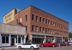 | Batcher Opera House Block | building | 2004 | 04000837 |
 | Bridge No. L7075 | structure | 2016 | 16000158 |
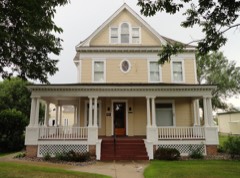 | Dr. George R. Christie House | building | 2006 | 06001184 |
 | Church of St. Joseph-Catholic | building | 1985 | 85001996 |
| Eagle Bend High School | building | 2024 | 100010559 | |
 | Germania Hall | building | 1995 | 95001377 |
 | Grey Eagle Village Hall | building | 1985 | 85001992 |
 | Hewitt Public School | building | 2006 | 06001181 |
 | Hotel Reichert | building | 1985 | 85001995 |
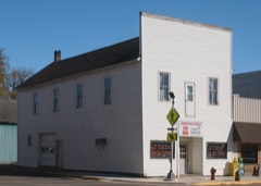 | Kahlert Mercantile Store | building | 1985 | 85001997 |
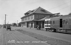 | Northern Pacific Railway Depot and Freighthouse | building | 2008 | 85003613 |
 | Saint Cloud and Red River Valley Stage Road-Kandota Section | structure | 1991 | 91001061 |
 | Todd County Courthouse, Sheriff's House and Jail | building | 1985 | 85001986 |
Every wildfire the federal occurrence database records inside this county: 487 of them, burning about 8,271 acres. 6 started naturally and 99 were recorded as arson. Each settlement page carries the fires within five miles of it.
| Reported cause | Fires |
|---|---|
| Debris and open burning | 233 |
| Arson/incendiarism | 99 |
| Missing data/not specified/undetermined | 58 |
| Equipment and vehicle use | 56 |
| Railroad operations and maintenance | 13 |
| Recreation and ceremony | 11 |
| Smoking | 9 |
| Natural | 6 |
| Misuse of fire by a minor | 1 |
| Power generation/transmission/distribution | 1 |
The five largest, by the area the report gives. Two of them were set deliberately.
| Date | Cause | Size | Reported by | Name on the report |
|---|---|---|---|---|
| 11 April 2015 | Equipment and vehicle use | 1,725 acres | Minnesota Department of Natural Resources | not named |
| 18 March 2000 | Arson/incendiarism | 440 acres | Minnesota Department of Natural Resources | BEAUTY LAKE |
| 24 March 2003 | Debris and open burning | 332 acres | Minnesota Department of Natural Resources | not named |
| 27 March 2007 | Debris and open burning | 304 acres | Minnesota Department of Natural Resources | NORRIS ROAD FIRE |
| 5 April 1992 | Debris and open burning | 287 acres | Minnesota Department of Natural Resources | not named |
| 13 April 2004 | Debris and open burning | 200 acres | Minnesota Department of Natural Resources | not named |
| 28 February 2000 | Arson/incendiarism | 200 acres | Minnesota Department of Natural Resources | not named |
| 11 April 2012 | Equipment and vehicle use | 175 acres | Minnesota Department of Natural Resources | not named |
Every settlement page carries the fires within five miles of it - see the settlement index below.
The NOAA Storm Events Database holds 286 reports for this county, causing no deaths, 1 injury and about $2,109,700 in recorded property damage. Each settlement page carries the reports that name it.
| Kind of event | Reports |
|---|---|
| Hail | 142 |
| Thunderstorm Wind | 98 |
| Tornado | 25 |
| Funnel Cloud | 9 |
| Flash Flood | 9 |
| Heavy Rain | 2 |
| Flood | 1 |
The most serious of them, by death, then injury, then recorded damage. The accounts are quoted exactly as the forecast office filed them.
| When | Event | Place named | Harm | What the report says |
|---|---|---|---|---|
| July 2000 | Tornado (F2) | Staples | 1 hurt | Roofs blown off homes and one business. At least one dozen homes damaged. Numerous large trees down. One minor injury in Staples due to flying glass. Tornado crossed over from Wadena county. |
| July 2015 | Tornado (EF1) | Hewitt | $500,000 | A tornado moved out of Wadena County (where it was rated EF2) and into Todd County. A barn was collapsed just south of Aldrich, with roofing material blown 1/2 mile downwind. Dozens of trees were broken or uprooted in this area. Several wooden power poles were snapped. An outbuilding was also destroyed. Farther east, an outbuilding was destroyed along with a roof partially blown off near the intersection of 500th street and 223rd Avenue, just northwest of Dower Lake. Significant tree damage was noted on the northeast side of Dower Lake, and concentrated damage continued in a path to about two miles west of Staples. Separate entries have also been made for numerous trees blown down due to the rear flank downdraft and downbursts north of the tornado track. |
| June 2024 | Flash Flood | Browerville | $400,000 | Todd County had numerous culverts washed out. The heaviest rain fell north of Clarissa. Measured 5.62 in Clarissa, 6 to 8 public reports elsewhere. There was also damage to a few structures from the flood waters, with an estimated $400,000 in total damages. |
| April 2001 | Flash Flood | Countywide | $200,000 | no account filed |
| June 2018 | Thunderstorm Wind | Pillsbury | $150,000 | A farm was severely damaged as a concentrated area of wind damage occurred northeast of Long Prairie. The farm was located on Indigo Drive where the owner reported hundreds of trees blown down on his farm. The barn was completely destroyed with damage to a fence and home. |
| May 2022 | Thunderstorm Wind | Clotho | $100,000 | A shed and old barn collapsed. Several dozen trees were also broken. Damage was most likely due to a downburst per the NWS survey. Time was estimated based on radar. |
| August 2016 | Thunderstorm Wind | Long Prairie | $100,000 | Numerous trees were blown down in Long Prairie. The most concentrated area of damage occurred on the south and northeast part of town. One tree landed on a home and damaged it. Building material from roofs was also blown off in the downtown area. The material that blew off also damaged adjacent buildings. |
| July 2015 | Thunderstorm Wind | Hewitt | $100,000 | A damage survey revealed that a rear flank downdraft (RFD) accompanied a tornado, and produced tree damage to the south of the tornado track. Numerous trees were tipped over and large branches were broken. Once the tornado dissipated about two miles west of Staples, the RFD broadened out and swept across the south side of Staples, where it continued to topple dozens of trees. The last damage noted from the RFD was southeast of Staples. Several outbuildings were damaged, and trees fell across many vehicles. |
| July 2010 | Thunderstorm Wind | Staples Muni | $100,000 | Dozens of trees were toppled in and around Staples, with some trees landing on vehicles, sheds and houses. The roof of a hardware store was partially removed. |
| June 2001 | Flash Flood | Long Prairie | $100,000 | Highway 27 flooded in Long Prairie. Road washed out 5 E Long Prairie. |
| July 2020 | Thunderstorm Wind | Browerville | $50,000 | The local emergency manager, and pictures and drone video of damage, indicated that downburst winds caused damage to a few outbuildings and sheds northeast of Browerville, and a swath of large trees was blown down approximately 8 miles east of Browerville. |
| September 2014 | Thunderstorm Wind | Staples | $50,000 | Several trees and power lines were blown down in the City of Staples. In addition, the Staples airport, approximately 1 mile north of downtown Staples, in Wadena County, had a measured wind gust of 79 mph at 531 CST. |
| July 2003 | Thunderstorm Wind | Staples | $50,000 | Numerous trees were snapped or uprooted. Some trees came down on homes and sheds. The roofs of two garages were blown off, and a camper was rolled about 40 feet. Most damage was in the south side of town. |
| June 2001 | Thunderstorm Wind | Long Prairie | $50,000 | Semi trailer flipped over. Sheds, silos, and numerous trees down. Damage caused by rear flank downdraft that accompanies tornado. As determined by NWS damage survey. |
| August 2020 | Tornado (EF1) | Philbrook | $25,000 | An NWS survey found damage consistent with an EF-1 tornado in northeastern Todd County about 6 miles west of Cushing. The tornado touched down 0.2 miles northwest of Big Lake and traveled north-northeast for nearly 5.2 miles as it moved into Morrison County, near Lincoln. The most significant damage in Todd County was along Star Lake, where several hundred trees were broken and uprooted. |
| September 2014 | Thunderstorm Wind | Hewitt | $25,000 | Several trees were blown down in Hewitt, along Highway 210, plus a roof was blown off a building. |
| July 2009 | Flash Flood | Staples | $25,000 | Several thunderstorm complexes moved through northern Todd and northwestern Morrison Counties where locally four to six inches of rain fell in less than two hours. Due to poor drainage and the excessive rainfall, flash flooding developed in the town of Staples where evacuation occurred in homes on 5th street, and power was shut off to Staples High Rise Apartments on 4th street due to the high water. |
| May 1957 | Tornado (F1) | not stated | $25,000 | no account filed |
| July 2014 | Thunderstorm Wind | Staples | $15,000 | Roof damage occurred in the town of Staples along with power outages. |
| August 2020 | Tornado (EF0) | West Union | $10,000 | A tornado damaged a garage that was rotated slightly, and its door was bowed out, and a few shingles were damaged. Other damage was associated with large tree limbs blown down along the tornado's path. |
| June 2001 | Tornado (F3) | Bertha | $10,000 | NWS Grand Forks damage survey revealed an F3 tornado touch down in Otter Tail County, one mile NW of Parkers Prairie at 1753 CST. It tracked to just southeast of Wrightstown, for an 11 mile path in Otter Tail County. It then continued on for one mile in Todd County where it dissipated 3 WNW of Bertha. Total path length 12 miles. |
| August 2001 | Thunderstorm Wind | Eagle Bend | $10,000 | Large tree toppled, crashed through residential roof. |
| July 2010 | Thunderstorm Wind | Long Prairie | $5,000 | Several trees were blown down west of Long Prairie, Minnesota. In addition, there were reports of ponding of water on city streets, and standing water in some farm fields. |
| August 1990 | Tornado (F0) | not stated | $2,500 | no account filed |
| July 1971 | Tornado (F0) | not stated | $2,500 | no account filed |
| July 1966 | Tornado (F0) | not stated | $2,500 | no account filed |
| March 2012 | Thunderstorm Wind | Eagle Bend | $2,000 | Severe thunderstorm winds caused damage to a barn, and a few trees to snap off near Eagle Bend, Minnesota. |
| May 2013 | Hail | West Union | $200 | Ping Pong ball size hail broke the windshield of a truck. |
| June 2025 | Thunderstorm Wind | Bertha | - | Law enforcement dispatch reported roof blown off of barn near Bertha. |
| July 2025 | Thunderstorm Wind | Philbrook | - | Multiple trees were downed near US10 south of Motley and just west of the Morrison/Todd County line. Relayed via county dispatch. |
| July 2025 | Thunderstorm Wind | Browerville | - | Portion of a shed's roof blown off and Fish house blown around along CR 29 north of Mill Lake or six miles east-southeast of Bowerville. The AWOS station approximately seven miles SW of this location recorded a 45-mph wind gust. |
| August 2024 | Hail | Browerville | - | Photo measurement provided via social media. |
| August 2024 | Thunderstorm Wind | Grey Eagle | - | Video on social media showing full size pine trees snapped in half. |
| August 2024 | Hail | Grey Eagle | - | Photo measurement provided via social media. |
| August 2024 | Thunderstorm Wind | Grey Eagle | - | Photos shared via social media of large tree uprooted. |
| August 2024 | Hail | Long Prairie | - | Photo submitted via social media of golf ball size hail. |
| July 2024 | Thunderstorm Wind | Long Prairie Muni Ar | - | Trees down on 243rd Ave near Long Prairie. |
| July 2024 | Thunderstorm Wind | Grey Eagle | - | Trees down near Buckhead Lake. |
| June 2024 | Thunderstorm Wind | Burtrum | - | Multiple trees were down within town. |
| June 2023 | Thunderstorm Wind | West Union | - | A trained spotter reported a 20 inch diameter pine tree snapped, with a photo relayed via social media. |
| June 2023 | Hail | West Union | - | A trained spotter reported that the hail had shredded some corn as seen in a photo that the spotter provided to NWS Twin Cities. |
| May 2022 | Tornado (EF1) | Staples | - | A tornado developed in far northern Todd County and hit two farmsteads before exiting into Wadena County (see corresponding entry from NWS Grand Forks). At the first farmstead, a garage door was blown in and part of the garage roof came off. Maximum winds for the Todd County portion were estimated to be 90 mph. |
| May 2022 | Tornado (EF1) | Hewitt | - | A tornado developed in far northwest Todd County and moved into Wadena County (see separate entry from NWS Grand Forks). On the Todd County side of the county line, the tornado hit a farmstead and destroyed two tin sheds, leading to estimated maximum winds in Todd County of 90 mph. The debris was strewn in a narrow path. The tornado also broke or uprooted a number of trees. Damage assessment was aided by photographs (not included here) provided by the Todd County Sheriff's Office. |
| May 2022 | Tornado (EF1) | Clarissa | - | Hundreds of trees were uprooted or broken. Several outbuildings lost roofs. The damage pattern in this part of Todd County was very complicated, but ground and aerial surveys revealed a tornado moved through part of Clarissa. Maximum winds were estimated at 90 mph. |
| May 2022 | Thunderstorm Wind | Clotho | - | A metal roof was blown off a barn, which then collapsed. Siding was ripped off some outbuildings. About one dozen trees were felled. A 2x4 was driven through the fiberglass of a boat and other items were blown around a farm. It was inconclusive whether this was from downburst or a QLCS tornado. Time estimated based on radar and a storm photo from a local resident. |
| May 2022 | Tornado (EF1) | Eagle Bend | - | This tornado tore through the eastern side of Eagle Bend. It knocked down or snapped many trees, partially removed roofs from several houses, peeled tin off the roof of multiple sheds and buildings, and took the top off three massive and filled grain bins in Eagle Bend. Multiple farmsteads were hit, destroying barns, machine sheds, and other outbuildings. It ended about 5 miles west-southwest of Staples where the scattered tree damage pattern could no longer be determined to be of tornadic origin. Determination of the specific path was assisted by Todd County Emergency Management, which provided drone imagery to the NWS. Maximum winds were estimated to be 100 mph. |
| August 2020 | Thunderstorm Wind | Browerville | - | Several trees were blown down east of Browerville, along Highway 16. |
| July 2020 | Thunderstorm Wind | Staples | - | Several trees were blown down along with power lines. |
| July 2020 | Hail | Bertha | - | No major damage around Hewitt or Bertha but a few hail stones of 3/4 of an inch fell in the area, and some small tree limbs blown down between Hewitt and Bertha. |
| July 2020 | Thunderstorm Wind | Bertha | - | A large 10 inch diameter tree was blown down at County Road 24, and 157th Avenue. |
| July 2020 | Hail | Philbrook | - | There were several reports of quarter size hail just north of the Todd/Cass County border, and also southeast into northeast Todd County. |
| July 2020 | Funnel Cloud | Hewitt | - | A storm chaser reported a funnel cloud and provided video. The funnel cloud may have made ground contact, but it was not possible to determine that from the video or in discussions with the chaser. Nor was there any damage reported, so this was documented as a funnel cloud. |
| July 2019 | Hail | West Union | - | This is the continuation of a swath of large hail that developed across Stevens County, and moved northeast across northwest Pope, southeast Douglas, and over the southern part of Todd County. There was a measured report of golf ball size hail north of West Union. This swath of large hail continued to north of Swanville. |
| June 2018 | Thunderstorm Wind | West Union | - | A large tree was blown down north of West Union. |
| June 2018 | Thunderstorm Wind | Pillsbury | - | A large tree was blown down southwest of Pillsbury. |
| May 2017 | Thunderstorm Wind | Long Prairie | - | A four inch diameter tree was blown down near Long Prairie. |
| September 2017 | Tornado (EF1) | Burtrum | - | A tornado touched down on the east side of Big Swan Lake, where a few trees were downed. As the tornado moved northeast, it hit a number of lake homes and cabins, causing roof damage to several. As the tornado reached the community of Pillsbury on the northeast side of Long Lake, a boat and attached dock were blown westward into the lake. Dozens of trees, including some two feet in diameter, were blown down or snapped. A home was shifted off its foundation by several inches. Another home sustained minor damage to the roof and had some windows blown in. The tornado continued beyond Pillsbury, moving across open fields and woods, and dissipated just as it reached the Todd/Morrison County line. |
| July 2017 | Tornado (EF0) | Clarissa | - | Several hundred trees were toppled or broken. A few trees landed on power lines. One old barn collapsed, but no other structural damage was noted or reported. |
| June 2016 | Hail | Clotho | - | Most of the hail was less than 3/4 of an inch. |
| August 2016 | Heavy Rain | Pillsbury | - | A trained spotter measured 5.32 inches of rain near Pillsbury. |
The Survey's mineral resources record lists 11 workings inside this county. 10 still produce and 1 is closed or unrecorded. Each settlement page carries the workings within five miles of it.
| Commodity | Workings |
|---|---|
| Sand and Gravel, Construction | 11 |
The least common of them first, because a county's hundredth gravel pit says nothing its first ten did not.
| Where | Site | Commodity | Status | Recorded |
|---|---|---|---|---|
| Browerville Pit | Sand and Gravel, Construction | Producer | ||
| Cary Pit | Sand and Gravel, Construction | Producer | ||
| Haskamp Pit | Sand and Gravel, Construction | Producer | ||
| Lambrecht Pit | Sand and Gravel, Construction | Producer | ||
| Peterson Pit | Sand and Gravel, Construction | Producer | ||
| Sanders Pit | Sand and Gravel, Construction | Past Producer | ||
| Smith Pit | Sand and Gravel, Construction | Producer | ||
| Stueve Pit | Sand and Gravel, Construction | Producer | ||
| Todd County Pit No 21 | Sand and Gravel, Construction | Producer | ||
| Winters Pit | Sand and Gravel, Construction | Producer | ||
| Zetah Pit | Sand and Gravel, Construction | Producer |
Named settlements recorded in the Geographic Names Information System, each with the topographic sheets covering it. Villages, hamlets and abandoned places alike. Each is shown with the nearest named watercourse or landform and the survey quadrangle it falls on.
Browerville city · 56438 · On Harris Creek · Browerville quadrangle
9 sheets, 1953 to 1986
Long Prairie city · 56347 · On Venewitz Creek · Long Prairie quadrangle
9 sheets, 1953 to 1986
Grey Eagle township · 56336 · On Fish Creek · Burtrum quadrangle
10 sheets, 1950 to 1986
Bruce township · 56382 · On Moose Lake Creek · Swanville quadrangle
10 sheets, 1950 to 1986
Grey Eagle township · 56336 · On Fish Creek · Burtrum quadrangle
10 sheets, 1950 to 1986
Birchdale township · 56336 · On Prairie Creek · Ward Springs quadrangle
8 sheets, 1953 to 1986