BlockBefore
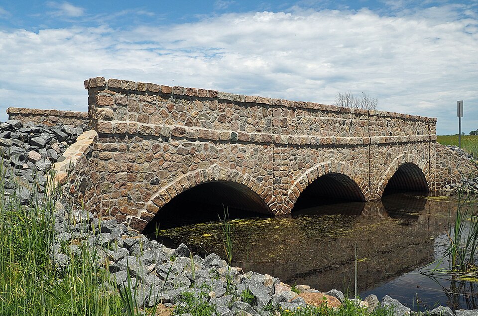
Photograph of Bridge L7075
Photograph by McGhiever, CC BY-SA 4.0. Via Wikimedia Commons.

Bridge No. L7075

Listed on the National Register of Historic Places in 2016.

From the record

“Bridge L7075 is a historic arch bridge in Hartford Township, Minnesota, United States. It was initially built around 1940 by the Works Progress Administration with a modular corrugated iron product called Multi Plate for the arches and a masonry façade.”

Wikipedia article Bridge L7075, CC BY-SA 4.0.

One of 14 National Register listings published here for Todd County · listed in 2016 · category: Structure.

Sources: the Wikipedia article · the National Register database, National Park Service
The listing

Fires near this property

47 since 1992

Regional context, not property-specific evidence. The federal wildfire occurrence database lists 47 fires within 5 miles of Bridge No. L7075 between 1992 and 2019, burning about 372 acres in total. 2 started naturally. 11 were recorded as arson. Distance is straight-line from the map coordinates, so a fire counted here may appear on a neighbouring settlement's page as well.

Reported cause Fires
Debris and open burning21
Arson/incendiarism11
Equipment and vehicle use6
Missing data/not specified/undetermined5
Natural2
Smoking1
Recreation and ceremony1

The most recent of them, most recent first, with the day each was reported and the service that recorded it.

DateCause SizeReported by Name on the report
11 August 2002Smokingunder an acreMinnesota Department of Natural Resourcesnot named
5 July 1996Arson/incendiarismunder an acreMinnesota Department of Natural Resourcesnot named
12 June 1997Debris and open burning1.0 acresMinnesota Department of Natural Resourcesnot named
7 May 1996Recreation and ceremony3.0 acresMinnesota Department of Natural Resourcesnot named
7 May 1992Debris and open burning6.0 acresMinnesota Department of Natural Resourcesnot named
6 May 2018Equipment and vehicle use76 acresMinnesota Department of Natural Resourcesnot named
5 May 2006Debris and open burning2.0 acresMinnesota Department of Natural Resourcesnot named
4 May 1996Debris and open burningunder an acreMinnesota Department of Natural Resourcesnot named

Every fire recorded in Todd County

Mines and quarries near this property

1 within 5 miles

Regional context, not property-specific evidence. The federal mineral resources record lists 1 working within 5 miles of Bridge No. L7075: 1 producer. All of them still produce. What was taken out: Sand and Gravel, Construction. Distance is straight-line from the map coordinates, so a quarry counted here may appear on a neighbouring settlement's page as well.

Where SiteCommodity StatusRecorded
Browerville PitSand and Gravel, ConstructionProducer

Every working recorded in Todd County

Storms near this property

19 since 1996

Regional context, not property-specific evidence. The National Weather Service names Browerville, the town this property stands in, in 19 storm reports between 1996 and 2025: 9 hail, 8 thunderstorm wind, 1 tornado, 1 flash flood. No death or injury is recorded in these reports. Each account below is quoted exactly as the forecast office filed it, from the NOAA Storm Events Database, and each date opens the federal record of that event.

WhenEvent Place namedHarm What the report says
June 2024Flash FloodBrowerville$400,000Todd County had numerous culverts washed out. The heaviest rain fell north of Clarissa. Measured 5.62 in Clarissa, 6 to 8 public reports elsewhere. There was also damage to a few structures from the flood waters, with an estimated $400,000 in total damages.
July 2020Thunderstorm WindBrowerville$50,000The local emergency manager, and pictures and drone video of damage, indicated that downburst winds caused damage to a few outbuildings and sheds northeast of Browerville, and a swath of large trees was blown down approximately 8 miles east of Browerville.
July 2025Thunderstorm WindBrowerville-Portion of a shed's roof blown off and Fish house blown around along CR 29 north of Mill Lake or six miles east-southeast of Bowerville. The AWOS station approximately seven miles SW of this location recorded a 45-mph wind gust.
August 2024HailBrowerville-Photo measurement provided via social media.
August 2020Thunderstorm WindBrowerville-Several trees were blown down east of Browerville, along Highway 16.
July 2015Thunderstorm WindBrowerville-Several trees and power lines were blown down near Browerville.
August 2015Thunderstorm WindBrowerville-A few trees were uprooted north of Browerville on Highway 71.
August 2004Tornado (F0)Browerville-An off-duty emergency manager witnessed a brief touchdown of a tornado 3 miles south of Browerville, 1/2 mile east of Highway 71. No damage was reported.
August 2004HailBrowerville-The hail swath was one mile wide and went from Browerville eastward into Morrison County.
July 2003Thunderstorm WindBrowerville-Another wide swath of damaging wind moved through Todd County, this time affecting the east central portion. It was associated with a three mile long tornado from 1500 to 1505 that began in Todd County and briefly entered Morrison County. The NWS damage survey determined, however, that the vast majority of the widespread damage was due to the strong downburst. Thousands of trees were felled, including many hundred that snapped. Some trees fell on houses, outbuildings and vehicles. All trees from the downburst were oriented from northeast to southwest.
June 1997Thunderstorm WindBrowerville-Trees down. Estimated windspeed.
August 2024HailBrowerville-no account filed
June 2024HailBrowerville-no account filed
May 2018HailBrowerville-no account filed
September 2005HailBrowerville-no account filed
June 2003HailBrowerville-no account filed
June 2001HailBrowerville-no account filed
August 1996Thunderstorm WindBrowerville-no account filed

Every storm recorded in Todd County

Map coverage status

No historic map-sheet match is published for this property yet. That does not mean no map exists. This record needs a coordinate-quality review before it can be joined to a sheet boundary. Browse the county's mapped places while that work is pending.

Listed places nearby

6 within 8 miles

Other National Register properties close enough to walk or drive between, ordered by distance from this one. Both positions come from the same geocoding pass that matched these properties to their map sheets.

Photograph PropertyDistance Listed
Kahlert Mercantile Store3.6 miles1985
Church of St. Joseph-Catholic3.7 miles1985
Hotel Reichert5.6 miles1985
Bank of Long Prairie5.7 miles1985
Dr. George R. Christie House5.8 miles2006
Todd County Courthouse, Sheriff's House and Jail5.8 miles1985

Sources for this property

National Archives recordThe nomination case file for reference 16000158 in Record Group 79.
Wikipedia articleCommunity-written account of this property, licensed CC BY-SA.
Todd CountyAll 14 listed properties in this county.

Provenance

  • Listing record. National Park Service National Register of Historic Places, listed-properties dataset, current to 2026-05-22.
  • Map join. Address geocoded through the United States Census geocoder, then tested against the published boundary of every sheet in the USGS Historical Topographic Map Collection.
  • How this page is made. Listing fields come from federal records; map-sheet coverage is a labelled coordinate-to-boundary calculation, not a source-field claim.
  • Wildfire. Short, Karen C. 2022. Spatial wildfire occurrence data for the United States, 1992-2020 [FPA_FOD_20221014]. 6th Edition. Fort Collins, CO: Forest Service Research Data Archive. https://doi.org/10.2737/RDS-2013-0009.6 Collected with United States Government funding and usable without additional permissions or fees.
  • Mines and quarries. USGS Mineral Resources Data System (MRDS) https://mrdata.usgs.gov/mrds/ A work of the United States government, no copyright under 17 U.S.C. 105.
  • Storms. NOAA National Centers for Environmental Information, Storm Events Database https://www.ncei.noaa.gov/stormevents/ A work of the United States government, no copyright under 17 U.S.C. 105. Narratives are quoted verbatim from the National Weather Service report and are not edited or summarised.