 Block
Belview, Minnesota
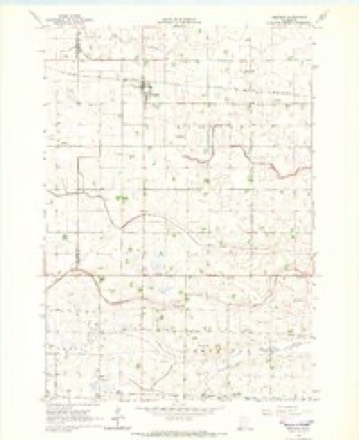
9 topographic sheets cover this place, the earliest surveyed in 1953 and the latest in 1986. It stands in Belview City. It lies in ZIP code area 56214. The Survey maps it on the Belview quadrangle. 291 people lived here at the 2020 count. It stands 1,070 feet above sea level.
On record in Belview
Buildings and businesses the archive holds for this place. Each opens its own page, with the source record it came from.
On the National Register 3 records
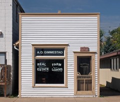 Gimmestad Land and Loan Officelisted 1980
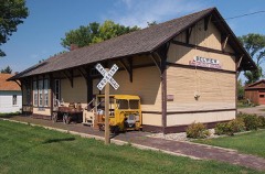 Minneapolis and St. Louis Railroad Depotlisted 1980
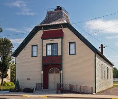 Odeon Theaterlisted 1974
Population over time
2 figuresBelview fell from 384 to 291 between 2010 and 2020. These are the recorded population figures Wikidata holds for this place, reached through the Geographic Names Information System number this page is keyed on rather than by name, so they belong to this place and not to another of the same name. Most are census counts, but not all are: an early figure may be a founding or settlement estimate, and an estimate published within five years of a census is left out. The change column is computed, and is left blank where more than 20 years separate a figure from the one before it, because a gap that long is not a change between two counts.
| Year | People | Change |
|---|---|---|
| 2010 | 384 | |
| 2020 | 291 | -93 (-24%) |
Topographic sheets covering this place
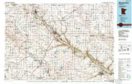
6 surveys from 9 printed sheetsMatched by testing this settlement's coordinate against the published boundary of every sheet in the United States Geological Survey's historical collection. Each opens the scanned sheet at the Survey.
- 1953 USGS New Ulm quadrangle1:250000, 3 printings
- 1957 USGS New Ulm quadrangle1:250000
- 1958 USGS New Ulm quadrangle1:250000
- 1965 USGS Belview quadrangle1:24000
- 1967 USGS New Ulm quadrangle1:250000
- 1986 USGS Montevideo quadrangle1:100000, 2 printings




In the county-history sources
2,180 words on this townshipThe History of Redwood County, Minnesota, published 1916 names this settlement in its chapter on Belview City. These are the passages that mention it, exactly as the scans read.
The village of Belview is one of the neatest and most active in the county, and the spirit of its citizens has done much for the progress and advancement of the whole community. It is located in section 8, Kintire township, on the Minneapolis & St. Louis Railroad, 119 miles from Minneapolis, and five miles from Echo, in Yellow Medicine county. Redwood Falls, with which it is connected with a splendid gravel state road, is fifteen miles away. Education, religious, public and commercial affairs, are given deep attention, and there are found here: Norwegian Lutheran Synod, Swedish Augustana Lutheran, and English Congregational churches; a school house costing $20,000 and covering eight grades and a four years' high school course; a circular park ; a village hall costing $4,000 ; a fire house and fire company with gasoline engine, hose truck, and chemical extinguishers; a modern creamery and Farmers' Elevator Co.; with other ele- vators, stores, and business enterprises necessary to an up-to-date and thrifty country village. The Commercial club, the Automobile club and the band all tend to make the place widely known.
Passage source: The History of Redwood County, Minnesota, published 1916.
The Belview Automobile club was organized in the spring of 1913. Its first and present officers are : A. O. Gimmestad, president; Wm. Mack, vice-president, H. O. Hegdal, secretary, N. W. Eide, treasurer. It has taken active interest in better roads, has bought five road drags, seeded road sides to tame grass, etc., and has had annual tours in different directions each year, annual banquets, and is a very active and lively club, consisting of about sixty members. A. O. Gimmestad is now, and has been the last three years, its member on the board of directors of the Minnesota State Automobile Association.
Passage source: The History of Redwood County, Minnesota, published 1916.
The first Belview Commercial Club was organized about 1892. In 1893 it secured a flour mill for Belview, gathered about $1,500 bonus and furnished the site and rock for foundation for the mill building. It has at various times been instrumental in locating enterprises and promoting the social as well as the material condition in and about Belview; has, the last five years furnished a lecture course of six to nine lectures and entertainments each year. It has the following active committees : Membership and entertainment, legislative and advertising, city development, manufacture and mercantile, park and band stand, good roads, lecture course and community calendar. Its present officers re:
Passage source: The History of Redwood County, Minnesota, published 1916.
Machine-read from a century-old scan, so expect the errors a machine makes: misspelled names, dropped words, stray characters.
Read the whole chapter on Belview City - it names this place 5 more 5 times.
Mines and quarries near this place
2 within 5 milesRegional context, not property-specific evidence. The federal mineral resources record lists 2 workings within 5 miles of Belview: 1 producer, 1 prospect. 1 still produces. What was taken out: Sand and Gravel, Construction, Granite. Distance is straight-line from the map coordinates, so a quarry counted here may appear on a neighbouring settlement's page as well.
| Where | Site | Commodity | Status | Recorded |
|---|---|---|---|---|
| Delano Granite Future Quarry | Granite | Prospect | ||
| Rikke Pit and Mill | Sand and Gravel, Construction | Producer |
Storms near this place
12 since 1998Regional context, not property-specific evidence. The National Weather Service names Belview in 12 storm reports between 1998 and 2019: 5 hail, 2 thunderstorm wind, 1 tornado, 1 flash flood. No death or injury is recorded in these reports. Each account below is quoted exactly as the forecast office filed it, from the NOAA Storm Events Database, and each date opens the federal record of that event.
| When | Event | Place named | Harm | What the report says |
|---|---|---|---|---|
| July 2011 | Tornado (EF1) | Belview | $200,000 | An EF-1 tornado continued along a path across northwest Redwood County, northeast to the Minnesota River, or approximately 3.5 miles north of Delhi where it crossed the Minnesota River into Renville County. The most concentrated area of tornadic damage with hundreds of trees uprooted or blown down was in the town of Belview. In addition, a few homes were damaged along the tornado path. |
| August 2001 | Hail | Belview | $25,000 | Numerous vehicles dented. Hail ripped through a few tin buildings. |
| June 2019 | Funnel Cloud | Belview | - | A firefighter observed a funnel cloud moving near their home. |
| July 2019 | Heavy Rain | Belview | - | There was a measured rainfall report of 3.44 inches near Belview. |
| July 2019 | Thunderstorm Wind | Belview | - | Several trees and power lines were blown down in Belview. |
| July 2018 | Flood | Belview | - | Southwest Minnesota received significant rainfall during the morning of Tuesday, July 3rd. Runoff from the excessive rainfall caused widespread flooding throughout the county. Several roads closed for a long period of time due to the flood waters. These roads include Highway 19 at the intersection of County Road 5 and Highway 14 from Tracy to Walnut Grove and Springfield. ||A 16-year-old driver in southwestern Minnesota had to climb out his cars back window after heavy rains washed out the road and he drove into a sinkhole. The Renville County Sheriffs Office said the sinkhole was formed after a culvert beneath the township road was washed out. |
| June 2014 | Flash Flood | Belview | - | Due to excessive rainfall in a short period of time, flood waters caused the basement walls of homes in Belview to collapse. |
| May 1998 | Thunderstorm Wind | Belview | - | Power lines down. Estimated windspeed. |
| April 2019 | Hail | Belview | - | no account filed |
| June 2016 | Hail | Belview | - | no account filed |
| September 2006 | Hail | Belview | - | no account filed |
| June 1998 | Hail | Belview | - | no account filed |
Nearest settlements
The eight closest, with where each one stands in the county. Distances are straight-line, computed from the Geographic Names Information System coordinates.
| Map | Place | Distance | Sheets |
|---|---|---|---|
| Delhi | 6.3 miles | 11 | |
| Vesta | 8.2 miles | 9 | |
| Seaforth | 8.8 miles | 10 | |
| Redwood Falls | 12.1 miles | 13 | |
| North Redwood | 12.8 miles | 13 | |
| Lucan | 14.2 miles | 9 | |
| Wabasso | 14.6 miles | 10 | |
| Milroy | 17.6 miles | 9 |
Elsewhere
Matched on this settlement's Geographic Names Information System number rather than its name, so it cannot be a different place of the same name in another state.
| Wikipedia article on Belview | An encyclopaedic summary. Its text is share-alike, so it is linked here rather than copied. |
| Wikidata item Q111976 | The structured record the population and elevation above come from. Public domain (CC0). |
Provenance
This settlement is recorded in the Geographic Names Information System as feature 639908. The sheet list is computed by point-in-boundary test against the United States Geological Survey's historical topographic inventory. Both are works of the United States government and carry no copyright under 17 U.S.C. 105.
Mines and quarries. USGS Mineral Resources Data System (MRDS) https://mrdata.usgs.gov/mrds/ A work of the United States government, no copyright under 17 U.S.C. 105.
Storms. NOAA National Centers for Environmental Information, Storm Events Database https://www.ncei.noaa.gov/stormevents/ A work of the United States government, no copyright under 17 U.S.C. 105. Narratives are quoted verbatim from the National Weather Service report and are not edited or summarised.