 Block
Blooming Prairie, Minnesota
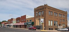
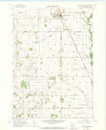
7 topographic sheets cover this place, the earliest surveyed in 1954 and the latest in 1985. It stands in Blooming Prairie City. It lies in ZIP code area 55917. The Survey maps it on the Blooming Prairie quadrangle. 1,974 people lived here at the 2020 count. It stands 1,293 feet above sea level.
On record in Blooming Prairie
Buildings and businesses the archive holds for this place. Each opens its own page, with the source record it came from.
On the National Register 1 record
Population over time
2 figuresBlooming Prairie fell from 1,996 to 1,974 between 2010 and 2020. These are the recorded population figures Wikidata holds for this place, reached through the Geographic Names Information System number this page is keyed on rather than by name, so they belong to this place and not to another of the same name. Most are census counts, but not all are: an early figure may be a founding or settlement estimate, and an estimate published within five years of a census is left out. The change column is computed, and is left blank where more than 20 years separate a figure from the one before it, because a gap that long is not a change between two counts.
| Year | People | Change |
|---|---|---|
| 2010 | 1,996 | |
| 2020 | 1,974 | -22 (-1%) |
Topographic sheets covering this place
5 surveys from 7 printed sheetsMatched by testing this settlement's coordinate against the published boundary of every sheet in the United States Geological Survey's historical collection. Each opens the scanned sheet at the Survey.
- 1954 USGS Mason City quadrangle1:250000, 2 printings
- 1957 USGS Mason City quadrangle1:250000
- 1958 USGS Mason City quadrangle1:250000
- 1967 USGS Blooming Prairie quadrangle1:24000
- 1985 USGS Albert Lea quadrangle1:100000, 2 printings




Mines and quarries near this place
1 within 5 milesRegional context, not property-specific evidence. The federal mineral resources record lists 1 working within 5 miles of Blooming Prairie: 1 producer. All of them still produce. What was taken out: Sand and Gravel, Construction. Distance is straight-line from the map coordinates, so a quarry counted here may appear on a neighbouring settlement's page as well.
| Where | Site | Commodity | Status | Recorded |
|---|---|---|---|---|
| Wrander Pit & Mill | Sand and Gravel, Construction | Producer |
Storms near this place
23 since 1997Regional context, not property-specific evidence. The National Weather Service names Blooming Prairie in 23 storm reports between 1997 and 2025: 10 hail, 5 tornado, 3 thunderstorm wind, 2 flood. The reports record 1 injury. Each account below is quoted exactly as the forecast office filed it, from the NOAA Storm Events Database, and each date opens the federal record of that event.
| When | Event | Place named | Harm | What the report says |
|---|---|---|---|---|
| June 2010 | Tornado (EF2) | Blooming Prairie | 1 hurt | This EF-2 tornado touched down and tracked east-northeast, and soon crossed the path of the Blooming Prairie EF-3 that had moved north-northeast about 10 minutes earlier. A manufactured home was obliterated by the EF-2. A woman inside the home was blown about 20 feet, but was found under debris, rescued by law enforcement, and survived. The tornado continued moving east-northeast, and several outbuildings were destroyed, along with many broken trees. The tornado continued into Dodge County. |
| December 2021 | Tornado (EF0) | Blooming Prairie | $105,000 | A narrow path of mostly tree damage was found just to the west of SE 89th Ave. An irrigation system was overturned, some farm outbuildings were damaged, and a small shed was tossed. |
| September 2025 | Hail | Blooming Prairie | - | Golf ball size hail on Hwy 30 west of Blooming Prairie. |
| July 2011 | Flash Flood | Blooming Prairie | - | The Blooming Prairie park area was flooded due to excessive rainfall. |
| June 2010 | Tornado (EF3) | Blooming Prairie | - | This tornado developed just north of the Steele/Freeborn County line, shortly after the dissipation in Freeborn County of the Newry tornado. This new tornado moved northeast, and initially, occasional trees were broken. Damage intensified somewhat when it hit a farm on State Highway 30 just west of Blooming Prairie. The tornado continued moving northeast, decimating crops. Some bean fields were scoured in spots. It intensified significantly to EF-3 2.5 miles northwest of Blooming Prairie, where a house was leveled, trees were snapped, and large portions of bark were removed. A pickup truck was lofted about 50 feet into the basement of the house. Several other houses sustained minor damage. The tornado dissipated just west of Highway 218 and 123rd Street. Video recorded by law enforcement and chasers. |
| June 2010 | Tornado (EF0) | Blooming Prairie | - | This tornado moved north-northeast and caused minor damage to outbuildings and broke several dozen trees. It exited Steele County about 3/4 mile south of Steele County Road 26 and continued into Dodge County. |
| May 2009 | Heavy Rain | Blooming Prairie | - | Local law enforcement officials measured 3.50 inches of rain from several periods of heavy rainfall during the late morning and early afternoon of May 6th. |
| June 2009 | Hail | Blooming Prairie | - | The public observed several hail reports including golf ball and nickel size. |
| June 2009 | Hail | Blooming Prairie | - | The local media relayed a large hail report west of Blooming Prairie. |
| July 2008 | Thunderstorm Wind | Blooming Prairie | - | Small tree downed, many branches and other debris on lawns. |
| July 2002 | Flash Flood | Blooming Prairie | - | Several streets blocked by high water. |
| July 2000 | Flood | Blooming Prairie | - | Estimated 3-4 inches of rain fell during period. Minor street flooding, several homes incurred minor basement flooding. |
| August 1999 | Flood | Blooming Prairie | - | Some streets in southwest portion of town under knee deep water. No basements flooded or damages reported. |
| July 1997 | Thunderstorm Wind | Blooming Prairie | - | Repair shop toppled by high winds. Several trees uprooted. Estimated windspeed. |
| July 2024 | Hail | Blooming Prairie | - | no account filed |
| October 2023 | Hail | Blooming Prairie | - | no account filed |
| September 2010 | Hail | Blooming Prairie | - | no account filed |
| May 2002 | Hail | Blooming Prairie | - | no account filed |
| July 2002 | Hail | Blooming Prairie | - | no account filed |
| June 1999 | Thunderstorm Wind | Blooming Prairie | - | no account filed |
| March 1998 | Hail | Blooming Prairie | - | no account filed |
| June 1998 | Hail | Blooming Prairie | - | no account filed |
| July 1997 | Tornado (F0) | Blooming Prairie | - | no account filed |
Nearest settlements
The eight closest, with where each one stands in the county. Distances are straight-line, computed from the Geographic Names Information System coordinates.
| Map | Place | Distance | Sheets |
|---|---|---|---|
| Union | 4.3 miles | 7 | |
| Bixby | 5.9 miles | 8 | |
| Summit | 8.0 miles | 7 | |
| Litomysl | 9.1 miles | 7 | |
| River Point | 11.4 miles | 7 | |
| Pratt | 12.2 miles | 9 | |
| Steele Center | 12.6 miles | 7 | |
| Ellendale | 13.3 miles | 7 |
Elsewhere
Matched on this settlement's Geographic Names Information System number rather than its name, so it cannot be a different place of the same name in another state.
| Wikipedia article on Blooming Prairie | An encyclopaedic summary. Its text is share-alike, so it is linked here rather than copied. |
| Wikidata item Q885377 | The structured record the population and elevation above come from. Public domain (CC0). |
Provenance
This settlement is recorded in the Geographic Names Information System as feature 640277. The sheet list is computed by point-in-boundary test against the United States Geological Survey's historical topographic inventory. Both are works of the United States government and carry no copyright under 17 U.S.C. 105.
Mines and quarries. USGS Mineral Resources Data System (MRDS) https://mrdata.usgs.gov/mrds/ A work of the United States government, no copyright under 17 U.S.C. 105.
Storms. NOAA National Centers for Environmental Information, Storm Events Database https://www.ncei.noaa.gov/stormevents/ A work of the United States government, no copyright under 17 U.S.C. 105. Narratives are quoted verbatim from the National Weather Service report and are not edited or summarised.