 Block
Hay Creek, Minnesota
11 topographic sheets cover this place, the earliest surveyed in 1953 and the latest in 1989. It stands in Hay Creek Township. It lies in ZIP code area 55066. The Survey maps it on the Goodhue East quadrangle.
On record in Hay Creek
Buildings and businesses the archive holds for this place. Each opens its own page, with the source record it came from.
On the National Register within a mile 2 records
The National Register names another town for these. They stand within one mile of this settlement's coordinate.
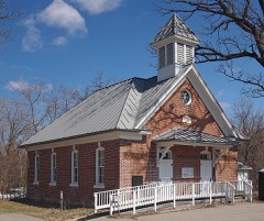 District No. 20 Schoollisted 1980 · 0.3 miles away
- Immanuel Lutheran Churchlisted 1980 · 0.4 miles away
Topographic sheets covering this place
7 surveys from 11 printed sheetsMatched by testing this settlement's coordinate against the published boundary of every sheet in the United States Geological Survey's historical collection. Each opens the scanned sheet at the Survey.
- 1953 USGS Saint Paul quadrangle1:250000, 3 printings
- 1953 USGS St. Paul quadrangle1:250000
- 1959 USGS Saint Paul quadrangle1:250000
- 1959 USGS St. Paul quadrangle1:250000
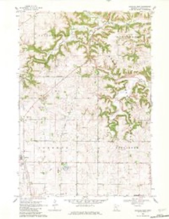
- 1968 USGS Goodhue East quadrangle1:24000, 2 printings
- 1985 USGS Rochester quadrangle1:100000
- 1989 USGS Rochester quadrangle1:100000, 2 printings




In the county-history sources
12,355 words on this townshipHistory of Goodhue County, Including a Sketch of the Territory and State of Minnesota; Together with an Account of the Early French Discoveries, Indian Massacres, the Part Borne by Minnesota's Patriots in the War of the Great Rebellion, and a Full and Complete History of the County from the Time of Its Occupancy by Swiss Missionaries in 1838. Pioneer Incidents, Biographical Sketches of Early and Prominent Settlers and Representative Men, and of Its Cities, Towns, Churches, Schools, Secret Societies, Etc, published 1878 names this settlement in its chapter on Hay Creek Township. These are the passages that mention it, exactly as the scans read.
This township was organized in 1858. The first settler was Mr. Eger, who located a claim on section two, near the line of Wacoota township, in the spring of 1854. Erenest Schubert, Mr. Wakefield, George Steele, and Henry Einnzih settled in the township in 1854. In the fall of that year George Frederick, father of Mr. Frederick, of the firm of Frederick & Hack, Red Wing, came to the township, but removed to Belle Creek immediately after.
BEAUFORD, JOHN H., M. D., sec. 19, P. 0. Hay Creek. Born in Vergennes, Addison Co., Vermont, July 19, 1839. In the spring of 1864, he entered the Rutledge Commercial College, Springfield, 111. ; graduated in 1867. Commenced the study of medicine, and attended lectures in 1869, at Evansville, Ind. ; graduated as M. D. in 1872. Went to St. Louis, where he continued his studies with the advantage of lectures from the best medical talent. Remained there until the summer of 1875, when he came to Minnesota, landing in Red Wing, July 3d, where he resided one year. Came to this place in 1876, and has been engaged in the practice of medicine ever since. Has now in course of erection a residence, in which he will establish a drug store. Owns one acre of land. Was married June 24, 1873, to Lena Matz. She was born in Germany, in 1849. Have two children, Ida and Fred. M. Family attend the M. E. church.
PEULM, WILLIAM, carpenter. Lives on sec. '26, P. 0. Hay Creek. Born in Germany, Oct. 20, 1812. Came with his parents to the United States in 1815. Settled in Indiana, where his parents died in 1819. Enlisted in 1861, in the 14th Ind. I. Was engaged principally in garrison duty at Chattanooga, Knoxville, etc. Mustered out in June, 1865. Came to this county in 1873. Owns 160 acres in sec. 34. Is a member of the German Lutheran Church.
Machine-read from a century-old scan, so expect the errors a machine makes: misspelled names, dropped words, stray characters.
Read the whole chapter on Hay Creek Township - it names this place 3 more 3 times.
Fires near this place
7 since 1994Regional context, not property-specific evidence. The federal wildfire occurrence database lists 7 fires within 5 miles of Hay Creek between 1994 and 2020, burning about 45 acres in total. None started naturally. None was recorded as arson. Distance is straight-line from the map coordinates, so a fire counted here may appear on a neighbouring settlement's page as well.
| Reported cause | Fires |
|---|---|
| Debris and open burning | 3 |
| Recreation and ceremony | 2 |
| Equipment and vehicle use | 1 |
| Missing data/not specified/undetermined | 1 |
The most recent of them, most recent first, with the day each was reported and the service that recorded it.
| Date | Cause | Size | Reported by | Name on the report |
|---|---|---|---|---|
| 23 September 2012 | Debris and open burning | under an acre | Minnesota Department of Natural Resources | not named |
| 7 May 2018 | Recreation and ceremony | 5.5 acres | Minnesota Department of Natural Resources | not named |
| 23 April 1994 | Recreation and ceremony | 2.0 acres | Minnesota Department of Natural Resources | not named |
| 14 April 2015 | Debris and open burning | 3.0 acres | Minnesota Department of Natural Resources | not named |
| 15 March 2020 | Missing data/not specified/undetermined | 4.4 acres | Minnesota Department of Natural Resources | not named |
| 24 November 2012 | Debris and open burning | 15 acres | Minnesota Department of Natural Resources | not named |
| 3 October 2012 | Equipment and vehicle use | 15 acres | Minnesota Department of Natural Resources | not named |
Settlements close enough to share some of these fires:
Mines and quarries near this place
4 within 5 milesRegional context, not property-specific evidence. The federal mineral resources record lists 4 workings within 5 miles of Hay Creek: 2 producers, 2 past producers. 2 still produce. What was taken out: Clay, Sand and Gravel, Construction. Distance is straight-line from the map coordinates, so a quarry counted here may appear on a neighbouring settlement's page as well.
| Where | Site | Commodity | Status | Recorded |
|---|---|---|---|---|
| Red Wing Sand & Gravel Co. Mine | Sand and Gravel, Construction | Producer | ||
| Clay Bank Pits | Clay | Producer | 1875 | |
| Red Wing Sewer Pipe Clay Pit No 1 | Clay | Past Producer | ||
| Red Wing Sewer Pipe Clay Pit No 2 | Clay | Past Producer |
Storms near this place
3 since 2008Regional context, not property-specific evidence. The National Weather Service names Hay Creek in 3 storm reports between 2008 and 2026: 1 thunderstorm wind, 1 heavy rain, 1 hail. No death or injury is recorded in these reports. Each account below is quoted exactly as the forecast office filed it, from the NOAA Storm Events Database, and each date opens the federal record of that event.
| When | Event | Place named | Harm | What the report says |
|---|---|---|---|---|
| June 2012 | Heavy Rain | Hay Creek | - | A measured rainfall report of 4.54 inches occurred in less than 18 hours. |
| July 2008 | Thunderstorm Wind | Hay Creek | - | A barn and two turkey barns destroyed near intersection of County Road 1 and 6. |
| April 2026 | Hail | Hay Creek | - | no account filed |
Nearest settlements
The eight closest, with where each one stands in the county. Distances are straight-line, computed from the Geographic Names Information System coordinates.
| Map | Place | Distance | Sheets |
|---|---|---|---|
| Belvidere Mills | 3.3 miles | 11 | |
| Red Wing | 4.9 miles | 15 | |
| Claybank | 5.8 miles | 10 | |
| Wacouta | 6.8 miles | 16 | |
| Goodhue | 7.6 miles | 11 | |
| Wacouta Beach | 8.0 miles | 16 | |
| Harliss | 8.6 miles | 15 | |
| Bellechester | 8.7 miles | 11 |
Provenance
This settlement is recorded in the Geographic Names Information System as feature 644751. The sheet list is computed by point-in-boundary test against the United States Geological Survey's historical topographic inventory. Both are works of the United States government and carry no copyright under 17 U.S.C. 105.
Wildfire. Short, Karen C. 2022. Spatial wildfire occurrence data for the United States, 1992-2020 [FPA_FOD_20221014]. 6th Edition. Fort Collins, CO: Forest Service Research Data Archive. https://doi.org/10.2737/RDS-2013-0009.6 Collected with United States Government funding and usable without additional permissions or fees.
Mines and quarries. USGS Mineral Resources Data System (MRDS) https://mrdata.usgs.gov/mrds/ A work of the United States government, no copyright under 17 U.S.C. 105.
Storms. NOAA National Centers for Environmental Information, Storm Events Database https://www.ncei.noaa.gov/stormevents/ A work of the United States government, no copyright under 17 U.S.C. 105. Narratives are quoted verbatim from the National Weather Service report and are not edited or summarised.